ATL Tropical Depression GUSTAV - Personal Forecasts
Moderator: S2k Moderators
-
cycloneye

- Admin

- Posts: 139050
- Age: 67
- Joined: Thu Oct 10, 2002 10:54 am
- Location: San Juan, Puerto Rico
ATL Tropical Depression GUSTAV - Personal Forecasts
This thread will be used for the members who have personal forecasts about Gustav to post them here and not cause more traffic in the main thread.Remember to post the disclaimer.
0 likes

Re: Personal Forecasts Thread
The following post is NOT an official forecast and should not be used as such. It is just the opinion of the poster and may or may not be backed by sound meteorological data. It is NOT endorsed by any professional institution including storm2k.org For Official Information please refer to the NHC and NWS products.

This is basically nothing but an educated guess with regards to track. In fact, it's already starting to look like I may have plotted it too far to the left. I guess we'll find out.
Intensity-wise, it's essentially another Fay - difficult to predict due to possible land interaction. The displayed forecast intensity assumes a track down the middle.
Regardless, we all know what happens when a lot of rain gets dumped on Haiti.
0 likes


-
Tampa Bay Hurricane

- Category 5

- Posts: 5594
- Age: 36
- Joined: Fri Jul 22, 2005 7:54 pm
- Location: St. Petersburg, FL
Re: Personal Gustav Forecasts
Personal Forecast Disclaimer:
The posts in this forum are NOT official forecast and should not be used as such. They are just the opinion of the poster and may or may not be backed by sound meteorological data. They are NOT endorsed by any professional institution or storm2k.org. For official information, please refer to the NHC and NWS products.[/
Intensity Forecast:
Going over extreme heat content waters until 72 hours, then hits Cuba, goes
over the loop current and ramps up again.
Now- 50 mph
May DIE COMPLETELY if the MOUNTAINS OF HAITI/CUBA KILL IT
Otherwise:
24 hours- 75 mph
48 hours- 110 mph
72 hours- 150 mph- explosive heat content just south of Cuba
Crosses Cuba, decreases to 125 mph
Then, by 96 hours moves over the heart of the
loop current: 165 mph
108 hours (4.5 days): 175 mph
Landfall at 120 hours along the Gulf Coast: 150 mph (weakens some as heat content
drops off in the north gulf + shear increase in association with trough weakens it)
***Exact location of landfall TOO UNCERTAIN****
***NOT OFFICIAL***
Prayers with those in the path. Again, I am REALLY PRAYING for Gulf Coast
and Caribbean Residents getting hit by this storm.
0 likes
-
Matt-hurricanewatcher

- Category 5
- Posts: 11649
- Age: 38
- Joined: Fri Nov 26, 2004 11:09 pm
- Location: Portland,OR
- Contact:
Re: Personal Gustav Forecasts
Personal Forecast Disclaimer:
The posts in this forum are NOT official forecast and should not be used as such. They are just the opinion of the poster and may or may not be backed by sound meteorological data. They are NOT endorsed by any professional institution or storm2k.org. For official information, please refer to the NHC and NWS products.
At the moment I don't really putting together a real forecast, but here is a few thoughts.
I expect this will head 250-265 degree's for the next 12 hours, this should make sure that it don't make landfall over Cuba. Also the MLC is not likely to remove its self from Hati, so I expect a new one to form over the next 12 hours. The environment should improve as it moves away from land, with much better inflow into the system. I expect that by tomarrow night to be around 50 mph. Once the innercore redevelops around 24-30 hours from now; then I expect strengthing. The environment should be favorable upper level wise and sst's, for a hurricane of 70-75 knots once near 19-19.5/81 around 48-56 hour time frame.
I also feel that this will hit the western Tip of cuba as a 75-80 knot hurricane. Once it gets back into the Gulf around 96 hours...I expect some slow development...In which case by 120-126 hours,,,I expect a landfall over southwestern LA as a 90 knot hurricane. It could be weaker or stronger.
0 likes
-
MisUndrstd
- Tropical Low

- Posts: 10
- Joined: Sun Mar 23, 2008 12:14 pm
-
Extremeweatherguy

- Category 5
- Posts: 11095
- Joined: Mon Oct 10, 2005 8:13 pm
- Location: Houston, TX
Re: Personal Gustav Forecasts
Here is my 7 day forecast for Gustav...
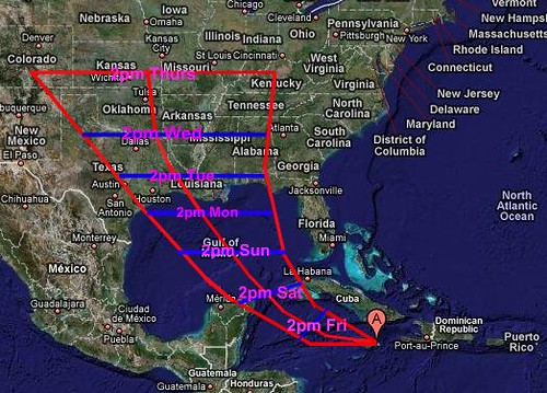
2PM FRI: 70KT (81mph)
2PM SAT: 80KT (92mph)
2PM SUN: 100KT (115mph)
2PM MON: 110KT (127mph)
2PM TUE: 85KT (98mph)
2PM WED: 55KT (63mph)
2PM THU: 30KT (35mph)
Summary: I believe that Gustav will continue to get his act together over the next few days and eventually become a major hurricane in the Gulf of Mexico. Upon landfall, which I predict to occur late in the day on Monday, the storm should be a strong Category 3 or weak Category 4 hurricane. After landfall occurs, I believe Gustav will gradually work his way into the mid section of the country and maintain its strength well inland (similar to what Katrina did in 2005). Gustav will likely still be a moderate/strong tropical storm when it approaches the TX/LA/OK/AK border region by Wednesday afternoon, and it will still be a healthy depression upon entering Kansas on Thursday. As the storm interacts with an incoming cold front on Wednesday and Thursday, enhanced heavy rainfall could occur in parts of northern Texas, Oklahoma, NW Louisiana, Arkansas and Kansas. Eventually (day 7+), I expect Gustav to be absorbed by the incoming front. The leftover remnants will likely then head towards Missouri, Illinois and Indiana.
What this forecast means...
- Devastating storm surge is possible along the Louisiana and Mississippi coastlines.
-Hurricane force winds (either sustained or in gusts) will be felt as far west as SE Texas and as far east as coastal Mississippi.
-Tropical storm force winds will spread well inland to regions where it is very uncommon. Parts of NW Louisina, NE Texas, eastern Oklahoma and western Arkansas may require the issuance of Inland tropical storm warnings.
-tornadoes could be a major issue from late Monday through Friday as the circulation moves inland and then interacts with an incoming frontal boundary.
The posts in this forum are NOT official forecast and should not be used as such. They are just the opinion of the poster and may or may not be backed by sound meteorological data. They are NOT endorsed by any professional institution or storm2k.org. For official information, please refer to the NHC and NWS products.
0 likes
-
Tampa Bay Hurricane
- Category 5
- Posts: 5594
- Age: 36
- Joined: Fri Jul 22, 2005 7:54 pm
- Location: St. Petersburg, FL
Re: Personal Gustav Forecasts
Personal Forecast Disclaimer:
The posts in this forum are NOT official forecast and should not be used as such. They are just the opinion of the poster and may or may not be backed by sound meteorological data. They are NOT endorsed by any professional institution or storm2k.org. For official information, please refer to the NHC and NWS products.[/quote]
Update on the forecast. Though heat content is high, there may be more shear and dry air influence
if the trough induces this upon Gustav.
24 hours- 80 mph
48 hours- 120 mph
72 hours- 175 mph- extreme heat content over the loop current
96 hours- Landfall- Dry air comes in from the west and disrupts Gustav, resulting in some weakening to a
still formidable 150 mph storm. Landfall at 150 mph somewhere near Louisiana or perhaps
in Louisiana, with the potential for a devastating storm surge from prior strength in the
Gulf.
120 hours- too uncertain- perhaps about 75 mph and weakening.
0 likes
-
weatherman21

- Tropical Depression

- Posts: 67
- Joined: Mon Apr 23, 2007 11:07 am
Re: Personal Gustav Forecasts
Hello to everyone. I thank the creators of this forum and the participants who post. I see great effort and a true desire from those who post.
I have been watching the Tropical Atlantic the past several days and the development of what is now two tropical cyclones: one being Hurricane Gustav and the other being Tropical Storm Hanna. I have not posted on here in a while, but I just wanted to pass along my thoughts on Hurricane Gustav. I am not professional, but I enjoy analyzing weather and in particular, the water vapor satellite to percieve how weather is behaving on a synoptic scale.
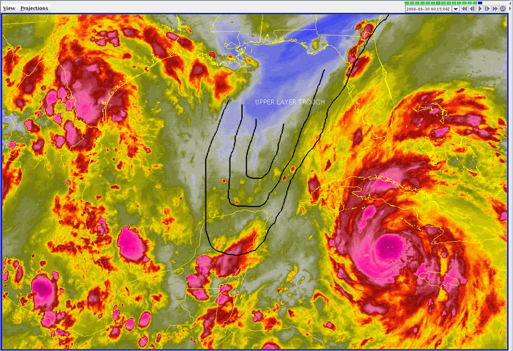
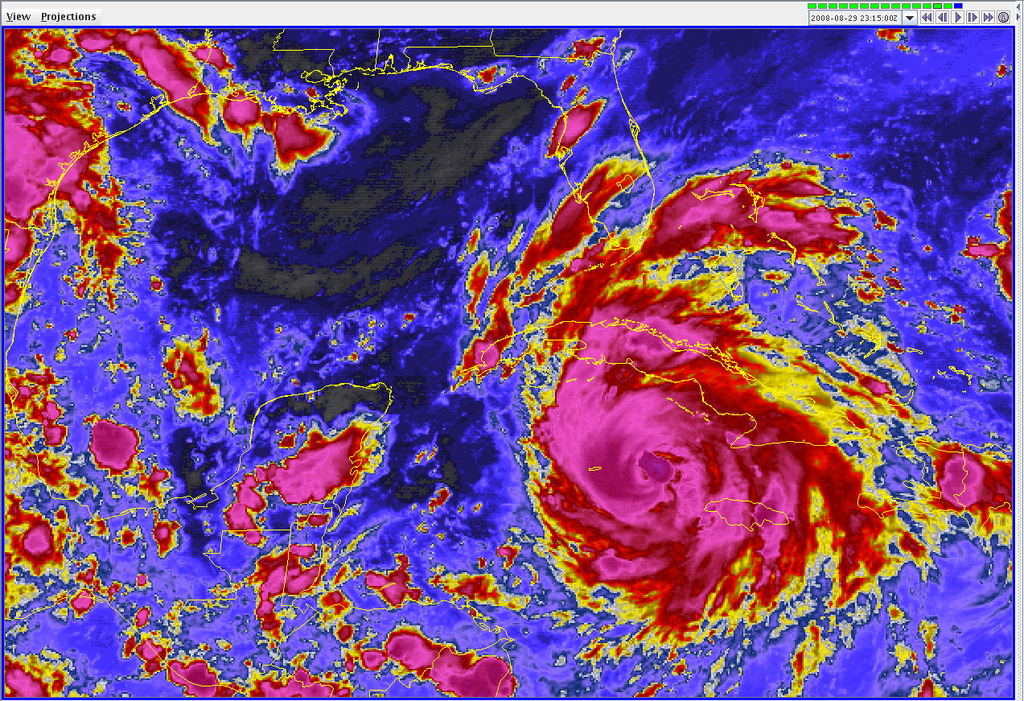
As I observe the synoptic factors involved in the track forecast and the intensity forecast of Hurricane Gustav, I see the longwave upper-layer trough over the Gulf of Mexico being a large factor and water vapor satellite detects the longwave trough really well tonight. The infrared satellite presentation of Hurricane Gustav tonight reveals a rotating deep convective shield surrounding the low pressure center of the hurricane. There is a small area of very deep convection to the north side of the LPC. At this time, as of 01:15Z/9:15PM EDT, I suspect the LPC of Hurricane Gustav is near 19N, 80W and the area of very deep convection is on the north side of this. From observing a time lapse of the infrared satellite presentation, I see the cyclone acquiring more strength and is most likely increasing in intensity.
Below I have posted an image of Hurricane Gustav consisting of water vapor satellite and I overlaid where I think the boundary line is for the upper-layer trough. From observing the time lapse of the water vapor satellite I conclude that the hurricane is reaching the point where a consistant northwest motion is to take form through the northern Carribbean Sea into the southern Gulf of Mexico.
I suspect, once the hurricane begins to encounter the upper-layer trough more in the next couple days, a leveling off in strength could occur. I do give the cyclone about two days for increase in intensity. After that, I see the trough having some degree of impact on the cyclone. I do not see, however, a dramatic decrease in strength of the cyclone even while encountering the shear from the trough in a couple days. As a high pressure ridge tracks southward towards the Gulf Coast States, I suppose this will prevent strong upper-layer winds from hendering intensification. The cyclone may be able to maintain its intensity until landfall and not weaken. Even as the trough is now centered over the Gulf of Mexico, I see the trough not being a huge factor in terms of strength of the cyclone. That is all I will speculate on the intensity prediction.
The track appears reasonable, given the two synoptic factors involved: the trough over the Gulf of Mexico and the high pressure ridge tracking south towards the southern Gulf States. From water vapor satellite, I do not see the trough being very strong and does not appear to be a factor that would make the hurricane pull northward, but instead, due to the high pressure ridge tracking southward towards the Gulf States, I see the NHC forecast track as being good with a northwest motion towards the northwest until the cyclone reaches the Louisiana coastline. From there, due to the high pressure ridge to the north over the souteast CONUS, a shift towards the wnw is possible once the cyclone reaches Louisiana. There may indeed be a slowing in the pace as well by that time.
I have posted a couple more images below:
This image below is an infrared satellite view at 01:15Z:
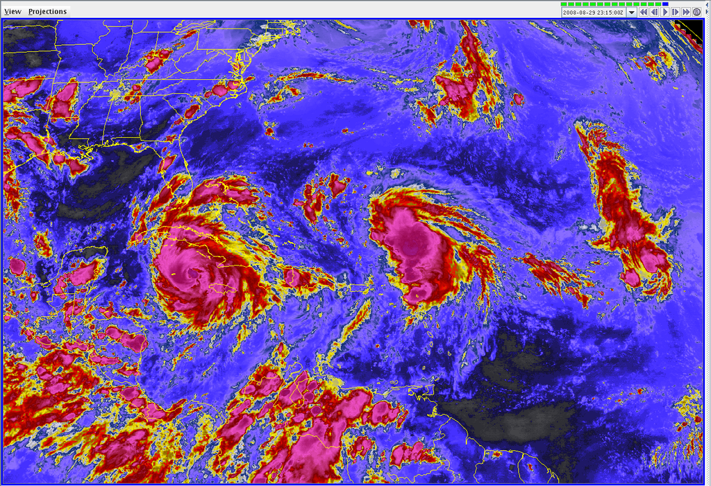
This image is a more broad scale of infrared satellite with Tropical Storm Hanna to the right at 01:15Z:
I have been watching the Tropical Atlantic the past several days and the development of what is now two tropical cyclones: one being Hurricane Gustav and the other being Tropical Storm Hanna. I have not posted on here in a while, but I just wanted to pass along my thoughts on Hurricane Gustav. I am not professional, but I enjoy analyzing weather and in particular, the water vapor satellite to percieve how weather is behaving on a synoptic scale.
As I observe the synoptic factors involved in the track forecast and the intensity forecast of Hurricane Gustav, I see the longwave upper-layer trough over the Gulf of Mexico being a large factor and water vapor satellite detects the longwave trough really well tonight. The infrared satellite presentation of Hurricane Gustav tonight reveals a rotating deep convective shield surrounding the low pressure center of the hurricane. There is a small area of very deep convection to the north side of the LPC. At this time, as of 01:15Z/9:15PM EDT, I suspect the LPC of Hurricane Gustav is near 19N, 80W and the area of very deep convection is on the north side of this. From observing a time lapse of the infrared satellite presentation, I see the cyclone acquiring more strength and is most likely increasing in intensity.
Below I have posted an image of Hurricane Gustav consisting of water vapor satellite and I overlaid where I think the boundary line is for the upper-layer trough. From observing the time lapse of the water vapor satellite I conclude that the hurricane is reaching the point where a consistant northwest motion is to take form through the northern Carribbean Sea into the southern Gulf of Mexico.
I suspect, once the hurricane begins to encounter the upper-layer trough more in the next couple days, a leveling off in strength could occur. I do give the cyclone about two days for increase in intensity. After that, I see the trough having some degree of impact on the cyclone. I do not see, however, a dramatic decrease in strength of the cyclone even while encountering the shear from the trough in a couple days. As a high pressure ridge tracks southward towards the Gulf Coast States, I suppose this will prevent strong upper-layer winds from hendering intensification. The cyclone may be able to maintain its intensity until landfall and not weaken. Even as the trough is now centered over the Gulf of Mexico, I see the trough not being a huge factor in terms of strength of the cyclone. That is all I will speculate on the intensity prediction.
The track appears reasonable, given the two synoptic factors involved: the trough over the Gulf of Mexico and the high pressure ridge tracking south towards the southern Gulf States. From water vapor satellite, I do not see the trough being very strong and does not appear to be a factor that would make the hurricane pull northward, but instead, due to the high pressure ridge tracking southward towards the Gulf States, I see the NHC forecast track as being good with a northwest motion towards the northwest until the cyclone reaches the Louisiana coastline. From there, due to the high pressure ridge to the north over the souteast CONUS, a shift towards the wnw is possible once the cyclone reaches Louisiana. There may indeed be a slowing in the pace as well by that time.
I have posted a couple more images below:
This image below is an infrared satellite view at 01:15Z:
This image is a more broad scale of infrared satellite with Tropical Storm Hanna to the right at 01:15Z:
0 likes
-
JonathanBelles
- Professional-Met

- Posts: 11430
- Age: 33
- Joined: Sat Dec 24, 2005 9:00 pm
- Location: School: Florida State University (Tallahassee, FL) Home: St. Petersburg, Florida
- Contact:
The posts in this forum are NOT official forecast and should not be used as such. They are just the opinion of the poster and may or may not be backed by sound meteorological data. They are NOT endorsed by any professional institution or storm2k.org. For official information, please refer to the NHC and NWS products.
No full advisory tonight, but I did want to comment. I am currently thinking landfall will be east of current NHC track by up to 10 miles as a cat 3. The entire gulf coast will be affected no matter the landfall point. Florida is not out of the woods in terms of rainfall. Gustav and Hanna will be close enough to bring rain to the state. Wind should not be an issue in Florida or AL. Rain will extend well past the eye of the system. Terrebonne Parish is my current thinking with possibilities of 100 miles east and west of this parish.
No full advisory tonight, but I did want to comment. I am currently thinking landfall will be east of current NHC track by up to 10 miles as a cat 3. The entire gulf coast will be affected no matter the landfall point. Florida is not out of the woods in terms of rainfall. Gustav and Hanna will be close enough to bring rain to the state. Wind should not be an issue in Florida or AL. Rain will extend well past the eye of the system. Terrebonne Parish is my current thinking with possibilities of 100 miles east and west of this parish.
0 likes
-
TampaSteve

- Tropical Storm

- Posts: 210
- Joined: Sat Sep 02, 2006 4:05 pm
- Location: Riverview, FL
Re: Personal Gustav Forecasts
The following post is NOT an official forecast and should not be used as such. It is just the opinion of the poster and may or may not be backed by sound meteorological data. It is NOT endorsed by any professional institution including storm2k.org For Official Information please refer to the NHC and NWS products.
I'm thinking landfall as a solid Cat 3 (120-130 mph) near the TX/LA border. Any takers???
0 likes
-
StormWarning1
- Category 1

- Posts: 254
- Joined: Sun Jul 10, 2005 9:29 pm
- Location: Nashville TN
Re: Personal Gustav Forecasts
TampaSteve wrote:The following post is NOT an official forecast and should not be used as such. It is just the opinion of the poster and may or may not be backed by sound meteorological data. It is NOT endorsed by any professional institution including storm2k.org For Official Information please refer to the NHC and NWS products.
I'm thinking landfall as a solid Cat 3 (120-130 mph) near the TX/LA border. Any takers???
Yeah,
Freeport TX to Lake Charles La.
I will bite on the slow down and turn to the West.
Intensity wise it would probably weaken to 90 -110 range.
0 likes
Re: Personal Gustav Forecasts
The following post is NOT an official forecast and should not be used as such. It is just the opinion of the poster and may or may not be backed by sound meteorological data. It is NOT endorsed by any professional institution including storm2k.org For Official Information please refer to the NHC and NWS products.
Forecast: Cat 3 (125 mph)
Landfall Location: South of Houma, LA
Time: Monday around Noon.
Peak Intensity: 155 mph/933 mb Sunday afternoon.
Lower intensity from the peak due to ERC and track over lower heat content Sunday night.
More discussion: http://philadelphiaweather.blogspot.com/
Forecast: Cat 3 (125 mph)
Landfall Location: South of Houma, LA
Time: Monday around Noon.
Peak Intensity: 155 mph/933 mb Sunday afternoon.
Lower intensity from the peak due to ERC and track over lower heat content Sunday night.
More discussion: http://philadelphiaweather.blogspot.com/
0 likes
-
JonathanBelles
- Professional-Met
- Posts: 11430
- Age: 33
- Joined: Sat Dec 24, 2005 9:00 pm
- Location: School: Florida State University (Tallahassee, FL) Home: St. Petersburg, Florida
- Contact:
The posts in this forum are NOT official forecast and should not be used as such. They are just the opinion of the poster and may or may not be backed by sound meteorological data. They are NOT endorsed by any professional institution or storm2k.org. For official information, please refer to the NHC and NWS products.
Another Update on Gustav: Hurricane Gustav is recovering from a Cuban landfall. It is a category 3 hurricane with winds of 120mph, but do not let this fool you. Gustav will restrengthen. Evacuations out of NOLA and surrounding cities is well underway. The death toll of Gustav will not be nearly as high as Katrina because of preparation measures, but damage tolls has the ability to be close. NOLA will be on the wrong side of this storm and they will face 100mph+ winds with higher gusts, heavy rain and high surge. My current landfall point is coastal LaForche or Jefferson Parish, LA with winds of 135mph with surge of 15-21 feet to the east of that north of the mouth of the Mississippi River. 6-12" is possible in all of LA with higher amounts after Gustav stalls, which it is expected to do Wednesday in eastern TX. This system is coming, and everyone needs to prepare immediately.
Another Update on Gustav: Hurricane Gustav is recovering from a Cuban landfall. It is a category 3 hurricane with winds of 120mph, but do not let this fool you. Gustav will restrengthen. Evacuations out of NOLA and surrounding cities is well underway. The death toll of Gustav will not be nearly as high as Katrina because of preparation measures, but damage tolls has the ability to be close. NOLA will be on the wrong side of this storm and they will face 100mph+ winds with higher gusts, heavy rain and high surge. My current landfall point is coastal LaForche or Jefferson Parish, LA with winds of 135mph with surge of 15-21 feet to the east of that north of the mouth of the Mississippi River. 6-12" is possible in all of LA with higher amounts after Gustav stalls, which it is expected to do Wednesday in eastern TX. This system is coming, and everyone needs to prepare immediately.
0 likes
Who is online
Users browsing this forum: No registered users and 39 guests