OuterBanker wrote:First major Bertha was a fish.
ATL JOSEPHINE: Remnants - Discussion
Moderator: S2k Moderators
Re: ATL JOSEPHINE: Remnants - Discussion
True, but the ridge we have wasn't in place then....doesn't look like ridge has moved much in a week...i guess it would also depend on latitude of any system....if further north than ike and heads west...etc
0 likes
-
OuterBanker
- S2K Supporter

- Posts: 1704
- Joined: Wed Feb 26, 2003 10:53 am
- Location: Nags Head, NC
- Contact:
The storm formerly known as Josephine will be in the Bahamas this weekend. As who I don't know. Will we really accept Kyle when we know he should be wearing a dress. That's the question. I know Californian's will have no problem accepting it no matter the name. But, here in the south it could be a problem 
0 likes
-
Matt-hurricanewatcher

- Category 5

- Posts: 11649
- Age: 38
- Joined: Fri Nov 26, 2004 11:09 pm
- Location: Portland,OR
- Contact:
Re: ATL JOSEPHINE: Remnants - Discussion
Its time to put this under a "yellow" and talk about the chance for some development over the next few days at the leasted.
0 likes
-
gatorcane

- S2K Supporter
- Posts: 23499
- Age: 46
- Joined: Sun Mar 13, 2005 3:54 pm
- Location: Boca Raton, FL
Re: ATL JOSEPHINE: Remnants - Discussion
Matt, I've had my eye on it but the convection is not sustaining in any one given place, hence why the NHC has not put a yellow on it. I thought it would earlier today but we need to see some convection sustain in one place first.
0 likes
-
HurricaneFreak
- Tropical Depression

- Posts: 80
- Joined: Sat Sep 06, 2008 11:37 pm
- Location: Boca Raton,Florida
-
bob rulz
- Category 5
- Posts: 1667
- Age: 34
- Joined: Sat Jan 28, 2006 7:30 pm
- Location: Salt Lake City, Utah
Re:
HURAKAN wrote:Fish is when it doesn't affect land. It doesn't need to be landfall. Bertha was no fish.
Bertha and Cristobal had very minimal effects (on Bermuda and North Carolina respectively); pretty much just rain and some gusty winds. They both might as well be fish storms.
I agree that ex-Josephine should be given a mention in the 2am TWO. She looks better now than she has at any point since she dissipated.
0 likes

Re: ATL JOSEPHINE: Remnants - Discussion
This thread will get a lot more attention tomorrow.The convection isn't dying off either.
0 likes

Re: ATL JOSEPHINE: Remnants - Discussion
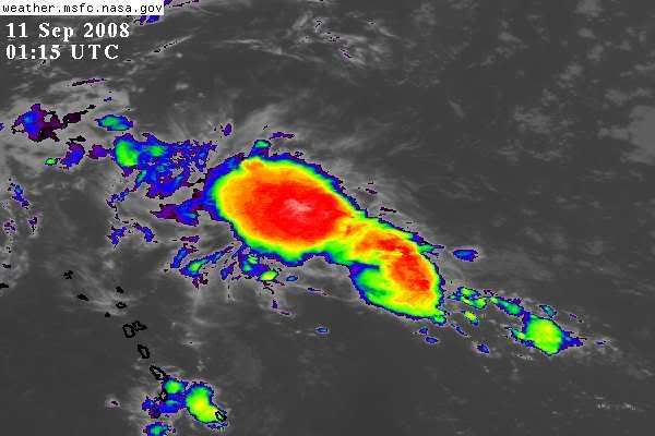
Very circular large mass of convection north of PR this morning. Only models that develop it are CMC and NAM. Bears watching.

0 likes
-
jlauderdal
- S2K Supporter
- Posts: 6771
- Joined: Wed May 19, 2004 5:46 am
- Location: NE Fort Lauderdale
- Contact:
Re:
bob rulz wrote:How is this still not mentioned in the TWO?
Maybe they're waiting for visibles?
i demand recon today,
NATIONAL WEATHER SERVICE MIAMI FL
233 AM EDT THU SEP 11 2008
SYNOPSIS...HURRICANE IKE...OVER THE CENTRAL GULF OF MEX...WILL
CONTINUE TO MOVE WNW AWAY FROM S FLA. HIGH PRES...OVER THE SE U.S.
AND THE W ATLC...WILL SLOW BUILD WESTWARD AND OVER THE ENTIRE FLA
PENINSULA OVER THE WEEKEND. INTO NEXT WEEK...AN UPPER LOW DEEPENS E
OF THE BAHAMAS DEVELOPING AN INVERTED SURFACE TROUGH SURFACE WHICH
WILL MOVE W AND NEAR S FLA BY MIDWEEK.
EXTENDED PERIOD...SUN THROUGH WEDNESDAY
SATL AND MODELS DEPICT
A LOW LVL CLOUD MASS NW OF PUERTO RICO. MODELS TREND THIS SYSTEM W
AS A WAVE AND A SLIGHT INCREASE IN POPS POSSIBLE SUN. A SEASONAL
APPROACH CAN BE EXPECTED MON AND TUE BUT A WAVE APPROACHING WED MAY
INCREASE POPS AGAIN.
0 likes
-
Lowpressure

- S2K Supporter
- Posts: 2032
- Age: 57
- Joined: Sun Sep 14, 2003 9:17 am
- Location: Charlotte, North Carolina
Re: ATL JOSEPHINE: Remnants - Discussion
Looks like a case of all eyes looking in the GOM- understandibly so. It has held together rather well for a while now.
0 likes
-
HURAKAN

- Professional-Met

- Posts: 46086
- Age: 37
- Joined: Thu May 20, 2004 4:34 pm
- Location: Key West, FL
- Contact:
Still nothing.
TROPICAL WEATHER OUTLOOK
NWS TPC/NATIONAL HURRICANE CENTER MIAMI FL
800 AM EDT THU SEP 11 2008
FOR THE NORTH ATLANTIC...CARIBBEAN SEA AND THE GULF OF MEXICO...
THE NATIONAL HURRICANE CENTER IS ISSUING ADVISORIES ON HURRICANE
IKE...LOCATED ABOUT 575 MILES EAST OF BROWNSVILLE TEXAS AND ABOUT
270 MILES SOUTH-SOUTHEAST OF THE MOUTH OF THE MISSISSIPPI RIVER.
ELSEWHERE...TROPICAL CYCLONE FORMATION IS NOT EXPECTED DURING THE
NEXT 48 HOURS.
$$
FORECASTER STEWART
0 likes
Re: ATL JOSEPHINE: Remnants - Discussion
The area North of PR looks like a mass of thunderstorms. No inflow yet,maybe the NHC doesn't mention it because of no inflow.I could go poof in a few hours.
0 likes

Re: ATL JOSEPHINE: Remnants - Discussion
Looks like a tutt low is causing that divergence north of PR. It will probably go poof later today.
DISCUSSION...THE REMNANTS OF TROPICAL DEPRESSION JOSEPHINE
ARE CROSSING THE LEEWARD ISLANDS THIS MORNING. MOISTURE AHEAD OF
THE ASSOCIATED SURFACE TROUGH WAS ENHANCED JUST TO THE NORTH OF
THE LOCAL ATLANTIC WATERS OVERNIGHT...BY THE TUTT LOW DROPPING
OVER HISPANIOLA. EXPECT INCREASING LOW LEVEL MOISTURE FROM THIS
FORMER TROPICAL SYSTEM TO MOVE ACROSS THE LOCAL ISLANDS
TODAY...WITH PATCHY MOISTURE ALREADY BEING DETECTED IN SATELLITE
IMAGERY OVER THE VI. THIS ADDED LOW LEVEL MOISTURE SHOULD ALLOW
FOR THE DEVELOPMENT OF INCREASED AFTERNOON SHOWER AND THUNDERSTORM
ACTIVITY OVER THE INTERIOR AND NORTHERN SECTIONS OF PUERTO RICO
THIS AFTERNOON...AS WINDS ARE EXPECTED TO BECOME MORE
SOUTHEASTERLY AS THE DAY PROGRESSES. NO SIGNIFICANT WEATHER
FEATURES TO SPEAK OF BEHIND THIS TROUGH AT LEAST THROUGH THE
MIDDLE OF NEXT WEEK AS TYPICAL...MAINLY DIURNALLY DRIVEN...SHOWER
AND THUNDERSTORM ACTIVITY IS EXPECTED ACROSS SECTIONS OF THE LOCAL
ISLANDS EACH DAY
0 likes
-
AdamFirst

- S2K Supporter
- Posts: 2487
- Age: 35
- Joined: Thu Aug 14, 2008 10:54 am
- Location: Port Saint Lucie, FL
Re: ATL JOSEPHINE: Remnants - Discussion
The local TV mets mentioned this area last night...however, nothing on it this morning
0 likes
-
alienstorm

- Category 1

- Posts: 496
- Joined: Tue Jul 31, 2007 1:29 pm
- Location: Miami Fla western suburb
Re: ATL JOSEPHINE: Remnants - Discussion
Per Weather Underground this is now Invest 91 north of Puerto Rico....
0 likes
Who is online
Users browsing this forum: No registered users and 108 guests