Okay so I guess if it develops it would be called Josephine....
ATL JOSEPHINE: Remnants - Discussion
Moderator: S2k Moderators
-
HURAKAN

- Professional-Met

- Posts: 46086
- Age: 37
- Joined: Thu May 20, 2004 4:34 pm
- Location: Key West, FL
- Contact:
Re:
gatorcane wrote::uarrow:
Okay so I guess if it develops it would be called Josephine....
Unless the remnants combine or interact with another tropical wave and a completely new LLC develops. ex. TD 10 / TD 12 "Katrina"
0 likes

Re: ATL JOSEPHINE: Remnants - Discussion
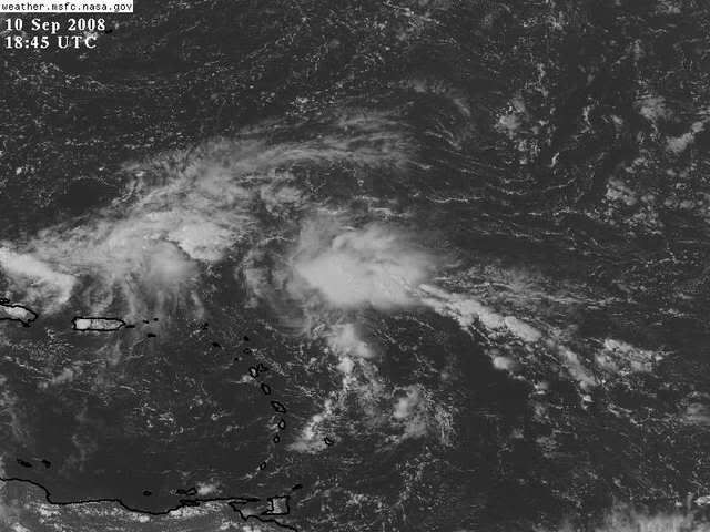
notice the streamers heading up from the south and se on the visible...Pretty good indication something is trying to establish itself.
0 likes
Re: ATL JOSEPHINE: Remnants - Discussion
I agree, this area bears watching. The environment in the SW Atalantic should be improving as Ike heads further west into the GOM. GEM was hinting at development for the past couple of days, but we'll see if the trough in the east doesn't amplify too much to suck it out to sea. Arae in the Eastern Atlantic also bears watching.
0 likes
-
gatorcane

- S2K Supporter

- Posts: 23499
- Age: 46
- Joined: Sun Mar 13, 2005 3:54 pm
- Location: Boca Raton, FL
Re: ATL JOSEPHINE: Remnants - Discussion
I think its likely we will see this area mentioned in the 2:00pm EST TWO....
0 likes
-
jlauderdal
- S2K Supporter
- Posts: 6771
- Joined: Wed May 19, 2004 5:46 am
- Location: NE Fort Lauderdale
- Contact:
Re: ATL JOSEPHINE: Remnants - Discussion
Steve H. wrote:I agree, this area bears watching. The environment in the SW Atalantic should be improving as Ike heads further west into the GOM. GEM was hinting at development for the past couple of days, but we'll see if the trough in the east doesn't amplify too much to suck it out to sea. Arae in the Eastern Atlantic also bears watching.
definitely a bear watch, lets see if the bear awakes due to a higher level of interest this afternoon

0 likes
-
gatorcane
- S2K Supporter
- Posts: 23499
- Age: 46
- Joined: Sun Mar 13, 2005 3:54 pm
- Location: Boca Raton, FL
Re: ATL JOSEPHINE: Remnants - Discussion
We see UL divergence and vorticity near this area. No low-level convergence yet:


0 likes

-
Blown Away

- S2K Supporter
- Posts: 9863
- Joined: Wed May 26, 2004 6:17 am
Re: ATL JOSEPHINE: Remnants - Discussion
Think the NHC gives it a chance at 2pm?? Code yellow maybe?
0 likes
-
GeneratorPower

- S2K Supporter
- Posts: 1648
- Age: 44
- Joined: Sun Dec 18, 2005 11:48 pm
- Location: Huntsville, AL
-
gatorcane
- S2K Supporter
- Posts: 23499
- Age: 46
- Joined: Sun Mar 13, 2005 3:54 pm
- Location: Boca Raton, FL
No mention yet:
000
ABNT20 KNHC 101756
TWOAT
TROPICAL WEATHER OUTLOOK
NWS TPC/NATIONAL HURRICANE CENTER MIAMI FL
200 PM EDT WED SEP 10 2008
FOR THE NORTH ATLANTIC...CARIBBEAN SEA AND THE GULF OF MEXICO...
THE NATIONAL HURRICANE CENTER IS ISSUING ADVISORIES ON HURRICANE
IKE...LOCATED OVER THE SOUTHEASTERN GULF OF MEXICO ABOUT 395 MILES
SOUTH-SOUTHEAST OF THE MOUTH OF THE MISSISSIPPI RIVER.
ELSEWHERE...TROPICAL CYCLONE FORMATION IS NOT EXPECTED DURING THE
NEXT 48 HOURS.
$$
FORECASTER FRANKLIN
0 likes
-
jlauderdal
- S2K Supporter
- Posts: 6771
- Joined: Wed May 19, 2004 5:46 am
- Location: NE Fort Lauderdale
- Contact:
Re:
gatorcane wrote:No mention yet:
000
ABNT20 KNHC 101756
TWOAT
TROPICAL WEATHER OUTLOOK
NWS TPC/NATIONAL HURRICANE CENTER MIAMI FL
200 PM EDT WED SEP 10 2008
FOR THE NORTH ATLANTIC...CARIBBEAN SEA AND THE GULF OF MEXICO...
THE NATIONAL HURRICANE CENTER IS ISSUING ADVISORIES ON HURRICANE
IKE...LOCATED OVER THE SOUTHEASTERN GULF OF MEXICO ABOUT 395 MILES
SOUTH-SOUTHEAST OF THE MOUTH OF THE MISSISSIPPI RIVER.
ELSEWHERE...TROPICAL CYCLONE FORMATION IS NOT EXPECTED DURING THE
NEXT 48 HOURS.
$$
FORECASTER FRANKLIN
bear stays asleep, lets see if it can maintain the convection
0 likes
-
Gustywind

- Category 5

- Posts: 12334
- Joined: Mon Sep 03, 2007 7:29 am
- Location: Baie-Mahault, GUADELOUPE
Re: ATL JOSEPHINE: Remnants - Discussion
Blown_away wrote::uarrow:
Think the NHC gives it a chance at 2pm?? Code yellow maybe?
I don't know for the NHC but man our PRO MET of Meteo France do not play with that and waste their time and i understand them...as St Marteen and St Barth are in yellow alert since 12am for a risk of strong showers and thunderstorms beginning tonight and extending tommrow. So given the thread i guess that this perturbed area is ex Josephine guys?
0 likes
-
gatorcane
- S2K Supporter
- Posts: 23499
- Age: 46
- Joined: Sun Mar 13, 2005 3:54 pm
- Location: Boca Raton, FL
Re: ATL JOSEPHINE: Remnants - Discussion
I have to say I'm a bit surprised NHC didn't at least give this area a yellow code....for the time being.
I have seen plenty of worse looking areas this season that were stamped with yellow. At any rate, I'm pretty confident it will be mentioned at the 8pm EST TWO. It continues to build convection this afternoon

I have seen plenty of worse looking areas this season that were stamped with yellow. At any rate, I'm pretty confident it will be mentioned at the 8pm EST TWO. It continues to build convection this afternoon
0 likes
-
Gustywind
- Category 5
- Posts: 12334
- Joined: Mon Sep 03, 2007 7:29 am
- Location: Baie-Mahault, GUADELOUPE
http://www.meteo.fr/temps/domtom/antill ... Tagant.jpg
000
AXNT20 KNHC 101802
TWDAT
TROPICAL WEATHER DISCUSSION
NWS TPC/NATIONAL HURRICANE CENTER MIAMI FL
205 PM EDT WED SEP 10 2008
TROPICAL WEATHER DISCUSSION FOR NORTH AMERICA...CENTRAL
AMERICA...GULF OF MEXICO...CARIBBEAN SEA...NORTHERN SECTIONS
OF SOUTH AMERICA...AND ATLANTIC OCEAN TO THE AFRICAN COAST
FROM THE EQUATOR TO 32N. THE FOLLOWING INFORMATION IS BASED
ON SATELLITE IMAGERY...METEOROLOGICAL ANALYSIS...WEATHER
OBSERVATIONS...AND RADAR.
BASED ON 1200 UTC SURFACE ANALYSIS AND SATELLITE IMAGERY
THROUGH 1715 UTC.
A SURFACE TROUGH... THE REMNANTS OF T.S.JOSEPHINE... IS E OF THE LEEWARD ISLANDS ALONG 21N55W 13N57W. SCATTERED MODERATE TO ISOLATED STRONG
CONVECTION IS W OF THE WAVE AXIS FROM 19N-22N BETWEEN 55W-60W.
0 likes
-
jlauderdal
- S2K Supporter
- Posts: 6771
- Joined: Wed May 19, 2004 5:46 am
- Location: NE Fort Lauderdale
- Contact:
Re: ATL JOSEPHINE: Remnants - Discussion
miami nws not real excited about it
LONG TERM...SATURDAY THROUGH WEDNESDAY
GFS SHOWS A LOW LVL FEATURE
JUST NW OF PUERTO RICO AND ALTHOUGH LARGE AMOUNT OF MOISTURE IS
INDICATE BY WATER VAPOR IMAGES, NEITHER SFC NOR 850 MB ANALYSIS
DEPICTS ANYTHING OVER THAT AREA. GFS BRINGS THIS LOW LVL
LOW/TROUGH WEST TO CENTRAL BAHAMAS FRI NIGHT AND TO THE FLORIDA
STRAITS SAT NIGHT AND SO IT SHOWS A SLIGHT INCREASE IN THE CHANCES
FOR RAIN OVER MAINLY ERN SECTIONS SATURDAY. OTHER THAN
THIS...MOSTLY SEASONAL CONDITIONS ARE EXPECTED WITH MOSTLY ISOLD
TO LOW SCT POPS.
0 likes

Who is online
Users browsing this forum: No registered users and 29 guests