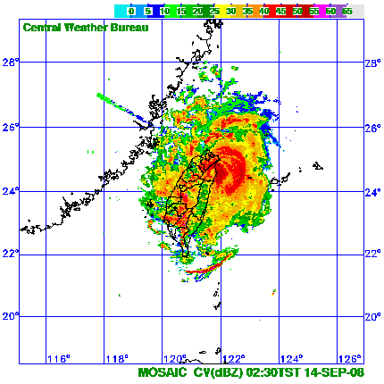
Greatings from eyewall city, Taiwan.
It's been rampaging for over 3 hours now and we managed to find shelter in the women's toilets at the port facility (luckily no screams when we burst in with our cameras.) Judging from radar we're in the northern eyewall and it's been FIERCE.
Power is still on so managed to get some awesome video. I also managed to record a gust hand held of 71mph which nearly blew me off my feet. I recorded a pressure of 966hPa which I believe to be reasonabley accurate.
WPAC SINLAKU: Severe Tropical Storm - Discussion
Moderator: S2k Moderators
-
Typhoon Hunter
- WesternPacificWeather.com

- Posts: 1215
- Age: 40
- Joined: Wed Oct 11, 2006 11:37 am
- Location: Hong Kong
- Contact:

Re: WPAC SINLAKU: Typhoon - Discussion
Typhoon Hunter wrote:Greatings from eyewall city, Taiwan.
It's been rampaging for over 3 hours now and we managed to find shelter in the women's toilets at the port facility (luckily no screams when we burst in with our cameras.) Judging from radar we're in the northern eyewall and it's been FIERCE.
Power is still on so managed to get some awesome video. I also managed to record a gust hand held of 71mph which nearly blew me off my feet. I recorded a pressure of 966hPa which I believe to be reasonabley accurate.
It didn't go straight NW, but turned due west making landfall SE of Ilan City. CWB is expecting it to loop over Ilan for the coming few hours, so be careful!!
Official SLP from Ilan City at 18Z was 972.7 hPa, yours could be justified
0 likes
-
P.K.

- Professional-Met

- Posts: 5149
- Joined: Thu Sep 23, 2004 5:57 pm
- Location: Watford, England
- Contact:
Re: WPAC SINLAKU: Typhoon - Discussion
WTPQ20 RJTD 131800
RSMC TROPICAL CYCLONE ADVISORY
NAME TY 0813 SINLAKU (0813)
ANALYSIS
PSTN 131800UTC 24.7N 121.9E FAIR
MOVE WNW SLOWLY
PRES 960HPA
MXWD 075KT
GUST 105KT
50KT 110NM SOUTHEAST 80NM NORTHWEST
30KT 240NM SOUTH 180NM NORTH
FORECAST
24HF 141800UTC 26.8N 122.0E 85NM 70%
MOVE NNE 06KT
PRES 960HPA
MXWD 075KT
GUST 105KT
48HF 151800UTC 28.5N 125.8E 160NM 70%
MOVE ENE 09KT
PRES 960HPA
MXWD 075KT
GUST 105KT
72HF 161800UTC 29.6N 130.4E 220NM 70%
MOVE ENE 10KT
PRES 960HPA
MXWD 075KT
GUST 105KT =
0 likes


-
Typhoon Hunter
- WesternPacificWeather.com
- Posts: 1215
- Age: 40
- Joined: Wed Oct 11, 2006 11:37 am
- Location: Hong Kong
- Contact:
Re: WPAC SINLAKU: Typhoon - Discussion
The worst of the eyewall finished around 4am so we head back to the hotel to crash out exhausted. We get the best possible pictures we could given the lighting situation. The video should be awesome and I'll try and get that online ASAP. We're heading back to Taipei this afternoon along the NE coastal road so will be interesting to see the effects of the storm along there.

0 likes


WTPQ20 RJTD 140300
RSMC TROPICAL CYCLONE ADVISORY
NAME STS 0813 SINLAKU (0813) DOWNGRADED FROM TY
ANALYSIS
PSTN 140300UTC 25.3N 121.7E FAIR
MOVE N SLOWLY
PRES 980HPA
MXWD 060KT
GUST 085KT
50KT 90NM SOUTHEAST 60NM NORTHWEST
30KT 210NM SOUTH 150NM NORTH
FORECAST
24HF 150300UTC 27.1N 122.3E 85NM 70%
MOVE NE SLOWLY
PRES 980HPA
MXWD 055KT
GUST 080KT
45HF 160000UTC 28.2N 124.5E 160NM 70%
MOVE ENE 06KT
PRES 975HPA
MXWD 060KT
GUST 085KT
69HF 170000UTC 29.5N 129.3E 250NM 70%
MOVE ENE 11KT
PRES 970HPA
MXWD 065KT
GUST 095KT =
0 likes
WTPQ20 RJTD 140600
RSMC TROPICAL CYCLONE ADVISORY
NAME STS 0813 SINLAKU (0813)
ANALYSIS
PSTN 140600UTC 25.3N 121.3E FAIR
MOVE NNW SLOWLY
PRES 985HPA
MXWD 060KT
GUST 085KT
50KT 40NM
30KT 210NM SOUTH 150NM NORTH
FORECAST
24HF 150600UTC 27.7N 122.4E 85NM 70%
MOVE NE 08KT
PRES 980HPA
MXWD 065KT
GUST 095KT
48HF 160600UTC 28.8N 126.0E 160NM 70%
MOVE ENE 08KT
PRES 975HPA
MXWD 070KT
GUST 100KT
72HF 170600UTC 29.7N 129.9E 220NM 70%
MOVE ENE 09KT
PRES 960HPA
MXWD 075KT
GUST 105KT =
0 likes
WTPQ20 RJTD 140900
RSMC TROPICAL CYCLONE ADVISORY
NAME STS 0813 SINLAKU (0813)
ANALYSIS
PSTN 140900UTC 25.3N 121.0E FAIR
MOVE WNW SLOWLY
PRES 985HPA
MXWD 060KT
GUST 085KT
50KT 70NM
30KT 210NM SOUTH 150NM NORTH
FORECAST
24HF 150900UTC 27.7N 122.5E 85NM 70%
MOVE NE 09KT
PRES 980HPA
MXWD 065KT
GUST 095KT
45HF 160600UTC 28.8N 126.0E 160NM 70%
MOVE ENE 08KT
PRES 975HPA
MXWD 070KT
GUST 100KT
69HF 170600UTC 29.7N 129.9E 220NM 70%
MOVE ENE 09KT
PRES 960HPA
MXWD 075KT
GUST 105KT =
0 likes
WTPQ20 RJTD 141200
RSMC TROPICAL CYCLONE ADVISORY
NAME STS 0813 SINLAKU (0813)
ANALYSIS
PSTN 141200UTC 25.3N 121.0E FAIR
MOVE ALMOST STATIONARY
PRES 985HPA
MXWD 060KT
GUST 085KT
50KT 60NM
30KT 210NM SOUTH 150NM NORTH
FORECAST
24HF 151200UTC 27.4N 122.4E 85NM 70%
MOVE NE 08KT
PRES 980HPA
MXWD 065KT
GUST 095KT
48HF 161200UTC 28.6N 126.0E 160NM 70%
MOVE ENE 08KT
PRES 970HPA
MXWD 070KT
GUST 100KT
72HF 171200UTC 29.3N 130.0E 220NM 70%
MOVE E 09KT
PRES 965HPA
MXWD 075KT
GUST 105KT =
0 likes

Re: WPAC SINLAKU: Typhoon - Discussion
Near my in-law's hometown of Fengyuan a good-sized bridge had a section wash out, sending three cars into the raging river. They got over 1300mm of rain so far with over 700mm expected tonight. Incredible amount of flooding everywhere.
0 likes


Re: WPAC SINLAKU: Typhoon - Discussion
Man, that's some seriously heavy duty rainfall!tim_in_ga wrote:Near my in-law's hometown of Fengyuan a good-sized bridge had a section wash out, sending three cars into the raging river. They got over 1300mm of rain so far with over 700mm expected tonight. Incredible amount of flooding everywhere.
0 likes
From CWB:
12日0時至14日21時出現較大累積雨量如下:嘉義縣石磐龍1305毫米、 苗栗縣泰安
1151毫米、台中縣雪嶺1084毫米、新竹縣鳥嘴山1083毫米、宜蘭縣池端1055毫
米、桃園縣巴陵999毫米、台北縣福山913毫米、台北市明德898毫米、 南投縣神木村
863毫米、高雄縣御油山751毫米、台南縣關山628毫米。
From 11/16z to 14/13z, total rainfall accumulations:
Chiayi County: 1305 mm (51 in)
Miaoli County (Tai-an Township): 1151 mm (45 in)
Taichung County: 1084 mm (42.6 in)
Hsinchu County (Beak Hill): 1083 mm (42.6 in)
Yilan County: 1055 mm (41.5 in)
Taoyuan County: 999 mm (39 in)
Taipei County (Fushan): 913 mm (36 in)
Taipei City (Mingde): 898 mm (35 in)
Nantou County (Shenmu Village): 863 mm (34 in)
Kaohsiung County: 751 mm (30 in)
Tainan County (Mt Guan): 628 mm (25 in)
0 likes
WTPQ20 RJTD 141500
RSMC TROPICAL CYCLONE ADVISORY
NAME STS 0813 SINLAKU (0813)
ANALYSIS
PSTN 141500UTC 25.5N 120.9E FAIR
MOVE ALMOST STATIONARY
PRES 985HPA
MXWD 060KT
GUST 085KT
50KT 60NM
30KT 210NM SOUTH 150NM NORTH
FORECAST
24HF 151500UTC 27.2N 122.3E 85NM 70%
MOVE NE 08KT
PRES 980HPA
MXWD 065KT
GUST 095KT
45HF 161200UTC 28.6N 126.0E 160NM 70%
MOVE ENE 08KT
PRES 970HPA
MXWD 070KT
GUST 100KT
69HF 171200UTC 29.3N 130.0E 220NM 70%
MOVE E 09KT
PRES 965HPA
MXWD 075KT
GUST 105KT =
0 likes


WTPQ20 RJTD 150000
RSMC TROPICAL CYCLONE ADVISORY
NAME STS 0813 SINLAKU (0813)
ANALYSIS
PSTN 150000UTC 26.2N 121.0E FAIR
MOVE N SLOWLY
PRES 980HPA
MXWD 060KT
GUST 085KT
50KT 60NM
30KT 180NM SOUTHEAST 150NM NORTHWEST
FORECAST
24HF 160000UTC 27.4N 123.5E 85NM 70%
MOVE ENE 08KT
PRES 975HPA
MXWD 065KT
GUST 095KT
48HF 170000UTC 28.5N 126.5E 160NM 70%
MOVE ENE 07KT
PRES 975HPA
MXWD 070KT
GUST 100KT
72HF 180000UTC 30.2N 129.7E 220NM 70%
MOVE ENE 08KT
PRES 970HPA
MXWD 075KT
GUST 105KT =
0 likes
Who is online
Users browsing this forum: No registered users and 83 guests