ATL INVEST 91L: Discussion

Moderator: S2k Moderators

Message
Author
User avatar
gatorcane
S2K Supporter
S2K Supporter
Posts: 23499
Age: 46
Joined: Sun Mar 13, 2005 3:54 pm
Location: Boca Raton, FL

#61 Postby gatorcane » Thu Sep 11, 2008 3:07 pm

91L up on NHC site. Floater 1

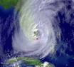
Convection starting to fire now over the MLC

Image

http://www.nhc.noaa.gov/satellite.shtml
0 likes   

HURRICANELONNY
Category 5
Category 5
Posts: 1381
Joined: Wed May 07, 2003 6:48 am
Location: HOLLYWOOD.FL

Re: ATL: INVEST 91L - Discussion

#62 Postby HURRICANELONNY » Thu Sep 11, 2008 3:17 pm

I don't think the sat is right on the NHC site. The invest on the NRL site shows a different 91L.
http://www.nrlmry.navy.mil/tc_pages/tc_home.html
0 likes   

User avatar
HurricaneFreak
Tropical Depression
Tropical Depression
Posts: 80
Joined: Sat Sep 06, 2008 11:37 pm
Location: Boca Raton,Florida

#63 Postby HurricaneFreak » Thu Sep 11, 2008 3:42 pm

:eek: :eek: :eek:
THRE IS NOW AND OFFICIAL CODE YELLOW FOR REMNANTS OF EX JOSEY CHECK THIS NHC SITE LINK
http://www.nhc.noaa.gov/gtwo_atl.shtml
FOR THE NORTH ATLANTIC...CARIBBEAN SEA AND THE GULF OF MEXICO...

THE NATIONAL HURRICANE CENTER IS ISSUING ADVISORIES ON LARGE
HURRICANE IKE...LOCATED ABOUT 440 MILES EAST-SOUTHEAST OF CORPUS
CHRISTI TEXAS AND ABOUT 470 MILES EAST-SOUTHEAST OF GALVESTON
TEXAS.

1. AN AREA OF DISTURBED WEATHER...INCLUDING SOME OF THE REMNANTS OF
TROPICAL STORM JOSEPHINE...HAS DEVELOPED ABOUT 350 MILES EAST OF
THE SOUTHEASTERN BAHAMAS. ENVIRONMENTAL CONDITIONS ARE MARGINALLY
CONDUCIVE FOR SOME ADDITIONAL DEVELOPMENT OF THE SYSTEM TO OCCUR AS
IT MOVES SLOWLY WEST-NORTHWESTWARD OVER THE NEXT COUPLE OF DAYS.

ELSEWHERE...TROPICAL CYCLONE FORMATION IS NOT EXPECTED DURING THE
NEXT 48 HOURS.
0 likes   

User avatar
HurricaneFreak
Tropical Depression
Tropical Depression
Posts: 80
Joined: Sat Sep 06, 2008 11:37 pm
Location: Boca Raton,Florida

Re: ATL: INVEST 91L - Discussion

#64 Postby HurricaneFreak » Thu Sep 11, 2008 3:46 pm

Image
0 likes   

User avatar
HurricaneFreak
Tropical Depression
Tropical Depression
Posts: 80
Joined: Sat Sep 06, 2008 11:37 pm
Location: Boca Raton,Florida

#65 Postby HurricaneFreak » Thu Sep 11, 2008 3:57 pm

You know Floridians should start worrying about this invest 91 now because as Ike moves away this could form into something.So Florida dont get so happy that Ike missed us and went to Cuba cause maybe invest 91l will take that job Ike was suppose to do to Fl.OMG storms jusst keep on coming one after the next.Not one quiet week lol.
0 likes   

User avatar
gatorcane
S2K Supporter
S2K Supporter
Posts: 23499
Age: 46
Joined: Sun Mar 13, 2005 3:54 pm
Location: Boca Raton, FL

Re:

#66 Postby gatorcane » Thu Sep 11, 2008 4:07 pm

HurricaneFreak wrote:You know Floridians should start worrying about this invest 91 now because as Ike moves away this could form into something.So Florida dont get so happy that Ike missed us and went to Cuba cause maybe invest 91l will take that job Ike was suppose to do to Fl.OMG storms jusst keep on coming one after the next.Not one quiet week lol.


well should 91L develop into Kyle and threaten Florida, I would think residents would be in utter shock. I mean how many can Florida dodge this season without taking a hit at some point (Fay did hit SW Florida directly and caused major flooding to central Florida albeit it didn't come with the destructive winds) and was it just not last weekend that Southern Florida residents were doing what they could to get CAT 4 Ike's track shifted well south?

Still lots of IFs with this invest at this point....all the attention is on Ike as it should be, but should this invest develop into something more as it has a chance to, attention will quickly shift back to this
0 likes   

tina25
Tropical Depression
Tropical Depression
Posts: 62
Joined: Mon Sep 01, 2008 10:53 pm
Location: NYC

#67 Postby tina25 » Thu Sep 11, 2008 4:15 pm

I'm in SWFL and the local weatherman on NBC made it sound like it will be nothing more than a cluster of storms and it will probably bring us some showers next week.
0 likes   

Dean4Storms
S2K Supporter
S2K Supporter
Posts: 6355
Age: 61
Joined: Sun Aug 31, 2003 1:01 pm
Location: Miramar Bch. FL

#68 Postby Dean4Storms » Thu Sep 11, 2008 4:43 pm

If it keeps up with the increase in convection it will have a chance, persistance here is the key. If it is still firing off convection and getting organized come Friday we might have another player here.
0 likes   

User avatar
gatorcane
S2K Supporter
S2K Supporter
Posts: 23499
Age: 46
Joined: Sun Mar 13, 2005 3:54 pm
Location: Boca Raton, FL

#69 Postby gatorcane » Thu Sep 11, 2008 4:50 pm

well as expected convection right over the MLC continues this evening......

looks like it is organizing to me:

Image
Last edited by gatorcane on Thu Sep 11, 2008 4:51 pm, edited 1 time in total.
0 likes   

User avatar
gatorcane
S2K Supporter
S2K Supporter
Posts: 23499
Age: 46
Joined: Sun Mar 13, 2005 3:54 pm
Location: Boca Raton, FL

#70 Postby gatorcane » Thu Sep 11, 2008 4:50 pm

Image
0 likes   

jinftl
Category 5
Category 5
Posts: 4312
Joined: Tue Aug 31, 2004 4:47 pm
Location: fort lauderdale, fl

Re:

#71 Postby jinftl » Thu Sep 11, 2008 4:55 pm

close enough to ike that it may be getting shear from ike's circulation? infuence track too?

gatorcane wrote:Image
0 likes   

User avatar
HurricaneFreak
Tropical Depression
Tropical Depression
Posts: 80
Joined: Sat Sep 06, 2008 11:37 pm
Location: Boca Raton,Florida

Re: Re:

#72 Postby HurricaneFreak » Thu Sep 11, 2008 5:18 pm

jinftl wrote:close enough to ike that it may be getting shear from ike's circulation? infuence track too?

gatorcane wrote:Image

As if now Ike may be affecting Invest 91L maybe thats why this invest 91L is having a little trouble tring to get its act to gether but its getting thre.And once Ike moves West more...this flare of convection could increase maybe to a depression at the end of this week.
0 likes   

User avatar
fci
S2K Supporter
S2K Supporter
Posts: 3296
Joined: Tue Sep 14, 2004 10:29 am
Location: Lake Worth, FL

#73 Postby fci » Thu Sep 11, 2008 5:29 pm

I don't see anything impressive here, folks.
Models I am seeing on Weather Underground; BAM's, etc.. mostly show a system going NW.
If it does go W, outflow from the monster in GOM will make it very hard to develop.
After the "fast break" of the past few weeks, this is nothing to me until it ever develops.
Until then, only a passing interest.

All of course, my opinion.

Personal Forecast Disclaimer:
The posts in this forum are NOT official forecast and should not be used as such. They are just the opinion of the poster and may or may not be backed by sound meteorological data. They are NOT endorsed by any professional institution or storm2k.org. For official information, please refer to the NHC and NWS products.
0 likes   

User avatar
HURAKAN
Professional-Met
Professional-Met
Posts: 46086
Age: 37
Joined: Thu May 20, 2004 4:34 pm
Location: Key West, FL
Contact:

#74 Postby HURAKAN » Thu Sep 11, 2008 5:40 pm

0 likes   

User avatar
HurricaneFreak
Tropical Depression
Tropical Depression
Posts: 80
Joined: Sat Sep 06, 2008 11:37 pm
Location: Boca Raton,Florida

#75 Postby HurricaneFreak » Thu Sep 11, 2008 5:52 pm

Uhh bad news so Invest 91L IS FORMING but thre is also a impressive tropical wave about to come off the african coast and thre is a lot of showers in the mid atlantic too.
http://www.weather.com/maps/maptype/sat ... mated.html
0 likes   

Sihara
Tropical Storm
Tropical Storm
Posts: 137
Joined: Wed Jul 16, 2008 8:39 pm
Location: St. Petersburg, FL

Re:

#76 Postby Sihara » Thu Sep 11, 2008 5:58 pm

tina25 wrote:I'm in SWFL and the local weatherman on NBC made it sound like it will be nothing more than a cluster of storms


Uh-oh. Ick. Anyone remember that "cluster of thunderstorms" in March of '93? Kind of a bumpy ride, that was.

So maybe right now it doesn't look like much, but it least deserves a bear watch (someone go wake up the bear).
0 likes   

User avatar
Vortex
S2K Supporter
S2K Supporter
Posts: 4644
Age: 52
Joined: Fri Aug 01, 2003 9:34 pm
Location: Hilton Head, SC

Re: ATL: INVEST 91L - Discussion

#77 Postby Vortex » Thu Sep 11, 2008 6:05 pm

91 coming to life tonight..certainly the convection is firing right over the center.
0 likes   

jlauderdal
S2K Supporter
S2K Supporter
Posts: 6771
Joined: Wed May 19, 2004 5:46 am
Location: NE Fort Lauderdale
Contact:

Re: Re:

#78 Postby jlauderdal » Thu Sep 11, 2008 6:07 pm

Sihara wrote:
tina25 wrote:I'm in SWFL and the local weatherman on NBC made it sound like it will be nothing more than a cluster of storms


Uh-oh. Ick. Anyone remember that "cluster of thunderstorms" in March of '93? Kind of a bumpy ride, that was.

So maybe right now it doesn't look like much, but it least deserves a bear watch (someone go wake up the bear).


it was awoken earlier today but here it is again

Image
0 likes   

User avatar
HurricaneFreak
Tropical Depression
Tropical Depression
Posts: 80
Joined: Sat Sep 06, 2008 11:37 pm
Location: Boca Raton,Florida

Re: ATL: INVEST 91L - Discussion

#79 Postby HurricaneFreak » Thu Sep 11, 2008 6:08 pm

Vortex wrote:91 coming to life tonight..certainly the convection is firing right over the center.

I totally agree cause I see cluster and blobs of storms forming around the center which is evidenc of convection!
0 likes   

User avatar
HURAKAN
Professional-Met
Professional-Met
Posts: 46086
Age: 37
Joined: Thu May 20, 2004 4:34 pm
Location: Key West, FL
Contact:

#80 Postby HURAKAN » Thu Sep 11, 2008 6:15 pm

If this becomes Kyle I hope it's not as long-lasting as it was in 2002.
0 likes   


Return to “2008”

Who is online

Users browsing this forum: No registered users and 106 guests