
ATL Ex. INVEST 92L: Discussion
Moderator: S2k Moderators
-
Blown Away

- S2K Supporter

- Posts: 9863
- Joined: Wed May 26, 2004 6:17 am
Re: ATL INVEST 92L: Discussion

IR Loop: http://www.ssd.noaa.gov/goes/flt/t2/loop-avn.html
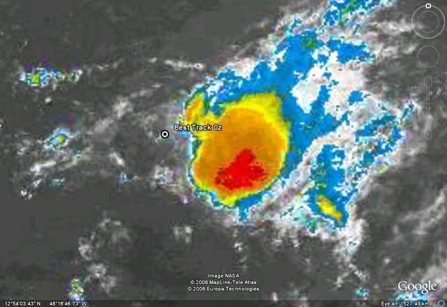
92L still has a healthy LLC, you can see the rotation on IR loop. A small burst of convection along the SE side of the LLC, but most of the deep convection is removed to the SE.
0 likes

-
MiamiensisWx
Re: ATL INVEST 92L: Discussion
Stormcenter wrote:Thank goodness it's September 13th and not August 13th.
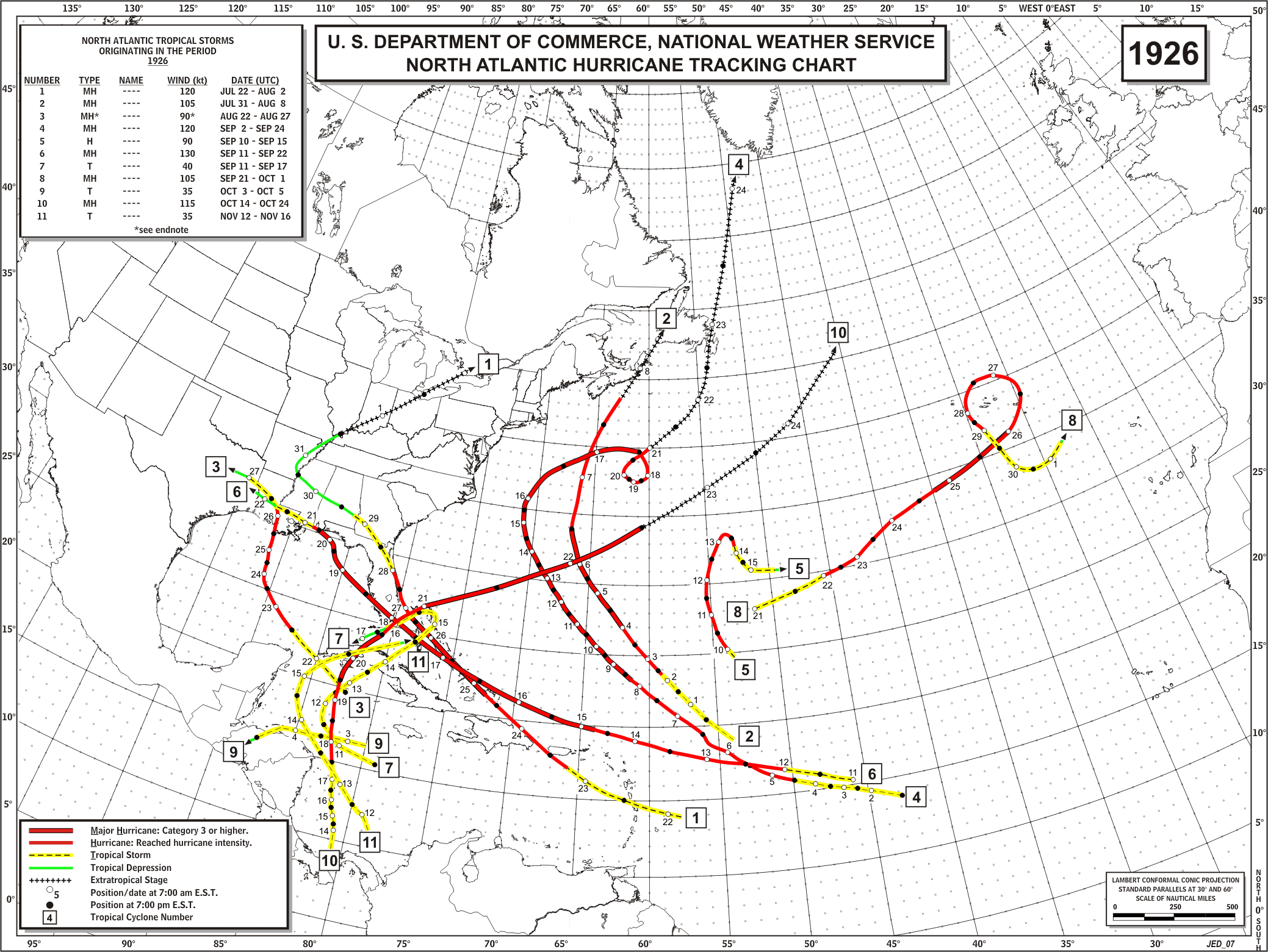
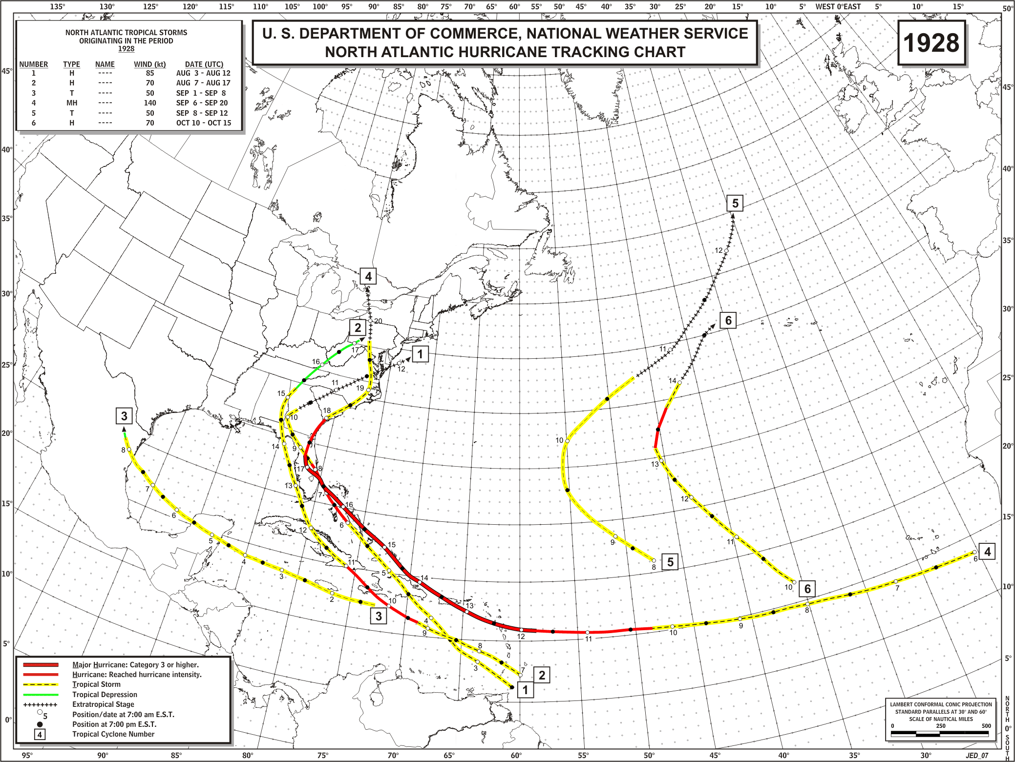
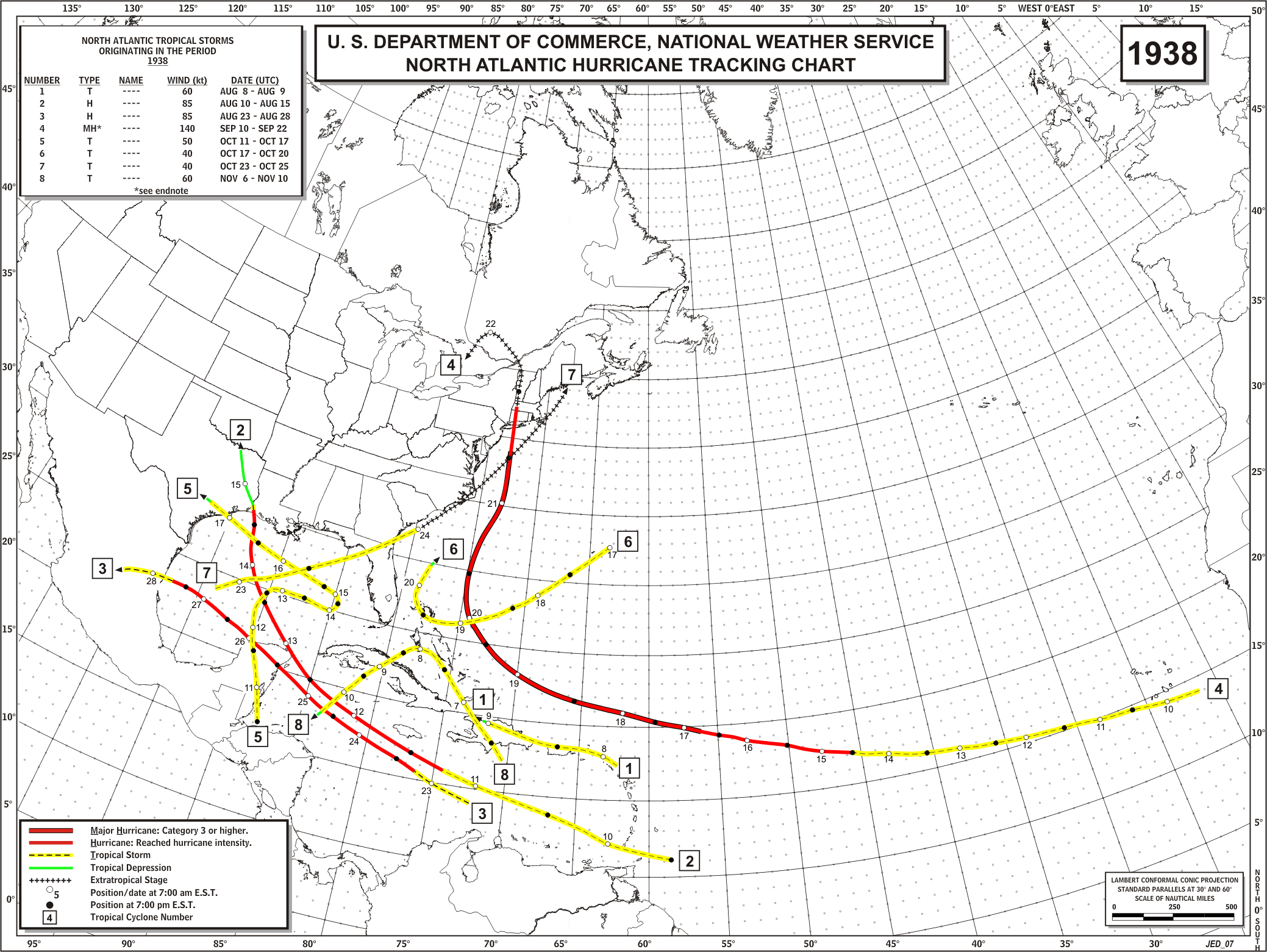
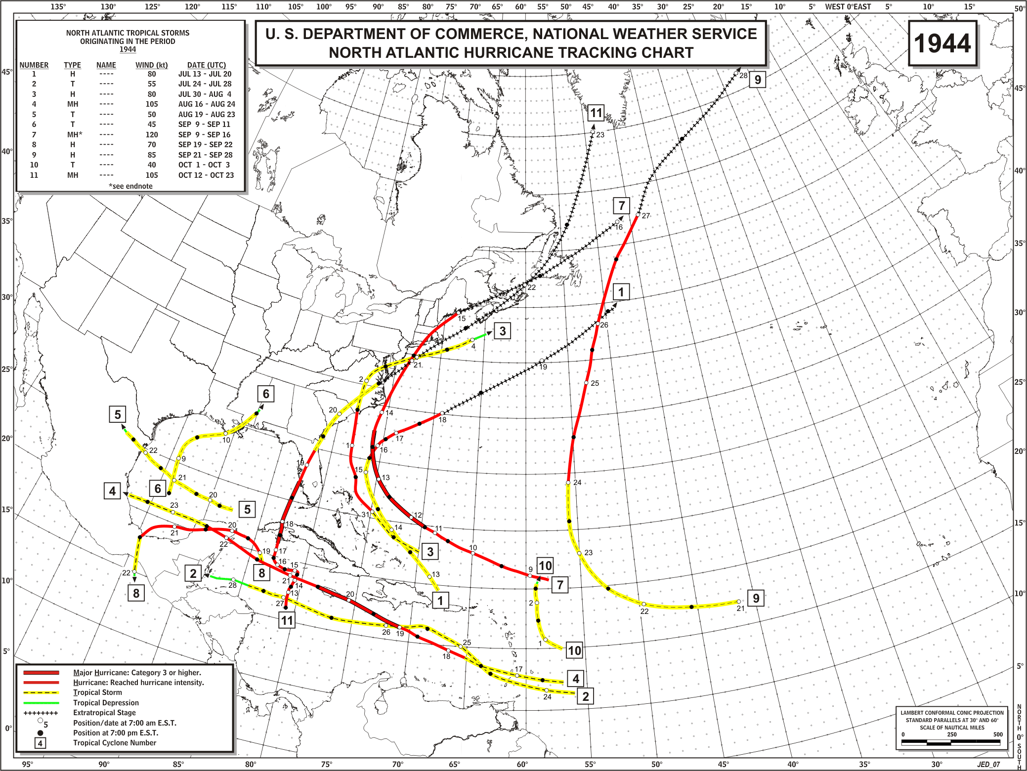
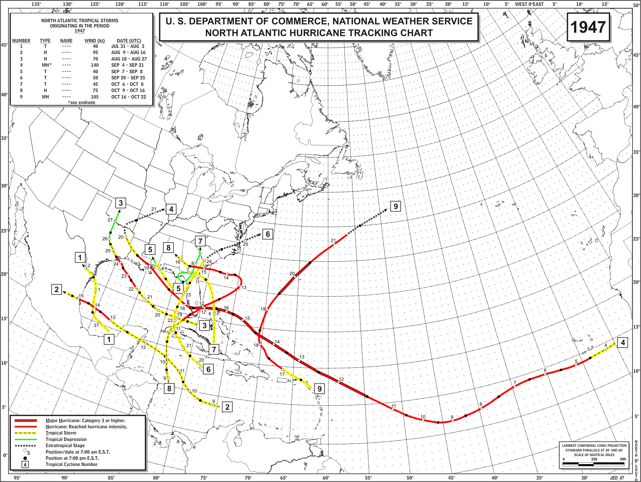
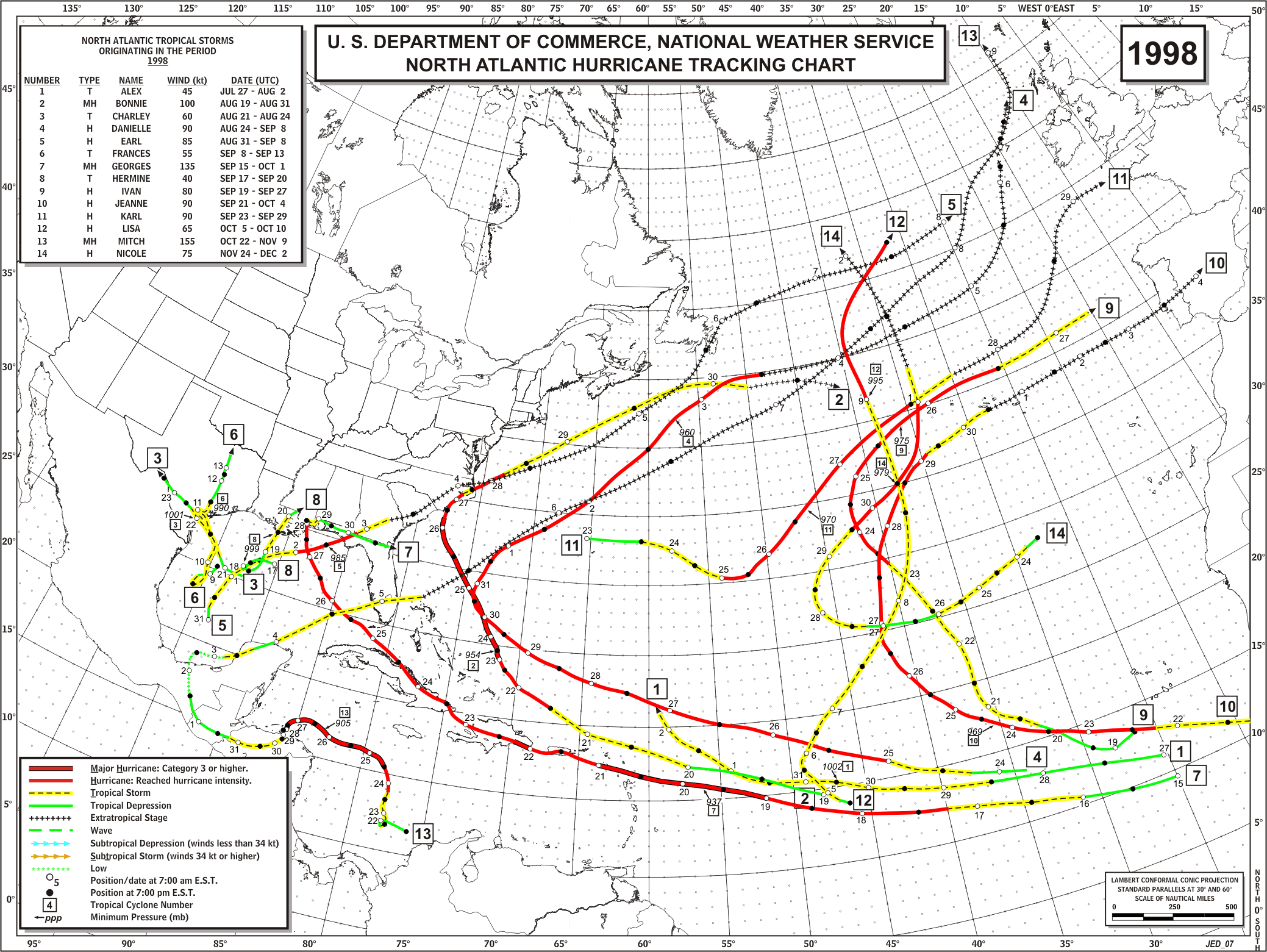
Numerous Cape Verde TCs have formed on this date (or during the succeeding days); in fact, several examples were active on this date (or later) and affected the CONUS, including 1926 #6, 1928 #4, 1938 #4, 1944 #10, 1947 #4, Georges 1998, Ivan 2004, and others. The risk of landfalling Cape Verde TCs in the CONUS decreases substantially after September 20, so we have one remaining week prior to the annual reduction of the probabilities of a "long track" hit. It is noted that Georges affected Mississippi on September 28. Regardless, 92L will likely not develop because of the strong UL wind vectors (and a northwesterly jet max) from an adjacent TUTT to the NNW.
0 likes
Re: ATL INVEST 92L: Discussion
Well let it lose that convection burst first before writing it off.
0 likes
-
Blown Away
- S2K Supporter
- Posts: 9863
- Joined: Wed May 26, 2004 6:17 am
Re: ATL INVEST 92L: Discussion
MiamiensisWx wrote:Stormcenter wrote:Thank goodness it's September 13th and not August 13th.
Numerous Cape Verde TCs have formed on this date (or during the succeeding days); in fact, several examples were active on this date (or later) and affected the CONUS, including 1926 #6, 1928 #4, 1938 #4, 1944 #10, 1947 #4, Georges 1998, Ivan 2004, and others. The risk of landfalling Cape Verde TCs in the CONUS decreases substantially after September 20, so we have one remaining week prior to the annual reduction of the probabilities of a "long track" hit. It is noted that Georges affected Mississippi on September 28. Regardless, 92L will likely not develop because of the strong UL wind vectors (and a northwesterly jet max) from an adjacent TUTT to the NNW.
Hebert Box for all the SFL/Keys storms.
0 likes
-
HurricaneFreak
- Tropical Depression

- Posts: 80
- Joined: Sat Sep 06, 2008 11:37 pm
- Location: Boca Raton,Florida
Re: ATL INVEST 92L: Discussion
Okay well it seems the shear is keeping the conection to the east of the LLC but shear is expected to decrese a little bit and if the LLC doesn't move away so fast then the convection could have a chance to wrap around the circulation if convection lives for next few days.Then if it goes under the ridge it could pass into the "Herbert Box" which is a few hundred miles WNW of Invest 92L then it would not be a fish storm.It could start to strengthen and then move on somewhere to northern Cuba,or east coast of Florida.Thats my thought of what could happen IF the invest 92L keeps a strong convection status and survives shear.
A lot of IFS in this situation.
A lot of IFS in this situation.
0 likes
-
bob rulz
- Category 5

- Posts: 1667
- Age: 34
- Joined: Sat Jan 28, 2006 7:30 pm
- Location: Salt Lake City, Utah
Re: ATL INVEST 92L: Discussion
MiamiensisWx wrote:Stormcenter wrote:Thank goodness it's September 13th and not August 13th.
Numerous Cape Verde TCs have formed on this date (or during the succeeding days); in fact, several examples were active on this date (or later) and affected the CONUS, including 1926 #6, 1928 #4, 1938 #4, 1944 #10, 1947 #4, Georges 1998, Ivan 2004, and others. The risk of landfalling Cape Verde TCs in the CONUS decreases substantially after September 20, so we have one remaining week prior to the annual reduction of the probabilities of a "long track" hit. It is noted that Georges affected Mississippi on September 28. Regardless, 92L will likely not develop because of the strong UL wind vectors (and a northwesterly jet max) from an adjacent TUTT to the NNW.
Wow, I hope we never see another storm that takes the path of that 1947 #4!
NHC doesn't seem too enthusiastic about this disturbance.
0 likes

-
cycloneye

- Admin

- Posts: 139144
- Age: 67
- Joined: Thu Oct 10, 2002 10:54 am
- Location: San Juan, Puerto Rico
Re: ATL INVEST 92L: Discussion
Nothing new:
ABNT20 KNHC 141143
TWOAT
TROPICAL WEATHER OUTLOOK
NWS TPC/NATIONAL HURRICANE CENTER MIAMI FL
800 AM EDT SUN SEP 14 2008
FOR THE NORTH ATLANTIC...CARIBBEAN SEA AND THE GULF OF MEXICO...
THE NATIONAL HURRICANE CENTER HAS ISSUED ITS LAST ADVISORY ON
TROPICAL DEPRESSION IKE...WHICH IS CURRENTLY MERGING WITH A FRONTAL
ZONE IN SOUTHEASTERN MISSOURI. FUTURE ADVISORIES ON THE
EXTRATROPICAL REMNANTS OF IKE WILL BE ISSUED BY THE
HYDROMETEOROLOGICAL PREDICTION CENTER IN WASHINGTON DC.
 A TROPICAL WAVE LOCATED ABOUT 800 MILES EAST OF THE LEEWARD ISLANDS
IS PRODUCING DISORGANIZED SHOWER ACTIVITY AS IT MOVES
WEST-NORTHWESTWARD AT ABOUT 15 MPH. SIGNIFICANT DEVELOPMENT OF
THIS SYSTEM DURING THE NEXT COUPLE OF DAYS APPEARS UNLIKELY DUE TO
STRONG UPPER-LEVEL WINDS.
ELSEWHERE...TROPICAL CYCLONE FORMATION IS NOT EXPECTED DURING THE
NEXT 48 HOURS.
$$
FORECASTER BEVEN/FRANKLIN
ABNT20 KNHC 141143
TWOAT
TROPICAL WEATHER OUTLOOK
NWS TPC/NATIONAL HURRICANE CENTER MIAMI FL
800 AM EDT SUN SEP 14 2008
FOR THE NORTH ATLANTIC...CARIBBEAN SEA AND THE GULF OF MEXICO...
THE NATIONAL HURRICANE CENTER HAS ISSUED ITS LAST ADVISORY ON
TROPICAL DEPRESSION IKE...WHICH IS CURRENTLY MERGING WITH A FRONTAL
ZONE IN SOUTHEASTERN MISSOURI. FUTURE ADVISORIES ON THE
EXTRATROPICAL REMNANTS OF IKE WILL BE ISSUED BY THE
HYDROMETEOROLOGICAL PREDICTION CENTER IN WASHINGTON DC.
IS PRODUCING DISORGANIZED SHOWER ACTIVITY AS IT MOVES
WEST-NORTHWESTWARD AT ABOUT 15 MPH. SIGNIFICANT DEVELOPMENT OF
THIS SYSTEM DURING THE NEXT COUPLE OF DAYS APPEARS UNLIKELY DUE TO
STRONG UPPER-LEVEL WINDS.
ELSEWHERE...TROPICAL CYCLONE FORMATION IS NOT EXPECTED DURING THE
NEXT 48 HOURS.
$$
FORECASTER BEVEN/FRANKLIN
0 likes
-
Blown Away
- S2K Supporter
- Posts: 9863
- Joined: Wed May 26, 2004 6:17 am
Re: ATL INVEST 92L: Discussion
The LLC not as visible as yesterday, but is still near 16.5N/50W moving just N of due W. No NW movement like the models show.
0 likes
Re: ATL INVEST 92L: Discussion
I noticed models were wrong on movement too. Big ULL descending down on it. Almost stripped. If it makes it past it might rebound.
0 likes
-
CrazyC83
- Professional-Met

- Posts: 33393
- Joined: Tue Mar 07, 2006 11:57 pm
- Location: Deep South, for the first time!
Re: ATL INVEST 92L: Discussion
Sanibel wrote:I noticed models were wrong on movement too. Big ULL descending down on it. Almost stripped. If it makes it past it might rebound.
It may also develop a new center in the convection...
0 likes
-
MHurricanes

- Tropical Storm

- Posts: 102
- Age: 72
- Joined: Thu Aug 14, 2008 2:05 pm
- Location: Altamonte Springs, FL
- Contact:
Re: ATL INVEST 92L: Discussion
Sanibel wrote:I noticed models were wrong on movement too. Big ULL descending down on it. Almost stripped. If it makes it past it might rebound.
If this holds together, where could we possibly see it (longitude/lattitude) organizing into a tropical depression?
- MHurricanes
0 likes
-
cycloneye
- Admin
- Posts: 139144
- Age: 67
- Joined: Thu Oct 10, 2002 10:54 am
- Location: San Juan, Puerto Rico
Re: ATL INVEST 92L: Discussion
92L has been deactivated.
BEGIN
NHC
invest_DEACTIVATE_al922008.ren
FSTDA
R
U
040
010
0000
200809141336
NONE
NOTIFY=ATRP
END
ftp://ftp.tpc.ncep.noaa.gov/atcf/tcweb/
The thread is moved to Talking Tropics forum.If they reactivate this system as a invest,then the thread will be back at Active Storms forum.
BEGIN
NHC
invest_DEACTIVATE_al922008.ren
FSTDA
R
U
040
010
0000
200809141336
NONE
NOTIFY=ATRP
END
ftp://ftp.tpc.ncep.noaa.gov/atcf/tcweb/
The thread is moved to Talking Tropics forum.If they reactivate this system as a invest,then the thread will be back at Active Storms forum.
0 likes
-
chrisnnavarre
- Category 1

- Posts: 309
- Joined: Fri Oct 03, 2003 5:52 pm
- Contact:
Re: ATL Ex INVEST 92L: Discussion
Sure looks it's still there to me and maybe just a little convection starting to approach the LLC.
0 likes
Who is online
Users browsing this forum: No registered users and 58 guests