WPAC HAGUPIT (PAGASA: Nina): Typhoon - Discussion

Moderator: S2k Moderators

Message
Author
User avatar
HURAKAN
Professional-Met
Professional-Met
Posts: 46086
Age: 37
Joined: Thu May 20, 2004 4:34 pm
Location: Key West, FL
Contact:

Re: WPAC HAGUPIT (PAGASA: Nina): Typhoon - Discussion

#101 Postby HURAKAN » Tue Sep 23, 2008 3:51 pm

Image

Image
0 likes   

User avatar
HURAKAN
Professional-Met
Professional-Met
Posts: 46086
Age: 37
Joined: Thu May 20, 2004 4:34 pm
Location: Key West, FL
Contact:

#102 Postby HURAKAN » Tue Sep 23, 2008 4:18 pm

Image

Image
0 likes   

HurricaneBill
Category 5
Category 5
Posts: 3420
Joined: Sun Apr 11, 2004 5:51 pm
Location: East Longmeadow, MA, USA

Re: WPAC HAGUPIT (PAGASA: Nina): Typhoon - Discussion

#103 Postby HurricaneBill » Tue Sep 23, 2008 4:21 pm

With the eye moving parallel to the coast, a lot of coastal areas will get the eyewall.
0 likes   

User avatar
HURAKAN
Professional-Met
Professional-Met
Posts: 46086
Age: 37
Joined: Thu May 20, 2004 4:34 pm
Location: Key West, FL
Contact:

Re: WPAC HAGUPIT (PAGASA: Nina): Typhoon - Discussion

#104 Postby HURAKAN » Tue Sep 23, 2008 6:00 pm

Image

Landfall.
0 likes   

Dave C
S2K Supporter
S2K Supporter
Posts: 868
Joined: Thu Sep 04, 2003 4:36 pm
Location: Middleboro, Mass.(midway between Cape Cod and Boston)

#105 Postby Dave C » Tue Sep 23, 2008 6:38 pm

The way the coastline is shaped near landfall that would seem to be devastating for surge. Just west of landfall the coastline turns south towards Hainan island. All that water must have been pushed into that area silmilar to Texas when Ike pushed west with flooding many hrs before landfall.
0 likes   

CrazyC83
Professional-Met
Professional-Met
Posts: 33393
Joined: Tue Mar 07, 2006 11:57 pm
Location: Deep South, for the first time!

#106 Postby CrazyC83 » Tue Sep 23, 2008 7:17 pm

Looks to have weakened a bit as the eye was half ashore.
0 likes   

User avatar
wyq614
Category 3
Category 3
Posts: 827
Age: 35
Joined: Sun Dec 02, 2007 12:32 am
Location: Beijing, China (Hometown: Qingdao, China, 36.06N 120.43E)
Contact:

#107 Postby wyq614 » Tue Sep 23, 2008 8:36 pm

CMA: Hagupit has made landfall in Dianbai County, Guangdong Province at 2245 UTC, 23 Sept. 2008 with the maximum sustained winds of 48 m/s gusting to more than 60 m/s

An island off the coast of Zhanjiang City, Guangdong Province has experienced a rainfall of 205 millimetres within 1 hour.
Last edited by wyq614 on Tue Sep 23, 2008 8:41 pm, edited 1 time in total.
0 likes   

User avatar
wyq614
Category 3
Category 3
Posts: 827
Age: 35
Joined: Sun Dec 02, 2007 12:32 am
Location: Beijing, China (Hometown: Qingdao, China, 36.06N 120.43E)
Contact:

#108 Postby wyq614 » Tue Sep 23, 2008 8:38 pm

Image
0 likes   

CrazyC83
Professional-Met
Professional-Met
Posts: 33393
Joined: Tue Mar 07, 2006 11:57 pm
Location: Deep South, for the first time!

Re:

#109 Postby CrazyC83 » Tue Sep 23, 2008 10:09 pm

wyq614 wrote:CMA: Hagupit has made landfall in Dianbai County, Guangdong Province at 2245 UTC, 23 Sept. 2008 with the maximum sustained winds of 48 m/s gusting to more than 60 m/s

An island off the coast of Zhanjiang City, Guangdong Province has experienced a rainfall of 205 millimetres within 1 hour.


That is insane! Going to be massive flooding for sure!

It probably weakened to a Cat 3 before the eye was fully ashore.
0 likes   

User avatar
Chacor
Category 5
Category 5
Posts: 10229
Joined: Mon Oct 02, 2006 10:43 pm
Location: Singapore

#110 Postby Chacor » Tue Sep 23, 2008 10:17 pm

For what it's worth, 48 m/s = 93 kt. CMA gives winds in two-minute averages so it's not too far off a one-minute average. This is distinctly lower than JTWC's 120 kts. Even JMA's 90 kt and HKO's 95 kt in 10-min convert to 105-110 kt 10-min.
0 likes   

Typhoon Hunter
WesternPacificWeather.com
Posts: 1215
Age: 40
Joined: Wed Oct 11, 2006 11:37 am
Location: Hong Kong
Contact:

Re: WPAC HAGUPIT (PAGASA: Nina): Typhoon - Discussion

#111 Postby Typhoon Hunter » Tue Sep 23, 2008 11:01 pm

Hi everyone! Geoff Mackley and I hired a car yesterday and drove to the south of Hong Kong island to Stanley and Shek O to try and document the worst of Hagupit. Conditions were much more fierce than I was expecting. We also shot video at the Star Ferry pier in Central. It was a wild night.

http://www.youtube.com/watch?v=m2JPuFyxKpI
0 likes   

User avatar
Chacor
Category 5
Category 5
Posts: 10229
Joined: Mon Oct 02, 2006 10:43 pm
Location: Singapore

#112 Postby Chacor » Tue Sep 23, 2008 11:04 pm

WTPQ21 RJTD 240300
RSMC TROPICAL CYCLONE ADVISORY
NAME TY 0814 HAGUPIT (0814)
ANALYSIS
PSTN 240300UTC 21.7N 109.9E GOOD
MOVE W 17KT
PRES 970HPA
MXWD 065KT
GUST 095KT
50KT 80NM SOUTHEAST 50NM NORTHWEST
30KT 210NM SOUTHEAST 120NM NORTHWEST
FORECAST
24HF 250300UTC 22.1N 105.5E 70NM 70% TROPICAL DEPRESSION =
0 likes   

User avatar
zaqxsw75050
Tropical Storm
Tropical Storm
Posts: 178
Joined: Thu Mar 06, 2008 4:21 pm
Location: Hong Kong

Re: WPAC HAGUPIT (PAGASA: Nina): Typhoon - Discussion

#113 Postby zaqxsw75050 » Wed Sep 24, 2008 12:01 am

Typhoon Hunter wrote:Hi everyone! Geoff Mackley and I hired a car yesterday and drove to the south of Hong Kong island to Stanley and Shek O to try and document the worst of Hagupit. Conditions were much more fierce than I was expecting. We also shot video at the Star Ferry pier in Central. It was a wild night.

http://www.youtube.com/watch?v=m2JPuFyxKpI


Very nice video!
0 likes   

User avatar
HURAKAN
Professional-Met
Professional-Met
Posts: 46086
Age: 37
Joined: Thu May 20, 2004 4:34 pm
Location: Key West, FL
Contact:

Re: WPAC HAGUPIT (PAGASA: Nina): Typhoon - Discussion

#114 Postby HURAKAN » Wed Sep 24, 2008 5:44 am

At least one dead, 145,000 evacuated as typhoon hits south China
Submitted by Sahil Nagpal on Wed, 09/24/2008 - 10:23.

Beijing - At least one person died and tens of thousands were evacuated Wednesday as Typhoon Hagupit brought gales and torrential rain to much of southern China.

The island province of Hainan evacuated about 107,000 people from vulnerable areas while two cities in nearby Guangdong province moved more than 38,000 as the typhoon approached, news reports said.

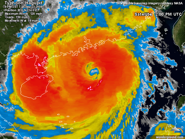
Hagupit made landfall in Guangdong's Dianbai county near the city of Maoming, packing winds of more than 200 kilometres per hour at its centre, the government's Xinhua news agency quoted meteorologists as saying.

One man died in Dianbai after he was blown down while trying to repair the roof of his house, the local Yangcheng Evening News said.

Gales uprooted many trees and tore down billboards while officials in Maoming said a fishing boat sank off Dianbai but no casualties were reported, Xinhua said.

All schools were closed in the worst-hit areas of Guangdong, and streets were deserted during the morning rush hour, it said.

Some reports said the typhoon was the worst to buffet Guangdong in a decade.

It weakened into a tropical storm later Wednesday, but heavy rain was forecast to continue on Thursday, bringing the risk of floods and landslides.

A team of 130 police officers battled for four hours early Wednesday to rescue about 50 people stranded when their village was flooded, the agency said.

Guangdong on Tuesday had called back to port more than 50,000 fishing vessels with nearly 200,000 crew.

Most flights in Guangdong's busy Shenzhen airport were cancelled Tuesday night and Wednesday morning, and all flights were cancelled at the main airport in Haikou, Hainan's capital.

Hagupit also grounded flights, closed schools and injured at least 58 people as it skirted Hong Kong early Wednesday.

Typhoon Hagupit, whose name means "lashing" in Filipino, caused eight deaths Monday when it raged across the northern Philippines before crossing the South China Sea. (dpa)
0 likes   

User avatar
Chacor
Category 5
Category 5
Posts: 10229
Joined: Mon Oct 02, 2006 10:43 pm
Location: Singapore

#115 Postby Chacor » Wed Sep 24, 2008 10:30 am

WTPQ21 RJTD 241200
RSMC TROPICAL CYCLONE ADVISORY
NAME TS 0814 HAGUPIT (0814) DOWNGRADED FROM STS
ANALYSIS
PSTN 241200UTC 21.9N 107.9E FAIR
MOVE W 10KT
PRES 985HPA
MXWD 045KT
GUST 065KT
30KT 180NM SOUTHEAST 70NM NORTHWEST
FORECAST
24HF 251200UTC 21.7N 104.5E 70NM 70% TROPICAL DEPRESSION =

Still deep convection.
Image
0 likes   

HenkL
S2K Supporter
S2K Supporter
Posts: 2401
Joined: Fri Sep 10, 2004 5:33 pm
Location: Groningen, The Netherlands
Contact:

#116 Postby HenkL » Wed Sep 24, 2008 10:41 am

GUANGZHOU, Sept. 24 (Xinhua) -- Three people died and two were missing as Typhoon Hagupit made landfall in south China's Guangdong Province early on Wednesday, local authorities said.

More than 4.94 million people in Maoming, Yangjiang, Zhuhai and Jiangmen cities were affected and 7,915 houses collapsed.

A Guangdong Provincial Flood Control and Drought Relief Headquarters official said 180,260 hectares of crops were affected and 38,980 ha were ruined.

He said 870 factories stopped production and 34 roads were cut off. In addition, 32 reservoirs and 287.8 km of dams were damaged. The direct economic loss was 5.45 billion yuan (800 million U.S. dollars), he said.

Also, 99 hydro stations recorded more than 100 millimeters of rain and 258 stations recorded more than 50 mm of rain on Wednesday, he said.

Er Jingping, general secretary of the State Flood Control and Drought Relief Headquarters and deputy head of the Water Resources Ministry, went to Guangdong to guide the rescue work on Wednesday morning.

The 14th strong typhoon of the year landed in Dianbai County in the city of Maoming at 6:45 a.m. with winds of more than 200 km per hour at its eye, the Guangdong Provincial Meteorological Bureau said.

source: Xinhua
0 likes   

CrazyC83
Professional-Met
Professional-Met
Posts: 33393
Joined: Tue Mar 07, 2006 11:57 pm
Location: Deep South, for the first time!

#117 Postby CrazyC83 » Wed Sep 24, 2008 10:47 am

Those numbers are sure to rise as well.
0 likes   

User avatar
Chacor
Category 5
Category 5
Posts: 10229
Joined: Mon Oct 02, 2006 10:43 pm
Location: Singapore

#118 Postby Chacor » Wed Sep 24, 2008 9:20 pm

WTPQ21 RJTD 250000
RSMC TROPICAL CYCLONE ADVISORY
NAME TD DOWNGRADED FROM TS 0814 HAGUPIT (0814)
ANALYSIS
PSTN 250000UTC 23N 106E
MOVE W SLOWLY
PRES 996HPA =
0 likes   


Return to “2008”

Who is online

Users browsing this forum: No registered users and 42 guests