ATL: Tropical Storm Kyle : Discussion

Moderator: S2k Moderators

Message
Author
User avatar
wxman57
Moderator-Pro Met
Moderator-Pro Met
Posts: 22482
Age: 66
Joined: Sat Jun 21, 2003 8:06 pm
Location: Houston, TX (southwest)

Re: ATL: Hurricane Kyle : Discussion

#1101 Postby wxman57 » Sun Sep 28, 2008 8:55 am

jconsor wrote:
Wxman,

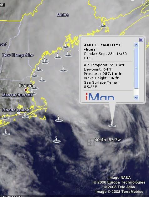
I agree that NHC is probably overestimating Kyle's winds. Satellite estimates do show a large area of 50 kt+ winds in the eastern quadrant. Buoy reports show that those satellite estimates are probably a bit too high also. However, with recon reporting a central pressure of 991 mb and high pressures nearby to the northeast, it is believable that there are about 60 kt winds in the northeast quadrant.

http://rammb.cira.colostate.edu/product ... 0_SWND.GIF


That satellite estimate looks pretty good - it matches surface obs in the area. I just don't see that Kyle is "strengthening" as per the NHC's discussion. More likely an area of 55-60kt winds in the NE quadrant and very little in the western semicircle.
0 likes   

Sanibel
Category 5
Category 5
Posts: 10348
Joined: Mon Aug 30, 2004 11:06 pm
Location: Offshore SW Florida

Re: ATL: Hurricane Kyle : Discussion

#1102 Postby Sanibel » Sun Sep 28, 2008 9:18 am

Landfall in Canada will tell you what kind of winds it has.


South-sheared naked eye.
0 likes   

User avatar
Just Joshing You
Category 2
Category 2
Posts: 512
Joined: Sat Nov 03, 2007 10:29 am
Location: Nova Scotia

#1103 Postby Just Joshing You » Sun Sep 28, 2008 9:43 am

I saw some graphic that showed 50 KT winds far, far from the surface center. I overlayed that image and it appears I'll be in sustained 50 kt winds if it doesn't weaken significantly.
Last edited by Just Joshing You on Sun Sep 28, 2008 9:44 am, edited 1 time in total.
0 likes   

CrazyC83
Professional-Met
Professional-Met
Posts: 33393
Joined: Tue Mar 07, 2006 11:57 pm
Location: Deep South, for the first time!

Re: ATL: Hurricane Kyle : Discussion

#1104 Postby CrazyC83 » Sun Sep 28, 2008 9:44 am

Sanibel wrote:Landfall in Canada will tell you what kind of winds it has.


South-sheared naked eye.


I remember the same happening with Juan (although he had a much better structure) and was estimated at about 70 kt at landfall before surface observations confirmed 85 kt winds.
0 likes   

User avatar
Just Joshing You
Category 2
Category 2
Posts: 512
Joined: Sat Nov 03, 2007 10:29 am
Location: Nova Scotia

#1105 Postby Just Joshing You » Sun Sep 28, 2008 9:45 am

Juan hit on a Sunday night at around the same time. lol go figure.
0 likes   

CrazyC83
Professional-Met
Professional-Met
Posts: 33393
Joined: Tue Mar 07, 2006 11:57 pm
Location: Deep South, for the first time!

Re:

#1106 Postby CrazyC83 » Sun Sep 28, 2008 9:45 am

Just Joshing You wrote:Juan hit on a Sunday night at around the same time. lol go figure.


Same day as well. The last time this calendar existed was in 2003.
0 likes   

User avatar
Just Joshing You
Category 2
Category 2
Posts: 512
Joined: Sat Nov 03, 2007 10:29 am
Location: Nova Scotia

#1107 Postby Just Joshing You » Sun Sep 28, 2008 9:56 am

That's a weird coincidence. I don't expect anything really bad from Kyle any longer, but there is the potential for damage.
0 likes   

User avatar
Just Joshing You
Category 2
Category 2
Posts: 512
Joined: Sat Nov 03, 2007 10:29 am
Location: Nova Scotia

#1108 Postby Just Joshing You » Sun Sep 28, 2008 10:14 am

OUCH Current track damn it.
0 likes   

User avatar
Just Joshing You
Category 2
Category 2
Posts: 512
Joined: Sat Nov 03, 2007 10:29 am
Location: Nova Scotia

Re: ATL: Hurricane Kyle : Discussion

#1109 Postby Just Joshing You » Sun Sep 28, 2008 10:19 am

Image

:(
0 likes   

CrazyC83
Professional-Met
Professional-Met
Posts: 33393
Joined: Tue Mar 07, 2006 11:57 pm
Location: Deep South, for the first time!

#1110 Postby CrazyC83 » Sun Sep 28, 2008 10:24 am

It has definitely shifted more right. I'm guessing landfall around Lockeport, NS.
0 likes   

User avatar
Just Joshing You
Category 2
Category 2
Posts: 512
Joined: Sat Nov 03, 2007 10:29 am
Location: Nova Scotia

#1111 Postby Just Joshing You » Sun Sep 28, 2008 10:37 am

This storm has the potential for 6 landfalls.. LOL
0 likes   

User avatar
tropicana
Category 5
Category 5
Posts: 8056
Joined: Sat Sep 27, 2003 6:48 pm
Location: Niagara Falls, Ontario, Canada
Contact:

Re: Re:

#1112 Postby tropicana » Sun Sep 28, 2008 10:39 am

CrazyC83 wrote:
Just Joshing You wrote:Juan hit on a Sunday night at around the same time. lol go figure.


Same day as well. The last time this calendar existed was in 2003.


Juan made landfall as a 100mph hurricane near to Halifax NS on the evening of Sunday, September 29, 2003.
It was described as the worst hurricane to hit the Halifax area.
Kyle will make landfall on the southern Nova Scotia shoreline it appears now, but its winds shouldnt be as strong as those
of Juan.
Still so interesting, almost 5 years to the exact day, date and time.

-justin-
0 likes   

jconsor
Professional-Met
Professional-Met
Posts: 532
Joined: Mon Jun 30, 2008 9:31 pm
Location: Jerusalem, Israel
Contact:

Re: Re:

#1113 Postby jconsor » Sun Sep 28, 2008 11:24 am

Georges Bank buoy at 41.1N 66.6W is getting pounded. Sustained winds of 60 mph, gusting to 80 mph, and pressure down to 990 mb.

http://www.ndbc.noaa.gov/station_page.php?station=44011
0 likes   

CrazyC83
Professional-Met
Professional-Met
Posts: 33393
Joined: Tue Mar 07, 2006 11:57 pm
Location: Deep South, for the first time!

Re: Re:

#1114 Postby CrazyC83 » Sun Sep 28, 2008 11:37 am

jconsor wrote:Georges Bank buoy at 41.1N 66.6W is getting pounded. Sustained winds of 60 mph, gusting to 80 mph, and pressure down to 990 mb.

http://www.ndbc.noaa.gov/station_page.php?station=44011


990/50 (kt) = 985mb central pressure?
0 likes   

CrazyC83
Professional-Met
Professional-Met
Posts: 33393
Joined: Tue Mar 07, 2006 11:57 pm
Location: Deep South, for the first time!

#1115 Postby CrazyC83 » Sun Sep 28, 2008 12:00 pm

I also believe buoy estimates are 8-minute sustained winds.
0 likes   

CrazyC83
Professional-Met
Professional-Met
Posts: 33393
Joined: Tue Mar 07, 2006 11:57 pm
Location: Deep South, for the first time!

#1116 Postby CrazyC83 » Sun Sep 28, 2008 12:14 pm

That buoy is now reporting a 987mb pressure.
0 likes   

Praxus
Category 1
Category 1
Posts: 473
Joined: Tue Aug 31, 2004 3:19 pm

Re:

#1117 Postby Praxus » Sun Sep 28, 2008 12:33 pm

CrazyC83 wrote:That buoy is now reporting a 987mb pressure.

:eek:

Had to find a converter to understand the 29.15 reading...dunno why they don't use millibars like the NHC.
0 likes   

User avatar
wxman57
Moderator-Pro Met
Moderator-Pro Met
Posts: 22482
Age: 66
Joined: Sat Jun 21, 2003 8:06 pm
Location: Houston, TX (southwest)

Re: ATL: Hurricane Kyle : Discussion

#1118 Postby wxman57 » Sun Sep 28, 2008 12:42 pm

Well, the buoy confirms Kyle is a tropical storm. But absolutely no evidence of hurricane force winds at the surface. Winds 100 miles west of the center are 10-15 kts. Here's a 17Z sfc plot, not much of a wind field, and certainly not a hurricane. That would be a cold front extending from the eastern side of Kyle, by the way.

Image
0 likes   

User avatar
Dave
Retired Staff
Retired Staff
Posts: 13442
Age: 73
Joined: Tue Aug 01, 2006 3:57 pm
Location: Milan Indiana
Contact:

#1119 Postby Dave » Sun Sep 28, 2008 12:43 pm

Image

As of 1650 UTC from 44011
0 likes   

User avatar
Just Joshing You
Category 2
Category 2
Posts: 512
Joined: Sat Nov 03, 2007 10:29 am
Location: Nova Scotia

#1120 Postby Just Joshing You » Sun Sep 28, 2008 12:44 pm

Light breeze from where I am located.
0 likes   


Return to “2008”

Who is online

Users browsing this forum: No registered users and 118 guests