BEGIN
NHC
invest_al942008.invest
FSTDA
R
U
040
010
0000
200809241151
NONE
NOTIFY=ATRP
ftp://ftp.tpc.ncep.noaa.gov/atcf/tcweb/
System off Carolinas.Discuss all about it.
ATL INVEST 94L: Discussion
Moderator: S2k Moderators
-
cycloneye

- Admin

- Posts: 139020
- Age: 67
- Joined: Thu Oct 10, 2002 10:54 am
- Location: San Juan, Puerto Rico
ATL INVEST 94L: Discussion
0 likes
-
cycloneye
- Admin
- Posts: 139020
- Age: 67
- Joined: Thu Oct 10, 2002 10:54 am
- Location: San Juan, Puerto Rico
Re: ATL: INVEST 94L: Discussion
12:00 UTC BEST TRACK:
AL, 94, 2008092412, , BEST, 0, 320N, 750W, 55, 0, DB, 0, , 0, 0, 0, 0,
55kts
AL, 94, 2008092412, , BEST, 0, 320N, 750W, 55, 0, DB, 0, , 0, 0, 0, 0,
55kts
0 likes
-
HURAKAN

- Professional-Met

- Posts: 46086
- Age: 37
- Joined: Thu May 20, 2004 4:34 pm
- Location: Key West, FL
- Contact:
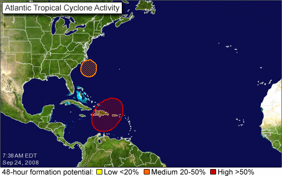
TROPICAL WEATHER OUTLOOK
NWS TPC/NATIONAL HURRICANE CENTER MIAMI FL
800 AM EDT WED SEP 24 2008
FOR THE NORTH ATLANTIC...CARIBBEAN SEA AND THE GULF OF MEXICO...
SHOWERS AND THUNDERSTORMS ASSOCIATED WITH THE BROAD AREA OF LOW
PRESSURE OVER HISPANIOLA HAVE DECREASED SOMEWHAT THIS MORNING.
THIS SYSTEM DOES NOT HAVE A WELL-DEFINED SURFACE CIRCULATION...BUT
ATMOSPHERIC CONDITIONS APPEAR TO BE FAVORABLE FOR TROPICAL CYCLONE
FORMATION AS IT MOVES GENERALLY NORTHWARD...AND AWAY FROM
HISPANIOLA...TODAY AND TONIGHT. THERE IS STILL THE POTENTIAL FOR
HEAVY RAINFALL AND LIFE-THREATENING FLASH FLOODS AND MUD SLIDES
OVER HISPANIOLA DURING THE NEXT DAY OR SO.
WILMINGTON NORTH CAROLINA. ALTHOUGH THIS LOW IS CURRENTLY
ASSOCIATED WITH A FRONTAL ZONE...IT HAS THE POTENTIAL TO DEVELOP
INTO A TROPICAL OR SUBTROPICAL CYCLONE AS IT MOVES SLOWLY WESTWARD
OVER THE NEXT DAY OR TWO. HIGH SURF AND DANGEROUS RIP CURRENTS
ASSOCIATED WITH THIS SYSTEM WILL AFFECT PORTIONS OF THE U.S. EAST
COAST FOR THE NEXT SEVERAL DAYS. CONSULT STATEMENTS FROM LOCAL
NATIONAL WEATHER SERVICE FORECAST OFFICES FOR ADDITIONAL
INFORMATION.
ELSEWHERE...TROPICAL CYCLONE FORMATION IS NOT EXPECTED DURING THE
NEXT 48 HOURS.
$$
FORECASTER PASCH/BERG
0 likes
-
DESTRUCTION5

- Category 5

- Posts: 4391
- Age: 42
- Joined: Wed Sep 03, 2003 11:25 am
- Location: Stuart, FL
-
HURAKAN
- Professional-Met
- Posts: 46086
- Age: 37
- Joined: Thu May 20, 2004 4:34 pm
- Location: Key West, FL
- Contact:
Re:
DESTRUCTION5 wrote:55Kts? STS Kyle at 11:00AM?

Don't know if at 11 AM, but for a system that formed yesterday the area of convection looks colocated with the LLC and certainly it's subtropical.
0 likes
-
invest man
- Tropical Storm

- Posts: 204
- Joined: Sun Aug 17, 2008 8:12 pm
Re: ATL: INVEST 94L: Discussion
Does anyone think there could be watches or warnings issued by NHC for part of the Carolina's by 2PM? IM
0 likes
-
hurricanedude

- Military Member

- Posts: 1856
- Joined: Tue Oct 08, 2002 9:54 am
- Location: Virginia Beach, Virginia
- Contact:
Re: ATL: INVEST 94L: Discussion
well there are already storm warnings for the NC and VA coast...so a TS warning or a storm warning...pretty much the same impact
0 likes
-
AJC3

- Admin
- Posts: 3868
- Age: 60
- Joined: Tue Aug 31, 2004 7:04 pm
- Location: West Melbourne, Florida
- Contact:
Re:
DESTRUCTION5 wrote:55Kts? STS Kyle at 11:00AM?
55kt gale center.
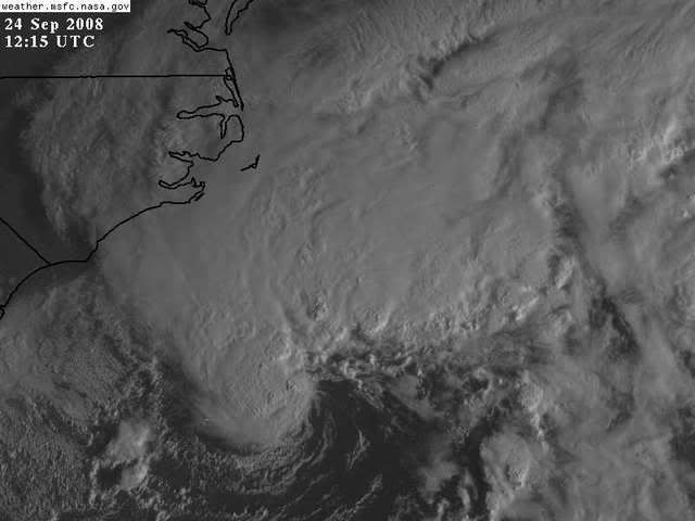
I like to start off by looking at the bigger (synoptic) picture. For starters, this cyclone is being generated by a cold core mid to upper level cutoff low. The central convection is likely a function of instability via cold air aloft, and the large swath of convection to the north resembles more of a baroclinic leaf. You can see plenty of stable air stratocu on its W-SW flank, courtesy of the fact that a large surface high to it's north is pushing cool air down most of the eastern seaboard. And I suspect the wind field is pretty broad as well.
Check the surface observations out here...
http://www.rap.ucar.edu/weather/surface ... duration=0
The main question for XTC vs STC is when does is shed it's frontal boundary. One could argue that the discontinuity in temperature (as well as dew point/thetae) across it's S and SW flank has already become broad enough that it may not qualify as a true front anymore. I strongly suspect that there is some sort of a coastal front along the northeast and mid-Atlantic seaboard that the cyclone may still be tangled up with.
[soapbox] This is where someone on the web needs to step up and put together a REALLY good and TIMELY hourly surface plot that includes all surface and marine (buoy, c-man and ship) observations. UCAR has a nice surface plot interface, but it lacks marine observations. PSU has a nice marine plot, but it doesn't include land observations with it. I've seen other plots, but they're not to my liking...and I can't exactly bring AWIPS home from work with me.
All that having been said, you have a strong gale center over warm water, in close proximity to the gulf stream that looks like it doesn't have very far at all to go to become a subtropical cyclone, and then perhaps transitioning into a full-blown TC if it can stay out over warm water long enough.
0 likes


-
Ed Mahmoud
Re: ATL: INVEST 94L: Discussion
JB was on the case a week ago...
Ed Mahmoud wrote:12Z GFS Loop
Per the JB video, old rule from the days before computer models that his father subscribed to - mid August to mid October, pressure reaches/exceeds 1025 mb at Cape Hatteras, look out to the South.
I guess because pressure that high over Hatteras implies strong East winds over the SE US and Bahamas, and the Florida landmass causes slowing/convergence.
GFS shows big time Northeast US high pressure, and then falling pressure, kind of in the shape of an inverted trough in the next week.
GFS also shows Cape Verde season trying to refire, although it seems to be getting less likely something can get all the way across to North America/the islands in late September.
0 likes
-
Matt-hurricanewatcher

- Category 5
- Posts: 11649
- Age: 38
- Joined: Fri Nov 26, 2004 11:09 pm
- Location: Portland,OR
- Contact:
Re: ATL: INVEST 94L: Discussion
Looking good...Watch as the convection increases in the center and decreases within the frontal bands...This could become Kyle by 5pm or 11.
Last edited by Matt-hurricanewatcher on Wed Sep 24, 2008 7:58 am, edited 1 time in total.
0 likes
-
wxman57

- Moderator-Pro Met

- Posts: 22480
- Age: 66
- Joined: Sat Jun 21, 2003 8:06 pm
- Location: Houston, TX (southwest)
Re: Re:
AJC3 wrote:
[soapbox] This is where someone on the web needs to step up and put together a REALLY good and TIMELY hourly surface plot that includes all surface and marine (buoy, c-man and ship) observations. UCAR has a nice surface plot interface, but it lacks marine observations. PSU has a nice marine plot, but it doesn't include land observations with it. I've seen other plots, but they're not to my liking...and I can't exactly bring AWIPS home from work with me.[/soapbox]
Here's a surface plot. Won't be able to update it regularly, though.

0 likes
-
weatherwoman

- Category 1

- Posts: 364
- Joined: Sun Sep 05, 2004 9:09 pm
- Location: Newport North Carolina
- Contact:
Re: ATL: INVEST 94L: Discussion
Wouldnt it be cool if this became Kyle before the 93L, We have been under strong winds for two days here on the coast of NC looks like we have a couple more days of this, when the rain sets in tonight it will be just like Hannah all over again, except for this time maybe we will actually get some rain,
0 likes

Re: ATL: INVEST 94L: Discussion
High Wind Warning already in effect....essentially the same wind threshold as a tropical storm warning...not 'less' of a warning in any way. Also Coastal Flood Warnings and Storm Warnings offshore...
NATIONAL WEATHER SERVICE NEWPORT/MOREHEAD CITY NC
433 AM EDT WED SEP 24 2008
MAINLAND DARE-MAINLAND HYDE-CARTERET-OUTER BANKS DARE-
OUTER BANKS HYDE-
INCLUDING THE CITIES OF...MOREHEAD CITY...BEAUFORT...
EMERALD ISLE...NEWPORT...KILL DEVIL HILLS...KITTY HAWK...
NAGS HEAD...SOUTHERN SHORES
433 AM EDT WED SEP 24 2008
...HIGH WIND WARNING REMAINS IN EFFECT UNTIL 5 AM EDT THURSDAY...
STRONG HIGH PRESSURE OVER NEW ENGLAND COUPLED WITH DEVELOPING LOW
PRESSURE OFF THE COAST OF THE CAROLINAS WILL PRODUCE STRONG NORTH
TO NORTHEAST WINDS OF 35 TO 45 MPH WITH GUSTS AS HIGH AS 60 MPH
FROM DOWN EAST CARTERET COUNTY ACROSS TO THE OUTER BANKS. THE
STRONGEST WINDS WILL OCCUR THIS AFTERNOON AND EVENING. RESIDENTS
IN THE WARNING AREA SHOULD TAKE ACTION TODAY TO PREPARE FOR THE
VERY WINDY CONDITIONS.
A HIGH WIND WARNING MEANS A HAZARDOUS HIGH WIND EVENT IS EXPECTED
OR OCCURRING. SUSTAINED WIND SPEEDS OF AT LEAST 40 MPH OR GUSTS
OF 58 MPH OR MORE CAN LEAD TO PROPERTY DAMAGE.
invest man wrote:Does anyone think there could be watches or warnings issued by NHC for part of the Carolina's by 2PM? IM
0 likes
-
jconsor
- Professional-Met
- Posts: 533
- Joined: Mon Jun 30, 2008 9:31 pm
- Location: Jerusalem, Israel
- Contact:
Re: ATL: INVEST 94L: Discussion
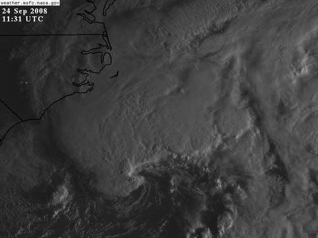
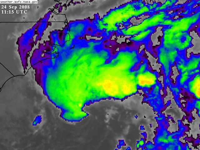
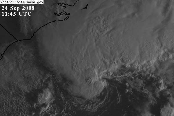
SSD thinks this is subtropical:
24/1145 UTC 32.0N 74.9W ST2.5 94L -- Atlantic Ocean
24/1145 UTC 32.0N 74.9W ST2.5 94L -- Atlantic Ocean
0 likes
-
Weatherfreak000
Re: ATL: INVEST 94L: Discussion
Dvorak supports STS intensity...LLC clearly present...
This should be upgraded today. What an amazingly fast development. Convection appears to be wrapping around nicely so I wouldn't expect to see this Subtropical for very long.
Likely it's Subtropical due to pretty high wind sheap from the north...which is somewhat displacing convection from the center....it seems if Wind Shear maps are correct those winds should relax to about the level at least the storm should be able to wrap the convection around.
0 likes
-
weatherwoman
- Category 1
- Posts: 364
- Joined: Sun Sep 05, 2004 9:09 pm
- Location: Newport North Carolina
- Contact:
Re: ATL: INVEST 94L: Discussion
Weatherfreak000 wrote:Dvorak supports STS intensity...LLC clearly present...
This should be upgraded today. What an amazingly fast development. Convection appears to be wrapping around nicely so I wouldn't expect to see this Subtropical for very long.
Likely it's Subtropical due to pretty high wind sheap from the north...which is somewhat displacing convection from the center....it seems if Wind Shear maps are correct those winds should relax to about the level at least the storm should be able to wrap the convection around.
so are you saying this could be tropical? or stay subtropical
0 likes
Who is online
Users browsing this forum: No registered users and 33 guests