TROPICAL WEATHER OUTLOOK
NWS TPC/NATIONAL HURRICANE CENTER MIAMI FL
200 AM EDT MON SEP 29 2008
FOR THE NORTH ATLANTIC...CARIBBEAN SEA AND THE GULF OF MEXICO...
THE NATIONAL HURRICANE CENTER HAS ISSUED THE FINAL ADVISORY ON
TROPICAL STORM KYLE. THIS SYSTEM HAS TRANSITIONED INTO A
NON-TROPICAL LOW PRESSURE SYSTEM LOCATED OVER THE BAY OF FUNDY IN
THE CANADIAN MARITIMES REGION.
THUNDERSTORM ACTIVITY HAS INCREASED AND BECOME A MORE CONCENTRATED
NEAR THE CENTER OF A LARGE NON-TROPICAL LOW PRESSURE SYSTEM LOCATED
OVER THE CENTRAL NORTH ATLANTIC OCEAN ABOUT 840 MILES WEST OF THE
WESTERNMOST AZORES ISLANDS. THIS SYSTEM IS GRADUALLY ACQUIRING
TROPICAL CHARACTERISTICS AND IT HAS THE POTENTIAL TO BECOME A
SUBTROPICAL OR TROPICAL STORM LATER TODAY AS IT MOVES GENERALLY
WEST-NORTHWESTWARD AT AROUND 10 MPH. ADDITIONAL INFORMATION ON THIS
GALE AREA CAN BE FOUND IN HIGH SEAS FORECASTS ISSUED BY THE NOAA
OCEAN PREDICTION CENTER UNDER AWIPS HEADER NFDHSFAT1 AND UNDER WMO
HEADER FZNT01 KWBC.
ELSEWHERE...TROPICAL CYCLONE FORMATION IS NOT EXPECTED DURING THE
NEXT 48 HOURS.
$$
FORECASTER STEWART
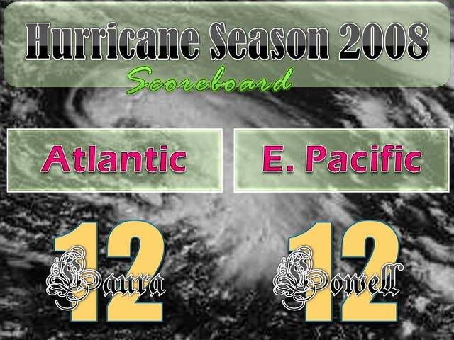
ATL LAURA: Tropical Storm - Discussion
Moderator: S2k Moderators
-
Brent
- S2K Supporter

- Posts: 37100
- Age: 35
- Joined: Sun May 16, 2004 10:30 pm
- Location: Tulsa Oklahoma
- Contact:
Re: ATL: INVEST 95L : Discussion
0 likes
-
Matt-hurricanewatcher

- Category 5

- Posts: 11649
- Age: 38
- Joined: Fri Nov 26, 2004 11:09 pm
- Location: Portland,OR
- Contact:
Re: ATL: INVEST 95L : Discussion
Convection starting to wrap into the core of this, it is also forming a tighter core. I think it is on the border of becoming a subtropical storm.
0 likes

WTNT22 KNHC 290831
TCMAT2
SUBTROPICAL STORM LAURA FORECAST/ADVISORY NUMBER 1
NWS TPC/NATIONAL HURRICANE CENTER MIAMI FL AL122008
0900 UTC MON SEP 29 2008
SUBTROPICAL STORM CENTER LOCATED NEAR 37.2N 47.3W AT 29/0900Z
POSITION ACCURATE WITHIN 20 NM
PRESENT MOVEMENT TOWARD THE WEST-NORTHWEST OR 285 DEGREES AT 7 KT
ESTIMATED MINIMUM CENTRAL PRESSURE 993 MB
MAX SUSTAINED WINDS 50 KT WITH GUSTS TO 60 KT.
50 KT....... 80NE 80SE 100SW 120NW.
34 KT.......240NE 200SE 210SW 270NW.
12 FT SEAS..480NE 400SE 480SW 300NW.
WINDS AND SEAS VARY GREATLY IN EACH QUADRANT. RADII IN NAUTICAL
MILES ARE THE LARGEST RADII EXPECTED ANYWHERE IN THAT QUADRANT.
REPEAT...CENTER LOCATED NEAR 37.2N 47.3W AT 29/0900Z
AT 29/0600Z CENTER WAS LOCATED NEAR 37.0N 47.0W
FORECAST VALID 29/1800Z 38.0N 48.3W
MAX WIND 55 KT...GUSTS 65 KT.
50 KT... 80NE 80SE 90SW 100NW.
34 KT...240NE 200SE 210SW 270NW.
FORECAST VALID 30/0600Z 39.8N 48.9W
MAX WIND 60 KT...GUSTS 75 KT.
50 KT... 90NE 90SE 80SW 90NW.
34 KT...240NE 220SE 200SW 235NW.
FORECAST VALID 30/1800Z 41.7N 48.8W...BECOMING EXTRATROPICAL
MAX WIND 60 KT...GUSTS 75 KT.
50 KT...100NE 100SE 70SW 80NW.
34 KT...240NE 240SE 180SW 200NW.
FORECAST VALID 01/0600Z 44.0N 48.0W...EXTRATROPICAL
MAX WIND 55 KT...GUSTS 65 KT.
50 KT...100NE 100SE 70SW 80NW.
34 KT...240NE 240SE 170SW 190NW.
FORECAST VALID 02/0600Z 51.5N 44.0W...EXTRATROPICAL
MAX WIND 50 KT...GUSTS 60 KT.
50 KT...100NE 100SE 70SW 80NW.
34 KT...240NE 240SE 150SW 160NW.
EXTENDED OUTLOOK. NOTE...ERRORS FOR TRACK HAVE AVERAGED NEAR 225 NM
ON DAY 4 AND 300 NM ON DAY 5...AND FOR INTENSITY NEAR 20 KT EACH DAY
OUTLOOK VALID 03/0600Z 58.0N 34.5W...EXTRATROPICAL
MAX WIND 45 KT...GUSTS 55 KT.
OUTLOOK VALID 04/0600Z 57.0N 21.5W...EXTRATROPICAL
MAX WIND 40 KT...GUSTS 50 KT.
REQUEST FOR 3 HOURLY SHIP REPORTS WITHIN 300 MILES OF 37.2N 47.3W
NEXT ADVISORY AT 29/1500Z
$$
FORECASTER STEWART
0 likes
-
Matt-hurricanewatcher
- Category 5
- Posts: 11649
- Age: 38
- Joined: Fri Nov 26, 2004 11:09 pm
- Location: Portland,OR
- Contact:
Re: ATL: INVEST 95L : Discussion
I like stewart a lot because he is truthful and to the point. I hope he becomes the next director very soon. WAHOO!!!
0 likes
-
wxman57

- Moderator-Pro Met

- Posts: 22482
- Age: 66
- Joined: Sat Jun 21, 2003 8:06 pm
- Location: Houston, TX (southwest)
Re: ATL: INVEST 95L : Discussion
They sure were quick to name this "non-tropical storm" when they wouldn't name 94L even with recon confirming a warm core. Could have at least waited for a decent hour to name it so I wouldn't have to get a phone call at 3:30am.
0 likes
-
Lowpressure

- S2K Supporter
- Posts: 2032
- Age: 57
- Joined: Sun Sep 14, 2003 9:17 am
- Location: Charlotte, North Carolina
Re: ATL: INVEST 95L : Discussion
wxman57 wrote:They sure were quick to name this "non-tropical storm" when they wouldn't name 94L even with recon confirming a warm core. Could have at least waited for a decent hour to name it so I wouldn't have to get a phone call at 3:30am.
I hear ya, and good point. Even when the system was over the Charlotte area, local NWS referred to it as warm core in bold print.
0 likes
-
Matt-hurricanewatcher
- Category 5
- Posts: 11649
- Age: 38
- Joined: Fri Nov 26, 2004 11:09 pm
- Location: Portland,OR
- Contact:
Re: ATL: INVEST 95L : Discussion
Convection is wraping all the way around the center, this should be fully tropical by 11am or maybe 5pm. I think they named it at the right now...I agree with you on 94L wxman57.
0 likes


-
cycloneye

- Admin

- Posts: 139082
- Age: 67
- Joined: Thu Oct 10, 2002 10:54 am
- Location: San Juan, Puerto Rico
Re: ATL: Subropical Storm Laura: Discussion
29/1145 UTC 37.1N 47.4W T3.0/3.0 LAURA -- Atlantic Ocean
http://www.ssd.noaa.gov/PS/TROP/positions.html
No ST beside the T Numbers.
0 likes
I'm sure this will be mentioned more than once, so, without further ado...
http://www.youtube.com/watch?v=nYEWeBarLww
http://www.youtube.com/watch?v=nYEWeBarLww
Last edited by Frank2 on Mon Sep 29, 2008 7:57 am, edited 1 time in total.
0 likes
-
HURAKAN

- Professional-Met

- Posts: 46086
- Age: 37
- Joined: Thu May 20, 2004 4:34 pm
- Location: Key West, FL
- Contact:
Re:
Frank2 wrote:I'm sure this will be mentioned more than once:
http://www.youtube.com/watch?v=nYEWeBarLww
Being Hispanic the song that comes to mind is "Lady Laura" from Roberto Carlos. Luis probably knows this one because it's not of my generation but I have heard it many times and I like it.
http://www.youtube.com/watch?v=tkYaFy_4X6w
0 likes
...I never heard of that one, but, back in high school I did watch General Hospital from time to time (!), and, knew who Laura was when the Christopher Cross song came out in the early 1980's...
I think I was sweet on the actress who played the part - just a bit...
LOL
P.S. Just to stay within the topic - I'm sure this actress (Genie Francis) will probably smile when she hears the news that her namesake is now a tropical weather system...
P.P.S. Ironically, she was brought back in the Laura role just last month after an absence of a number of years...
http://www.usatoday.com/life/television ... htm?csp=34
P.P.P.S. Back to the topic at hand - I'll guess that JB (AW) will have some "Why this time?" comments directed at the NHC for naming this but not last week's system - he's somethin' else, that's for sure...
0 likes
-
Derek Ortt
-
cycloneye
- Admin
- Posts: 139082
- Age: 67
- Joined: Thu Oct 10, 2002 10:54 am
- Location: San Juan, Puerto Rico
Re: ATL: Subropical Storm Laura: Discussion
Code: Select all
                     UW - CIMSS
              ADVANCED DVORAK TECHNIQUE
                  ADT-Version 7.2.3
         Tropical Cyclone Intensity Algorithm

             ----- Current Analysis -----
     Date :  29 SEP 2008    Time :   121500 UTC
      Lat :   37:27:15 N     Lon :   47:38:37 W


                CI# /Pressure/ Vmax
                3.2 / 997.6mb/ 49.0kt


             Final T#  Adj T#  Raw T#
             (3hr avg)
                3.2     3.2     3.2

     Latitude bias adjustment to MSLP :  +0.0mb

 Center Temp :  +8.8C    Cloud Region Temp : -22.7C

 Scene Type : USER DEFINED INITIAL CLASSIFICATION
              Maximum CURVED BAND with 0.60 ARC in MD GRAY
               at Lat:  37:27:00 N  Lon:  47:14:24 W

 Positioning Method : FORECAST INTERPOLATION

 Ocean Basin : ATLANTIC
 Dvorak CI > MSLP Conversion Used : ATLANTIC

 Tno/CI Rules : Constraint Limits : NO LIMIT
                   Weakening Flag : OFF
           Rapid Dissipation Flag : OFF
http://cimss.ssec.wisc.edu/tropic2/real ... dt12L.html
0 likes
-
tropicana

- Category 5
- Posts: 8056
- Joined: Sat Sep 27, 2003 6:48 pm
- Location: Niagara Falls, Ontario, Canada
- Contact:
Re: ATL: Subropical Storm Laura: Discussion
A GALE WARNING will be issued for the South-Eastern Grand Banks off of Newfoundland with the approach of Laura, storm force winds are possible over this area also for Tuesday night into Wednesday as the storm passes near or through this general area.
On another note, this is another Laura song, thanks to my mom for telling me about it hahaha:-
http://www.youtube.com/watch?v=bjvah1TDZxE
On another note, this is another Laura song, thanks to my mom for telling me about it hahaha:-
http://www.youtube.com/watch?v=bjvah1TDZxE
0 likes
-
DESTRUCTION5

- Category 5
- Posts: 4391
- Age: 42
- Joined: Wed Sep 03, 2003 11:25 am
- Location: Stuart, FL
Re:
Derek Ortt wrote:Frank
in 2005, we had a little storm by the name of Wilma after a subtrop and hurricane Vince in the NE Atlantic
I do recall that name...
0 likes
Who is online
Users browsing this forum: No registered users and 110 guests