ATL: Marco : Tropical Depression - Discussion
Moderator: S2k Moderators
-
Category 5

- Category 5

- Posts: 10074
- Age: 34
- Joined: Sun Feb 11, 2007 10:00 pm
- Location: New Brunswick, NJ
- Contact:
Re: ATL: Marco : Tropical Storm - Discussion
Another question, will they considered this as tied with Monica for smallest TC on record?
0 likes
-
HURAKAN

- Professional-Met

- Posts: 46086
- Age: 37
- Joined: Thu May 20, 2004 4:34 pm
- Location: Key West, FL
- Contact:
Re: ATL: Marco : Tropical Storm - Discussion
Category 5 wrote:Another question, will they considered this as tied with Monica for smallest TC on record?
Monica? Isn't Tracy the smallest?
0 likes
-
HurricaneRobert
- Category 3

- Posts: 812
- Joined: Fri May 18, 2007 9:31 pm
Re: ATL: Marco : Tropical Storm - Discussion
Not the first midget Marco.

Too bad they didn't have two earlier East Pacific storms. Then this would've been Marco and the other side of Mexico would've had Polo.
Too bad they didn't have two earlier East Pacific storms. Then this would've been Marco and the other side of Mexico would've had Polo.
0 likes

Re:
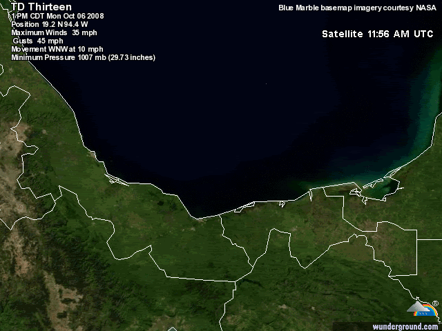
HURAKAN wrote:06/1745 UTC 19.0N 94.4W T2.0/2.0 13L
This is why RECON is so important. Big difference between 2.0 and 3.5.
I would assume it's because dvorak technique doesn't work on tiny systems like Marco very well.
0 likes
-
HURAKAN
- Professional-Met
- Posts: 46086
- Age: 37
- Joined: Thu May 20, 2004 4:34 pm
- Location: Key West, FL
- Contact:
Re: Re:
superfly wrote:HURAKAN wrote:06/1745 UTC 19.0N 94.4W T2.0/2.0 13L
This is why RECON is so important. Big difference between 2.0 and 3.5.
I would assume it's because dvorak technique doesn't work on tiny systems like Marco very well.
Code: Select all
=====  ADT-Version 7.2.3 =====
                  --------Intensity------- -Tno Values-- ---Tno/CI Rules---  -Temperature-
           Time        Final/MSLPLat/Vmax   Fnl Adj Ini   Cnstrnt Wkng Rpd    Cntr   Mean   Scene  EstRMW   Storm Location  Fix
   Date    (UTC)   CI  MSLP /BiasAdj/(kts)  3hr Raw Raw    Limit  Flag Wkng  Region  Cloud  Type    (km)     Lat     Lon    Mthd   Comments
2008OCT06 141500  2.0 1009.0/  +0.0 / 30.0  2.0 2.0 2.0  NO LIMIT  OFF  OFF  -51.06 -26.47  UNIFRM   N/A    18.97   94.00   FCST
2008OCT06 144500  2.1 1008.2/  +0.0 / 31.0  2.1 2.2 2.7  0.2T/hour OFF  OFF  -65.36 -28.72  UNIFRM   N/A    18.99   94.07   FCST
2008OCT06 151500  2.1 1008.2/  +0.0 / 31.0  2.1 2.2 2.7  0.2T/hour OFF  OFF  -60.06 -31.29  UNIFRM   N/A    19.01   94.13   FCST
2008OCT06 154500  2.2 1007.4/  +0.0 / 32.0  2.2 2.4 2.8  0.2T/hour OFF  OFF  -58.26 -33.29  UNIFRM   N/A    19.03   94.20   FCST
2008OCT06 161500  2.2 1007.4/  +0.0 / 32.0  2.2 2.4 3.4  0.2T/hour OFF  OFF  -52.96 -34.88  CRVBND   N/A    19.05   94.27   FCST
2008OCT06 164900  2.3 1006.6/  +0.0 / 33.0  2.3 2.6 3.4  0.2T/hour OFF  OFF  -44.46 -36.50  CRVBND   N/A    19.07   94.34   FCST
2008OCT06 171500  2.3 1006.6/  +0.0 / 33.0  2.3 2.6 3.4  0.2T/hour OFF  OFF  -48.96 -35.40  CRVBND   N/A    19.09   94.40   FCST
2008OCT06 174500  2.4 1005.8/  +0.0 / 34.0  2.4 2.8 3.2  0.2T/hour OFF  OFF  -50.46 -36.47  CRVBND   N/A    19.11   94.47   FCST
2008OCT06 181500  2.5 1005.0/  +0.0 / 35.0  2.5 2.8 3.2  0.2T/hour OFF  OFF  -47.26 -35.24  CRVBND   N/A    19.13   94.53   FCST
2008OCT06 184500  2.6 1004.0/  +0.0 / 37.0  2.6 3.0 3.0  NO LIMIT  OFF  OFF  -43.16 -34.35  CRVBND   N/A    19.15   94.60   FCST
2008OCT06 191500  2.6 1004.0/  +0.0 / 37.0  2.6 2.7 2.7  NO LIMIT  OFF  OFF  -34.96 -32.45  CRVBND   N/A    19.17   94.67   FCST
2008OCT06 194500  2.7 1003.0/  +0.0 / 39.0  2.7 2.8 2.5  0.2T/hour OFF  OFF  -28.26 -31.18  CRVBND   N/A    19.19   94.73   FCST
2008OCT06 201500  2.8 1002.0/  +0.0 / 41.0  2.8 2.9 3.5  0.2T/hour OFF  OFF  -62.26 -30.13  CRVBND   N/A    19.47   94.65   FCST
2008OCT06 204500  2.8 1002.0/  +0.0 / 41.0  2.8 2.8 3.4  0.7T/6hr  OFF  OFF  -61.16 -28.85  CRVBND   N/A    19.49   94.68   FCST
2008OCT06 211500  2.8 1002.0/  +0.0 / 41.0  2.8 2.8 3.5  0.7T/6hr  OFF  OFF  -58.96 -27.95  CRVBND   N/A    19.51   94.72   FCST
2008OCT06 214500  2.8 1002.0/  +0.0 / 41.0  2.8 2.9 3.2  0.7T/6hr  OFF  OFF  -58.26 -26.88  CRVBND   N/A    19.53   94.76   FCST
Utilizing history file /home/misc/adt/scripts/history/13L.ODT
Successfully completed listing
RAW has been doing excellent.
0 likes


-
Epsilon_Fan

- Category 1

- Posts: 353
- Joined: Fri Jan 13, 2006 1:03 pm
- Location: Charleston, SC
Re: ATL: Marco : Tropical Storm - Discussion
awwwwwwwwww
It's funny that you are a letter swap away from TS MACRO, when it's this tiny it should probably be TS MICRO. haha
maybe this will crank into a itty bitty hurricane
It's funny that you are a letter swap away from TS MACRO, when it's this tiny it should probably be TS MICRO. haha
maybe this will crank into a itty bitty hurricane
0 likes

Re: ATL: Marco : Tropical Storm - Discussion
Small systems like this can spin up very quickly.....a 30-mile swath of even sustained 55 or 65 mph winds can do a significant amount of damage to trees, powelines, etc. Not to mention the possibility he could even become a Cat 1 before landfall (NHC puts that at 26% probability during next 24 hours...even a 2% probability of a Cat 2....not too shabby for something that wasn't even an invest earlier today... as of 5pm advisory-see Wind Probability section of advisory).
Marco may not effect a large area, but he could pack quick a punch where he does.
Interesting discussion from Dr. Jeff Masters:
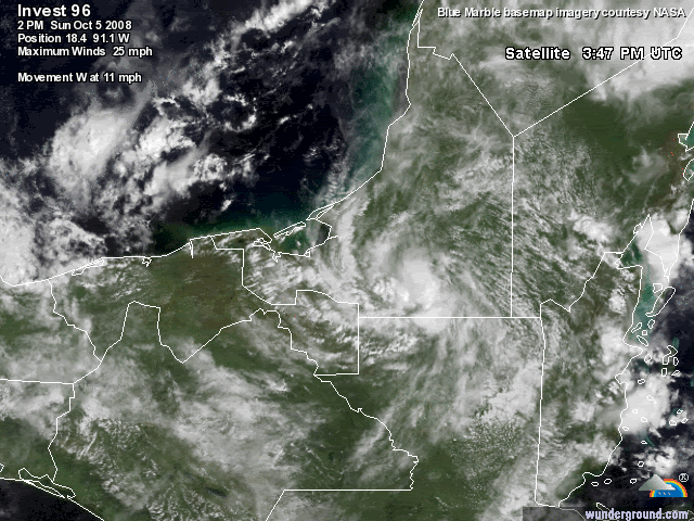
Surprising Tropical Storm Marco has burst onto the scene in the extreme southern portion of the Gulf of Mexico. In just five hours, the tiny storm has spun up to near hurricane strength, a remarkable rapid intensification feat. Visible satellite loops show a tiny storm with a concentrated area of heavy thunderstorms, moving west-northwest at about 10 mph. In another example of why we need the Hurricane Hunters, an Air Force airplane that scrambled to fly Marco with little advance notice found top winds of 65 mph and a 998 mb pressure at 4:19 pm EDT. Satellite estimates using the traditional Dvorak Technique were still classifying Marco as a tropical depression with 35 mph winds this afternoon.
http://www.wunderground.com/blog/JeffMasters/comment.html?entrynum=1115&tstamp=200810
Marco may not effect a large area, but he could pack quick a punch where he does.
Interesting discussion from Dr. Jeff Masters:
Surprising Tropical Storm Marco has burst onto the scene in the extreme southern portion of the Gulf of Mexico. In just five hours, the tiny storm has spun up to near hurricane strength, a remarkable rapid intensification feat. Visible satellite loops show a tiny storm with a concentrated area of heavy thunderstorms, moving west-northwest at about 10 mph. In another example of why we need the Hurricane Hunters, an Air Force airplane that scrambled to fly Marco with little advance notice found top winds of 65 mph and a 998 mb pressure at 4:19 pm EDT. Satellite estimates using the traditional Dvorak Technique were still classifying Marco as a tropical depression with 35 mph winds this afternoon.
http://www.wunderground.com/blog/JeffMasters/comment.html?entrynum=1115&tstamp=200810
0 likes


-
HURAKAN
- Professional-Met
- Posts: 46086
- Age: 37
- Joined: Thu May 20, 2004 4:34 pm
- Location: Key West, FL
- Contact:
jinftl, operational Marco went from TD to TS in almost no time, but I expect the NHC to say that Marco was a TD last night and became a TS this morning, and it intensified rapidly but not so sudden.
For example, look at these loops. Last night over land and today over water. The same system.
Yesterday:
Today:
For example, look at these loops. Last night over land and today over water. The same system.
Yesterday:
Today:
0 likes
Who is online
Users browsing this forum: No registered users and 104 guests