ATL: Marco : Tropical Depression - Discussion
Moderator: S2k Moderators

Re:
Good point....what Marco really shows is that satellite pics alone are not enough to make intensity estimates...getting a recon in this system allowed data to be gathered that showed a system that was not obvious by visual inspection (plus lack of obsv) alone.
Models and analysis only can go so far....as we saw today, things do develop quickly and rather unexpectedly when the conditions are favorable enough overall.
Without recon, there would no doubt be lots of folks questioning the validity of this system being a named ts...the reality is that it is not out of the question we see a borderline ts/cat 1 making landfall tomorrow....not a borderline td/ts.
HURAKAN wrote:jinftl, operational Marco went from TD to TS in almost no time, but I expect the NHC to say that Marco was a TD last night and became a TS this morning, and it intensified rapidly but not so sudden.
For example, look at these loops. Last night over land and today over water. The same system.
Yesterday:
Today:
0 likes
-
DESTRUCTION5

- Category 5

- Posts: 4391
- Age: 42
- Joined: Wed Sep 03, 2003 11:25 am
- Location: Stuart, FL
MINIATURE MARCO HAS MAINTAINED ONE SMALL COLD-TOPPED THUNDERSTORM
CLUSTER...ABOUT THE SIZE OF THE STATE OF DELAWARE...OVER THE
LOW-LEVEL CENTER. THEREFORE...THE INITIAL INTENSITY IS BEING KEPT
AT 55 KT IN LINE WITH THE LAST AIR FORCE RECON DATA...EVEN THOUGH
DVORAK SATELLITE CLASSIFICATIONS ARE T2.0/30 KT FROM BOTH TAFB AND
SAB. I HAVE WORKED SOME TINY TYPHOONS IN THE WESTERN PACIFIC
BEFORE...BUT HORIZONTALLY-CHALLENGED MARCO COULD BE THE SMALLEST
TROPICAL CYCLONE ON RECORD
ON RECORD....
0 likes
-
Extremeweatherguy

- Category 5
- Posts: 11095
- Joined: Mon Oct 10, 2005 8:13 pm
- Location: Houston, TX
-
Just Joshing You

- Category 2

- Posts: 512
- Joined: Sat Nov 03, 2007 10:29 am
- Location: Nova Scotia
-
Ed Mahmoud
Re: ATL: Marco : Tropical Storm - Discussion
Didn't Gustav start out tiny and grow?
If this had more than 12 to 18 hours, it might have gotten bigger.
But for now, world's biggest EF0/EF1 tornado.
If this had more than 12 to 18 hours, it might have gotten bigger.
But for now, world's biggest EF0/EF1 tornado.
0 likes

-
HurricaneBill
- Category 5
- Posts: 3420
- Joined: Sun Apr 11, 2004 5:51 pm
- Location: East Longmeadow, MA, USA
Re: ATL: Marco : Tropical Storm - Discussion
I wonder if this is what the 1935 Labor Day hurricane looked like.
0 likes
Re: ATL: Marco : Tropical Storm - Discussion
Small storms can spin-up faster over favorable waters.
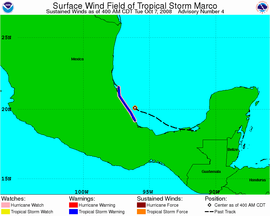
Good thing it didn't do the climatalogical norm and head into the Gulf. To think this track suggests even Texas could have been hit.
Good thing it didn't do the climatalogical norm and head into the Gulf. To think this track suggests even Texas could have been hit.
0 likes
-
AnnularCane

- S2K Supporter

- Posts: 2634
- Joined: Thu Jun 08, 2006 9:18 am
- Location: Wytheville, VA
Re:
DESTRUCTION5 wrote:MINIATURE MARCO HAS MAINTAINED ONE SMALL COLD-TOPPED THUNDERSTORM
CLUSTER...ABOUT THE SIZE OF THE STATE OF DELAWARE...OVER THE
LOW-LEVEL CENTER. THEREFORE...THE INITIAL INTENSITY IS BEING KEPT
AT 55 KT IN LINE WITH THE LAST AIR FORCE RECON DATA...EVEN THOUGH
DVORAK SATELLITE CLASSIFICATIONS ARE T2.0/30 KT FROM BOTH TAFB AND
SAB. I HAVE WORKED SOME TINY TYPHOONS IN THE WESTERN PACIFIC
BEFORE...BUT HORIZONTALLY-CHALLENGED MARCO COULD BE THE SMALLEST
TROPICAL CYCLONE ON RECORD
ON RECORD....
They're really rubbing it in.
0 likes

-
MGC

- S2K Supporter
- Posts: 5792
- Joined: Sun Mar 23, 2003 9:05 pm
- Location: Pass Christian MS, or what is left.
Re: ATL: Marco : Tropical Storm - Discussion
Hopefully Marco will not develope a Napoleon complex due to his diminutive size, obviously a male thing.....anyway, the CDO of Marco only spans 1 degree or about 60 NM. This could set a record for small.....MGC
0 likes

-
Epsilon_Fan

- Category 1

- Posts: 353
- Joined: Fri Jan 13, 2006 1:03 pm
- Location: Charleston, SC
Re: ATL: Marco : Tropical Storm - Discussion
Geez, Micro looks even smaller now... I wonder what he has in store for the next 12-24 hrs
0 likes

-
TheEuropean

- Professional-Met

- Posts: 1793
- Age: 58
- Joined: Tue Sep 20, 2005 3:17 pm
- Location: Voerde, Germany
- Contact:
-
Category 5

- Category 5
- Posts: 10074
- Age: 34
- Joined: Sun Feb 11, 2007 10:00 pm
- Location: New Brunswick, NJ
- Contact:
Re: ATL: Marco : Tropical Storm - Discussion
MARCO IS AN EXTREMELY SMALL TROPICAL CYCLONE. TROPICAL STORM FORCE
WINDS ONLY EXTEND OUTWARD UP TO 15 MILES...30 KM FROM THE CENTER.
Get out the record book folks, we have a new entry.
Heck, they could get away with a Severe Thunderstorm Warning at this point.
WINDS ONLY EXTEND OUTWARD UP TO 15 MILES...30 KM FROM THE CENTER.
Get out the record book folks, we have a new entry.
Heck, they could get away with a Severe Thunderstorm Warning at this point.
0 likes
Re: ATL: Marco : Tropical Storm - Discussion
Category 5 wrote:MARCO IS AN EXTREMELY SMALL TROPICAL CYCLONE. TROPICAL STORM FORCE
WINDS ONLY EXTEND OUTWARD UP TO 15 MILES...30 KM FROM THE CENTER.
Get out the record book folks, we have a new entry.
Heck, they could get away with a Severe Thunderstorm Warning at this point.
I was amazed when I read that. Why would they state this in an intermediate advisory without any new data to back it up? Extremely small is a good way to put it. If true, this is the smallest tropical cyclone ever recorded!!
If you look at the current sat images from the NRL, there are 4 thunderstorm cells near Marco and some are larger. You would never know just looking at that image that that was a 55 knot bugger. I want radar!
0 likes
-
Category 5
- Category 5
- Posts: 10074
- Age: 34
- Joined: Sun Feb 11, 2007 10:00 pm
- Location: New Brunswick, NJ
- Contact:
Re: ATL: Marco : Tropical Storm - Discussion
Wait, don't put down the record book.
MARCO IS AN EXTREMELY SMALL TROPICAL CYCLONE. TROPICAL STORM FORCE
WINDS ONLY EXTEND OUTWARD UP TO 10 MILES...20 KM FROM THE CENTER.
This is just.... wow.
At this pace, the TS winds will cover about a football field by landfall.
Even more strange, no mention of the record by the NHC.
MARCO IS AN EXTREMELY SMALL TROPICAL CYCLONE. TROPICAL STORM FORCE
WINDS ONLY EXTEND OUTWARD UP TO 10 MILES...20 KM FROM THE CENTER.
This is just.... wow.
At this pace, the TS winds will cover about a football field by landfall.
Even more strange, no mention of the record by the NHC.
0 likes
Who is online
Users browsing this forum: No registered users and 95 guests