ATL: Marco : Tropical Depression - Discussion
Moderator: S2k Moderators
-
JonathanBelles
- Professional-Met

- Posts: 11430
- Age: 33
- Joined: Sat Dec 24, 2005 9:00 pm
- Location: School: Florida State University (Tallahassee, FL) Home: St. Petersburg, Florida
- Contact:


-
Category 5

- Category 5

- Posts: 10074
- Age: 34
- Joined: Sun Feb 11, 2007 10:00 pm
- Location: New Brunswick, NJ
- Contact:
Re:
Chacor wrote:
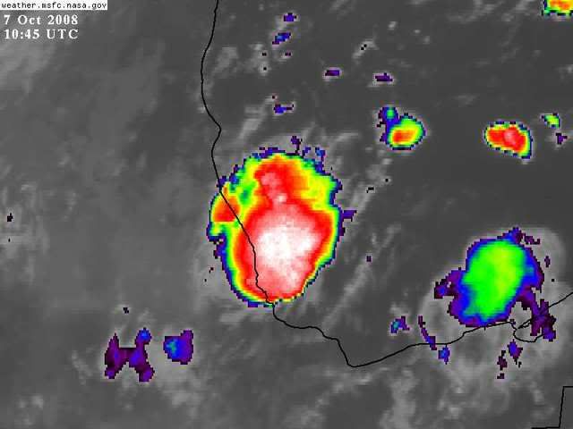
That's some pretty deep convection.
It will be a rough 10 minutes wherever this makes landfall.
0 likes

-
alan1961

- Category 2

- Posts: 767
- Joined: Mon Mar 20, 2006 11:58 am
- Location: Derby, Derbyshire, England
- Contact:
Re: ATL: Marco : Tropical Storm - Discussion
Good job this didn't have more time over water, its really giving it some convection wise just approaching the coast 
0 likes
Re:
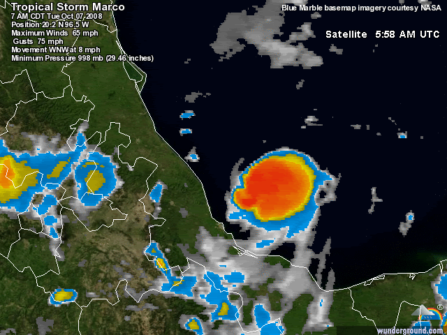
34kt winds extend out 10 miles in each direction.....or a diameter of approx 20 miles....from the center...with the core of strongest winds (50kt) to the NE and SE of the center...this will equate to approx 2-3 hour long event in the areas of the direct path (20-mile wind field, moving 8 miles per hour = 2.5 hours).
TROPICAL STORM CENTER LOCATED NEAR 20.1N 96.1W AT 07/0900Z
POSITION ACCURATE WITHIN 20 NM
ESTIMATED MINIMUM CENTRAL PRESSURE 998 MB
MAX SUSTAINED WINDS 55 KT WITH GUSTS TO 65 KT.
50 KT....... 5NE 5SE 0SW 0NW.
34 KT....... 10NE 10SE 10SW 10NW.
TROPICAL STORM CENTER LOCATED NEAR 20.1N 96.1W AT 07/0900Z
POSITION ACCURATE WITHIN 20 NM
ESTIMATED MINIMUM CENTRAL PRESSURE 998 MB
MAX SUSTAINED WINDS 55 KT WITH GUSTS TO 65 KT.
50 KT....... 5NE 5SE 0SW 0NW.
34 KT....... 10NE 10SE 10SW 10NW.
fact789 wrote:How do you have 65mph winds in an area 10 miles wide of 40mph?
Last edited by jinftl on Tue Oct 07, 2008 7:19 am, edited 1 time in total.
0 likes
-
Epsilon_Fan

- Category 1

- Posts: 353
- Joined: Fri Jan 13, 2006 1:03 pm
- Location: Charleston, SC
Re: ATL: Marco : Tropical Storm - Discussion
it looks to be "expanding" as it approaches the coast, if you can say that  The blob of thunderstorms to the east was bigger for a little while
0 likes
-
Category 5
- Category 5
- Posts: 10074
- Age: 34
- Joined: Sun Feb 11, 2007 10:00 pm
- Location: New Brunswick, NJ
- Contact:
Re: ATL: Marco : Tropical Storm - Discussion
Severe thunderstorm warning for the immediate coast. 
0 likes
-
wxman57

- Moderator-Pro Met

- Posts: 22480
- Age: 66
- Joined: Sat Jun 21, 2003 8:06 pm
- Location: Houston, TX (southwest)
Re: ATL: Marco : Tropical Storm - Discussion
I can no longer see any rotation in visible satellite loops. I think Marco may have lost its LLC overnight. Outflow boundaries are pushing away from the center in the southern half of the storm.
0 likes
-
AJC3

- Admin

- Posts: 3872
- Age: 60
- Joined: Tue Aug 31, 2004 7:04 pm
- Location: West Melbourne, Florida
- Contact:
Re: ATL: Marco : Tropical Storm - Discussion
Although not a named storm, TD #4 from 2000, which formed just off of our coast was pretty tiny as well.

0 likes
Re: ATL: Marco : Tropical Storm - Discussion
We should get a pressure reading on landfall. Must have dropped under 998 during that burst. Storm was changing gears and would have gotten stronger with more Gulf ahead if it had it.
0 likes
-
wxman57
- Moderator-Pro Met
- Posts: 22480
- Age: 66
- Joined: Sat Jun 21, 2003 8:06 pm
- Location: Houston, TX (southwest)
Re: ATL: Marco : Tropical Storm - Discussion
Sanibel wrote:We should get a pressure reading on landfall. Must have dropped under 998 during that burst. Storm was changing gears and would have gotten stronger with more Gulf ahead if it had it.
There won't be any pressure reading on landfall as there are no instruments in its path. Center, if there is one (and I doubt it) is moving ashore now. No recon today - at least no recon flying into where any center might be. It's too late.
0 likes
-
Ed Mahmoud
Re: ATL: Marco : Tropical Storm - Discussion
wxman57 wrote:Sanibel wrote:We should get a pressure reading on landfall. Must have dropped under 998 during that burst. Storm was changing gears and would have gotten stronger with more Gulf ahead if it had it.
There won't be any pressure reading on landfall as there are no instruments in its path. Center, if there is one (and I doubt it) is moving ashore now. No recon today - at least no recon flying into where any center might be. It's too late.
Never fear, GFS, Euro and Canadian all agree you'll have something else to track this time next week.
0 likes
-
cycloneye

- Admin
- Posts: 139069
- Age: 67
- Joined: Thu Oct 10, 2002 10:54 am
- Location: San Juan, Puerto Rico
Re: ATL: Marco : Tropical Storm - Discussion
No need for a plane to go.
320
WTNT33 KNHC 071442
TCPAT3
BULLETIN
TROPICAL STORM MARCO ADVISORY NUMBER 5
NWS TPC/NATIONAL HURRICANE CENTER MIAMI FL AL132008
1000 AM CDT TUE OCT 07 2008
...MARCO MAKES LANDFALL ON THE COAST OF MEXICO...
http://www.nhc.noaa.gov/text/refresh/MI ... 1442.shtml
320
WTNT33 KNHC 071442
TCPAT3
BULLETIN
TROPICAL STORM MARCO ADVISORY NUMBER 5
NWS TPC/NATIONAL HURRICANE CENTER MIAMI FL AL132008
1000 AM CDT TUE OCT 07 2008
...MARCO MAKES LANDFALL ON THE COAST OF MEXICO...
http://www.nhc.noaa.gov/text/refresh/MI ... 1442.shtml
0 likes
-
cycloneye
- Admin
- Posts: 139069
- Age: 67
- Joined: Thu Oct 10, 2002 10:54 am
- Location: San Juan, Puerto Rico
Re:
CrazyC83 wrote:My guess is 60 kt for the landfall intensity based on the improved cloud deck. We'll never know for sure since that would be in one small area.
Best Track at Post Analysis will confirm or not what you say about intensity.
0 likes
-
CrazyC83
- Professional-Met
- Posts: 33393
- Joined: Tue Mar 07, 2006 11:57 pm
- Location: Deep South, for the first time!
Re: Re:
cycloneye wrote:CrazyC83 wrote:My guess is 60 kt for the landfall intensity based on the improved cloud deck. We'll never know for sure since that would be in one small area.
Best Track at Post Analysis will confirm or not what you say about intensity.
It's almost impossible to tell though. Dvorak is useless with such a tiny storm, so we pretty much have to guess based on yesterday's Recon extrapolated.
0 likes
Who is online
Users browsing this forum: No registered users and 136 guests