ATL OMAR: Remnant Low - Discussion

Moderator: S2k Moderators

Message
Author
User avatar
Gustywind
Category 5
Category 5
Posts: 12334
Joined: Mon Sep 03, 2007 7:29 am
Location: Baie-Mahault, GUADELOUPE

Re: Re:

#641 Postby Gustywind » Thu Oct 16, 2008 8:43 am

wxman57 wrote:
Gustywind wrote:http://www.meteo.fr/temps/domtom/antill ... Tagant.jpg
We're good of another round of showers and tstorms during the next couple of hours, convection is still present in Omar's tail, swell is always dangerous in the carib coast, waves are increasing ....


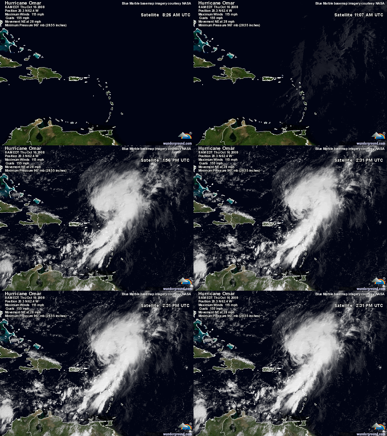
That looks more like a squall line now. It's a line of storms 750 miles long extending from 22N/58W all the way to Venezuela. Omar's core is getting to be squall-free now. It appears to be rapidly merging with the frontal boundary.

Tkanks for the info, :D i appreciate. We should have to deal with it, seems that the carib coast is beginning to experience this squall line as many reports have observed in these locations at the radio.
0 likes   

jconsor
Professional-Met
Professional-Met
Posts: 533
Joined: Mon Jun 30, 2008 9:31 pm
Location: Jerusalem, Israel
Contact:

Re: Re:

#642 Postby jconsor » Thu Oct 16, 2008 8:52 am

wxman57 wrote:
Gustywind wrote:http://www.meteo.fr/temps/domtom/antill ... Tagant.jpg
We're good of another round of showers and tstorms during the next couple of hours, convection is still present in Omar's tail, swell is always dangerous in the carib coast, waves are increasing ....


That looks more like a squall line now. It's a line of storms 750 miles long extending from 22N/58W all the way to Venezuela. Omar's core is getting to be squall-free now. It appears to be rapidly merging with the frontal boundary.


I agree that Omar has rapidly degraded on satellite loops in the past 6 hours. However, there is no front anywhere near Omar:

http://www.opc.ncep.noaa.gov/UA/Atl_Tropics.gif

A front is forecast to develop well to Omar's NW in about 48 hours:

http://www.opc.ncep.noaa.gov/shtml/A_48hrbw.gif
0 likes   

User avatar
Crostorm
Category 5
Category 5
Posts: 2060
Age: 49
Joined: Mon Dec 25, 2006 3:51 pm
Location: Croatia-Europe
Contact:

#643 Postby Crostorm » Thu Oct 16, 2008 8:56 am

Local report from ST.Kittis

Just a quick update. There's no school today. The roads are being
cleaned up and residents are asked to stay home. Some businesses
including a pharmacy and insurance company are opened today.
Oldroad bay is said to be impassable. Some houses on the coast of
Oldroad as well as Sprat Net, (a local business popular for it's local
cuisine eg. Fish, lobster etc) are reported to be badly damaged and
have boulders deposited inside them. In my area looks fine but we
have no electricity or water.
More later on.

--
Sent from my mobile device

☼ S.Vaughan

http://stormcarib.com/reports/current/stkitts.shtml
0 likes   

User avatar
Gustywind
Category 5
Category 5
Posts: 12334
Joined: Mon Sep 03, 2007 7:29 am
Location: Baie-Mahault, GUADELOUPE

#644 Postby Gustywind » Thu Oct 16, 2008 9:03 am

000
AWCA82 TJSJ 161015
RWSVI

WEATHER SUMMARY FOR THE U.S. VIRGIN ISLANDS
NATIONAL WEATHER SERVICE SAN JUAN PR
615 AM AST THU OCT 16 2008

HURRICANE OMAR WILL CONTINUE TO MOVE AWAY FROM THE LOCAL AREA
THIS MORNING. AT 5 AM THIS MORNING...THE CORE OF THE HURRICANE WAS
LOCATED NORTH OF ST. MARTIN. THIS SYSTEM PRODUCED STRONG WINDS
ACROSS SAINT CROIX AND SAINT THOMAS DURING THE OVERNIGHT HOURS.
THE AUTOMATED SURFACE OBSERVING SYSTEM IN SAINT CROIX REPORTED
SUSTAINED WINDS GUST OF 48 MPH...WITH A GUST OF 62 MPH...MEANWHILE
IN SAINT THOMAS...SUSTAINED WIND OF 33MPH...WITH A WIND GUST OF 49
MPH.

SCATTERED SHOWERS ASSOCIATED WITH THE CIRCULATION OF OMAR WILL
AFFECT THE LOCAL AREA FROM TIME TO TIME...DURING THE MORNING AND
AFTERNOON HOURS.

MARINE CONDITIONS WILL IMPROVE DURING THE DAY. HOWEVER..A SMALL
CRAFT ADVISORY CONTINUES IN EFFECT DUE TO HIGH SEAS AND WINDS
ACROSS THE COASTAL WATERS.

$$
0 likes   

Sanibel
Category 5
Category 5
Posts: 10348
Joined: Mon Aug 30, 2004 11:06 pm
Location: Offshore SW Florida

Re: ATL OMAR: Hurricane - Discussion

#645 Postby Sanibel » Thu Oct 16, 2008 9:38 am

Thanks wx57. Anguilla lucked out and missed the worst winds by 10-12 miles. Graph says 70-90mph on Anguilla.

Dog Island got one level below maximum but no one was there to witness it.


Some hurricane season this year.
0 likes   

User avatar
HURAKAN
Professional-Met
Professional-Met
Posts: 46086
Age: 37
Joined: Thu May 20, 2004 4:34 pm
Location: Key West, FL
Contact:

#646 Postby HURAKAN » Thu Oct 16, 2008 9:39 am

Image
0 likes   

User avatar
HURAKAN
Professional-Met
Professional-Met
Posts: 46086
Age: 37
Joined: Thu May 20, 2004 4:34 pm
Location: Key West, FL
Contact:

#647 Postby HURAKAN » Thu Oct 16, 2008 9:41 am

Image

Wow, exposed?!?!? Omar learns that the higher you go up, the harder you fall down!!!
0 likes   

User avatar
wxman57
Moderator-Pro Met
Moderator-Pro Met
Posts: 22472
Age: 66
Joined: Sat Jun 21, 2003 8:06 pm
Location: Houston, TX (southwest)

Re: Re:

#648 Postby wxman57 » Thu Oct 16, 2008 9:42 am

jconsor wrote:
I agree that Omar has rapidly degraded on satellite loops in the past 6 hours. However, there is no front anywhere near Omar:

http://www.opc.ncep.noaa.gov/UA/Atl_Tropics.gif

A front is forecast to develop well to Omar's NW in about 48 hours:

http://www.opc.ncep.noaa.gov/shtml/A_48hrbw.gif


Just because the front was dropped from the analysis doesn't mean it's not there. Take a look at the temps aloft. There's a frontal boundary above the surface. That trof analyzed on the first image is actually a cold front, I'd argue. There are brisk northerly winds behind it though the temperatures aren't so cold so far from the U.S. There's a 6C temperature drop across it at 850mb, though.

http://www.nco.ncep.noaa.gov/pmb/nwprod ... 0_006m.gif
Last edited by wxman57 on Thu Oct 16, 2008 9:44 am, edited 1 time in total.
0 likes   

User avatar
Just Joshing You
Category 2
Category 2
Posts: 512
Joined: Sat Nov 03, 2007 10:29 am
Location: Nova Scotia

#649 Postby Just Joshing You » Thu Oct 16, 2008 9:42 am

I'm shocked to read wxman57 posting that stuff...


and also shocked to see what kind of divine intervention made Omar take what is arguably the best possible track that was physically possible for him to take.
0 likes   

User avatar
Gustywind
Category 5
Category 5
Posts: 12334
Joined: Mon Sep 03, 2007 7:29 am
Location: Baie-Mahault, GUADELOUPE

#650 Postby Gustywind » Thu Oct 16, 2008 9:43 am

DATE/TIME LAT LON CLASSIFICATION STORM
16/1145 UTC 19.1N 62.9W T4.5/5.5 OMAR -- Atlantic Ocean
0 likes   

User avatar
Gustywind
Category 5
Category 5
Posts: 12334
Joined: Mon Sep 03, 2007 7:29 am
Location: Baie-Mahault, GUADELOUPE

#651 Postby Gustywind » Thu Oct 16, 2008 9:48 am

- Updates from the Islands -
- - St.Maarten/St.Martin - -
- Beacon Hill
From: Gert van Dijken <gert at vandijken.com>
Date: Thu, 16 Oct 2008 10:29:40 -0400 (EDT)

I have heard from several people on St.Maarten. Cell phones are working. That's the good news. There is still a curfew till noon or 1PM, so that they can repair downed power lines etc. The following I heard directly from people on the island, but remember that there are always a lot of rumours and sensational stories right after the storm. Apparently the Beacon Hill area sustained considerable damage, esp. the oceanfront properties. The Sunset Bar for example had a lot of damage. Bavaria lost its roof they said on the radio.


Otherwise things seem not too bad. In Cole Bay minimal damage, just clean up (coconuts still on the trees), houses/condos on Simpson Bay ok, Oyster Pond minimal damage. Seems that Beacon Hill got the worst.

Map of the island: http://gobeach.com/sxmmap.htm


*
**
*** Gert van Dijken ( gert at vandijken.com )
**** Caribbean Hurricane Network - http://stormcarib.com
0 likes   

Ed Mahmoud

Re: ATL OMAR: Hurricane - Discussion

#652 Postby Ed Mahmoud » Thu Oct 16, 2008 9:50 am

In my long non-career as an amateur, I have never seen such a perfect looking major monster get torn apart so quickly before.
0 likes   

User avatar
HURAKAN
Professional-Met
Professional-Met
Posts: 46086
Age: 37
Joined: Thu May 20, 2004 4:34 pm
Location: Key West, FL
Contact:

#653 Postby HURAKAN » Thu Oct 16, 2008 9:51 am

Image
0 likes   

User avatar
Crostorm
Category 5
Category 5
Posts: 2060
Age: 49
Joined: Mon Dec 25, 2006 3:51 pm
Location: Croatia-Europe
Contact:

#654 Postby Crostorm » Thu Oct 16, 2008 9:52 am

- Updates from the Islands -
- - Antigua - -

- More on antigua

* From: "Martha Watkins Gilkes" <gilkesm at candw.ag>
* Date: Thu, 16 Oct 2008 10:48:00 -0400

Been very serious flooding island wide. Rain still pouring ...wind dying a bit
... power out island wide ..but radio just back on .. Prime Minister just on
radio on tour of serious flood areas and has been major rescue of boats going
into residental areas to rescue people..pigotts is worst hit .
My own house had big flooding under doors as the water rose ....
Also many elec poles down island wide with work going on now but it will be
slow....i think it is finally safe from lightening for me to go out to my
neighbors homes to see if all safe ...will report back later today ..but no
internet only communication on my cell .. So concerned about those in st
croix etc who got Cat 3 hit...we were lucky with wind but still have
serious water flood damage ... Evyone will have to roll up or sleeves and
pull together ...
radio just reported looting in town but police now on scene ..
martha

Martha Watkins Gilkes
from Palm
Paradise accomadations: http://www.antiguanice.com/treetops
268 460 4423 phone
268 460 4424 fax

http://stormcarib.com/reports/current/antigua.shtml
0 likes   

User avatar
HURAKAN
Professional-Met
Professional-Met
Posts: 46086
Age: 37
Joined: Thu May 20, 2004 4:34 pm
Location: Key West, FL
Contact:

#655 Postby HURAKAN » Thu Oct 16, 2008 9:56 am

Repeating the 1100 am AST position...20.2 N...61.3 W. Movement
toward...northeast near 23 mph. Maximum sustained winds...85 mph.
Minimum central pressure...980 mb.

Going down very quickly, 85 mph.
0 likes   

CrazyC83
Professional-Met
Professional-Met
Posts: 33391
Joined: Tue Mar 07, 2006 11:57 pm
Location: Deep South, for the first time!

#656 Postby CrazyC83 » Thu Oct 16, 2008 10:02 am

It's sitting under 40 kt of mid-level shear and increasing upper-level shear. However, I don't think it is as weak as thought, since storms in such environments often tend to bring deceptively strong winds...
0 likes   

User avatar
Gustywind
Category 5
Category 5
Posts: 12334
Joined: Mon Sep 03, 2007 7:29 am
Location: Baie-Mahault, GUADELOUPE

#657 Postby Gustywind » Thu Oct 16, 2008 10:03 am

- Updates from the Islands -
- - Dominica - -
- Just Been Smacked.
From: "Tom Fullbrook" <fullbrookt at gmail.com>
Date: Thu, 16 Oct 2008 10:54:51 -0400

Good morning everyone,
Plenty of rain, gusty wind, thunder and lightening.
Sea swells up to 12ft. The area of Pottersfield and Fond Cole
on the west coast have been hit bad. These areas are small
fishing communities. A lot of small boats and equipment have
been washed out to sea. The small shacks built on the beach to
house the boats have all been swept away. Lots of debris swept
out to sea. We watched the debris being swept past. It included
telegraph poles, trees and a fishing boat. The weather advisory
this morning said no sever weather would affect the island.
Someone didn't look out their window this morning.
One person reported with slight injuries, trying to get his boat out
of the water. Ross universerty closed. Govt asking that shops and
buisness's close for the day.
The jetty for the cruise ships at Roseau has been damaged.
The ferry terminal has been damaged.
Hope everyone is safe and well. Any more devolopment
will let you know.


Tommiegirl.
0 likes   

User avatar
Crostorm
Category 5
Category 5
Posts: 2060
Age: 49
Joined: Mon Dec 25, 2006 3:51 pm
Location: Croatia-Europe
Contact:

#658 Postby Crostorm » Thu Oct 16, 2008 10:06 am

LIAT issues further update as a result of flood related airport closure in Antigua

http://www.anguillalife.com/news/storie ... l/3054.php
0 likes   

User avatar
Just Joshing You
Category 2
Category 2
Posts: 512
Joined: Sat Nov 03, 2007 10:29 am
Location: Nova Scotia

#659 Postby Just Joshing You » Thu Oct 16, 2008 10:07 am

Is this the most a non cat 4 or cat 5 has weakened in 1 advisory? Not including landfalling storms. I also don't think it's nearly as weak as they think, but I'm not a professional.
0 likes   

CrazyC83
Professional-Met
Professional-Met
Posts: 33391
Joined: Tue Mar 07, 2006 11:57 pm
Location: Deep South, for the first time!

#660 Postby CrazyC83 » Thu Oct 16, 2008 10:12 am

Lili weakened from a Cat 4 to Cat 1 in like 8 hours ahead of landfall. This reminds me of Lili. Unfortunately, the weakening was post-land impacts, although fortunately he took the path of least resistance.
0 likes   


Return to “2008”

Who is online

Users browsing this forum: No registered users and 17 guests