Hope that you're safe HUC. Wet weather conditions will continue as a showers and tstorms should bring a deterioration of the weather Tuesday night, damn
ATL OMAR: Remnant Low - Discussion
Moderator: S2k Moderators
-
CrazyC83
- Professional-Met

- Posts: 33393
- Joined: Tue Mar 07, 2006 11:57 pm
- Location: Deep South, for the first time!
Re: ATL: INVEST 98L - Discussion
cycloneye wrote:Ed Mahmoud wrote:Wasn't there talk of Puerto Rico and vicinity being too dry back in June?
I see that isn't an issue anymore.
At June,we were almost at the point of rationing water.But how things change,In mid Septembert we had the historic massive floods and now we may have if not that same amount,maybe more than that.
That was all thanks to the tropics as well - mainly Kyle (or what would become Kyle).
0 likes
-
cycloneye

- Admin

- Posts: 139086
- Age: 67
- Joined: Thu Oct 10, 2002 10:54 am
- Location: San Juan, Puerto Rico
Re: ATL: INVEST 98L - Discussion
729
ABNT20 KNHC 122354
TWOAT
TROPICAL WEATHER OUTLOOK
NWS TPC/NATIONAL HURRICANE CENTER MIAMI FL
800 PM EDT SUN OCT 12 2008
FOR THE NORTH ATLANTIC...CARIBBEAN SEA AND THE GULF OF MEXICO...
THE NATIONAL HURRICANE CENTER HAS INITIATED ADVISORIES ON TROPICAL
STORM NANA...LOCATED ABOUT 925 MILES WEST OF THE CAPE VERDE
ISLANDS.
 THE AREA OF LOW PRESSURE CENTERED A COUPLE HUNDERD MILES
SOUTH-SOUTHWEST OF PUERTO RICO HAS CHANGED LITTLE IN ORGANIZATION
OVER THE PAST SEVERAL HOURS. UPPER-LEVEL SOUTHWESTERLY WINDS...
WHICH HAVE BEEN HINDERING DEVELOPMENT...ARE FORECAST TO DIMINISH
SLIGHTLY OVER THE NEXT DAY OR SO...AND THIS SYSTEM HAS THE
POTENTIAL TO BECOME A TROPICAL DEPRESSION TOMORROW. IF
NECESSARY...AN AIR FORCE RESERVE UNIT RECONNAISSANCE AIRCRAFT WILL
INVESTIGATE THE SYSTEM TOMORROW AFTERNOON. REGARDLESS OF WHETHER
OR NOT THE SYSTEM BECOMES A TROPICAL CYCLONE...HEAVY RAINS
ASSOCIATED WITH THE LOW WILL AFFECT PUERTO RICO AND PORTIONS OF THE
LEEWARD ISLANDS OVER THE NEXT FEW DAYS. IN SOME AREAS THESE RAINS
COULD CAUSE FLASH FLOODS. FOR INFORMATION SPECIFIC TO YOUR
AREA...PLEASE CONSULT STATEMENTS ISSUED BY YOUR LOCAL WEATHER
OFFICE.
ELSEWHERE...TROPICAL CYCLONE FORMATION IS NOT EXPECTED DURING THE
NEXT 48 HOURS.
PUBLIC ADVISORIES ON NANA ARE ISSUED UNDER WMO HEADER WTNT34
AND UNDER AWIPS HEADER MIATCPAT4. FORECAST/ADVISORIES ON
NANA ARE ISSUED UNDER WMO HEADER WTNT24 AND UNDER AWIPS
HEADER MIATCMAT4.
$$
FORECASTER FRANKLIN

ABNT20 KNHC 122354
TWOAT
TROPICAL WEATHER OUTLOOK
NWS TPC/NATIONAL HURRICANE CENTER MIAMI FL
800 PM EDT SUN OCT 12 2008
FOR THE NORTH ATLANTIC...CARIBBEAN SEA AND THE GULF OF MEXICO...
THE NATIONAL HURRICANE CENTER HAS INITIATED ADVISORIES ON TROPICAL
STORM NANA...LOCATED ABOUT 925 MILES WEST OF THE CAPE VERDE
ISLANDS.
SOUTH-SOUTHWEST OF PUERTO RICO HAS CHANGED LITTLE IN ORGANIZATION
OVER THE PAST SEVERAL HOURS. UPPER-LEVEL SOUTHWESTERLY WINDS...
WHICH HAVE BEEN HINDERING DEVELOPMENT...ARE FORECAST TO DIMINISH
SLIGHTLY OVER THE NEXT DAY OR SO...AND THIS SYSTEM HAS THE
POTENTIAL TO BECOME A TROPICAL DEPRESSION TOMORROW. IF
NECESSARY...AN AIR FORCE RESERVE UNIT RECONNAISSANCE AIRCRAFT WILL
INVESTIGATE THE SYSTEM TOMORROW AFTERNOON. REGARDLESS OF WHETHER
OR NOT THE SYSTEM BECOMES A TROPICAL CYCLONE...HEAVY RAINS
ASSOCIATED WITH THE LOW WILL AFFECT PUERTO RICO AND PORTIONS OF THE
LEEWARD ISLANDS OVER THE NEXT FEW DAYS. IN SOME AREAS THESE RAINS
COULD CAUSE FLASH FLOODS. FOR INFORMATION SPECIFIC TO YOUR
AREA...PLEASE CONSULT STATEMENTS ISSUED BY YOUR LOCAL WEATHER
OFFICE.
ELSEWHERE...TROPICAL CYCLONE FORMATION IS NOT EXPECTED DURING THE
NEXT 48 HOURS.
PUBLIC ADVISORIES ON NANA ARE ISSUED UNDER WMO HEADER WTNT34
AND UNDER AWIPS HEADER MIATCPAT4. FORECAST/ADVISORIES ON
NANA ARE ISSUED UNDER WMO HEADER WTNT24 AND UNDER AWIPS
HEADER MIATCMAT4.
$$
FORECASTER FRANKLIN
0 likes
-
Derek Ortt
-
cycloneye
- Admin
- Posts: 139086
- Age: 67
- Joined: Thu Oct 10, 2002 10:54 am
- Location: San Juan, Puerto Rico
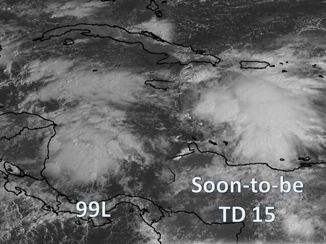
Re: ATL: INVEST 98L - Discussion=8 PM TWO=Code Red
Best Track at 00:00 UTC has it as a Tropical Low.
AL, 98, 2008101300, , BEST, 0, 157N, 686W, 30, 1006, LO
AL, 98, 2008101300, , BEST, 0, 157N, 686W, 30, 1006, LO
0 likes

-
cycloneye
- Admin
- Posts: 139086
- Age: 67
- Joined: Thu Oct 10, 2002 10:54 am
- Location: San Juan, Puerto Rico
Re: ATL: INVEST 98L - Discussion
12/2345 UTC 15.3N 68.2W T1.5/1.5 98L -- Atlantic Ocean
http://www.ssd.noaa.gov/PS/TROP/positions.html
http://www.ssd.noaa.gov/PS/TROP/positions.html
0 likes

-
CrazyC83
- Professional-Met
- Posts: 33393
- Joined: Tue Mar 07, 2006 11:57 pm
- Location: Deep South, for the first time!
Re: ATL: INVEST 98L - Discussion=8 PM TWO=Code Red
cycloneye wrote:Best Track at 00:00 UTC has it as a Tropical Low.
AL, 98, 2008101300, , BEST, 0, 157N, 686W, 30, 1006, LO
What's the difference between a disturbance and a tropical low?
0 likes
-
cycloneye
- Admin
- Posts: 139086
- Age: 67
- Joined: Thu Oct 10, 2002 10:54 am
- Location: San Juan, Puerto Rico
Re: ATL: INVEST 98L - Discussion
msbee wrote:Luis, how is the weather in PR?
it's dry here.
I haved been posting watches and warnings tonight in the thread at the top of forum.The situation is starting to get bad,as we haved not recuperated totally from that big massive flooding event of September.
0 likes
-
bvigal

- S2K Supporter

- Posts: 2275
- Joined: Sun Jul 24, 2005 8:49 am
- Location: British Virgin Islands
- Contact:
Re: ATL: INVEST 98L - Discussion
We had some heafty squalls come through here earlier, and my porch furniture was running from one side to the other out there (40mph gusts), course I am at 1000ft.
Now that we're in the "red", I think we need to watch this thing. Seems the models like to turn it around and bring it right over us, except of course for CLIP and shallow BAM, no surprise they don't agree.


In fact, looking latest sat loop, http://www.ssd.noaa.gov/goes/flt/t2/loop-ft.html, I'm not sure it will get as far west as they show, it looks like about 66.5W now.
Now that we're in the "red", I think we need to watch this thing. Seems the models like to turn it around and bring it right over us, except of course for CLIP and shallow BAM, no surprise they don't agree.
In fact, looking latest sat loop, http://www.ssd.noaa.gov/goes/flt/t2/loop-ft.html, I'm not sure it will get as far west as they show, it looks like about 66.5W now.
0 likes
-
cycloneye
- Admin
- Posts: 139086
- Age: 67
- Joined: Thu Oct 10, 2002 10:54 am
- Location: San Juan, Puerto Rico
Re: ATL: INVEST 98L - Discussion
A Tropical Cyclone Formation Alert has been issued:
TROPICAL CYCLONE FORMATION ALERT 130300Z OCT 08//
WTNT02 KNGU 130300
1. FORMATION OF A SIGNIFICANT TROPICAL CYCLONE IS POSSIBLE WITHIN
100 NM EITHER SIDE OF A LINE FROM 15.8N 68.5W TO 17.5N 70.5W
WITHIN THE NEXT 12 TO 24 HOURS. AVAILABLE DATA DOES NOT JUSTIFY
ISSUANCE OF NUMBERED TROPICAL CYCLONE WARNINGS AT THIS TIME.
WINDS IN THE AREA ARE ESTIMATED TO BE 20 TO 25 KNOTS. THE SYSTEM
IS MOVING NORTHWESTWARD AT 10 KNOTS.
2. REMARKS: THE AREA OF LOW PRESSURE IS CURRENTLY ENCOUNTERING 20 TO 30 KNOTS
OF SOUTHWESTERLY WIND SHEAR. THE AREA OF LOW PRESSURE WILL SLOWLY TRACK
NORTHWESTWARD TOWARDS AREA OF LESS THAN 10 KNOTS OF SOUTHWESTERLY WIND SHEAR
BY TOMORROW AFTERNOON. EXPECT UPPER LEVEL ENVIRONMENT TO BECOME MORE CONDUCTIVE
FOR TROPICAL CYCLONE FORMATION. SEA SURFACE TEMPERATURE OF 82 TO 85F FURTHER
ENHANCES TROPICAL CYCLONE DEVELOPMENT OVER THE NEXT 24 TO 48 HOURS.
3. THIS ALERT WILL BE REISSUED, UPGRADED TO WARNING OR CANCELLED BY 140300Z.//
0 likes

Re: ATL: INVEST 98L - Discussion - TCFA
the center is not elongated. Its out running the convection as it moves west. Shear taken its toll. Clearly see the LLC moving west aways from the convection. Maybe this has mulitple centers but definitly a LLC moving west with the low level flow currently.
15.6N 69w
http://www.ssd.noaa.gov/goes/flt/t2/loop-vis.html
15.6N 69w
http://www.ssd.noaa.gov/goes/flt/t2/loop-vis.html
0 likes
-
Weatherfreak000

000
ABNT20 KNHC 130530
TWOAT
TROPICAL WEATHER OUTLOOK
NWS TPC/NATIONAL HURRICANE CENTER MIAMI FL
200 AM EDT MON OCT 13 2008
FOR THE NORTH ATLANTIC...CARIBBEAN SEA AND THE GULF OF MEXICO...
THE NATIONAL HURRICANE CENTER IS ISSUING ADVISORIES ON TROPICAL
STORM NANA...LOCATED ABOUT 980 MILES WEST OF THE CAPE VERDE
ISLANDS.
THE AREA OF LOW PRESSURE CENTERED A COUPLE HUNDRED MILES
SOUTHWEST OF PUERTO RICO HAS CHANGED LITTLE IN ORGANIZATION
OVER THE PAST SEVERAL HOURS. UPPER-LEVEL SOUTHWESTERLY WINDS...
WHICH HAVE BEEN HINDERING DEVELOPMENT...ARE FORECAST TO TEMPORARILY
DIMINISH WITHIN THE NEXT 12 TO 24 HOURS...AND THIS SYSTEM HAS THE
POTENTIAL TO BECOME A TROPICAL DEPRESSION TODAY OR TONIGHT AS IT
MOVES SLOWLY WEST-NORTHWESTWARD. AN AIR FORCE RESERVE UNIT
RECONNAISSANCE AIRCRAFT IS SCHEDULED TO INVESTIGATE THE AREA THIS
AFTERNOON...IF NECESSARY. REGARDLESS OF WHETHER OR NOT THE SYSTEM
BECOMES A TROPICAL CYCLONE...HEAVY RAINS ASSOCIATED WITH THE LOW
WILL AFFECT PUERTO RICO...THE VIRGIN ISLANDS...AND PORTIONS OF THE
LEEWARD ISLANDS OVER THE NEXT FEW DAYS. IN SOME AREAS THESE RAINS
COULD CAUSE FLASH FLOODS. FOR INFORMATION SPECIFIC TO YOUR
AREA...PLEASE CONSULT STATEMENTS ISSUED BY YOUR LOCAL WEATHER
OFFICE.
ELSEWHERE...TROPICAL CYCLONE FORMATION IS NOT EXPECTED DURING THE
NEXT 48 HOURS.
PUBLIC ADVISORIES ON NANA ARE ISSUED UNDER WMO HEADER WTNT34
AND UNDER AWIPS HEADER MIATCPAT4. FORECAST/ADVISORIES ON
NANA ARE ISSUED UNDER WMO HEADER WTNT24 AND UNDER AWIPS
HEADER MIATCMAT4.
$$
FORECASTER PASCH
0 likes
-
TheEuropean

- Professional-Met
- Posts: 1793
- Age: 58
- Joined: Tue Sep 20, 2005 3:17 pm
- Location: Voerde, Germany
- Contact:
-
bvigal
- S2K Supporter
- Posts: 2275
- Joined: Sun Jul 24, 2005 8:49 am
- Location: British Virgin Islands
- Contact:
Re: ATL: INVEST 98L - Discussion
No longer see the spin farther east I saw last night, so believe the postion fix is right. Models still show a sharp turn, not good news for PR/VI.
(moved pictures to models thread)
NWS-SJU has been saying the same thing for days:
AREA FORECAST DISCUSSION
NATIONAL WEATHER SERVICE SAN JUAN PR
451 AM AST MON OCT 13 2008
.SYNOPSIS...
ACTIVE TROPICAL WAVE NOW ENTERING THE EAST CENTRAL ATLANTIC...AND A
DEVELOPING SURFACE LOW PRESSURE CENTERED SOME 200 MILES SOUTHWEST OF
PUERTO RICO RICO CONTINUED TO GENERATE EXTENSIVE AREAS OF SHOWERS
AND THUNDERSTORMS ALONG THE NORTHERN AND EAST SECTIONS OF THE SURFACE
CIRCULATION. WEAK UPPER LEVEL HIGH PRESSURE RIDGE ACROSS THE EASTERN
CARIBBEAN CONTINUED TO LIFT NORTHWARDS ACROSS THE LOCAL REGION AS
UPPER TROUGH (TUTT) LIFTED NORTH OF THE LOCAL ISLANDS AND CONTINUED
TO FILL. THIS WILL MAKE CONDITIONS MORE FAVORABLE FOR DEVELOPMENT
OF THIS SURFACE FEATURE INTO A TROPICAL CYCLONE OVER THE NEXT DAY
OR SO.
0 likes
-
Gustywind

- Category 5

- Posts: 12334
- Joined: Mon Sep 03, 2007 7:29 am
- Location: Baie-Mahault, GUADELOUPE
Our Pro Met are not so optimistic for us in Guadeloupe during the next couple of days, speaking about a sharp turn of this system over Puerto Rico or the BVI and maybe the Northeern Leewards Island....If this verifies in spite of the periphery we could experience rains and tstorms testifyng an yellow or an orange alert wednesday, but we're far away from that, one rule wait and see. Seems that very bad weather will occur on you Cycloneye, Bvigal.... be safe!!!!  and continue to monitor closely the situation.
0 likes
Who is online
Users browsing this forum: No registered users and 119 guests