ATL: INVEST 91L - Discussion

Moderator: S2k Moderators

Message
Author
User avatar
HURAKAN
Professional-Met
Professional-Met
Posts: 46086
Age: 37
Joined: Thu May 20, 2004 4:34 pm
Location: Key West, FL
Contact:

Re: Re:

#81 Postby HURAKAN » Mon Oct 20, 2008 9:04 am

Matt-hurricanewatcher wrote:When is recon going in???


Nothing yet planned.
0 likes   

User avatar
HURAKAN
Professional-Met
Professional-Met
Posts: 46086
Age: 37
Joined: Thu May 20, 2004 4:34 pm
Location: Key West, FL
Contact:

Re: ATL: INVEST 91L - Discussion

#82 Postby HURAKAN » Mon Oct 20, 2008 9:07 am

Western Caribbean disturbance 91L remaining about the same

Posted by: JeffMasters, 9:46 AM EDT on October 20, 2008
An area of disturbed weather associated with a large area of low pressure (91L) continues to fester off the coast of Belize in the Western Caribbean Sea. This morning's QuickSCAT pass revealed no surface circulation, although some rotation at higher levels of the atmosphere is apparent on satellite loops. The intensity and areal coverage of heavy thunderstorms in the disturbance increased some in the past few hours, spreading over the Cayman Islands. However pressures are not falling at present over the Western Caribbean. Wind shear is a high 20 knots.

The forecast for 91L
Wind shear is expected to remain in the 15-25 knot range over the next four days, which should allow some slow development of the disturbance. Steering currents are weak, and a slow movement west to a point near the Belize coast is possible today through Tuesday. Heavy rains will affect Belize, Mexico's eastern Yucatan Peninsula, and the Cayman Islands through Wednesday. A trough of low pressure swinging across the Midwest U.S. should be able to start pulling 91L northward or northwestward by Wednesday. Once 91L enters the Gulf of Mexico on Thursday, the trough should swing the storm to the northeast, bringing it across the west coast of Florida on Friday or Saturday. Wind shear will be very high over the Gulf of Mexico this week, in the 30-40 knot range, and I doubt 91L would be able to intensify into a hurricane in the face of that kind of shear. The 00Z (8 pm EDT) run of the GFDL model develops 91L into a tropical storm that hits Florida near Sarasota Friday morning with 50 mph winds. The 06Z (2am EDT) run of the GFS model is slower, predicting a landfall near Tampa on Saturday morning. However, this landfall may occur as a weaker subtropical storm or extratropical storm, as predicted by the latest phase space diagrams from Bob Hart at Florida State. The other reliable models do not develop 91L. NHC is giving 91L a medium (20-50% chance) of developing into a tropical depression by Wednesday, which is a reasonable forecast. It currently does not appear that 91L will interfere with the World Series baseball game scheduled to be played Thursday night in St. Petersburg, Florida. Batter up!
0 likes   

lbvbl
Tropical Storm
Tropical Storm
Posts: 119
Joined: Fri Aug 15, 2008 8:24 am

Re: ATL: INVEST 91L - Discussion

#83 Postby lbvbl » Mon Oct 20, 2008 9:09 am

GFDL has shifted slightly south... didnt it have this hitting the panhandle yesterday?
0 likes   

Sanibel
Category 5
Category 5
Posts: 10348
Joined: Mon Aug 30, 2004 11:06 pm
Location: Offshore SW Florida

Re: ATL: INVEST 91L - Discussion

#84 Postby Sanibel » Mon Oct 20, 2008 9:12 am

Looks like it ducked into Honduras by the coast.
0 likes   

User avatar
Blown Away
S2K Supporter
S2K Supporter
Posts: 9861
Joined: Wed May 26, 2004 6:17 am

Re: ATL: INVEST 91L - Discussion

#85 Postby Blown Away » Mon Oct 20, 2008 9:12 am

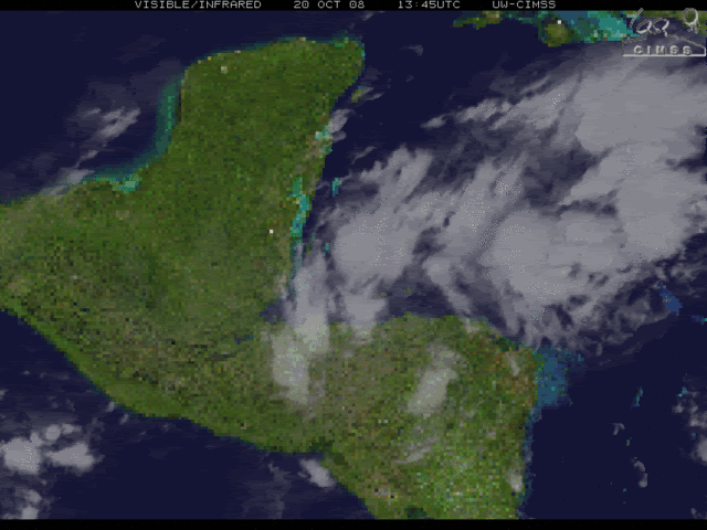
kpost wrote:with that being the possible center, it is very close to land. What direction is it currently heading, in the loop it seems to stand still? Plus if it heads North now will it organize quickly due to high SST's and low shear?

Edit:

Blown_away,

with the models going completely over my house, i am wondering if it does hit the west coast as an 80mph cane, how much punch could it have when it passes my house (brevard county Barrier Island). My neighbor told me we don't flood and fema (my block is one of 5 that sit slightly higher)says the same thing but during fay i had water to my front door and a river through my garage. I also was wondering if we get hit with a backdoor cane when it reaches the atlantic will we feel more due to being on the island. Sorry new to florida, i am used to lake effect snow.


If this system does develope and move over Florida it will be moving quickly as a trough will be kicking it out to sea. Intensity is hard to predict, Wilma was at 125 mph at Everglades City and brought 100 mph gusts to Hobe Sound. The models are shifting E w/ each run and with the trough coming the right side of this potential system will have the bad weather and the left should be weaker/drier.
0 likes   

User avatar
Blown Away
S2K Supporter
S2K Supporter
Posts: 9861
Joined: Wed May 26, 2004 6:17 am

Re: ATL: INVEST 91L - Discussion

#86 Postby Blown Away » Mon Oct 20, 2008 9:14 am

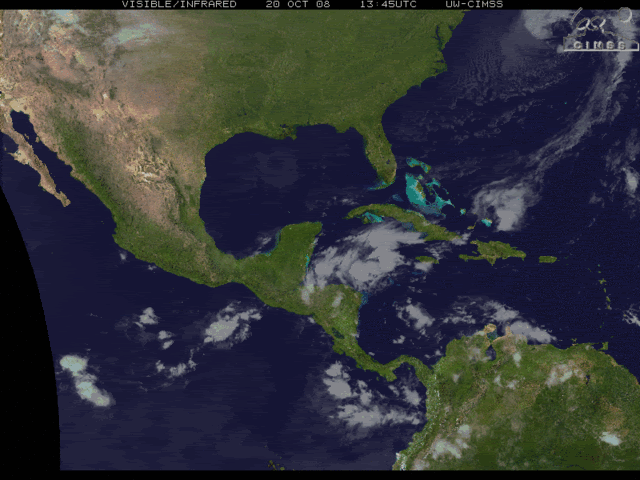
lbvbl wrote:GFDL has shifted slightly south... didnt it have this hitting the panhandle yesterday?


Landfalled between Cedar Key and Tampa and out near Daytona, now it landfalls near Sarasota and out near the Cape.
0 likes   

User avatar
HURAKAN
Professional-Met
Professional-Met
Posts: 46086
Age: 37
Joined: Thu May 20, 2004 4:34 pm
Location: Key West, FL
Contact:

Re: Re:

#87 Postby HURAKAN » Mon Oct 20, 2008 9:19 am

HURAKAN wrote:
Matt-hurricanewatcher wrote:When is recon going in???


Nothing yet planned.


NOUS42 KNHC 201330
WEATHER RECONNAISSANCE FLIGHTS
CARCAH, NATIONAL HURRICANE CENTER, MIAMI, FL.
0930 AM EDT MON 20 OCTOBER 2008
SUBJECT: TROPICAL CYCLONE PLAN OF THE DAY (TCPOD)
VALID 21/1100Z TO 22/1100Z OCTOBER 2008
TCPOD NUMBER.....08-142

I. ATLANTIC REQUIREMENTS
1. NEGATIVE RECONNAISSANCE REQUIREMENTS.
2. OUTLOOK FOR SUCCEEDING DAY.....NEGATIVE.

II. PACIFIC REQUIREMENTS
1. NEGATIVE RECONNAISSANCE REQUIREMENTS.
2. SUCCEEDING DAY OUTLOOK.....NEGATIVE.
JWP
0 likes   

Sanibel
Category 5
Category 5
Posts: 10348
Joined: Mon Aug 30, 2004 11:06 pm
Location: Offshore SW Florida

Re: ATL: INVEST 91L - Discussion

#88 Postby Sanibel » Mon Oct 20, 2008 9:21 am

Model trend is south (stronger). Wouldn't be surprised if it keeps going south. If this shoots the channel over the Loop Current we could see more intensity (if it forms).
0 likes   

User avatar
HURAKAN
Professional-Met
Professional-Met
Posts: 46086
Age: 37
Joined: Thu May 20, 2004 4:34 pm
Location: Key West, FL
Contact:

#89 Postby HURAKAN » Mon Oct 20, 2008 9:28 am

Best Track 12z:

AL, 91, 2008102012, , BEST, 0, 170N, 870W, 25, 1009
0 likes   

User avatar
kpost
Tropical Storm
Tropical Storm
Posts: 101
Age: 47
Joined: Sun Jul 06, 2008 10:52 am
Location: Indialantic, Florida (Ohio 4now)

Re: ATL: INVEST 91L - Discussion

#90 Postby kpost » Mon Oct 20, 2008 9:50 am

With the coldest cloud tops so NE of the center could the center relocate, or is this all because or shear?

:cold:
Image

Edited to add sea temps

Image
Image
0 likes   

User avatar
Blown Away
S2K Supporter
S2K Supporter
Posts: 9861
Joined: Wed May 26, 2004 6:17 am

Re: ATL: INVEST 91L - Discussion

#91 Postby Blown Away » Mon Oct 20, 2008 10:10 am

I'm seeing an improving system this morning, I know the best track is 17N/87W, but I'm seeing the circulation center near 16.5N/86W drifting NW. The convection is starting top build along the SW side of the circulation. The entire envelope has good curvature and once 91L moves a bit farther N away from the coast it should improve even more.
0 likes   

User avatar
gatorcane
S2K Supporter
S2K Supporter
Posts: 23499
Age: 46
Joined: Sun Mar 13, 2005 3:54 pm
Location: Boca Raton, FL

Re: ATL: INVEST 91L - Discussion

#92 Postby gatorcane » Mon Oct 20, 2008 10:12 am

Blown_away wrote:I'm seeing an improving system this morning, I know the best track is 17N/87W, but I'm seeing the circulation center near 16.5N/86W drifting NW. The convection is starting top build along the SW side of the circulation. The entire envelope has good curvature and once 91L moves a bit farther N away from the coast it should improve even more.


The posts in this forum are NOT official forecast and should not be used as such. They are just the opinion of the poster and may or may not be backed by sound meteorological data. They are NOT endorsed by any professional institution or storm2k.org. For official information, please refer to the NHC and NWS products.


Indeed, I'm a bit surprised I don't see more Floridians on this board, the threat of a tropical system impacting the state is increasing ---

prediction: code red within 24 hours and many more storm2kers checking in over the next couple of days.
0 likes   

User avatar
AdamFirst
S2K Supporter
S2K Supporter
Posts: 2487
Age: 34
Joined: Thu Aug 14, 2008 10:54 am
Location: Port Saint Lucie, FL

Re: ATL: INVEST 91L - Discussion

#93 Postby AdamFirst » Mon Oct 20, 2008 10:18 am

gatorcane wrote:Indeed, I'm a bit surprised I don't see more Floridians on this board, the threat of a tropical system impacting the state is increasing


I'm allllways watching :lol:

Ensured to keep an eye on this thing....it could be Wilma, the Sequel...but let's not jump the gun here either
0 likes   

User avatar
HURAKAN
Professional-Met
Professional-Met
Posts: 46086
Age: 37
Joined: Thu May 20, 2004 4:34 pm
Location: Key West, FL
Contact:

#94 Postby HURAKAN » Mon Oct 20, 2008 10:21 am

There is certainly a circulation very close to Honduras, very likely in the mid-levels. Convection is developing, shear is moderately favorable and the disturbance is supposed to move northward or northwestward very slowly. The WCAR is the prime area for development this late in the season and we should keep a very vigilant eye on 91L.

Loop: http://www.ssd.noaa.gov/goes/flt/t1/loop-vis.html
0 likes   

tgenius
S2K Supporter
S2K Supporter
Posts: 1159
Joined: Mon May 15, 2006 5:31 pm
Location: Miami, FL

Re: ATL: INVEST 91L - Discussion

#95 Postby tgenius » Mon Oct 20, 2008 10:28 am

Florida? Am I missing something, isn't this heading into Central America/Mexico?
0 likes   

User avatar
HURAKAN
Professional-Met
Professional-Met
Posts: 46086
Age: 37
Joined: Thu May 20, 2004 4:34 pm
Location: Key West, FL
Contact:

Re: ATL: INVEST 91L - Discussion

#96 Postby HURAKAN » Mon Oct 20, 2008 10:30 am

tgenius wrote:Florida? Am I missing something, isn't this heading into Central America/Mexico?


Have you seen the computer models?

Image
0 likes   

User avatar
HURAKAN
Professional-Met
Professional-Met
Posts: 46086
Age: 37
Joined: Thu May 20, 2004 4:34 pm
Location: Key West, FL
Contact:

#97 Postby HURAKAN » Mon Oct 20, 2008 10:35 am

Image

Image
0 likes   

User avatar
MGC
S2K Supporter
S2K Supporter
Posts: 5792
Joined: Sun Mar 23, 2003 9:05 pm
Location: Pass Christian MS, or what is left.

Re: ATL: INVEST 91L - Discussion

#98 Postby MGC » Mon Oct 20, 2008 10:46 am

MLC looks to be just west of Roatan....Seems slightly better organized this morning than last night. Look for slow development. Still thinking this will rain on my parade in Key West....MGC
0 likes   

tgenius
S2K Supporter
S2K Supporter
Posts: 1159
Joined: Mon May 15, 2006 5:31 pm
Location: Miami, FL

Re: ATL: INVEST 91L - Discussion

#99 Postby tgenius » Mon Oct 20, 2008 10:53 am

HURAKAN wrote:
tgenius wrote:Florida? Am I missing something, isn't this heading into Central America/Mexico?


Have you seen the computer models?

Image


Sandy, though it looks like South FL will be in the clear based on the current model runs.. should we be at all worried about it in Miami?
0 likes   

User avatar
gatorcane
S2K Supporter
S2K Supporter
Posts: 23499
Age: 46
Joined: Sun Mar 13, 2005 3:54 pm
Location: Boca Raton, FL

#100 Postby gatorcane » Mon Oct 20, 2008 10:55 am

:uarrow:

These models runs may change. There is no "all clear in South Florida" just yet. I can recall many systems where the computer models want to put it farther north than where the system actually ends up

Fay -- computer models had it going near tampa
Charley -- computer models had it going into Tampa
Wilma -- computer models had it going into Sarasota area

etc...

Note I'm not say the intensity will be anything like Charley or Wilma, just want to point out the track bias possibilities here.
Last edited by gatorcane on Mon Oct 20, 2008 10:57 am, edited 2 times in total.
0 likes   


Return to “2008”

Who is online

Users browsing this forum: No registered users and 45 guests