ATL: INVEST 91L - Discussion
Moderator: S2k Moderators
-
gatorcane

- S2K Supporter

- Posts: 23499
- Age: 46
- Joined: Sun Mar 13, 2005 3:54 pm
- Location: Boca Raton, FL
Re: ATL: INVEST 91L - Discussion
Good evening all, things are developing as I expected....TD 16 albeit moved into Central America, it spawned off this new low from it remnants. I'll take a closer look tomorrow AM but obviously Florida needs to closely watch this system given climatology and some of the model trends such as the GFDL that I have been looking at.
0 likes

Re:
fact789 wrote:I'm kind of hoping for something small to give us some rain and excitement. We can get all the rain we can get going into the dry season.
The heck with rain and tropical excitement; I think that the Rays are giving you guys all the excitement that you can handle.
Congrats to the Tampa Bay Rays!!!
Beat Philly!
0 likes
-
Blown Away

- S2K Supporter
- Posts: 9867
- Joined: Wed May 26, 2004 6:17 am
Re: ATL: INVEST 91L - Discussion
Sanibel wrote:Dipping towards Honduras coast now.
Yep, IMO I think the circulation center will likely be repositioned a little farther S and E of the the Best Track. I think we will be seeing the models move more N and E over the next few runs skirting or just E of the Yucatan and move generally towards Florida. I think the big question is the shear, so far it seems pretty hostile if 91L makes it to the GOM.
How about them Rays!! What a great story and a fun team to watch.
0 likes
-
Just Joshing You

- Category 2

- Posts: 512
- Joined: Sat Nov 03, 2007 10:29 am
- Location: Nova Scotia
Re: ATL: INVEST 91L - Discussion
Blown_away wrote:Sanibel wrote:Dipping towards Honduras coast now.
Yep, IMO I think the circulation center will likely be repositioned a little farther S and E of the the Best Track. I think we will be seeing the models move more N and E over the next few runs skirting or just E of the Yucatan and move generally towards Florida. I think the big question is the shear, so far it seems pretty hostile if 91L makes it to the GOM.
How about them Rays!! What a great story and a fun team to watch.
I must be one of the only people who think baseball is the most boring sport to watch. It is just so damn boring... gah I feel like I'm dying alive when I am forced to watch one.
0 likes
-
TheEuropean

- Professional-Met

- Posts: 1793
- Age: 58
- Joined: Tue Sep 20, 2005 3:17 pm
- Location: Voerde, Germany
- Contact:
-
Blown Away
- S2K Supporter
- Posts: 9867
- Joined: Wed May 26, 2004 6:17 am
Re: ATL: INVEST 91L - Discussion
0 likes
-
HURAKAN

- Professional-Met
- Posts: 46086
- Age: 37
- Joined: Thu May 20, 2004 4:34 pm
- Location: Key West, FL
- Contact:
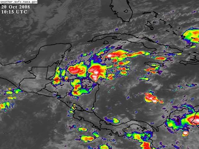
TROPICAL WEATHER OUTLOOK
NWS TPC/NATIONAL HURRICANE CENTER MIAMI FL
800 AM EDT MON OCT 20 2008
FOR THE NORTH ATLANTIC...CARIBBEAN SEA AND THE GULF OF MEXICO...
A NEARLY STATIONARY AREA OF LOW PRESSURE LOCATED OVER THE
NORTHWESTERN CARIBBEAN SEA IS PRODUCING DISORGANIZED SHOWERS AND
THUNDERSTORMS. SURFACE PRESSURES ARE RISING AND DEVELOPMENT...IF
ANY...WILL BE SLOW TO OCCUR. LOCALLY HEAVY RAINS WILL LIKELY
CONTINUE OVER PORTIONS OF HONDURAS...GUATEMALA...BELIZE...AND THE
YUCATAN PENINSULA OVER THE NEXT COUPLE OF DAYS.
ELSEWHERE...TROPICAL CYCLONE FORMATION IS NOT EXPECTED DURING THE
NEXT 48 HOURS.
$$
FORECASTER AVILA
0 likes
-
kpost

- Tropical Storm

- Posts: 101
- Age: 47
- Joined: Sun Jul 06, 2008 10:52 am
- Location: Indialantic, Florida (Ohio 4now)
Re: ATL: INVEST 91L - Discussion
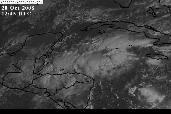
It shows some popping in this visible.
To those who know much more then I, where is your best guess at possible center?

To those who know much more then I, where is your best guess at possible center?
0 likes
-
Matt-hurricanewatcher

- Category 5

- Posts: 11649
- Age: 38
- Joined: Fri Nov 26, 2004 11:09 pm
- Location: Portland,OR
- Contact:
Re: ATL: INVEST 91L - Discussion
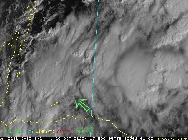
16.8/85.6 is the axis. You can see at least a MLC centered there. Nice curving starting to develop to.
0 likes
-
gatorcane
- S2K Supporter
- Posts: 23499
- Age: 46
- Joined: Sun Mar 13, 2005 3:54 pm
- Location: Boca Raton, FL
Re: ATL: INVEST 91L - Discussion
Matt-hurricanewatcher wrote:16.8/85.6 is the axis. You can see at least a MLC centered there. Nice curving starting to develop to.
Yes agreed good call on this. Its on the northern coast of Honduras at the moment:
Members can use this loop to see that MLC Matt has pointed out:
http://metofis.rsmas.miami.edu/~dortt/s ... 1_loop.gif
0 likes
-
stayawaynow
- Tropical Low

- Posts: 47
- Joined: Mon Aug 25, 2008 10:07 am
- Location: Wellington, FL.
Re: ATL: INVEST 91L - Discussion
gatorcane wrote:Matt-hurricanewatcher wrote:16.8/85.6 is the axis. You can see at least a MLC centered there. Nice curving starting to develop to.
Yes agreed good call on this. Its on the northern coast of Honduras at the moment:
Members can use this loop to see that MLC Matt has pointed out:
http://metofis.rsmas.miami.edu/~dortt/s ... 1_loop.gif
Gator, what are your thoughts on a threat to Florida?
0 likes
-
Blown Away
- S2K Supporter
- Posts: 9867
- Joined: Wed May 26, 2004 6:17 am
Re: ATL: INVEST 91L - Discussion

We have one following climatology. Looks like 91L will skirt the E coast of the Yucatan. The GFDL has a 80 mph cane going to Sarasota in about 4 days and then a 100mph cane off Carolinas. The convection is now starting to consolidate near the circulation center. It appears now there will not be as much land interaction with the Yucatan as predicted by the models last night. Fortunately the shear should limit significant strengthening if this makes it into the Gulf. There could be a TS or minimal Hurricane near Florida in about 4+ days.
0 likes
-
kpost
- Tropical Storm
- Posts: 101
- Age: 47
- Joined: Sun Jul 06, 2008 10:52 am
- Location: Indialantic, Florida (Ohio 4now)
Re: ATL: INVEST 91L - Discussion
with that being the possible center, it is very close to land. What direction is it currently heading, in the loop it seems to stand still? Plus if it heads North now will it organize quickly due to high SST's and low shear?
Edit:
Blown_away,
with the models going completely over my house, i am wondering if it does hit the west coast as an 80mph cane, how much punch could it have when it passes my house (brevard county Barrier Island). My neighbor told me we don't flood and fema (my block is one of 5 that sit slightly higher)says the same thing but during fay i had water to my front door and a river through my garage. I also was wondering if we get hit with a backdoor cane when it reaches the atlantic will we feel more due to being on the island. Sorry new to florida, i am used to lake effect snow.
0 likes
-
Matt-hurricanewatcher
- Category 5
- Posts: 11649
- Age: 38
- Joined: Fri Nov 26, 2004 11:09 pm
- Location: Portland,OR
- Contact:
Re:
Maybe a LLC. Lets see if we can see some lower level clouds then that later to confirm it. When is recon going in???
0 likes
-
Blown Away
- S2K Supporter
- Posts: 9867
- Joined: Wed May 26, 2004 6:17 am
Re: ATL: INVEST 91L - Discussion
0 likes
Who is online
Users browsing this forum: No registered users and 20 guests