Loop: http://rammb.cira.colostate.edu/ramsdis ... _floater_1
There is no question that it's becoming better organized. WOW!!!
ATL: INVEST 96L - Discussion
Moderator: S2k Moderators

Re: ATL: INVEST 96L - Discussion
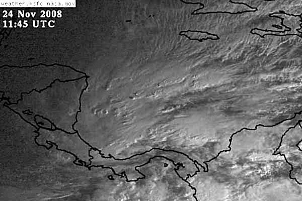
Whoa! I can't believe how this came together and bursted so close to Panama.
Behavior and shape suggests development.
Behavior and shape suggests development.
0 likes
-
HURAKAN

- Professional-Met

- Posts: 46086
- Age: 37
- Joined: Thu May 20, 2004 4:34 pm
- Location: Key West, FL
- Contact:
TROPICAL WEATHER DISCUSSION
NWS TPC/NATIONAL HURRICANE CENTER MIAMI FL
105 AM EST MON NOV 24 2008
...SPECIAL FEATURE...
IN THE SW CARIBBEAN...A 1007 MB SURFACE LOW IS CENTERED N OF
PANAMA NEAR 10N80W. LOW LEVEL CONVERGENCE IN THE VICINITY OF
THIS SURFACE LOW IS INTERACTING WITH DEEP LAYER MOISTURE OVER
THE W CARIBBEAN TO RESULT IN NUMEROUS SHOWERS AND THUNDERSTORMS
OVER THE CARIBBEAN S OF 15N W OF 77W...INCLUDING PORTIONS OF
COSTA RICA...PANAMA...AND E NICARAGUA. THIS SHOWER AND
THUNDERSTORM ACTIVITY HAS INCREASED AND BECOME BETTER ORGANIZED
OVER THE LAST DAY...AND SOME ADDITIONAL DEVELOPMENT OF THIS
SYSTEM IS POSSIBLE OVER THE NEXT COUPLE OF DAYS AS IT DRIFTS
SLOWLY WESTWARD. REGARDLESS OF WHETHER OR NOT A TROPICAL CYCLONE
FORMS...HEAVY RAINFALL AND LOCALIZED FLOODING WILL BE POSSIBLE
OVER PORTIONS OF PANAMA...COSTA RICA...AND NICARAGUA DURING THE
NEXT COUPLE OF DAYS.
0 likes
-
HURAKAN
- Professional-Met
- Posts: 46086
- Age: 37
- Joined: Thu May 20, 2004 4:34 pm
- Location: Key West, FL
- Contact:
443
ABNT20 KNHC 240600
TWOAT
TROPICAL WEATHER OUTLOOK
NWS TPC/NATIONAL HURRICANE CENTER MIAMI FL
100 AM EST MON NOV 24 2008
FOR THE NORTH ATLANTIC...CARIBBEAN SEA AND THE GULF OF MEXICO...
A BROAD LOW PRESSURE SYSTEM LOCATED JUST NORTH OF PANAMA IS
PRODUCING A LARGE AREA OF SHOWERS AND THUNDERSTORMS OVER THE
SOUTHWESTERN CARIBBEAN SEA AND ADJACENT LAND AREAS. SHOWER AND
THUNDERSTORM ACTIVITY HAS CONTINUED TO BECOME BETTER ORGANIZED...AND
A TROPICAL DEPRESSION COULD FORM IN THE NEXT DAY OR TWO IF THE
SYSTEM REMAINS OVER WATER AS IT DRIFTS SLOWLY WESTWARD. REGARDLESS
OF WHETHER OR NOT A TROPICAL CYCLONE FORMS...HEAVY RAINFALL AND
LOCALIZED FLOODING WILL BE POSSIBLE OVER PORTIONS OF PANAMA...COSTA
RICA...AND NICARAGUA DURING THE NEXT COUPLE OF DAYS.
ELSEWHERE...TROPICAL CYCLONE FORMATION IS NOT EXPECTED DURING THE
NEXT 48 HOURS.
$$
FORECASTER BRENNAN/STEWART
0 likes


-
HURAKAN
- Professional-Met
- Posts: 46086
- Age: 37
- Joined: Thu May 20, 2004 4:34 pm
- Location: Key West, FL
- Contact:
TROPICAL WEATHER DISCUSSION
NWS TPC/NATIONAL HURRICANE CENTER MIAMI FL
705 AM EST MON NOV 24 2008
...SPECIAL FEATURE...
IN THE SW CARIBBEAN...A 1007 MB SURFACE LOW IS CENTERED N OF
PANAMA NEAR 10N80W. LOW LEVEL CONVERGENCE IN THE VICINITY OF
THIS SURFACE LOW IS INTERACTING WITH DEEP LAYER MOISTURE OVER
THE W CARIBBEAN TO RESULT IN NUMEROUS SHOWERS AND THUNDERSTORMS
OVER THE CARIBBEAN S OF 15N W OF 77W...INCLUDING PORTIONS OF
COSTA RICA...PANAMA...AND E NICARAGUA. THIS SHOWER AND
THUNDERSTORM ACTIVITY CONTINUES TO BECOME BETTER ORGANIZED...
AND A TROPICAL DEPRESSION MAY FORM IN THE NEXT DAY OR TWO IF THE
SYSTEM REMAINS OVER WATER AS IT DRIFTS SLOWLY WESTWARD. HEAVY
RAINFALL AND LOCALIZED FLOODING WILL BE POSSIBLE OVER PORTIONS
OF PANAMA...COSTA RICA...AND NICARAGUA DURING THE NEXT COUPLE OF
DAYS EVEN IF NO TROPICAL CYCLONE FORMS.
0 likes
-
HURAKAN
- Professional-Met
- Posts: 46086
- Age: 37
- Joined: Thu May 20, 2004 4:34 pm
- Location: Key West, FL
- Contact:
878
ABNT20 KNHC 241145
TWOAT
TROPICAL WEATHER OUTLOOK
NWS TPC/NATIONAL HURRICANE CENTER MIAMI FL
700 AM EST MON NOV 24 2008
FOR THE NORTH ATLANTIC...CARIBBEAN SEA AND THE GULF OF MEXICO...
SHOWERS AND THUNDERSTORMS OVER THE SOUTHWESTERN CARIBBEAN SEA AND
ADJACENT LAND AREAS ARE ASSOCIATED WITH A BROAD AREA OF LOW
PRESSURE. THERE HAS BEEN LITTLE CHANGE IN ORGANIZATION DURING THE
PAST SEVERAL HOURS BUT THERE IS STILL A POTENTIAL FOR A TROPICAL
DEPRESSION TO FORM DURING THE NEXT DAY OR TWO IF THE SYSTEM REMAINS
OVER WATER. REGARDLESS OF WHETHER OR NOT A TROPICAL CYCLONE
FORMS...HEAVY RAINFALL AND LOCALIZED FLOODING WILL BE POSSIBLE OVER
PORTIONS OF PANAMA...COSTA RICA...AND NICARAGUA DURING THE NEXT
COUPLE OF DAYS.
ELSEWHERE...TROPICAL CYCLONE FORMATION IS NOT EXPECTED DURING THE
NEXT 48 HOURS.
$$
FORECASTER AVILA
0 likes
-
cycloneye

- Admin

- Posts: 139027
- Age: 67
- Joined: Thu Oct 10, 2002 10:54 am
- Location: San Juan, Puerto Rico
Re: ATL: INVEST 96L - Discussion
0 likes

-
gatorcane

- S2K Supporter

- Posts: 23499
- Age: 46
- Joined: Sun Mar 13, 2005 3:54 pm
- Location: Boca Raton, FL
Re: ATL: INVEST 96L - Discussion
Well folks, models were hinting at something in this area as far out as 10 days in advance and indeed it looks like something may try to form albeit its unlikely it will every become the monster Paloma became.
That is why I posted the thread for the SW Caribbean early last week. I really had to think about whether I wanted to post that topic or not, but I saw too many models sniffing something out in this area to not at least start a discussion on it.
What's interesting to note is that both Paloma and this area are the result of unseasonably strong cold fronts pushing south and stalling over the SW Caribbean for several days, where water temperatures are very warm. It's quite rare for cold fronts to push that far south this early in the season. Since upper-level conditions are marginally favorable to very favorable in the SW Caribbean in late October through November, its allowing formation of tropical cyclones even this late in the season.
0 likes
-
Ivanhater

- Storm2k Moderator

- Posts: 10852
- Age: 37
- Joined: Fri Jul 01, 2005 8:25 am
- Location: Pensacola
Re: ATL: INVEST 96L - Discussion
wxman57 wrote:NHC must be bored. 40-50 kts shear = not a chance
You got burned using this type of language a lot this season, and it looks like this has a good chance of developing now...perhaps bones should take a vacation next season
0 likes
-
wxman57

- Moderator-Pro Met

- Posts: 22480
- Age: 66
- Joined: Sat Jun 21, 2003 8:06 pm
- Location: Houston, TX (southwest)
Re: ATL: INVEST 96L - Discussion
Still nothing there but disorganized convection. Convection can exist in a sheared environment quite easily. But there's no surface low present. Such convergence/convection exists in this region frequently in the late season, but development doesn't occur very often. Winds are all out of the NE-E in the region. Development chances appear quite low. The only model forecasting development is the GFDL (110 kts), but it initializes it as a 42kt TS and the GFDL doesn't handle shear well. HWRF also initialized it as a 40kt TS but weakens it. Clearly, it's no TS now, just an area of convergence wit no LLC. DSHP forecasts steady weakening and dissipation.
You'll be OK with your plans, Derek.
Here's a surface analysis with satellite from 12Z.

You'll be OK with your plans, Derek.
Here's a surface analysis with satellite from 12Z.
0 likes
-
jconsor
- Professional-Met
- Posts: 533
- Joined: Mon Jun 30, 2008 9:31 pm
- Location: Jerusalem, Israel
- Contact:
Re: ATL: INVEST 96L - Discussion
There is a broad, ill-defined circulation. There are some obs which your map doesn't show that indicate winds with a westerly component:
Puerto Limon, Costa Rica reports a west wind at 13z and 14z:
http://www.wunderground.com/history/air ... story.html
A ship over Panama near 9N, 80W reported NNW winds for 3 straight hours between 8z and 11z:
http://www.sailwx.info/shiptrack/shippo ... call=ZCDF4.
This is confirmed by a personal weather station very nearby, which also showed light NNW winds:
http://www.wunderground.com/weatherstat ... =IPANAMAC2
Also, David, Panama reported light SW winds all day Sunday, though winds are calm there Monday morning: http://www.wunderground.com/history/air ... story.html
Last edited by jconsor on Mon Nov 24, 2008 9:50 am, edited 2 times in total.
0 likes

-
wxman57
- Moderator-Pro Met
- Posts: 22480
- Age: 66
- Joined: Sat Jun 21, 2003 8:06 pm
- Location: Houston, TX (southwest)
Re: ATL: INVEST 96L - Discussion
jconsor wrote:There is a broad, ill-defined circulation. There are some obs which your map doesn't show that indicate winds with a westerly component:
Puerto Limon, Costa Rica reports a west wind at 13z and 14z:
http://www.wunderground.com/history/air ... story.html
A ship over Panama near 9N, 80W reported NNW winds for 3 straight hours between 8z and 11z:
http://www.sailwx.info/shiptrack/shippo ... call=ZCDF4.
This is confirmed by a personal weather station very nearby, which also showed light NNW winds:
http://www.wunderground.com/weatherstat ... =IPANAMAC2
Also, David, Panama reported light SW winds all day Sunday, though winds are calm there Monday morning: http://www.wunderground.com/history/air ... story.html
Those stations all had wind of 5 kts or less. The Panama station is reporting 2 mph. David is on the other side of the country from the Caribbean, and its winds are also light and variable. You have to be careful interpreting such light winds as a sign of a circulation, as they're most likely the result of local effects. Panama, for example is a natural wind funnel. Wind comes in the north side and travels SSE toward the exit, thus the light NNW wind reported there.
Is see no evidence of any circulation, even a broad one. My maps show all the obs, though they're not always plotted on a single map.
0 likes
Re: ATL: INVEST 96L - Discussion
Ever notice how the NHC very rarely (if ever) uses language such as 'not a chance' or 'guaranteed'...they speak in terms of probability....even a weak td has the potential of becoming a cat 5....but the probability may be well under 1%....but there is still some very very limited chance.
As of update this morning, we have a 'code orange' on this system....meaning a 20-50% chance of development in the next 48 hours.
TROPICAL WEATHER OUTLOOK
NWS TPC/NATIONAL HURRICANE CENTER MIAMI FL
700 AM EST MON NOV 24 2008
FOR THE NORTH ATLANTIC...CARIBBEAN SEA AND THE GULF OF MEXICO...
SHOWERS AND THUNDERSTORMS OVER THE SOUTHWESTERN CARIBBEAN SEA AND
ADJACENT LAND AREAS ARE ASSOCIATED WITH A BROAD AREA OF LOW
PRESSURE. THERE HAS BEEN LITTLE CHANGE IN ORGANIZATION DURING THE
PAST SEVERAL HOURS BUT THERE IS STILL A POTENTIAL FOR A TROPICAL
DEPRESSION TO FORM DURING THE NEXT DAY OR TWO IF THE SYSTEM REMAINS
OVER WATER. REGARDLESS OF WHETHER OR NOT A TROPICAL CYCLONE
FORMS...HEAVY RAINFALL AND LOCALIZED FLOODING WILL BE POSSIBLE OVER
PORTIONS OF PANAMA...COSTA RICA...AND NICARAGUA DURING THE NEXT
COUPLE OF DAYS.
ELSEWHERE...TROPICAL CYCLONE FORMATION IS NOT EXPECTED DURING THE
NEXT 48 HOURS.
Ivanhater wrote:wxman57 wrote:NHC must be bored. 40-50 kts shear = not a chance
You got burned using this type of language a lot this season, and it looks like this has a good chance of developing now...perhaps bones should take a vacation next season
0 likes
Who is online
Users browsing this forum: No registered users and 65 guests