WPAC : TROPICAL STORM MELOR (20W)

Moderator: S2k Moderators

Message
Author
Squarethecircle
Category 5
Category 5
Posts: 2165
Joined: Fri Oct 19, 2007 4:00 pm
Location: Fairfax, VA

Re:

#341 Postby Squarethecircle » Sun Oct 04, 2009 8:54 pm

CrazyC83 wrote:If the intensification had happened 12 hours earlier and the storm moved more to the right, the Marianas would have been completely annihilated. I doubt the islands could withstand 175 mph winds...

For a little context, Choi-wan passed within 10km of the island of Alamagan:

"The Navy stated that the entire island of Alamagan was a 'total loss', with all but one of the structures, a facility for laboratory and research, completely destroyed and most of the islands' trees downed." (Wiki, and I checked the cite)

These Marianas STYs are quite obviously not things to be taken lightly.
0 likes   

User avatar
JTE50
Category 1
Category 1
Posts: 336
Age: 65
Joined: Mon Jul 21, 2008 10:48 am
Location: Pensacola
Contact:

Re: WPAC : TYPHOON MELOR (20W)

#342 Postby JTE50 » Sun Oct 04, 2009 9:19 pm

Infdidoll wrote:
JTE50 wrote:Guam, Rota, Tinian, & Saipan are the main Islands in the Marianas with lots of people. The Islands to the north are remote - accessible by boat only and few people live on them. Melor went north of Saipan but we still had gusts to approximately 80 mph. I had a pressure of 989 at 6pm Saipan time. Had Melor gone just a tad left of track, like Chuba in 2004, Saipan would have been hit hard. Folks on these Islands in the Pacific have seen Typhoons before and know what to expect. Houses and buildings are built better - mostly out of that crush coral/concrete - not brick or wood like in the US - and they are solid. Most motels have backup generation - at least on Guam and Saipan they do. Guam use to have structures like Quansut huts but typhoons Pamela, Yuri, Omar, & Paka took care of those.


Dear God, I hope you're right and this building is strong enough to withstand what's coming. I'm badgering my husband to see if there is anywhere else we could go to weather this thing out. Being right on the ocean makes me nervous. Morakot passed us a while back - not even a direct hit and winds were screaming around this building like nothing I've ever heard.

There is a swarm of dragonflies over the ocean, right now, right in front of my place. I heard that's a symbol of a change in barometric pressure...but I'm not sure if that's true or not.

Great video of Melor from Saipan, though! I guess those people learned their lesson about standing in storm surge? :wink:


I warned the 3 Americans working on Saipan that the observation point was getting some spray from waves but they went down there anyway. Even so, the size of that wave surprised even me. One of my favorite says, "No matter how old you are - you haven't seen it all". I can't image what a direct hit by Supertyphoon Melor would have done to the waves - maybe break right there? No doubt in my mind they would wash you off the point back into the ocean. I was shooting from higher ground and protected by a monument to honor the Japanese soliders that leaped off the cliff rather than surrender in WWII.
0 likes   

User avatar
JTE50
Category 1
Category 1
Posts: 336
Age: 65
Joined: Mon Jul 21, 2008 10:48 am
Location: Pensacola
Contact:

Re: Re:

#343 Postby JTE50 » Sun Oct 04, 2009 9:32 pm

Squarethecircle wrote:
CrazyC83 wrote:If the intensification had happened 12 hours earlier and the storm moved more to the right, the Marianas would have been completely annihilated. I doubt the islands could withstand 175 mph winds...

For a little context, Choi-wan passed within 10km of the island of Alamagan:

"The Navy stated that the entire island of Alamagan was a 'total loss', with all but one of the structures, a facility for laboratory and research, completely destroyed and most of the islands' trees downed." (Wiki, and I checked the cite)

These Marianas STYs are quite obviously not things to be taken lightly.


There were some folks that stayed on Alamagan that were evacuated AFTER Choi Wan passed. I don't know where they took shelter. The only safe place I would be is in a Cave well above sea level. Many of the islands have them. Here is a Navy link to a photo with caption:http://www.navy.mil/view_single.asp?id=76317
0 likes   

User avatar
StormingB81
S2K Supporter
S2K Supporter
Posts: 5676
Age: 42
Joined: Thu Aug 27, 2009 1:45 am
Location: Rockledge, Florida

#344 Postby StormingB81 » Sun Oct 04, 2009 9:34 pm

With this thing still going west northwest right for okinawa and they keep moving the track more and more west WHY arnt they puttin us in TCCOR 3. It wouldnt hurt nothing but it would have people prepared and make them pay attention to what is happening. This is a VERY MAJOR typhoon and Okinawa is just sitting on it. If it hits someone will have to answer questions if they wait till the last minute.
0 likes   

ozonepete
Professional-Met
Professional-Met
Posts: 4743
Joined: Mon Sep 07, 2009 3:23 pm
Location: From Ozone Park, NYC / Now in Brooklyn, NY

Re:

#345 Postby ozonepete » Sun Oct 04, 2009 9:46 pm

StormingB81 wrote:With this thing still going west northwest right for okinawa and they keep moving the track more and more west WHY arnt they puttin us in TCCOR 3. It wouldnt hurt nothing but it would have people prepared and make them pay attention to what is happening. This is a VERY MAJOR typhoon and Okinawa is just sitting on it. If it hits someone will have to answer questions if they wait till the last minute.


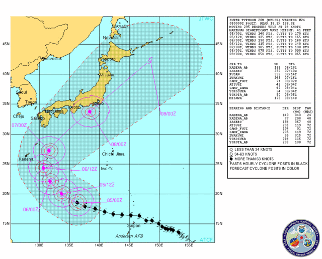
Nothing has changed very much in the forecast. The model consensus is for a recurving, weakening, 105 to 115 knot typhoon passing 200 to 300 miles to your east on Tuesday, so you will be on the weaker side with northerly winds. It's still too early to tell what will really happen, but apparently the JTWC and JMA are still confident in that forecast right now. Unless MELOR gets further west than the models are progging, they just don't expect severe typhoon conditions in your area. At least that's what it looks like from what they're doing.

Personal Forecast Disclaimer:
The posts in this forum are NOT official forecast and should not be used as such. They are just the opinion of the poster and may or may not be backed by sound meteorological data. They are NOT endorsed by any professional institution or storm2k.org. For official information, please refer to the NHC and NWS products.
0 likes   

User avatar
StormingB81
S2K Supporter
S2K Supporter
Posts: 5676
Age: 42
Joined: Thu Aug 27, 2009 1:45 am
Location: Rockledge, Florida

#346 Postby StormingB81 » Sun Oct 04, 2009 9:54 pm

Nothing has changed much? Well only about 150 NM. Yesterday they said closest point was 311 Today they say 165. WHat will the 1700 one say? lol like I said we will just have to wait and see because seems this storm is doing its own thing.
0 likes   

ozonepete
Professional-Met
Professional-Met
Posts: 4743
Joined: Mon Sep 07, 2009 3:23 pm
Location: From Ozone Park, NYC / Now in Brooklyn, NY

Re: WPAC : TYPHOON MELOR (20W)

#347 Postby ozonepete » Sun Oct 04, 2009 10:01 pm

It's interesting how the models and the JTWC interpretations have been very consistent on this storm. The forecast has consistently pointed to the Tokyo area as the only place where the eye will come close. I also posted earlier that they would probably bring the winds down over time, and they have. The latest forecast not only has dropped the winds as it passes Tokyo to 75 knots with gusts to 90 knots, but they've also slowed the arrival time to 08/00Z from 07/12Z. Regardless, they're still forecasting a full typhoon for Tokyo on Wednesday/Thursday. Should be quite interesting.

Image

Personal Forecast Disclaimer:
The posts in this forum are NOT official forecast and should not be used as such. They are just the opinion of the poster and may or may not be backed by sound meteorological data. They are NOT endorsed by any professional institution or storm2k.org. For official information, please refer to the NHC and NWS products.
0 likes   

ozonepete
Professional-Met
Professional-Met
Posts: 4743
Joined: Mon Sep 07, 2009 3:23 pm
Location: From Ozone Park, NYC / Now in Brooklyn, NY

Re:

#348 Postby ozonepete » Sun Oct 04, 2009 10:04 pm

StormingB81 wrote:Nothing has changed much? Well only about 150 NM. Yesterday they said closest point was 311 Today they say 165. WHat will the 1700 one say? lol like I said we will just have to wait and see because seems this storm is doing its own thing.


Yeah, LOL, that's totally a good point if you're sitting where you are! Guess I was being a little too "Poindexter" there. I still hope they're right, though, and you make out OK.
0 likes   

User avatar
StormingB81
S2K Supporter
S2K Supporter
Posts: 5676
Age: 42
Joined: Thu Aug 27, 2009 1:45 am
Location: Rockledge, Florida

#349 Postby StormingB81 » Sun Oct 04, 2009 10:11 pm

Its all good. LOL But 110 Knots (if it where to hit here) is still a pretty good kick if it moved a little more to the west and hits us. Thats like 126 mph sustained.
0 likes   

ozonepete
Professional-Met
Professional-Met
Posts: 4743
Joined: Mon Sep 07, 2009 3:23 pm
Location: From Ozone Park, NYC / Now in Brooklyn, NY

Re:

#350 Postby ozonepete » Sun Oct 04, 2009 10:19 pm

StormingB81 wrote:Its all good. LOL But 110 Knots (if it where to hit here) is still a pretty good kick if it moved a little more to the west and hits us. Thats like 126 mph sustained.


Absolutely. I'm still jealous. Be safe, enjoy whatever you get, and I'm sure you know that where you are they get a LOT of big tropical cyclones. Inevitably you'll see plenty of them over there, regardless of what you get from this one. Just be safe.
0 likes   

User avatar
StormingB81
S2K Supporter
S2K Supporter
Posts: 5676
Age: 42
Joined: Thu Aug 27, 2009 1:45 am
Location: Rockledge, Florida

#351 Postby StormingB81 » Sun Oct 04, 2009 10:22 pm

Okinawa hasn't had a Typhoon is over 2 years believe it or not. Sept 07 was the last one.
0 likes   

User avatar
HURAKAN
Professional-Met
Professional-Met
Posts: 46086
Age: 37
Joined: Thu May 20, 2004 4:34 pm
Location: Key West, FL
Contact:

#352 Postby HURAKAN » Sun Oct 04, 2009 10:30 pm

ZCZC 452
WTPQ22 RJTD 050000
RSMC TROPICAL CYCLONE ADVISORY
NAME TY 0918 MELOR (0918)
ANALYSIS
PSTN 050000UTC 18.5N 136.3E GOOD
MOVE WNW 14KT
PRES 910HPA
MXWD 110KT
GUST 155KT
50KT 100NM
30KT 300NM NORTHEAST 210NM SOUTHWEST
FORECAST
24HF 060000UTC 22.2N 131.5E 75NM 70%
MOVE NW 15KT
PRES 910HPA
MXWD 110KT
GUST 155KT
48HF 070000UTC 26.4N 131.2E 180NM 70%
MOVE N 11KT
PRES 920HPA
MXWD 100KT
GUST 140KT
72HF 080000UTC 32.3N 135.8E 250NM 70%
MOVE NNE 18KT
PRES 940HPA
MXWD 085KT
GUST 120KT =
NNNN


0 likes   

User avatar
StormingB81
S2K Supporter
S2K Supporter
Posts: 5676
Age: 42
Joined: Thu Aug 27, 2009 1:45 am
Location: Rockledge, Florida

#353 Postby StormingB81 » Sun Oct 04, 2009 10:40 pm

It looks like it is starting that turn so guess it just got a late start and it will miss us. Then I could be wrong..lol
0 likes   

User avatar
StormingB81
S2K Supporter
S2K Supporter
Posts: 5676
Age: 42
Joined: Thu Aug 27, 2009 1:45 am
Location: Rockledge, Florida

#354 Postby StormingB81 » Sun Oct 04, 2009 10:47 pm

As of 1300 Okinawa is now at TCCOR 3.
0 likes   

User avatar
HURAKAN
Professional-Met
Professional-Met
Posts: 46086
Age: 37
Joined: Thu May 20, 2004 4:34 pm
Location: Key West, FL
Contact:

Re: WPAC : TYPHOON MELOR (20W)

#355 Postby HURAKAN » Sun Oct 04, 2009 10:57 pm

Image

Image

An absolute beauty, WOW.
0 likes   

User avatar
Macrocane
Category 5
Category 5
Posts: 4218
Age: 35
Joined: Sun May 24, 2009 5:35 pm
Location: El Salvador

Re: WPAC : TYPHOON MELOR (20W)

#356 Postby Macrocane » Sun Oct 04, 2009 10:59 pm

Amazing! but, an ERC may have begun?
0 likes   

User avatar
HURAKAN
Professional-Met
Professional-Met
Posts: 46086
Age: 37
Joined: Thu May 20, 2004 4:34 pm
Location: Key West, FL
Contact:

#357 Postby HURAKAN » Sun Oct 04, 2009 11:03 pm

Image

Image

A little comparison!!! (There's no comparison)
0 likes   

User avatar
HURAKAN
Professional-Met
Professional-Met
Posts: 46086
Age: 37
Joined: Thu May 20, 2004 4:34 pm
Location: Key West, FL
Contact:

#358 Postby HURAKAN » Sun Oct 04, 2009 11:05 pm

05/0230 UTC 18.8N 135.5E T7.0/7.0 MELOR -- West Pacific

No surprises here
0 likes   

pojo
Military Member
Military Member
Posts: 8016
Age: 42
Joined: Thu Feb 06, 2003 9:16 pm
Location: Houston

Re: WPAC : TYPHOON MELOR (20W)

#359 Postby pojo » Sun Oct 04, 2009 11:55 pm

Image

This is a classic case of Stadium effect with Undercast. Beautiful Storm!
0 likes   

User avatar
Infdidoll
Category 2
Category 2
Posts: 667
Age: 46
Joined: Thu Oct 01, 2009 8:39 pm
Location: Temecula, CA

Re:

#360 Postby Infdidoll » Mon Oct 05, 2009 12:26 am

StormingB81 wrote:As of 1300 Okinawa is now at TCCOR 3.


I just heard that on our one lousy radio station. Not surprisingly, still not on Kadena's website! Whomever updates it must be on vacation. I just took some video of the dragonfly swarm outside. To top it all off, heard my husband may be going back to the States for a few days, leaving me here with a 4 & 3 year-old. This is going to be fun.
0 likes   


Return to “2009”

Who is online

Users browsing this forum: No registered users and 10 guests