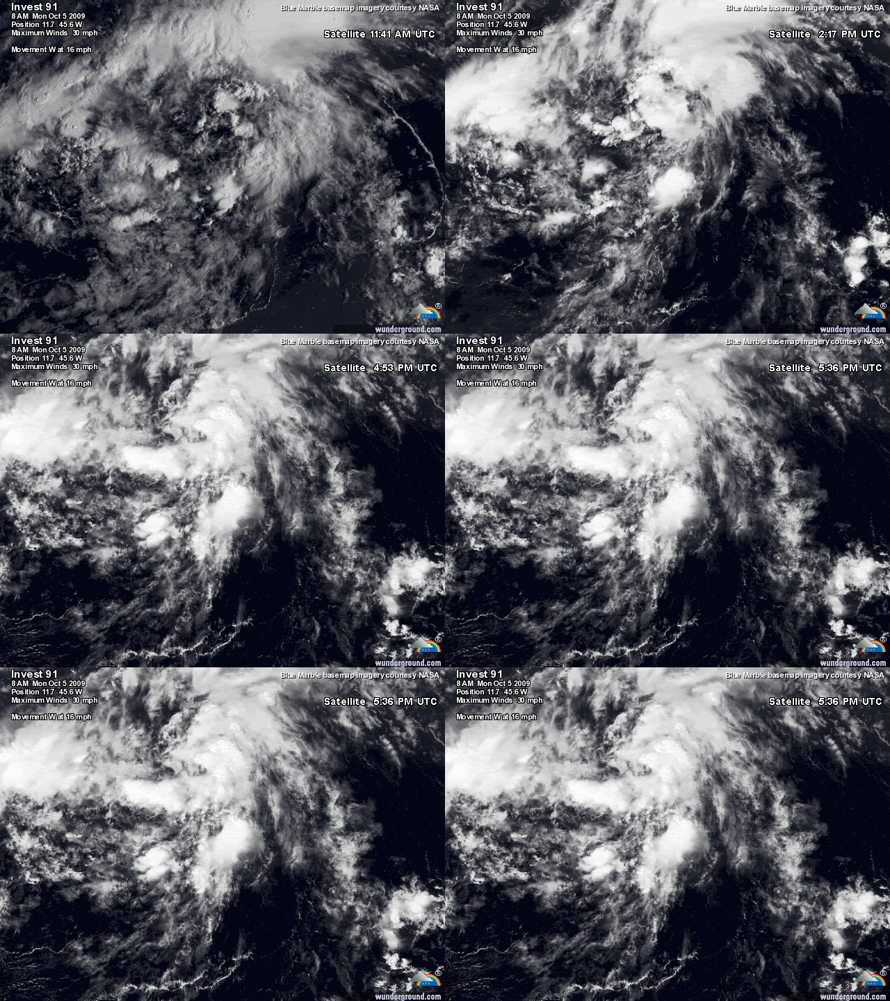
ATL: TROPICAL DEPRESSION HENRI (10L)

Moderator: S2k Moderators

Message
Author
User avatar
gatorcane
S2K Supporter
S2K Supporter
Posts: 23499
Age: 46
Joined: Sun Mar 13, 2005 3:54 pm
Location: Boca Raton, FL

Re: Re:

#61 Postby gatorcane » Mon Oct 05, 2009 11:22 am

wxman57 wrote:
hurricanetrack wrote:FWIW, the GFS seems to NOT develop this one but some other conglomeration of mess as this system scoots on off to the WNW. Has anyone else noticed this over the last couple of days? 91L seems to just go away as some other system takes over farther south and east. But even it does very little in the long run. I suppose we'll find out one way or another.


I noticed the 00Z GFS took the low-level vorticity into Honduras.


Right but if it were a hurricane as it enters the Western Caribbean, likely to feel the trough to the north and get pulled north.

That trough that is supposed to dive down into the Eastern CONUS early next week is quite strong when I look at the ECMWF runs.

The fact that global models don't develop this thing is good news, likely won't develop if they all agree on no development. So I'm not that concerned, yet. Clearly the global models are seeing something that would kill development once in the Caribbean.
0 likes   

User avatar
gatorcane
S2K Supporter
S2K Supporter
Posts: 23499
Age: 46
Joined: Sun Mar 13, 2005 3:54 pm
Location: Boca Raton, FL

Re: ATL : INVEST 91L

#62 Postby gatorcane » Mon Oct 05, 2009 11:30 am

Blown_away wrote::uarrow: Looking good rate now!


Yes its look very good right now...makes you wonder if we'll have code orange or even red at 2pm TWO. I'm thinking we'll see code orange.

What does the quickstat show, anything at the surface yet?
0 likes   

User avatar
gatorcane
S2K Supporter
S2K Supporter
Posts: 23499
Age: 46
Joined: Sun Mar 13, 2005 3:54 pm
Location: Boca Raton, FL

#63 Postby gatorcane » Mon Oct 05, 2009 11:32 am

12Z GFS nearly loses it in Western Caribbean by 168 hours, but note the big cold front to the north entering the GOM.

Image

Steering at H5 layer showing the Bermuda High weakening and moving east as the cold front enters the GOM:
Image
0 likes   

User avatar
Evil Jeremy
S2K Supporter
S2K Supporter
Posts: 5459
Age: 31
Joined: Mon Apr 10, 2006 2:10 pm
Location: Los Angeles, CA

Re: ATL : INVEST 91L

#64 Postby Evil Jeremy » Mon Oct 05, 2009 11:43 am

I don't think we will see a code orange on this thing for a while. It still has a lot of organization to accomplish. Yes, it appears that convection is forming around a center, but persistence is the key. If organization continues into the night, maybe an Orange at 8 PM, but I think it will stay Yellow at 2. Many systems like this one have fallen apart this year, we need to see if this one can stay alive for now.
0 likes   
Frances 04 / Jeanne 04 / Katrina 05 / Wilma 05 / Fay 08 / Debby 12 / Andrea 13 / Colin 16 / Hermine 16 / Matthew 16 / Irma 17

Derek Ortt

#65 Postby Derek Ortt » Mon Oct 05, 2009 11:45 am

nothing is organizing. Chances of development appear slim and none and slim may have just found the door
0 likes   

User avatar
Ptarmigan
Category 5
Category 5
Posts: 5273
Joined: Wed Aug 16, 2006 9:06 pm

Re: ATL : INVEST 91L

#66 Postby Ptarmigan » Mon Oct 05, 2009 12:01 pm

If 91L form, it would be Henri.
0 likes   

User avatar
HURAKAN
Professional-Met
Professional-Met
Posts: 46086
Age: 37
Joined: Thu May 20, 2004 4:34 pm
Location: Key West, FL
Contact:

#67 Postby HURAKAN » Mon Oct 05, 2009 12:30 pm

Buoy 41041 http://www.ndbc.noaa.gov/station_page.php?station=41041

Wind Direction (WDIR): SE ( 140 deg true )
Wind Speed Wind Speed (WSPD): 27.2 kts
Wind Gust Wind Gust (GST): 31.1 kts
Atmospheric Pressure Atmospheric Pressure (PRES): 29.82 in
Pressure Tendency Pressure Tendency (PTDY): -0.08 in ( Falling )
Air Temperature Air Temperature (ATMP): 78.4 °F
Water Temperature Water Temperature (WTMP): 82.8 °F
0 likes   

User avatar
cycloneye
Admin
Admin
Posts: 139327
Age: 67
Joined: Thu Oct 10, 2002 10:54 am
Location: San Juan, Puerto Rico

Re: ATL : INVEST 91L

#68 Postby cycloneye » Mon Oct 05, 2009 12:34 pm

Code Orange

ABNT20 KNHC 051734
TWOAT
TROPICAL WEATHER OUTLOOK
NWS TPC/NATIONAL HURRICANE CENTER MIAMI FL
200 PM EDT MON OCT 5 2009

FOR THE NORTH ATLANTIC...CARIBBEAN SEA AND THE GULF OF MEXICO...

THE NATIONAL HURRICANE CENTER IS ISSUING ADVISORIES ON TROPICAL
STORM GRACE...MOVING RAPIDLY NORTHEASTWARD OVER THE NORTHEASTERN
ATLANTIC.

A TROPICAL WAVE LOCATED ABOUT 950 MILES EAST OF THE WINDWARD
ISLANDS IS MOVING WEST-NORTHWESTWARD AT AROUND 15 MPH. SATELLITE
IMAGERY INDICATES THAT THIS SYSTEM IS GRADUALLY BECOMING BETTER
ORGANIZED...AND SOME ADDITIONAL DEVELOPMENT IS POSSIBLE BEFORE
UPPER-LEVEL WINDS BECOME LESS FAVORABLE IN A COUPLE OF DAYS. THERE
IS A MEDIUM CHANCE...30 TO 50 PERCENT...OF THIS SYSTEM BECOMING A
TROPICAL CYCLONE DURING THE NEXT 48 HOURS.

ELSEWHERE...TROPICAL CYCLONE FORMATION IS NOT EXPECTED DURING THE
NEXT 48 HOURS.

PUBLIC ADVISORIES ON GRACE ARE ISSUED UNDER WMO HEADER WTNT34 KNHC
AND UNDER AWIPS HEADER MIATCPAT4. FORECAST/ADVISORIES ON GRACE ARE
ISSUED UNDER WMO HEADER WTNT24 KNHC AND UNDER AWIPS HEADER
MIATCMAT4.

$$
FORECASTER BRENNAN

Image
0 likes   
Visit the Caribbean-Central America Weather Thread where you can find at first post web cams,radars
and observations from Caribbean basin members Click Here

Aric Dunn
Category 5
Category 5
Posts: 21228
Age: 41
Joined: Sun Sep 19, 2004 9:58 pm
Location: Ready for the Chase.
Contact:

#69 Postby Aric Dunn » Mon Oct 05, 2009 12:35 pm

Pretty evident from satellite we have a circ starting to take shape pretty quickly today. it has a small window to develop under decent upper environment over the next 2 days or so. the forecast is also pretty straight forward as a massive ridge will slide of the east coast with it though there will be a large area of strong upper winds which should kill it unless it stays way south as the cmc says it might. but even then chance are low for it to maintain. i expect code orange at 2 or 8pm tonight
0 likes   

Aric Dunn
Category 5
Category 5
Posts: 21228
Age: 41
Joined: Sun Sep 19, 2004 9:58 pm
Location: Ready for the Chase.
Contact:

Re:

#70 Postby Aric Dunn » Mon Oct 05, 2009 12:36 pm

Aric Dunn wrote:Pretty evident from satellite we have a circ starting to take shape pretty quickly today. it has a small window to develop under decent upper environment over the next 2 days or so. the forecast is also pretty straight forward as a massive ridge will slide of the east coast with it though there will be a large area of strong upper winds which should kill it unless it stays way south as the cmc says it might. but even then chance are low for it to maintain. i expect code orange at 2 or 8pm tonight


hehe well ok then .. lol Code orange :P :uarrow:
0 likes   

User avatar
Blown Away
S2K Supporter
S2K Supporter
Posts: 9867
Joined: Wed May 26, 2004 6:17 am

Re: ATL : INVEST 91L update=TWO 2 PM EDT=Code Orange

#71 Postby Blown Away » Mon Oct 05, 2009 12:41 pm

Probably at the mid levels, but it is obvious the convection is starting to consolidate and there is a nice cyclonic rotation. Will it last, I don't know, but this system is getting better organized. Local Met's talking about this wave.
Last edited by Blown Away on Mon Oct 05, 2009 12:42 pm, edited 1 time in total.
0 likes   
Hurricane Eye Experience: David 79, Irene 99, Frances 04, Jeanne 04, Wilma 05... EYE COMING MY WAY IN 2024…
Hurricane Brush Experience: Andrew 92, Erin 95, Floyd 99, Matthew 16, Irma 17, Ian 22, Nicole 22…

User avatar
HURAKAN
Professional-Met
Professional-Met
Posts: 46086
Age: 37
Joined: Thu May 20, 2004 4:34 pm
Location: Key West, FL
Contact:

#72 Postby HURAKAN » Mon Oct 05, 2009 12:41 pm

Image

Loop
0 likes   

Aric Dunn
Category 5
Category 5
Posts: 21228
Age: 41
Joined: Sun Sep 19, 2004 9:58 pm
Location: Ready for the Chase.
Contact:

Re: ATL : INVEST 91L update=TWO 2 PM EDT=Code Orange

#73 Postby Aric Dunn » Mon Oct 05, 2009 12:42 pm

Would like to point out the buoy near by ..pressure are falling pretty quickly today and winds are up quite a bit .. once a closed circ is determined A td would be inline or storm ..

this buoy is nearly under the developing center or just east of the center
Image
0 likes   

User avatar
Gustywind
Category 5
Category 5
Posts: 12334
Joined: Mon Sep 03, 2007 7:29 am
Location: Baie-Mahault, GUADELOUPE

#74 Postby Gustywind » Mon Oct 05, 2009 12:54 pm

000
AXNT20 KNHC 051746
TWDAT

TROPICAL WEATHER DISCUSSION
NWS TPC/NATIONAL HURRICANE CENTER MIAMI FL
205 PM EDT MON OCT 05 2009

TROPICAL WEATHER DISCUSSION FOR NORTH AMERICA...CENTRAL
AMERICA...GULF OF MEXICO...CARIBBEAN SEA...NORTHERN SECTIONS
OF SOUTH AMERICA...AND ATLANTIC OCEAN TO THE AFRICAN COAST
FROM THE EQUATOR TO 32N. THE FOLLOWING INFORMATION IS BASED
ON SATELLITE IMAGERY...METEOROLOGICAL ANALYSIS...WEATHER
OBSERVATIONS...AND RADAR.

BASED ON 1200 UTC SURFACE ANALYSIS AND SATELLITE IMAGERY THROUGH
1715 UTC.

...TROPICAL WAVES...

TROPICAL WAVE IS ALONG 45W S OF 17N MOVING NW 15 KT. LOW
AMPLITUDE WAVE MOSTLY EMBEDDED WITHIN THE ITCZ AND EMBEDDED
WITHIN A DEEP LAYER MOISTURE MAXIMUM PEAK AS OBSERVED IN TOTAL
PRECIPITABLE WATER IMAGERY. BROAD MID LEVEL CYCLONIC TURNING CAN
BE OBSERVED IN THE VISIBLE SATELLITE IMAGERY. ASSOCIATED
CONVECTION IS BEING ENHANCED BY A BROAD E/W UPPER RIDGE THAT IS
ANCHORED TO THE E OF THE WAVE AXIS. LARGE CLUSTERS OF SCATTERED
MODERATE/ISOLATED STRONG CONVECTION IS FROM 10N-16N BETWEEN
45W-49W.


$$
WALLACE
0 likes   

User avatar
cycloneye
Admin
Admin
Posts: 139327
Age: 67
Joined: Thu Oct 10, 2002 10:54 am
Location: San Juan, Puerto Rico

Re: ATL: Invest 91L - Models

#75 Postby cycloneye » Mon Oct 05, 2009 1:03 pm

The 12z CMC has a weak system moving over Puerto Rico and ending in the northern Cuban coast.

http://moe.met.fsu.edu/cgi-bin/cmctc2.c ... =Animation
0 likes   
Visit the Caribbean-Central America Weather Thread where you can find at first post web cams,radars
and observations from Caribbean basin members Click Here

Cuber
S2K Supporter
S2K Supporter
Posts: 63
Joined: Sun Oct 23, 2005 4:04 pm
Location: Plm Bch Grdns FL

Re: ATL : INVEST 91L update=TWO 2 PM EDT=Code Orange

#76 Postby Cuber » Mon Oct 05, 2009 1:18 pm

Hey Gusty .... time to find those hip boots/waders etc and waterproof that keyboard/monitor/cpu ... it appears that it's gonna get wet and windy for you soon ... looking forward to your "live in the eye" updates
0 likes   

User avatar
HURAKAN
Professional-Met
Professional-Met
Posts: 46086
Age: 37
Joined: Thu May 20, 2004 4:34 pm
Location: Key West, FL
Contact:

#77 Postby HURAKAN » Mon Oct 05, 2009 1:20 pm

Loop: http://rammb.cira.colostate.edu/ramsdis ... _floater_2

This system has impressed me today with its continued development. Looking quite good.

Looking forward to D-MAX
0 likes   

User avatar
cycloneye
Admin
Admin
Posts: 139327
Age: 67
Joined: Thu Oct 10, 2002 10:54 am
Location: San Juan, Puerto Rico

Re: ATL : INVEST 91L

#78 Postby cycloneye » Mon Oct 05, 2009 1:33 pm

18 UTC Best Track

AL, 91, 2009100518, , BEST, 0, 137N, 465W, 30, 1007, DB

ftp://ftp.tpc.ncep.noaa.gov/atcf/tcweb/ ... 009.invest
0 likes   
Visit the Caribbean-Central America Weather Thread where you can find at first post web cams,radars
and observations from Caribbean basin members Click Here

User avatar
Gustywind
Category 5
Category 5
Posts: 12334
Joined: Mon Sep 03, 2007 7:29 am
Location: Baie-Mahault, GUADELOUPE

Re: ATL : INVEST 91L update=TWO 2 PM EDT=Code Orange

#79 Postby Gustywind » Mon Oct 05, 2009 1:35 pm

Cuber wrote:Hey Gusty .... time to find those hip boots/waders etc and waterproof that keyboard/monitor/cpu ... it appears that it's gonna get wet and windy for you soon ... looking forward to your "live in the eye" updates

Hi Cuber tkanks for this advice/wink :). We continue to observe what could happpen with 91L, let's wait and see...but given our ProMets of Meteo-France Guadeloupe, a perturbed weather should bring numerous showers and tstorms Thursday. As usual we're far away from the reality, anyway we have to wait and see.
Have a nice day :)
0 likes   

User avatar
cycloneye
Admin
Admin
Posts: 139327
Age: 67
Joined: Thu Oct 10, 2002 10:54 am
Location: San Juan, Puerto Rico

Re: ATL: Invest 91L - Models

#80 Postby cycloneye » Mon Oct 05, 2009 1:35 pm

18 UTC Bam Models

WHXX01 KWBC 051830
CHGHUR
TROPICAL CYCLONE GUIDANCE MESSAGE
NWS TPC/NATIONAL HURRICANE CENTER MIAMI FL
1830 UTC MON OCT 5 2009

DISCLAIMER...NUMERICAL MODELS ARE SUBJECT TO LARGE ERRORS.
PLEASE REFER TO NHC OFFICIAL FORECASTS FOR TROPICAL CYCLONE
AND SUBTROPICAL CYCLONE INFORMATION.

ATLANTIC OBJECTIVE AIDS FOR

DISTURBANCE INVEST (AL912009) 20091005 1800 UTC

...00 HRS... ...12 HRS... ...24 HRS. .. ...36 HRS...
091005 1800 091006 0600 091006 1800 091007 0600

LAT LON LAT LON LAT LON LAT LON
BAMS 13.7N 46.5W 15.7N 50.1W 17.9N 53.4W 19.6N 56.1W
BAMD 13.7N 46.5W 15.1N 49.0W 16.7N 51.3W 18.4N 53.1W
BAMM 13.7N 46.5W 15.0N 49.4W 16.6N 52.1W 18.0N 54.3W
LBAR 13.7N 46.5W 15.2N 48.7W 17.2N 50.8W 18.9N 52.6W
SHIP 30KTS 35KTS 39KTS 44KTS
DSHP 30KTS 35KTS 39KTS 44KTS

...48 HRS... ...72 HRS... ...96 HRS. .. ..120 HRS...
091007 1800 091008 1800 091009 1800 091010 1800

LAT LON LAT LON LAT LON LAT LON
BAMS 20.9N 58.4W 22.4N 61.6W 22.0N 63.3W 20.3N 67.0W
BAMD 20.0N 54.4W 22.0N 56.2W 20.8N 56.3W 17.8N 59.6W
BAMM 19.1N 56.1W 20.1N 59.7W 19.4N 63.6W 17.7N 69.8W
LBAR 20.8N 53.3W 23.7N 51.8W 26.0N 45.4W 29.2N 37.2W
SHIP 47KTS 46KTS 52KTS 62KTS
DSHP 47KTS 46KTS 52KTS 59KTS

...INITIAL CONDITIONS...
LATCUR = 13.7N LONCUR = 46.5W DIRCUR = 305DEG SPDCUR = 14KT
LATM12 = 11.8N LONM12 = 44.3W DIRM12 = 299DEG SPDM12 = 15KT
LATM24 = 10.9N LONM24 = 41.3W
WNDCUR = 30KT RMAXWD = 30NM WNDM12 = 25KT
CENPRS = 1007MB OUTPRS = 1012MB OUTRAD = 150NM SDEPTH = M
RD34NE = 0NM RD34SE = 0NM RD34SW = 0NM RD34NW = 0NM

Image
0 likes   
Visit the Caribbean-Central America Weather Thread where you can find at first post web cams,radars
and observations from Caribbean basin members Click Here


Return to “2009”

Who is online

Users browsing this forum: No registered users and 1 guest