CPAC: TROPICAL DEPRESSION FELICIA (08E)
Moderator: S2k Moderators

Re: EPAC: HURRICANE FELICIA (08E)
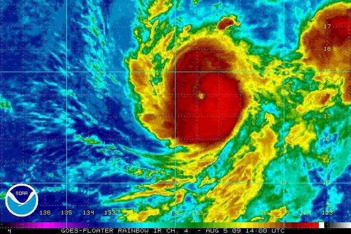
IR looking good, Microwave looking bad. I agree that 85 kt could be a little generous but 55 kt is too low. It seems that some dry air is trying to wrap in the center, but that's the only factor that I see against its intensification, Enrique is dying so Felicia can continue with its trend I'm hoping for a major hurricane tomorrow.
0 likes
-
HurricaneJoe22
- Category 1

- Posts: 456
- Joined: Wed Sep 08, 2004 12:45 am
- Location: Temple, Texas
Re: EPAC: HURRICANE FELICIA (08E)
At least the Pacific is keeping us entertained while we wait for the Atlantic to come alive.
0 likes
-
Derek Ortt
-
Derek Ortt
Re: EPAC: HURRICANE FELICIA (08E)
Macrocane wrote:IR looking good, Microwave looking bad. I agree that 85 kt could be a little generous but 55 kt is too low. It seems that some dry air is trying to wrap in the center, but that's the only factor that I see against its intensification, Enrique is dying so Felicia can continue with its trend I'm hoping for a major hurricane tomorrow.
I kept it at 65KT on nwhhc tonight
0 likes

-
wxmann_91

- Category 5

- Posts: 8013
- Age: 33
- Joined: Fri Jul 15, 2005 2:49 pm
- Location: Southern California
- Contact:
Re: Re:
what the heck at the latest NHC intensity estimate. I know satellite estimates say whatever knots, but microwave data simply cannot be ignored.
I-wall, TMI, SSMI, and other microwave data can be found on NRL. Available to the entire public.
I-wall wrote:Derek Ortt wrote:The entire northern eyewall has been eroded based upon the latest TMI imagery. If anything, Felicia has weakened.
65KT at the most right now
No fair. You have special tools at your dispense. Kidding.....thanks for the info Derek. That's interesting to know. I thought for certain she was still picking up steam.
I-wall, TMI, SSMI, and other microwave data can be found on NRL. Available to the entire public.
0 likes
-
brunota2003

- S2K Supporter

- Posts: 9476
- Age: 33
- Joined: Sat Jul 30, 2005 9:56 pm
- Location: Stanton, KY...formerly Havelock, NC
- Contact:


Re: EPAC: HURRICANE FELICIA (08E)
Is there an irony fairy for emergency planning? Or at least some weird timing between storm and state government budget shortfalls? Right now, there's no guarantee the storm will miss the Big Island:
http://www.honoluluadvertiser.com/apps/ ... ckcomments
http://www.honoluluadvertiser.com/apps/ ... ckcomments
0 likes
-
wxmann_91
- Category 5
- Posts: 8013
- Age: 33
- Joined: Fri Jul 15, 2005 2:49 pm
- Location: Southern California
- Contact:
The lack of precipitation despite such strong convection in the eastern semicircle also says a lot about the amount of dry air being entrained into this system. The stratocumulus deck and associated dry air to the west can be seen having an effect in the Microwave. I wonder if Felicia can mix that out. If I recall correctly, Carlos had a similar look on satellite before he crapped out and sunk into the ITCZ (the first time) (not saying Felicia will do the same thing).
0 likes
-
cycloneye

- Admin

- Posts: 139537
- Age: 67
- Joined: Thu Oct 10, 2002 10:54 am
- Location: San Juan, Puerto Rico
Re: EPAC: HURRICANE FELICIA (08E)
ZCZC MIATCDEP3 ALL
TTAA00 KNHC DDHHMM
HURRICANE FELICIA DISCUSSION NUMBER 7
NWS TPC/NATIONAL HURRICANE CENTER MIAMI FL EP082009
200 AM PDT WED AUG 05 2009
SATELLITE INTENSITY ESTIMATES AT 0600 UTC FROM TAFB AND SAB WERE
T4.5 AND T4.0...RESPECTIVELY...BUT SINCE THAT TIME THE SATELLITE
PRESENTATION HAS CONTINUED TO IMPROVE. THE EYE HAS NOW PERSISTED
FOR SEVERAL HOURS AND CONTINUES TO WARM WITH THE DEEPEST CONVECTION
LOCATED IN THE EASTERN AND SOUTHEASTERN SEMICIRCLES. AN ANALYSIS
WOULD NOW YIELD A AVERAGE DATA T-NUMBER OF 5.0 ON THE DVORAK
SCALE...AND THE INITIAL INTENSITY IS BEING RAISED TO 90 KT.
NOW THAT FELICIA IS A DEEPER SYSTEM...IT IS BEING PULLED A LITTLE
MORE TO THE NORTH BY A LARGE MID- TO UPPER-LEVEL TROUGH LOCATED OFF
THE U.S. WEST COAST. THE INITIAL MOTION IS 300/10...AND LITTLE
CHANGE TO THIS HEADING IS EXPECTED OVER THE NEXT 48 HOURS WHILE THE
MID-LATITUDE TROUGH REMAINS NEARLY STATIONARY. BY DAYS 4 AND 5...
TWO FACTORS WILL CAUSE FELICIA TO TURN TO THE WEST. FIRST...THE
TROUGH WILL MOVE EASTWARD OVER WESTERN NORTH AMERICA AND WILL BE
REPLACED BY A MID-LEVEL HIGH CURRENTLY LOCATED NORTH OF HAWAII.
SECOND...FELICIA WILL LIKELY BE WEAKENING BY THAT TIME AND WILL BE
INFLUENCED MORE STRONGLY BY THE LOWER-LEVEL TRADE WIND FLOW. THERE
HAS BEEN A NOTICEABLE NORTHWARD SHIFT IN THE TIGHTLY-CLUSTERED
GUIDANCE ENVELOPE FOR THIS PACKAGE...AND THE OFFICIAL FORECAST IS
SHIFTED NORTHWARD TOWARDS THE MODEL CONSENSUS.
THE ENVIRONMENT AROUND FELICIA REMAINS CONDUCIVE FOR FURTHER
STRENGTHENING. THE MID-LEVEL CUT-OFF LOW NEAR CALIFORNIA IS
INDUCING DIFFLUENCE ALOFT TO THE NORTH OF FELICIA...AND IT APPEARS
THAT AN OUTFLOW JET MAY BE FORMING. VERTICAL SHEAR IS EXPECTED TO
REMAIN LIGHT OVER THE NEXT FIVE DAYS...AND OCEANIC HEAT CONTENT
SHOULD REMAIN SUFFICIENT FOR AT LEAST THE NEXT 36 HOURS. THE
NORTHWARD SHIFT IN THE TRACK FORECAST PUTS FELICIA OVER 24-25
DEGREES CELSIUS WATER AFTER 48 HOURS...AND THE NEW OFFICIAL
INTENSITY FORECAST ACCOUNTS FOR THIS BY SHOWING FASTER WEAKENING
THAN WAS INDICATED IN THE PREVIOUS FORECAST. IF FELICIA STAYS A
LITTLE FARTHER SOUTH...IT MIGHT BE ABLE TO MAINTAIN ITS INTENSITY
FOR A LONGER PERIOD OF TIME.
FORECAST POSITIONS AND MAX WINDS
INITIAL 05/0900Z 13.4N 128.2W 90 KT
12HR VT 05/1800Z 14.1N 129.5W 100 KT
24HR VT 06/0600Z 15.1N 131.2W 105 KT
36HR VT 06/1800Z 16.1N 132.8W 100 KT
48HR VT 07/0600Z 17.1N 134.6W 90 KT
72HR VT 08/0600Z 18.5N 139.0W 75 KT
96HR VT 09/0600Z 19.0N 144.5W 65 KT
120HR VT 10/0600Z 19.0N 150.0W 50 KT
$$
FORECASTER BERG
0 likes
-
CrazyC83
- Professional-Met

- Posts: 33397
- Joined: Tue Mar 07, 2006 11:57 pm
- Location: Deep South, for the first time!
Current Intensity Analysis
UW - CIMSS
ADVANCED DVORAK TECHNIQUE
ADT-Version 7.2.3
Tropical Cyclone Intensity Algorithm
----- Current Analysis -----
Date : 05 AUG 2009 Time : 110000 UTC
Lat : 13:43:53 N Lon : 128:13:07 W
CI# /Pressure/ Vmax
5.1 / 969.3mb/ 92.4kt
Final T# Adj T# Raw T#
(3hr avg)
5.1 5.9 6.5
Latitude bias adjustment to MSLP : +1.3mb
Estimated radius of max. wind based on IR :N/A km
Center Temp : -31.5C Cloud Region Temp : -73.4C
Scene Type : EYE
Positioning Method : SPIRAL ANALYSIS
Ocean Basin : EAST PACIFIC
Dvorak CI > MSLP Conversion Used : ATLANTIC
Tno/CI Rules : Constraint Limits : 2.2T/6hr
Weakening Flag : OFF
Rapid Dissipation Flag : OFF
0 likes


-
cycloneye
- Admin
- Posts: 139537
- Age: 67
- Joined: Thu Oct 10, 2002 10:54 am
- Location: San Juan, Puerto Rico
Re: EPAC: HURRICANE FELICIA (08E)
12 UTC best track increases winds to 100 kts.
EP, 08, 2009080512, , BEST, 0, 137N, 1283W, 100, 960, HU
EP, 08, 2009080512, , BEST, 0, 137N, 1283W, 100, 960, HU
0 likes
-
cyclonic chronic
http://www.ssd.noaa.gov/goes/flt/t7/loop-avn.html
outter bands of enrique being pulled into felicia's circulation. also convection has completely wrapped around the eye. starting to look close to a 100kt storm.
outter bands of enrique being pulled into felicia's circulation. also convection has completely wrapped around the eye. starting to look close to a 100kt storm.
0 likes

Re: EPAC: HURRICANE FELICIA (08E)
It's exciting to see such an event, a hurricane eating another system, great 
0 likes
-
srainhoutx

- S2K Supporter
- Posts: 6919
- Age: 66
- Joined: Sun Jan 14, 2007 11:34 am
- Location: Haywood County, NC
- Contact:
Re: EPAC: HURRICANE FELICIA (08E)
HURRICANE FELICIA ADVISORY NUMBER 8
NWS TPC/NATIONAL HURRICANE CENTER MIAMI FL EP082009
ISSUED BY THE HYDROMETEOROLOGICAL PREDICTION CENTER CAMP SPRINGS MD
800 AM PDT WED AUG 05 2009
..FELICIA CONTINUES TO STRENGTHEN...REACHES MAJOR HURRICANE
STATUS...
AT 800 AM PDT...1500 UTC...THE CENTER OF HURRICANE FELICIA WAS
LOCATED NEAR LATITUDE 14.1 NORTH...LONGITUDE 128.7 WEST OR ABOUT
1370 MILES...2210 KM...WEST-SOUTHWEST OF THE SOUTHERN TIP OF BAJA
CALIFORNIA.
FELICIA IS MOVING TOWARD THE NORTHWEST NEAR 12 MPH...19 KM/HR...AND
THIS MOTION IS EXPECTED TO CONTINUE OVER THE NEXT COUPLE OF DAYS.
SATELLITE IMAGERY INDICATES THAT MAXIMUM SUSTAINED WINDS HAVE
INCREASED TO NEAR 115 MPH...185 KM/HR...WITH HIGHER
GUSTS. LITTLE CHANGE IN STRENGTH IS FORECAST DURING THE NEXT 24
HOURS.
HURRICANE FORCE WINDS EXTEND OUTWARD UP TO 35 MILES...55 KM...FROM
THE CENTER...AND TROPICAL STORM FORCE WINDS EXTEND OUTWARD UP TO 120
MILES...195 KM.
ESTIMATED MINIMUM CENTRAL PRESSURE IS 955 MB...28.20 INCHES.
...SUMMARY OF 800 AM PDT INFORMATION...
LOCATION...14.1N 128.7W
MAXIMUM SUSTAINED WINDS...115 MPH
PRESENT MOVEMENT...NORTHWEST OR 310 DEGREES AT 12 MPH
MINIMUM CENTRAL PRESSURE...955 MB
Last edited by srainhoutx on Wed Aug 05, 2009 10:07 am, edited 1 time in total.
0 likes
-
Ed Mahmoud
Re: EPAC: HURRICANE FELICIA (08E)
Macrocane wrote:It's exciting to see such an event, a hurricane eating another system, great
I still cherish the memory of the Iris-Karen interaction in 1995.
Karen held on a long time even as shear from Iris displaced all its storms and Iris was stealing its inflow.
If Felicia does hit Hawai'i, I'm going to wonder if the lower heights to its East from Enrique disrupted the steering just enough to keep it from missing North.
And people are acting depressed just because the Atlantic is deader than an interstate armadillo.
0 likes
Who is online
Users browsing this forum: No registered users and 5 guests