NW Australia: BILLY - Tropical Cyclone: Discussion

Moderator: S2k Moderators

Message
Author
User avatar
HURAKAN
Professional-Met
Professional-Met
Posts: 46086
Age: 37
Joined: Thu May 20, 2004 4:34 pm
Location: Key West, FL
Contact:

NW Australia: BILLY - Tropical Cyclone: Discussion

#1 Postby HURAKAN » Mon Dec 15, 2008 10:17 pm

Australian Government Bureau of Meteorology
Western Australia

TROPICAL CYCLONE OUTLOOK FOR NORTHWESTERN AUSTRALIA
Issued at 2:00pm WDT on Monday the 15th of December 2008
For the area south of LATITUDE 10 SOUTH between LONGITUDES 110 - 125 EAST

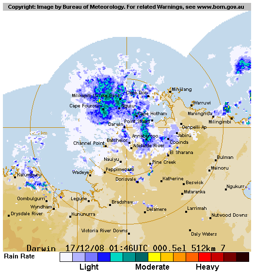
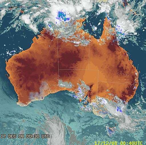
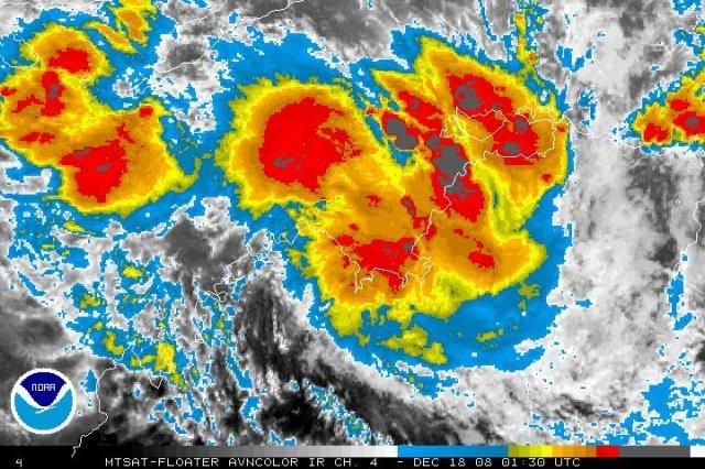
A developing tropical low [1005 hPa] is situated north of the Kimberley in the
Timor Sea. At 11am it was near latitude 10S, longitude 128E, and was almost
stationary. The low is expected to move towards the west or southwest during
the next few days and will be closely monitored.

The likelihood of a tropical cyclone occurring in the outlook area in the next
three days is estimated to be:
Tuesday : Low
Wednesday : Moderate
Thursday : High


** NOTE: Development potential is an estimate of the probability of **
** tropical cyclone development within a 24 hour period. **
** LOW = 10% or less MODERATE = 20-40% HIGH = 50% or more **

Image
0 likes   

User avatar
Chacor
Category 5
Category 5
Posts: 10229
Joined: Mon Oct 02, 2006 10:43 pm
Location: Singapore

#2 Postby Chacor » Tue Dec 16, 2008 12:39 am

TROPICAL CYCLONE OUTLOOK
FOR THE AREA BETWEEN LONGITUDES 125 EAST - 142 EAST
Issued by the BUREAU OF METEOROLOGY, DARWIN
at 2:15 pm CST Tuesday 16 December 2008

A developing TROPICAL LOW 1004 hPa is situated in the TIMOR SEA. At 2pm it was
near latitude 10S, longitude 127E, slow moving. The LOW is expected to move
towards the west or southwest during the next few days, and may move out of the
Northern Region.

The potential for development into a Tropical Cyclone over the next few days is
estimated to be:
Wednesday: low,
Thursday: high,
Friday: high.

NOTE: Development Potential is an estimate of the probability of tropical
cyclone development for each day... Low = 10% or less, Moderate = 20% - 40%,
High = 50% or more.

DARWIN Regional Forecasting Centre.
0 likes   

User avatar
HURAKAN
Professional-Met
Professional-Met
Posts: 46086
Age: 37
Joined: Thu May 20, 2004 4:34 pm
Location: Key West, FL
Contact:

#3 Postby HURAKAN » Tue Dec 16, 2008 7:38 pm

Image

Looking better.
0 likes   

User avatar
HURAKAN
Professional-Met
Professional-Met
Posts: 46086
Age: 37
Joined: Thu May 20, 2004 4:34 pm
Location: Key West, FL
Contact:

#4 Postby HURAKAN » Tue Dec 16, 2008 7:38 pm

THE AREA OF CONVECTION PREVIOUSLY LOCATED NEAR 11.7S 127.4E, IS NOW LOCATED NEAR 12.2S 127.1E APPROXIMATELY 225 NM WEST OF DARWIN, AUSTRALIA. RECENT MICROWAVE IMAGES INDICATE AN IMPROVED LOW LEVEL CIRCULATION CENTER AND WEAK CONVECTIVE BANDING BEGINNING TO DEVELOP. UPPER LEVEL ANALYSIS DEPICTS LOW VERTICAL WIND SHEAR AND FAVORABLE DIFFLUENCE ALOFT. MAXIMUM SUSTAINED SURFACE WINDS ARE ESTIMATED AT 15 TO 20 KNOTS. MINIMUM SEA LEVEL PRESSURE IS ESTIMATED TO BE NEAR 1005 MB. THE POTENTIAL FOR THE DEVELOPMENT OF A SIGNIFICANT TROPICAL CYCLONE WITHIN THE NEXT 24 HOURS REMAINS POOR.
0 likes   

User avatar
HURAKAN
Professional-Met
Professional-Met
Posts: 46086
Age: 37
Joined: Thu May 20, 2004 4:34 pm
Location: Key West, FL
Contact:

#5 Postby HURAKAN » Tue Dec 16, 2008 8:59 pm

Image

Image
0 likes   

User avatar
HURAKAN
Professional-Met
Professional-Met
Posts: 46086
Age: 37
Joined: Thu May 20, 2004 4:34 pm
Location: Key West, FL
Contact:

#6 Postby HURAKAN » Wed Dec 17, 2008 6:10 am

Image

Australian Government Bureau of Meteorology
Northern Territory
Darwin Regional Forecasting Centre

PRIORITY

Media: The Standard Emergency Warning Signal should NOT be used with this
warning.

TROPICAL CYCLONE WATCH

TROPICAL CYCLONE ADVICE NUMBER 1
Issued by the BUREAU OF METEOROLOGY, DARWIN
at 4:00 pm CST [3:30 pm WDT] Wednesday 17 December 2008

A Cyclone WATCH has been declared for a developing tropical low for coastal and
island communities from Cockatoo Island in WA to the WA/NT Border.

At 12:30 pm CST [12:00 pm WDT] a Tropical Low was estimated to be 205 kilometres
north northeast of Kalumburu and 420 kilometres west of Darwin, moving southwest
at 13 kilometres per hour towards the Kimberley coast.

There is the possibility of a tropical cyclone developing close to the north
Kimberley coast on Friday. GALES are not expected in coastal areas within the
next 24 hours, however gales could develop later.

Details of Tropical Low at 12:30 pm CST [12:00 pm WDT]:
.Centre located near...... 12.5 degrees South 127.0 degrees East
.Location accuracy........ within 55 kilometres
.Recent movement.......... towards the southwest at 13 kilometres per hour
.Wind gusts near centre... 85 kilometres per hour
.Severity category........ below cyclone intensity
.Central pressure......... 1004 hectoPascals

The next advice will be issued by 11:00 pm CST Wednesday 17 December [10:30 pm
WDT Wednesday 17 December].

DARWIN Tropical Cyclone Warning Centre
0 likes   

User avatar
HURAKAN
Professional-Met
Professional-Met
Posts: 46086
Age: 37
Joined: Thu May 20, 2004 4:34 pm
Location: Key West, FL
Contact:

#7 Postby HURAKAN » Wed Dec 17, 2008 6:14 am

Image
0 likes   

User avatar
HURAKAN
Professional-Met
Professional-Met
Posts: 46086
Age: 37
Joined: Thu May 20, 2004 4:34 pm
Location: Key West, FL
Contact:

#8 Postby HURAKAN » Wed Dec 17, 2008 2:42 pm

Image

Very strong convection over land.
0 likes   

User avatar
HURAKAN
Professional-Met
Professional-Met
Posts: 46086
Age: 37
Joined: Thu May 20, 2004 4:34 pm
Location: Key West, FL
Contact:

#9 Postby HURAKAN » Wed Dec 17, 2008 2:44 pm

Australian Government Bureau of Meteorology
Northern Territory
Darwin Regional Forecasting Centre

PRIORITY

Media: The Standard Emergency Warning Signal should NOT be used with this
warning.

TROPICAL CYCLONE WATCH

TROPICAL CYCLONE ADVICE NUMBER 3
Issued by the BUREAU OF METEOROLOGY, DARWIN
at 5:00 am CST Thursday 18 December 2008

A Cyclone WATCH continues for a developing tropical low for coastal and island
communities from Cockatoo Island to WA/NT Border.

At 3:30 am CST [3:00 am WDT] a Tropical Low was estimated to be 135 kilometres
east northeast of Kalumburu and 375 kilometres west southwest of Darwin, moving
south at 9 kilometres per hour towards the Kimberley coast.

There is the possibility of a tropical cyclone developing close to the north
Kimberley coast on Friday. GALES are not expected in coastal areas within the
next 24 hours, however gales could develop later.

Details of Tropical Low at 3:30 am CST [3:00 am WDT]:
.Centre located near...... 13.7 degrees South 127.7 degrees East
.Location accuracy........ within 110 kilometres
.Recent movement.......... towards the south at 9 kilometres per hour
.Wind gusts near centre... 85 kilometres per hour
.Severity category........ below cyclone intensity
.Central pressure......... 1002 hectoPascals

The next advice will be issued by 11:00 am CST Thursday 18 December [10:30 am
WDT Thursday 18 December].

This advice is available on telephone NT-1300 659 211 and WA-1300 659 210

DARWIN Tropical Cyclone Warning Centre

MEDIA: the following message is only for broadcast in Western Australia

FESA-State Emergency Service advises that there are no community alerts at
present.
Communities between Cockatoo Island and the NT/WA border should listen for the
next advice.
0 likes   

User avatar
HURAKAN
Professional-Met
Professional-Met
Posts: 46086
Age: 37
Joined: Thu May 20, 2004 4:34 pm
Location: Key West, FL
Contact:

#10 Postby HURAKAN » Wed Dec 17, 2008 10:11 pm

0 likes   

User avatar
Chacor
Category 5
Category 5
Posts: 10229
Joined: Mon Oct 02, 2006 10:43 pm
Location: Singapore

#11 Postby Chacor » Wed Dec 17, 2008 10:31 pm

IDD20040
Australian Government Bureau of Meteorology
Northern Territory

PRIORITY

SEVERE WEATHER WARNING
for Damaging Winds, Heavy Rainfall.
for people in the Darwin-Daly District

Issued at 1:00 pm CST Thursday 18 December 2008

Synoptic Situation: A TROPICAL LOW 1002 hPa is located in the Joseph Bonaparte
Gulf. At 9:30 am CST it was near latitude 13.8S, longitude 128.3E, about 135
kilometres west northwest of Port Keats, moving southeast at 12 kilometres per
hour. The low is expected to remain slow moving over the next 24 hours.

Damaging wind gusts up to 100 km/h are expected in the Darwin-Daly district
during today and tomorrow morning.
Heavy monsoonal rain currently falling over the Darwin-Daly district is expected
to cause flooding over low-lying areas later today and tomorrow morning.

A Tropical Cyclone Advice is also current for this system - telephone 1300 659
211 [NT] or 1300 659 210 [WA].

The Northern Territory Emergency Service advises that people should secure loose
outside objects and seek shelter when the conditions deteriorate. Driving
conditions may be hazardous - avoid flooded roads and watercourses.

The next warning will be issued by 5:00 pm CST Thursday 18 December.
0 likes   

User avatar
wyq614
Category 3
Category 3
Posts: 827
Age: 35
Joined: Sun Dec 02, 2007 12:32 am
Location: Beijing, China (Hometown: Qingdao, China, 36.06N 120.43E)
Contact:

#12 Postby wyq614 » Wed Dec 17, 2008 11:59 pm

Personally I believe that the systems of Western Australia AOR have a tradition of intensify rapidly when about to reach the coast. If it is a Cat.1, it is likely to intensify into a Cat.2 several hours before landfall.
0 likes   

User avatar
Chacor
Category 5
Category 5
Posts: 10229
Joined: Mon Oct 02, 2006 10:43 pm
Location: Singapore

#13 Postby Chacor » Thu Dec 18, 2008 4:35 am

AXAU01 ADRM 180740
IDD20020
TROPICAL CYCLONE TECHNICAL BULLETIN: AUSTRALIA - NORTHERN REGION
Issued by DARWIN TROPICAL CYCLONE WARNING CENTRE
at: 0740 UTC 18/12/2008
Name: Tropical Low
Data At: 0600 UTC
Latitude: 14.1S
Longitude: 128.6E
Location Accuracy: within 25 nm [46 km]
Movement Towards: southeast [124 deg]
Speed of Movement: 5 knots [10 km/h]
Maximum 10-Minute Wind: 30 knots [55 km/h]
Maximum 3-Second Wind Gust: 45 knots [85 km/h]
Central Pressure: 997 hPa
Radius of Maximum Winds:
Dvorak Intensity Code: T2.5/2.5/D1.5/24HRS
Pressure of outermost isobar: 1002 hPa
Radius of outermost closed isobar: 90 nm [165 km]
Storm Depth: Deep
FORECAST DATA
Date/Time : Location : Loc. Accuracy: Max Wind : Central Pressure
[UTC] : degrees : nm [km]: knots[km/h]: hPa
+12: 18/1800: 14.4S 128.8E: 055 [100]: 040 [075]: 990
+24: 19/0600: 14.6S 128.7E: 085 [155]: 040 [075]: 990
+36: 19/1800: 14.7S 128.2E: 120 [220]: 040 [075]: 991
+48: 20/0600: 14.7S 127.3E: 150 [280]: 025 [045]: 999
+60: 20/1800: 15.1S 126.2E: 200 [365]: 025 [045]: 999
+72: 21/0600: 16.1S 124.7E: 245 [455]: 025 [045]: 1000
REMARKS:
The low has undergone significant development during the day, whilst tracking
steadily to the southeast. Dvorak analysis at 06Z has DT2.5 [0.55 curved band
wrap], MET=PT=FT=2.5.
The system is located under the upper ridge, so vertical shear is not a problem.
Standard development rate has the low reaching TC intensity early on Friday,
just prior to crossing the coast.
==
The next bulletin for this system will be issued by: 18/1330 UTC by Darwin TCWC.
0 likes   

User avatar
HURAKAN
Professional-Met
Professional-Met
Posts: 46086
Age: 37
Joined: Thu May 20, 2004 4:34 pm
Location: Key West, FL
Contact:

#14 Postby HURAKAN » Thu Dec 18, 2008 6:36 am

Image

SUBJ/TROPICAL CYCLONE FORMATION ALERT//
WTXS21 PGTW 180830
RMKS/
1. FORMATION OF A SIGNIFICANT TROPICAL CYCLONE IS POSSIBLE WITHIN
A 070 NM RADIUS OF 14.2S 128.4E WITHIN THE NEXT 12 TO 24 HOURS.
AVAILABLE DATA DOES NOT JUSTIFY ISSUANCE OF NUMBERED TROPICAL CY-
CLONE WARNINGS AT THIS TIME. WINDS IN THE AREA ARE ESTIMATED TO
BE 25 TO 30 KNOTS. METSAT IMAGERY AT 180530Z INDICATES THAT A
CIRCULATION CENTER IS LOCATED NEAR 14.2S 128.5E. THE SYSTEM IS
MOVING SOUTHEASTWARD AT 06 KNOTS.
2. REMARKS:
3. THIS ALERT WILL BE REISSUED, UPGRADED TO WARNING OR CANCELLED BY 190830Z.
//
0 likes   

User avatar
HURAKAN
Professional-Met
Professional-Met
Posts: 46086
Age: 37
Joined: Thu May 20, 2004 4:34 pm
Location: Key West, FL
Contact:

#15 Postby HURAKAN » Thu Dec 18, 2008 8:28 am

Australian Government Bureau of Meteorology
Northern Territory
Darwin Regional Forecasting Centre

TOP PRIORITY FOR IMMEDIATE BROADCAST

Media: The Standard Emergency Warning Signal should NOT be used with this
warning.

TROPICAL CYCLONE WARNING

TROPICAL CYCLONE ADVICE NUMBER 7
Issued by the BUREAU OF METEOROLOGY, DARWIN
at 11:00 pm CST [10:30 pm WDT] Thursday 18 December 2008

A Cyclone WARNING continues for coastal and island communities from Kalumburu in
WA to Port Keats in the NT.

At 9:30 pm CST [9:00 pm WDT] Tropical Cyclone Billy, Category 1 was estimated to
be 85 kilometres west southwest of Port Keats and 130 kilometres northeast of
Wyndham, moving southeast at 8 kilometres per hour. It is expected to slow and
begin moving towards the south or southwest later.

Tropical Cyclone Billy is expected to cross the coast between Wyndham and the
NT/WA border during Friday.

GALES with gusts to 120 kilometres per hour are expected to develop on the coast
between Kalumburu and Port Keats on Friday morning and may extend further inland
into the east Kimberley region later on Friday or early Saturday.

Abnormally high tides could cause minor flooding at the coast between Wyndham
and Port Keats during Friday.

Widespread heavy rainfall is likely over the southern Darwin-Daly district, the
northern Victoria River district and northern parts of the Kimberley over the
next 3 days. Significant stream rises and local flooding are expected in these
areas on Friday, extending westwards to the north Kimberley over the weekend.

Details of Tropical Cyclone Billy at 9:30 pm CST [9:00 pm WDT]:
.Centre located near...... 14.5 degrees South 128.8 degrees East
.Location accuracy........ within 28 kilometres
.Recent movement.......... towards the southeast at 8 kilometres per hour
.Wind gusts near centre... 100 kilometres per hour
.Severity category........ 1
.Central pressure......... 993 hectoPascals

The next advice will be issued by 2:00 am CST Friday 19 December [1:30 am WDT
Friday 19 December].

This advice is available on telephone NT-1300 659 211 and WA-1300 659 210

DARWIN Tropical Cyclone Warning Centre


MEDIA: the following message is only for broadcast in Western Australia

FESA-State Emergency Service advises of the following community alerts:

A BLUE ALERT is current between the NT/WA border and Kalumburu, including the
communities of Wyndham, Kununurra, Oombulgurri and Kalumburu. People in or near
these communities should start taking precautions.
0 likes   

User avatar
HURAKAN
Professional-Met
Professional-Met
Posts: 46086
Age: 37
Joined: Thu May 20, 2004 4:34 pm
Location: Key West, FL
Contact:

#16 Postby HURAKAN » Thu Dec 18, 2008 12:35 pm

Australian Government Bureau of Meteorology
Northern Territory
Darwin Regional Forecasting Centre

TOP PRIORITY FOR IMMEDIATE BROADCAST

Media: The Standard Emergency Warning Signal should NOT be used with this
warning.

TROPICAL CYCLONE WARNING

TROPICAL CYCLONE ADVICE NUMBER 8
Issued by the BUREAU OF METEOROLOGY, DARWIN
at 2:00 am CST [1:30 am WDT] Friday 19 December 2008

A Cyclone WARNING continues for coastal communities from Kalumburu in WA to Port
Keats in the NT.

At 12:30 am CST [12:00 am WDT] Tropical Cyclone Billy, Category 1 was estimated
to be 90 kilometres west southwest of Port Keats and 120 kilometres northeast of
Wyndham, moving south southeast at 6 kilometres per hour, but is expected to
begin moving towards the south or southwest later.

Tropical Cyclone Billy is expected to cross the coast between Wyndham and the
NT/WA border later this morning.

GALES with gusts to 110 kilometres per hour are expected to develop on the coast
between Kalumburu and Port Keats this morning and may extend further inland in
the east Kimberley region later today or early Saturday.

Abnormally high tides could cause minor flooding at the coast between Wyndham
and Port Keats later today.

Widespread heavy rainfall is likely over the southern Darwin-Daly district, the
northern Victoria River district and northern parts of the Kimberley over the
next 3 days. Significant stream rises and local flooding are expected in these
areas today, extending westwards to the north Kimberley over the weekend.

Details of Tropical Cyclone Billy at 12:30 am CST [12:00 am WDT]:
.Centre located near...... 14.6 degrees South 128.8 degrees East
.Location accuracy........ within 28 kilometres
.Recent movement.......... towards the south southeast at 6 kilometres per hour
.Wind gusts near centre... 100 kilometres per hour
.Severity category........ 1
.Central pressure......... 992 hectoPascals

The next advice will be issued by 5:00 am CST Friday 19 December [4:30 am WDT
Friday 19 December].

DARWIN Tropical Cyclone Warning Centre
0 likes   

User avatar
HURAKAN
Professional-Met
Professional-Met
Posts: 46086
Age: 37
Joined: Thu May 20, 2004 4:34 pm
Location: Key West, FL
Contact:

#17 Postby HURAKAN » Thu Dec 18, 2008 2:01 pm

Image

Image
0 likes   

User avatar
HURAKAN
Professional-Met
Professional-Met
Posts: 46086
Age: 37
Joined: Thu May 20, 2004 4:34 pm
Location: Key West, FL
Contact:

#18 Postby HURAKAN » Thu Dec 18, 2008 5:11 pm

UW - CIMSS
ADVANCED DVORAK TECHNIQUE
ADT-Version 7.2.3
Tropical Cyclone Intensity Algorithm

----- Current Analysis -----
Date : 18 DEC 2008 Time : 193000 UTC
Lat : 14:33:45 S Lon : 128:53:59 E

CI# /Pressure/ Vmax
3.0 / 991.0mb/ 45.0kt

Final T# Adj T# Raw T#
(3hr avg)
3.0 2.8 3.7

Latitude bias adjustment to MSLP : +0.0mb

Center Temp : -81.4C Cloud Region Temp : -74.8C

Scene Type : UNIFORM CDO CLOUD REGION

Positioning Method : FORECAST INTERPOLATION

Ocean Basin : INDIAN
Dvorak CI > MSLP Conversion Used : PACIFIC

Tno/CI Rules : Constraint Limits : 0.7T/6hr
Weakening Flag : OFF
Rapid Dissipation Flag : OFF
0 likes   

Sanibel
Category 5
Category 5
Posts: 10348
Joined: Mon Aug 30, 2004 11:06 pm
Location: Offshore SW Florida

Re: NW Australia: BILLY - Tropical Cyclone: Discussion

#19 Postby Sanibel » Thu Dec 18, 2008 7:01 pm

The season is just starting in the antipode. Like a June storm here.
0 likes   

User avatar
HURAKAN
Professional-Met
Professional-Met
Posts: 46086
Age: 37
Joined: Thu May 20, 2004 4:34 pm
Location: Key West, FL
Contact:

#20 Postby HURAKAN » Thu Dec 18, 2008 7:04 pm

The season started on November. It will be like a July storm.

Image
0 likes   


Return to “2009”

Who is online

Users browsing this forum: No registered users and 112 guests