
NW Australia: BILLY - Tropical Cyclone: Discussion
Moderator: S2k Moderators
-
HURAKAN

- Professional-Met

- Posts: 46086
- Age: 37
- Joined: Thu May 20, 2004 4:34 pm
- Location: Key West, FL
- Contact:
TROPICAL CYCLONE TECHNICAL BULLETIN: AUSTRALIA - WESTERN REGION
Issued by PERTH TROPICAL CYCLONE WARNING CENTRE
at: 1922 UTC 22/12/2008
Name: Billy
Data At: 1800 UTC
Latitude: 16.6S
Longitude: 122.8E
Location Accuracy: within 30 nm [55 km]
Movement Towards: west southwest [241 deg]
Speed of Movement: 7 knots [13 km/h]
Maximum 10-Minute Wind: 40 knots [75 km/h]
Maximum 3-Second Wind Gust: 55 knots [100 km/h]
Central Pressure: 990 hPa
Radius of 34-knot winds NE quadrant: 70 nm [130 km]
Radius of 34-knot winds SE quadrant: 40 nm [75 km]
Radius of 34-knot winds SW quadrant: 40 nm [75 km]
Radius of 34-knot winds NW quadrant: 70 nm [130 km]
Radius of 48-knot winds NE quadrant:
Radius of 48-knot winds SE quadrant:
Radius of 48-knot winds SW quadrant:
Radius of 48-knot winds NW quadrant:
Radius of 64-knot winds:
Radius of Maximum Winds: 20 nm [37 km]
Dvorak Intensity Code: T3.0/3.0/D0.5/24HRS
Pressure of outermost isobar: 1002 hPa
Radius of outermost closed isobar: 120 nm [220 km]
Storm Depth: Deep
FORECAST DATA
Date/Time : Location : Loc. Accuracy: Max Wind : Central Pressure
[UTC] : degrees : nm [km]: knots[km/h]: hPa
+12: 23/0600: 17.2S 121.7E: 055 [100]: 050 [095]: 985
+24: 23/1800: 17.4S 120.6E: 080 [150]: 060 [110]: 978
+36: 24/0600: 17.5S 119.3E: 115 [215]: 065 [120]: 975
+48: 24/1800: 17.4S 118.0E: 135 [250]: 075 [140]: 967
+60: 25/0600: 17.4S 116.6E: 180 [335]: 080 [150]: 962
+72: 25/1800: 17.1S 115.5E: 230 [425]: 080 [150]: 962
REMARKS:
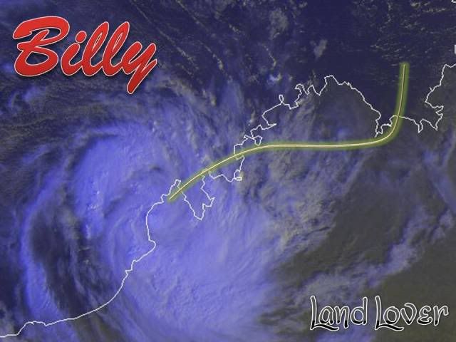
Billy was located by radar and by surface observations near the Dampier
Peninsula north of Broome, moving at a steady 10-14 km/h. While proximity to
land may be hindering development, both recent radar and IR imagery suggest an
improving degree of organisation. However, the curved band analysis of 0.5-0.6
is highly subjective. Dvorak FT of 3.0 supported by MET.
Intensification is forecast in the next 24 to 72 hours as Billy moves over warm
open waters in a reasonably favourable shear environment. Being a compact
system, Billy is likely to be very responsive to changes in the environment
including relatively moderate amounts of shear. There has been evidence of a
southerly tilt on the inner core as ascertained by comparing satellite imagery,
and radar imagery at a range in excess of 200 km [and hence above 15000ft], with
subjective observations from people on Cockatoo Island some 6-12 hours ago.
Model guidance is consistent with a steady WSW track to 24 hours than W'ly track
in the 24-72 hour timeframe, off the Pilbara coast, under the influence of a
mid-level ridge to the south. However, motion is partially dependent on the
erosion of the peripheral ridge by the system currently in the Gulf of
Carpentaria, hence the risk of a Pilbara coastal impact can not be dismissed.
==
The next bulletin for this system will be issued by: 23/0100 UTC by Perth TCWC.
Issued by PERTH TROPICAL CYCLONE WARNING CENTRE
at: 1922 UTC 22/12/2008
Name: Billy
Data At: 1800 UTC
Latitude: 16.6S
Longitude: 122.8E
Location Accuracy: within 30 nm [55 km]
Movement Towards: west southwest [241 deg]
Speed of Movement: 7 knots [13 km/h]
Maximum 10-Minute Wind: 40 knots [75 km/h]
Maximum 3-Second Wind Gust: 55 knots [100 km/h]
Central Pressure: 990 hPa
Radius of 34-knot winds NE quadrant: 70 nm [130 km]
Radius of 34-knot winds SE quadrant: 40 nm [75 km]
Radius of 34-knot winds SW quadrant: 40 nm [75 km]
Radius of 34-knot winds NW quadrant: 70 nm [130 km]
Radius of 48-knot winds NE quadrant:
Radius of 48-knot winds SE quadrant:
Radius of 48-knot winds SW quadrant:
Radius of 48-knot winds NW quadrant:
Radius of 64-knot winds:
Radius of Maximum Winds: 20 nm [37 km]
Dvorak Intensity Code: T3.0/3.0/D0.5/24HRS
Pressure of outermost isobar: 1002 hPa
Radius of outermost closed isobar: 120 nm [220 km]
Storm Depth: Deep
FORECAST DATA
Date/Time : Location : Loc. Accuracy: Max Wind : Central Pressure
[UTC] : degrees : nm [km]: knots[km/h]: hPa
+12: 23/0600: 17.2S 121.7E: 055 [100]: 050 [095]: 985
+24: 23/1800: 17.4S 120.6E: 080 [150]: 060 [110]: 978
+36: 24/0600: 17.5S 119.3E: 115 [215]: 065 [120]: 975
+48: 24/1800: 17.4S 118.0E: 135 [250]: 075 [140]: 967
+60: 25/0600: 17.4S 116.6E: 180 [335]: 080 [150]: 962
+72: 25/1800: 17.1S 115.5E: 230 [425]: 080 [150]: 962
REMARKS:
Billy was located by radar and by surface observations near the Dampier
Peninsula north of Broome, moving at a steady 10-14 km/h. While proximity to
land may be hindering development, both recent radar and IR imagery suggest an
improving degree of organisation. However, the curved band analysis of 0.5-0.6
is highly subjective. Dvorak FT of 3.0 supported by MET.
Intensification is forecast in the next 24 to 72 hours as Billy moves over warm
open waters in a reasonably favourable shear environment. Being a compact
system, Billy is likely to be very responsive to changes in the environment
including relatively moderate amounts of shear. There has been evidence of a
southerly tilt on the inner core as ascertained by comparing satellite imagery,
and radar imagery at a range in excess of 200 km [and hence above 15000ft], with
subjective observations from people on Cockatoo Island some 6-12 hours ago.
Model guidance is consistent with a steady WSW track to 24 hours than W'ly track
in the 24-72 hour timeframe, off the Pilbara coast, under the influence of a
mid-level ridge to the south. However, motion is partially dependent on the
erosion of the peripheral ridge by the system currently in the Gulf of
Carpentaria, hence the risk of a Pilbara coastal impact can not be dismissed.
==
The next bulletin for this system will be issued by: 23/0100 UTC by Perth TCWC.
0 likes
-
HURAKAN
- Professional-Met
- Posts: 46086
- Age: 37
- Joined: Thu May 20, 2004 4:34 pm
- Location: Key West, FL
- Contact:
Re: NW Australia: BILLY - Tropical Cyclone: Discussion
UW - CIMSS
ADVANCED DVORAK TECHNIQUE
ADT-Version 7.2.3
Tropical Cyclone Intensity Algorithm
----- Current Analysis -----
Date : 22 DEC 2008 Time : 183000 UTC
Lat : 16:30:59 S Lon : 122:47:31 E
CI# /Pressure/ Vmax
3.4 / 987.7mb/ 53.0kt
Final T# Adj T# Raw T#
(3hr avg)
3.4 3.5 3.5
Latitude bias adjustment to MSLP : +2.3mb
Center Temp : -56.0C Cloud Region Temp : -64.3C
Scene Type : UNIFORM CDO CLOUD REGION
Positioning Method : FORECAST INTERPOLATION
Ocean Basin : INDIAN
Dvorak CI > MSLP Conversion Used : PACIFIC
Tno/CI Rules : Constraint Limits : NO LIMIT
Weakening Flag : OFF
Rapid Dissipation Flag : OFF
0 likes


AXAU01 APRF 230046
IDW27600
TROPICAL CYCLONE TECHNICAL BULLETIN: AUSTRALIA - WESTERN REGION
Issued by PERTH TROPICAL CYCLONE WARNING CENTRE
at: 0046 UTC 23/12/2008
Name: Billy
Data At: 0000 UTC
Latitude: 17.2S
Longitude: 122.2E
Location Accuracy: within 30 nm [55 km]
Movement Towards: southwest [231 deg]
Speed of Movement: 8 knots [15 km/h]
Maximum 10-Minute Wind: 40 knots [75 km/h]
Maximum 3-Second Wind Gust: 55 knots [100 km/h]
Central Pressure: 988 hPa
Radius of 34-knot winds NE quadrant: 70 nm [130 km]
Radius of 34-knot winds SE quadrant: 35 nm [65 km]
Radius of 34-knot winds SW quadrant: 50 nm [95 km]
Radius of 34-knot winds NW quadrant: 70 nm [130 km]
Radius of 48-knot winds NE quadrant:
Radius of 48-knot winds SE quadrant:
Radius of 48-knot winds SW quadrant:
Radius of 48-knot winds NW quadrant:
Radius of 64-knot winds:
Radius of Maximum Winds: 20 nm [37 km]
Dvorak Intensity Code: T3.0/3.0/S1.0/24HRS
Pressure of outermost isobar: 998 hPa
Radius of outermost closed isobar: 70 nm [130 km]
Storm Depth: Deep
FORECAST DATA
Date/Time : Location : Loc. Accuracy: Max Wind : Central Pressure
[UTC] : degrees : nm [km]: knots[km/h]: hPa
+12: 23/1200: 17.8S 121.1E: 060 [110]: 050 [095]: 981
+24: 24/0000: 17.8S 119.9E: 090 [165]: 055 [100]: 978
+36: 24/1200: 17.9S 118.6E: 120 [225]: 060 [110]: 974
+48: 25/0000: 17.6S 117.0E: 155 [285]: 070 [130]: 967
+60: 25/1200: 17.5S 116.0E: 200 [375]: 075 [140]: 962
+72: 26/0000: 16.9S 114.8E: 250 [465]: 075 [140]: 962
REMARKS:
Billy was located by radar and by surface observations near the Dampier
Peninsula north of Broome, moving at a steady 10-14 km/h. While proximity to
land may be hindering development, both recent radar and IR imagery suggest an
improving degree of organisation. However, the curved band analysis of 0.5-0.6
is highly subjective. Dvorak FT of 3.0 supported by MET.
Intensification is forecast in the next 24 to 72 hours as Billy moves over warm
open waters in a reasonably favourable shear environment.
Model guidance is consistent with a steady WSW track to 24 hours then a W'ly
track in the 24-72 hour timeframe, well off the Pilbara coast, under the
influence of a mid-level ridge to the south. However, motion is partially
dependent on the erosion of the peripheral ridge by the system currently over
the Top End, hence the risk of a Pilbara coastal impact can not be dismissed.
==
The next bulletin for this system will be issued by: 23/0700 UTC by Perth TCWC.
0 likes
-
HURAKAN
- Professional-Met
- Posts: 46086
- Age: 37
- Joined: Thu May 20, 2004 4:34 pm
- Location: Key West, FL
- Contact:
Australian Government Bureau of Meteorology
Western Australia
Media: The Standard Emergency Warning Signal should NOT be used with this
warning.
TOP PRIORITY FOR IMMEDIATE BROADCAST
TROPICAL CYCLONE ADVICE NUMBER 43
Issued at 9:55 am WDT on Tuesday, 23 December 2008
BY THE BUREAU OF METEOROLOGY
TROPICAL CYCLONE WARNING CENTRE PERTH
A Cyclone WARNING is current for coastal and island communities from Cockatoo
Island to De Grey.
A Cyclone WATCH is current for coastal areas from De Grey to Mardie.
The Cyclone WARNING between Cockatoo Island and Kuri Bay has been CANCELLED.
At 9:00 am WDT Tropical Cyclone Billy was estimated to be
85 kilometres north of Broome and
55 kilometres west southwest of Beagle Bay and
moving southwest at 15 kilometres per hour.
TC Billy is currently located north of Broome on the northwest Kimberley coast.
Billy is expected to begin to move away from the Kimberley coast today and take
a more west southwest track.
GALES with gusts to 100 kilometres per hour are likely about the Dampier
Peninsula including Broome today before easing this evening. GALES may extend to
the Pilbara coast east of De Grey during Wednesday, particularly if Billy takes
a more southwest track than forecast.
Widespread heavy rainfall is expected over the southwest Kimberley, with
significant stream rises and local flooding. Rainfall should gradually ease as
Billy moves away from the coast later today.
Details of Tropical Cyclone Billy at 9:00 am WDT:
.Centre located near...... 17.2 degrees South 122.2 degrees East
.Location accuracy........ within 55 kilometres
.Recent movement.......... towards the southwest at 15 kilometres per hour
.Wind gusts near centre... 100 kilometres per hour
.Severity category........ 1
.Central pressure......... 988 hectoPascals
FESA-State Emergency Service advises of the following community alerts:
YELLOW ALERT: People in or near the community of Beagle Bay should be taking
action in preparation for the cyclone's arrival.
BLUE ALERT: People in or near the communities between Cockatoo Island and
Lombadina and between Broome and Wallal should start taking precautions. The
community of Derby is NOT included.
People in communities between Wallal and Mardie should listen for the next
advice.
The next advice will be issued by 1:00 pm WDT Tuesday 23 December.
Cyclone advices and State Emergency Service Community Alerts are available by
dialling 1300 659 210
A map showing the track of the cyclone is available at:
http://www.bom.gov.au/weather/cyclone
0 likes
-
HURAKAN
- Professional-Met
- Posts: 46086
- Age: 37
- Joined: Thu May 20, 2004 4:34 pm
- Location: Key West, FL
- Contact:
Australian Government Bureau of Meteorology
Western Australia
Media: The Standard Emergency Warning Signal should NOT be used with this
warning.
TOP PRIORITY FOR IMMEDIATE BROADCAST
TROPICAL CYCLONE ADVICE NUMBER 44
Issued at 12:40 pm WDT on Tuesday, 23 December 2008
BY THE BUREAU OF METEOROLOGY
TROPICAL CYCLONE WARNING CENTRE PERTH
A Cyclone WARNING is current for coastal and island communities from Cockatoo
Island to De Grey.
A Cyclone WATCH is current for coastal areas from De Grey to Mardie.
At 12:00 pm WDT Tropical Cyclone Billy was estimated to be
60 kilometres northwest of Broome and
115 kilometres southwest of Beagle Bay and
moving southwest at 17 kilometres per hour.
TC Billy is currently located northwest of Broome and is expected to move away
from the Kimberley coast today. In the next 24 hours the cyclone is expected to
move in a more westerly direction.
GALES with gusts to 100 kilometres per hour are likely about the Dampier
Peninsula including Broome today before easing this evening. GALES may extend to
the Pilbara coast east of De Grey during Wednesday, particularly if Billy takes
a more southwest track than forecast.
Widespread heavy rainfall is expected over the southwest Kimberley, with
significant stream rises and local flooding. Rainfall should gradually ease as
Billy moves away from the coast later today.
Details of Tropical Cyclone Billy at 12:00 pm WDT:
.Centre located near...... 17.6 degrees South 121.8 degrees East
.Location accuracy........ within 55 kilometres
.Recent movement.......... towards the southwest at 17 kilometres per hour
.Wind gusts near centre... 100 kilometres per hour
.Severity category........ 1
.Central pressure......... 988 hectoPascals
FESA-State Emergency Service advises of the following community alerts:
BLUE ALERT: People in or near the communities between Beagle Bay and Wallal
should start taking precautions.
ALL CLEAR WITH CAUTION: People in or near communities between Cockatoo Island
and Lombadina are advised to proceed with caution.
People in communities between Wallal and Mardie should listen for the next
advice.
The next advice will be issued by 4:00 pm WDT Tuesday 23 December.
Cyclone advices and State Emergency Service Community Alerts are available by
dialling 1300 659 210
A map showing the track of the cyclone is available at:
http://www.bom.gov.au/weather/cyclone
0 likes
-
Crostorm

- Category 5

- Posts: 2060
- Age: 49
- Joined: Mon Dec 25, 2006 3:51 pm
- Location: Croatia-Europe
- Contact:
IDW24100
Australian Government Bureau of Meteorology
Western Australia
Media: The Standard Emergency Warning Signal should NOT be used with this
warning.
TOP PRIORITY FOR IMMEDIATE BROADCAST
TROPICAL CYCLONE ADVICE NUMBER 46
Issued at 6:50 pm WDT on Tuesday, 23 December 2008
BY THE BUREAU OF METEOROLOGY
TROPICAL CYCLONE WARNING CENTRE PERTH
A Cyclone WARNING is current for coastal and island communities from Beagle Bay
to Whim Creek.
A Cyclone WATCH is current for coastal areas from Whim Creek to Mardie.
At 6:00 pm WDT Tropical Cyclone Billy was estimated to be
125 kilometres west northwest of Broome and
395 kilometres northeast of Port Hedland and
moving west southwest at 15 kilometres per hour.
TC Billy is currently located west northwest of Broome and is now moving away
from the Kimberley coast. In the next 24 hours the cyclone is expected to move
in a generally westerly direction.
GALES with gusts to 100 kilometres per hour are possible north of Broome about
western parts of the Dampier Peninsula this evening, but will ease tonight.
GALES may develop along the Pilbara coast east of Whim Creek during Wednesday if
Billy takes a more southwest track than forecast.
Rainfall is expected to ease over the southwest Kimberley tonight as the cyclone
moves away from the coast.
Details of Tropical Cyclone Billy at 6:00 pm WDT:
.Centre located near...... 17.7 degrees South 121.1 degrees East
.Location accuracy........ within 35 kilometres
.Recent movement.......... towards the west southwest at 15 kilometres per hour
.Wind gusts near centre... 100 kilometres per hour
.Severity category........ 1
.Central pressure......... 987 hectoPascals
FESA-State Emergency Service advises of the following community alerts:
BLUE ALERT: People in or near communities from Beagle Bay to Port Hedland should
take precautions.
People in communities between Port Hedland and Mardie should listen for the next
advice.
The next advice will be issued by 10:00 pm WDT Tuesday 23 December.
Cyclone advices and State Emergency Service Community Alerts are available by
dialling 1300 659 210
A map showing the track of the cyclone is available at:
http://www.bom.gov.au/weather/cyclone
0 likes
-
HURAKAN
- Professional-Met
- Posts: 46086
- Age: 37
- Joined: Thu May 20, 2004 4:34 pm
- Location: Key West, FL
- Contact:

WTXS32 PGTW 231500
MSGID/GENADMIN/NAVMARFCSTCEN PEARL HARBOR HI/JTWC//
SUBJ/TROPICAL CYCLONE 05S (BILLY) WARNING NR 011//
RMKS/
1. TROPICAL CYCLONE 05S (BILLY) WARNING NR 011
01 ACTIVE TROPICAL CYCLONE IN SOUTHIO
MAX SUSTAINED WINDS BASED ON ONE-MINUTE AVERAGE
---
WARNING POSITION:
231200Z --- NEAR 17.7S 120.8E
MOVEMENT PAST SIX HOURS - 260 DEGREES AT 05 KTS
POSITION ACCURATE TO WITHIN 040 NM
POSITION BASED ON CENTER LOCATED BY A COMBINATION OF
SATELLITE AND RADAR
PRESENT WIND DISTRIBUTION:
MAX SUSTAINED WINDS - 050 KT, GUSTS 065 KT
WIND RADII VALID OVER OPEN WATER ONLY
RADIUS OF 034 KT WINDS - 045 NM NORTHEAST QUADRANT
060 NM SOUTHEAST QUADRANT
055 NM SOUTHWEST QUADRANT
045 NM NORTHWEST QUADRANT
REPEAT POSIT: 17.7S 120.8E
---
FORECASTS:
12 HRS, VALID AT:
240000Z --- 17.8S 119.5E
MAX SUSTAINED WINDS - 060 KT, GUSTS 075 KT
WIND RADII VALID OVER OPEN WATER ONLY
RADIUS OF 050 KT WINDS - 030 NM NORTHEAST QUADRANT
030 NM SOUTHEAST QUADRANT
030 NM SOUTHWEST QUADRANT
030 NM NORTHWEST QUADRANT
RADIUS OF 034 KT WINDS - 055 NM NORTHEAST QUADRANT
070 NM SOUTHEAST QUADRANT
065 NM SOUTHWEST QUADRANT
055 NM NORTHWEST QUADRANT
VECTOR TO 24 HR POSIT: 270 DEG/ 07 KTS
---
24 HRS, VALID AT:
241200Z --- 17.8S 118.0E
MAX SUSTAINED WINDS - 070 KT, GUSTS 085 KT
WIND RADII VALID OVER OPEN WATER ONLY
RADIUS OF 064 KT WINDS - 020 NM NORTHEAST QUADRANT
020 NM SOUTHEAST QUADRANT
020 NM SOUTHWEST QUADRANT
020 NM NORTHWEST QUADRANT
RADIUS OF 050 KT WINDS - 035 NM NORTHEAST QUADRANT
035 NM SOUTHEAST QUADRANT
035 NM SOUTHWEST QUADRANT
035 NM NORTHWEST QUADRANT
RADIUS OF 034 KT WINDS - 065 NM NORTHEAST QUADRANT
080 NM SOUTHEAST QUADRANT
075 NM SOUTHWEST QUADRANT
065 NM NORTHWEST QUADRANT
VECTOR TO 36 HR POSIT: 280 DEG/ 07 KTS
---
36 HRS, VALID AT:
250000Z --- 17.5S 116.5E
MAX SUSTAINED WINDS - 075 KT, GUSTS 090 KT
WIND RADII VALID OVER OPEN WATER ONLY
RADIUS OF 064 KT WINDS - 025 NM NORTHEAST QUADRANT
025 NM SOUTHEAST QUADRANT
025 NM SOUTHWEST QUADRANT
025 NM NORTHWEST QUADRANT
RADIUS OF 050 KT WINDS - 040 NM NORTHEAST QUADRANT
040 NM SOUTHEAST QUADRANT
040 NM SOUTHWEST QUADRANT
040 NM NORTHWEST QUADRANT
RADIUS OF 034 KT WINDS - 070 NM NORTHEAST QUADRANT
085 NM SOUTHEAST QUADRANT
080 NM SOUTHWEST QUADRANT
070 NM NORTHWEST QUADRANT
VECTOR TO 48 HR POSIT: 290 DEG/ 08 KTS
---
EXTENDED OUTLOOK:
48 HRS, VALID AT:
251200Z --- 17.0S 115.0E
MAX SUSTAINED WINDS - 075 KT, GUSTS 090 KT
WIND RADII VALID OVER OPEN WATER ONLY
RADIUS OF 064 KT WINDS - 025 NM NORTHEAST QUADRANT
025 NM SOUTHEAST QUADRANT
025 NM SOUTHWEST QUADRANT
025 NM NORTHWEST QUADRANT
RADIUS OF 050 KT WINDS - 040 NM NORTHEAST QUADRANT
040 NM SOUTHEAST QUADRANT
040 NM SOUTHWEST QUADRANT
040 NM NORTHWEST QUADRANT
RADIUS OF 034 KT WINDS - 070 NM NORTHEAST QUADRANT
085 NM SOUTHEAST QUADRANT
080 NM SOUTHWEST QUADRANT
070 NM NORTHWEST QUADRANT
VECTOR TO 72 HR POSIT: 285 DEG/ 04 KTS
---
72 HRS, VALID AT:
261200Z --- 16.6S 113.3E
MAX SUSTAINED WINDS - 070 KT, GUSTS 085 KT
WIND RADII VALID OVER OPEN WATER ONLY
RADIUS OF 064 KT WINDS - 020 NM NORTHEAST QUADRANT
020 NM SOUTHEAST QUADRANT
020 NM SOUTHWEST QUADRANT
020 NM NORTHWEST QUADRANT
RADIUS OF 050 KT WINDS - 035 NM NORTHEAST QUADRANT
035 NM SOUTHEAST QUADRANT
035 NM SOUTHWEST QUADRANT
035 NM NORTHWEST QUADRANT
RADIUS OF 034 KT WINDS - 065 NM NORTHEAST QUADRANT
080 NM SOUTHEAST QUADRANT
075 NM SOUTHWEST QUADRANT
065 NM NORTHWEST QUADRANT
---
REMARKS:
231500Z POSITION NEAR 17.7S 120.5E.
TROPICAL CYCLONE (TC) 05S (BILLY), LOCATED APPROXIMATELY 465 NM
NORTHEAST OF LEARMONTH, AUSTRALIA, HAS TRACKED WESTWARD AT 05 KNOTS
OVER THE PAST SIX HOURS. RECENT ANIMATED RADAR IMAGERY FROM BROOME,
AUSTRALIA, AS WELL AS MICROWAVE AND GEOSTATIONARY SATELLITE POSITION
ESTIMATES, INDICATE THAT TC 05S HAS BEGUN AN ANTICIPATED WESTWARD
TURN DURING THE PAST 12 HOURS. THE CYCLONE IS NOW TRACKING WESTWARD
UNDER THE STEERING INFLUENCE OF A VERTICALLY DEEP SUBTROPICAL RIDGE
EXTENSION TO THE SOUTH. FORWARD MOTION HAS SLOWED AS THE SYSTEM
NEARS A WEAKNESS BETWEEN THE CURRENT STEERING RIDGE AND A SECOND
SUBTROPICAL RIDGE TO THE WEST. BY TAU 24, THE SECOND RIDGE TO THE
WEST IS EXPECTED TO EXERT AN INCREASING INFLUENCE ON STORM MOTION,
CARRYING THE SYSTEM ON A WEST-NORTHWESTWARD TRACK AWAY FROM THE
WESTERN AUSTRALIA COAST. THIS TRACK FORECAST IS SUPPORTED BY ALL OF
THE AVAILABLE NUMERICAL MODEL GUIDANCE. FORWARD TRACK SPEEDS HAVE
BEEN DECREASED SLIGHTLY FROM THE PREVIOUS FORECAST GIVEN THE CURRENT
SLOWDOWN AND THE ANTICIPATED CHANGE OF PRIMARY STEERING INFLUENCE.
TC 05S WILL INTENSIFY STEADILY OVER THE NEXT 36 HOURS AS THE STORM
MOVES UNDER AN UPPER LEVEL ANTICYCLONE AXIS INTO A REGION OF LOW TO
MODERATE VERTICAL WIND SHEAR SHEAR AND STRONG POLEWARD OUTFLOW.
AFTER TAU 36, STORM INTENSITY WILL BEGIN TO DECREASE AS INCREASING
VERTICAL WIND SHEAR AND PASSAGE OVER SOMEWHAT COOLER WATER TAKE
THEIR TOLL. MAXIMUM SIGNIFICANT WAVE HEIGHT AT 231200Z IS 13 FEET.
NEXT WARNINGS AT 240300Z AND 241500Z.//
NNNN
0 likes

-
HURAKAN
- Professional-Met
- Posts: 46086
- Age: 37
- Joined: Thu May 20, 2004 4:34 pm
- Location: Key West, FL
- Contact:
TROPICAL CYCLONE ADVICE NUMBER 49
Issued at 3:45 am WDT on Wednesday, 24 December 2008
BY THE BUREAU OF METEOROLOGY
TROPICAL CYCLONE WARNING CENTRE PERTH
A Cyclone WARNING is current for coastal communities from Bidyadanga to Whim
Creek.
A Cyclone WATCH is current for coastal areas from Whim Creek to Mardie.
The Cyclone WARNING from Beagle Bay to Bidyadanga has been cancelled.
At 3:00 am WDT Tropical Cyclone Billy was estimated to be
205 kilometres west of Broome and
325 kilometres north northeast of Port Hedland and
moving west southwest at 10 kilometres per hour.
TC Billy is currently located west of Broome and is moving away from the
Kimberley coast. In the next 24 hours the cyclone is expected to move in a
generally westerly direction.
GALES with gusts to 100 kilometres per hour may develop between Bidyadanga and
Whim Creek during Wednesday if Billy takes a more southwest track.
Rainfall is expected to ease over the southwest Kimberley during Wednesday as
the cyclone moves away from the coast.
Details of Tropical Cyclone Billy at 3:00 am WDT:
.Centre located near...... 17.9 degrees South 120.3 degrees East
.Location accuracy........ within 28 kilometres
.Recent movement.......... towards the west southwest at 10 kilometres per hour
.Wind gusts near centre... 120 kilometres per hour
.Severity category........ 1
.Central pressure......... 986 hectoPascals
FESA-State Emergency Service advises of the following community alerts:
BLUE ALERT: People in or near communities from Bidyadanga to Port Hedland should
take precautions.
People in communities between Port Hedland and Mardie should listen for the next
advice.
The next advice will be issued by 7:00 am WDT Wednesday 24 December.
Cyclone advices and State Emergency Service Community Alerts are available by
dialling 1300 659 210
A map showing the track of the cyclone is available at:
http://www.bom.gov.au/weather/cyclone
0 likes


-
HURAKAN
- Professional-Met
- Posts: 46086
- Age: 37
- Joined: Thu May 20, 2004 4:34 pm
- Location: Key West, FL
- Contact:
Australian Government Bureau of Meteorology
Western Australia
Media: The Standard Emergency Warning Signal should NOT be used with this
warning.
TOP PRIORITY FOR IMMEDIATE BROADCAST
TROPICAL CYCLONE ADVICE NUMBER 50
Issued at 6:45 am WDT on Wednesday, 24 December 2008
BY THE BUREAU OF METEOROLOGY
TROPICAL CYCLONE WARNING CENTRE PERTH
A Cyclone WARNING is current for coastal communities from Wallal to Whim Creek.
A Cyclone WATCH is current for coastal areas from Whim Creek to Mardie.
The Cyclone WARNING from Bidyadanga to Wallal has been cancelled.
At 6:00 am WDT Tropical Cyclone Billy was estimated to be
235 kilometres west of Broome and
315 kilometres north northeast of Port Hedland and
moving west at 10 kilometres per hour.
TC Billy is currently located west of Broome and is moving away from the
Kimberley coast. In the next 24 hours the cyclone is expected to move in a
generally westerly direction.
GALES with gusts to 100 kilometres per hour may develop between Wallal and Whim
Creek during Wednesday if Billy takes a more southwest track.
Rainfall is expected to ease over the southwest Kimberley during Wednesday as
the cyclone moves away from the coast.
Details of Tropical Cyclone Billy at 6:00 am WDT:
.Centre located near...... 17.8 degrees South 120.0 degrees East
.Location accuracy........ within 28 kilometres
.Recent movement.......... towards the west at 10 kilometres per hour
.Wind gusts near centre... 130 kilometres per hour
.Severity category........ 2
.Central pressure......... 983 hectoPascals
FESA-State Emergency Service advises of the following community alerts:
BLUE ALERT: People in or near communities from Pardoo to Port Hedland and
surrounding communities should take precautions.
People in communities between Port Hedland and Mardie should listen for the next
advice.
The next advice will be issued by 10:00 am WDT Wednesday 24 December.
Cyclone advices and State Emergency Service Community Alerts are available by
dialling 1300 659 210
A map showing the track of the cyclone is available at:
http://www.bom.gov.au/weather/cyclone
0 likes
-
HURAKAN
- Professional-Met
- Posts: 46086
- Age: 37
- Joined: Thu May 20, 2004 4:34 pm
- Location: Key West, FL
- Contact:
Re: NW Australia: BILLY - Tropical Cyclone: Discussion
TROPICAL CYCLONE ADVICE NUMBER 51
Issued at 10:15 am WDT on Wednesday, 24 December 2008
BY THE BUREAU OF METEOROLOGY
TROPICAL CYCLONE WARNING CENTRE PERTH
A Cyclone WARNING is current for coastal communities from Pardoo to Mardie.
The Cyclone WARNING from Wallal to Pardoo has been cancelled.
At 9:00 am WDT Tropical Cyclone Billy was estimated to be
310 kilometres north northeast of Port Hedland and
250 kilometres west of Broome and
moving west at 8 kilometres per hour.
TC Billy is currently located well west of Broome and is moving away from the
Kimberley and Pilbara coasts. In the next 24 hours the cyclone is expected to
move in a generally westerly direction.
GALES with gusts to 100 kilometres per hour may develop between Pardoo and
Mardie during Wednesday night and early Thursday but only if Billy takes a more
southwesterly track than expected.
Rainfall is expected to ease over the southwest Kimberley during today as the
cyclone moves further away from the coast.
Details of Tropical Cyclone Billy at 9:00 am WDT:
.Centre located near...... 17.8 degrees South 119.9 degrees East
.Location accuracy........ within 28 kilometres
.Recent movement.......... towards the west at 8 kilometres per hour
.Wind gusts near centre... 155 kilometres per hour
.Severity category........ 2
.Central pressure......... 975 hectoPascals
FESA-State Emergency Service advises of the following community alerts:
BLUE ALERT: People in or near communities from Pardoo to Port Hedland and
surrounding communities should take precautions.
People in communities between Port Hedland and Mardie should listen for the next
advice.
The next advice will be issued by 1:00 pm WDT Wednesday 24 December.
Cyclone advices and State Emergency Service Community Alerts are available by
dialling 1300 659 210
A map showing the track of the cyclone is available at:
http://www.bom.gov.au/weather/cyclone
0 likes
-
HURAKAN
- Professional-Met
- Posts: 46086
- Age: 37
- Joined: Thu May 20, 2004 4:34 pm
- Location: Key West, FL
- Contact:
TROPICAL CYCLONE TECHNICAL BULLETIN: AUSTRALIA - WESTERN REGION
Issued by PERTH TROPICAL CYCLONE WARNING CENTRE
at: 0113 UTC 24/12/2008
Name: Billy
Data At: 0000 UTC
Latitude: 17.8S
Longitude: 119.9E
Location Accuracy: within 15 nm [28 km]
Movement Towards: west [270 deg]
Speed of Movement: 4 knots [8 km/h]
Maximum 10-Minute Wind: 60 knots [110 km/h]
Maximum 3-Second Wind Gust: 85 knots [155 km/h]
Central Pressure: 975 hPa
Radius of 34-knot winds NE quadrant: 70 nm [130 km]
Radius of 34-knot winds SE quadrant: 70 nm [130 km]
Radius of 34-knot winds SW quadrant: 70 nm [130 km]
Radius of 34-knot winds NW quadrant: 70 nm [130 km]
Radius of 48-knot winds NE quadrant: 25 nm [46 km]
Radius of 48-knot winds SE quadrant: 25 nm [46 km]
Radius of 48-knot winds SW quadrant: 25 nm [46 km]
Radius of 48-knot winds NW quadrant: 25 nm [46 km]
Radius of 64-knot winds:
Radius of Maximum Winds: 20 nm [37 km]
Dvorak Intensity Code: T4.0/4.0/D1.0/24HRS
Pressure of outermost isobar: 1000 hPa
Radius of outermost closed isobar: 80 nm [150 km]
Storm Depth: Deep
FORECAST DATA
Date/Time : Location : Loc. Accuracy: Max Wind : Central Pressure
[UTC] : degrees : nm [km]: knots[km/h]: hPa
+12: 24/1200: 17.8S 118.5E: 045 [085]: 070 [130]: 969
+24: 25/0000: 17.4S 117.0E: 075 [140]: 080 [150]: 960
+36: 25/1200: 17.0S 115.8E: 110 [200]: 080 [150]: 960
+48: 26/0000: 16.2S 114.6E: 140 [260]: 080 [150]: 960
+60: 26/1200: 15.5S 113.5E: 190 [350]: 070 [130]: 968
+72: 27/0000: 15.2S 112.0E: 235 [435]: 060 [110]: 977
REMARKS:
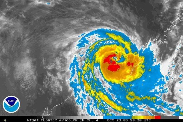
Billy was located by radar west of Broome moving steadily west, although clearly
undergoing trochoidal oscillation along the mean track. Recent imagery suggests
continuing intensification with the apparent formation of an eye but
contstrained by MET to a CI of 4.0.
Intensifaction is expected to continue over the next 24 hours as Billy moves
west in a favourable environment.
Model guidance is consistent with a steady W'ly track then a W/NW track in the
24-72 hour timeframe, well off the Pilbara coast under the influence of a
mid-level ridge to the south.
It appears less likely that Billy will take a track closer to the Pilbara coast,
but a small risk of gales remains for coastal parts of the Pilbara.
==
The next bulletin for this system will be issued by: 24/0700 UTC by Perth TCWC.
Issued by PERTH TROPICAL CYCLONE WARNING CENTRE
at: 0113 UTC 24/12/2008
Name: Billy
Data At: 0000 UTC
Latitude: 17.8S
Longitude: 119.9E
Location Accuracy: within 15 nm [28 km]
Movement Towards: west [270 deg]
Speed of Movement: 4 knots [8 km/h]
Maximum 10-Minute Wind: 60 knots [110 km/h]
Maximum 3-Second Wind Gust: 85 knots [155 km/h]
Central Pressure: 975 hPa
Radius of 34-knot winds NE quadrant: 70 nm [130 km]
Radius of 34-knot winds SE quadrant: 70 nm [130 km]
Radius of 34-knot winds SW quadrant: 70 nm [130 km]
Radius of 34-knot winds NW quadrant: 70 nm [130 km]
Radius of 48-knot winds NE quadrant: 25 nm [46 km]
Radius of 48-knot winds SE quadrant: 25 nm [46 km]
Radius of 48-knot winds SW quadrant: 25 nm [46 km]
Radius of 48-knot winds NW quadrant: 25 nm [46 km]
Radius of 64-knot winds:
Radius of Maximum Winds: 20 nm [37 km]
Dvorak Intensity Code: T4.0/4.0/D1.0/24HRS
Pressure of outermost isobar: 1000 hPa
Radius of outermost closed isobar: 80 nm [150 km]
Storm Depth: Deep
FORECAST DATA
Date/Time : Location : Loc. Accuracy: Max Wind : Central Pressure
[UTC] : degrees : nm [km]: knots[km/h]: hPa
+12: 24/1200: 17.8S 118.5E: 045 [085]: 070 [130]: 969
+24: 25/0000: 17.4S 117.0E: 075 [140]: 080 [150]: 960
+36: 25/1200: 17.0S 115.8E: 110 [200]: 080 [150]: 960
+48: 26/0000: 16.2S 114.6E: 140 [260]: 080 [150]: 960
+60: 26/1200: 15.5S 113.5E: 190 [350]: 070 [130]: 968
+72: 27/0000: 15.2S 112.0E: 235 [435]: 060 [110]: 977
REMARKS:
Billy was located by radar west of Broome moving steadily west, although clearly
undergoing trochoidal oscillation along the mean track. Recent imagery suggests
continuing intensification with the apparent formation of an eye but
contstrained by MET to a CI of 4.0.
Intensifaction is expected to continue over the next 24 hours as Billy moves
west in a favourable environment.
Model guidance is consistent with a steady W'ly track then a W/NW track in the
24-72 hour timeframe, well off the Pilbara coast under the influence of a
mid-level ridge to the south.
It appears less likely that Billy will take a track closer to the Pilbara coast,
but a small risk of gales remains for coastal parts of the Pilbara.
==
The next bulletin for this system will be issued by: 24/0700 UTC by Perth TCWC.
0 likes

Who is online
Users browsing this forum: No registered users and 38 guests