Australia: DOMINIC - Ex. Tropical Cyclone
Moderator: S2k Moderators
-
somethingfunny

- ChatStaff

- Posts: 3926
- Age: 35
- Joined: Thu May 31, 2007 10:30 pm
- Location: McKinney, Texas
-
HURAKAN

- Professional-Met

- Posts: 46086
- Age: 37
- Joined: Thu May 20, 2004 4:34 pm
- Location: Key West, FL
- Contact:
Australian Government Bureau of Meteorology
Western Australia
Media: The Standard Emergency Warning Signal should NOT be used with this
warning.
TOP PRIORITY FOR IMMEDIATE BROADCAST
TROPICAL CYCLONE ADVICE NUMBER 20
Issued at 12:40 pm WDT on Tuesday, 27 January 2009
BY THE BUREAU OF METEOROLOGY
TROPICAL CYCLONE WARNING CENTRE PERTH
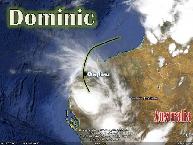
A Cyclone WARNING is current for an area inland from Onslow extending southeast
to include Nanutarra.
At midday WDT Tropical Cyclone Dominic, Category 1 was estimated to be
50 kilometres south southeast of Onslow and
60 kilometres north northwest of Nanutarra and
moving south southeast at 10 kilometres per hour.
Tropical Cyclone Dominic crossed the coast near Onslow just after 7am WDT this
morning. Dominic is rapidly weakening as it moves further inland and only a
small area of the western Pilbara, inland from Onslow and extending to
Nanutarra, remains under threat of damaging wind gusts to 100 kilometres per
hour during the afternoon. The system is expected to weaken below cyclone
intensity in the next three to six hours.
Rain is rapidly easing although localised heavy falls with thunderstorms are
possible during the afternoon.
Details of Tropical Cyclone Dominic at midday WDT:
.Centre located near...... 22.0 degrees South 115.4 degrees East
.Location accuracy........ within 35 kilometres
.Recent movement.......... towards the south southeast at 10 kilometres per hour
.Wind gusts near centre... 100 kilometres per hour
.Severity category........ 1
.Central pressure......... 983 hectoPascals
FESA-State Emergency Service advises of the following community alerts:
BLUE ALERT: People in or near Nanutarra should continue taking precautions.
ALL CLEAR WITH CAUTION: People in Onslow are advised to proceed with caution.
The next advice will be issued by 4:00 pm WDT Tuesday 27 January.
Cyclone advices and State Emergency Service Community Alerts are available by
dialling 1300 659 210
A map showing the track of the cyclone is available at:
http://www.bom.gov.au/weather/cyclone
Western Australia
Media: The Standard Emergency Warning Signal should NOT be used with this
warning.
TOP PRIORITY FOR IMMEDIATE BROADCAST
TROPICAL CYCLONE ADVICE NUMBER 20
Issued at 12:40 pm WDT on Tuesday, 27 January 2009
BY THE BUREAU OF METEOROLOGY
TROPICAL CYCLONE WARNING CENTRE PERTH
A Cyclone WARNING is current for an area inland from Onslow extending southeast
to include Nanutarra.
At midday WDT Tropical Cyclone Dominic, Category 1 was estimated to be
50 kilometres south southeast of Onslow and
60 kilometres north northwest of Nanutarra and
moving south southeast at 10 kilometres per hour.
Tropical Cyclone Dominic crossed the coast near Onslow just after 7am WDT this
morning. Dominic is rapidly weakening as it moves further inland and only a
small area of the western Pilbara, inland from Onslow and extending to
Nanutarra, remains under threat of damaging wind gusts to 100 kilometres per
hour during the afternoon. The system is expected to weaken below cyclone
intensity in the next three to six hours.
Rain is rapidly easing although localised heavy falls with thunderstorms are
possible during the afternoon.
Details of Tropical Cyclone Dominic at midday WDT:
.Centre located near...... 22.0 degrees South 115.4 degrees East
.Location accuracy........ within 35 kilometres
.Recent movement.......... towards the south southeast at 10 kilometres per hour
.Wind gusts near centre... 100 kilometres per hour
.Severity category........ 1
.Central pressure......... 983 hectoPascals
FESA-State Emergency Service advises of the following community alerts:
BLUE ALERT: People in or near Nanutarra should continue taking precautions.
ALL CLEAR WITH CAUTION: People in Onslow are advised to proceed with caution.
The next advice will be issued by 4:00 pm WDT Tuesday 27 January.
Cyclone advices and State Emergency Service Community Alerts are available by
dialling 1300 659 210
A map showing the track of the cyclone is available at:
http://www.bom.gov.au/weather/cyclone
0 likes


AXAU01 APRF 270645
IDW27600
TROPICAL CYCLONE TECHNICAL BULLETIN: AUSTRALIA - WESTERN REGION
Issued by PERTH TROPICAL CYCLONE WARNING CENTRE
at: 0644 UTC 27/01/2009
Name: Ex-Tropical Cyclone Dominic
Data At: 0600 UTC
Latitude: 22.5S
Longitude: 115.5E
Location Accuracy: within 20 nm [37 km]
Movement Towards: south southeast [165 deg]
Speed of Movement: 6 knots [12 km/h]
Maximum 10-Minute Wind: 30 knots [55 km/h]
Maximum 3-Second Wind Gust: 45 knots [85 km/h]
Central Pressure: 994 hPa
Radius of 34-knot winds NE quadrant:
Radius of 34-knot winds SE quadrant:
Radius of 34-knot winds SW quadrant:
Radius of 34-knot winds NW quadrant:
Radius of 48-knot winds NE quadrant:
Radius of 48-knot winds SE quadrant:
Radius of 48-knot winds SW quadrant:
Radius of 48-knot winds NW quadrant:
Radius of 64-knot winds:
Radius of Maximum Winds:
Dvorak Intensity Code: N/A
Pressure of outermost isobar: 1000 hPa
Radius of outermost closed isobar: 40 nm [75 km]
Storm Depth: Shallow
FORECAST DATA
Date/Time : Location : Loc. Accuracy: Max Wind : Central Pressure
[UTC] : degrees : nm [km]: knots[km/h]: hPa
+12: 27/1800: 24.3S 116.2E: 050 [095]: 030 [050]: 996
+24: 28/0600: 26.2S 117.2E: 080 [150]: 025 [045]: 997
+36: 28/1800: 28.6S 118.8E: 115 [210]: 025 [045]: 998
+48: 29/0600: : : :
+60: 29/1800: : : :
+72: 30/0600: : : :
REMARKS:
The system continued to weaken as it moved inland. Informal observations close
to the current position indicate winds have eased below gale force.
Ex-Tropical Cyclone Dominic crossed the Pilbara coast near Onslow around 22Z.
Highest wind speed observed was a 10-minute mean wind of 53 knots gusting to 72
knots at Onslow airport. Observations in the area confirmed the system had very
small radii of storm and gale force winds.
Accumulated rainfall of 272mm was recorded at Onslow Airport, with similar
totals recorded offshore.
272 mm = 10.7 inches of rain.
0 likes
-
HURAKAN
- Professional-Met
- Posts: 46086
- Age: 37
- Joined: Thu May 20, 2004 4:34 pm
- Location: Key West, FL
- Contact:
Australian Government Bureau of Meteorology
Western Australia
Media: The Standard Emergency Warning Signal should NOT be used with this
warning.
PRIORITY
TROPICAL CYCLONE ADVICE NUMBER 21
Issued at 3:55 pm WDT on Tuesday, 27 January 2009
BY THE BUREAU OF METEOROLOGY
TROPICAL CYCLONE WARNING CENTRE PERTH
The Cyclone WARNING has been cancelled.
At 3:00 pm WDT Ex-Tropical Cyclone Dominic, was estimated to be
100 kilometres south southeast of Onslow, near Nanutarra and
moving south southeast at 12 kilometres per hour.
Ex-Tropical Cyclone Dominic crossed the coast near Onslow just after 7am WDT
this morning.
Destructive wind gusts to 135 kilometres per hour were experienced in Onslow
during the morning. However the system weakened rapidly as it moved inland and
damaging wind gusts are no longer expected.
Rain has cleared from coastal areas and is rapidly easing inland, although
localised heavy falls with squally thunderstorms are possible during the
afternoon.
Details of Ex-Tropical Cyclone Dominic at 3:00 pm WDT:
.Centre located near...... 22.5 degrees South 115.5 degrees East
.Location accuracy........ within 37 kilometres
.Recent movement.......... towards the south southeast at 12 kilometres per hour
.Wind gusts near centre... 85 kilometres per hour
.Severity category........ below cyclone intensity
.Central pressure......... 994 hectoPascals
No further advices will be issued for this system.
Cyclone advices and State Emergency Service Community Alerts are available by
dialling 1300 659 210
A map showing the track of the cyclone is available at:
http://www.bom.gov.au/weather/cyclone
0 likes
-
HURAKAN
- Professional-Met
- Posts: 46086
- Age: 37
- Joined: Thu May 20, 2004 4:34 pm
- Location: Key West, FL
- Contact:

WTXS31 PGTW 270300
MSGID/GENADMIN/NAVMARFCSTCEN PEARL HARBOR HI/JTWC//
SUBJ/TROPICAL CYCLONE 10S (DOMINIC) WARNING NR 007//
RMKS/
1. TROPICAL CYCLONE 10S (DOMINIC) WARNING NR 007
01 ACTIVE TROPICAL CYCLONE IN SOUTHIO
MAX SUSTAINED WINDS BASED ON ONE-MINUTE AVERAGE
---
WARNING POSITION:
270000Z --- NEAR 21.9S 115.3E
MOVEMENT PAST SIX HOURS - 170 DEGREES AT 06 KTS
POSITION ACCURATE TO WITHIN 060 NM
POSITION BASED ON CENTER LOCATED BY A COMBINATION OF
SATELLITE AND RADAR
PRESENT WIND DISTRIBUTION:
MAX SUSTAINED WINDS - 045 KT, GUSTS 055 KT
WIND RADII VALID OVER OPEN WATER ONLY
DISSIPATING AS A SIGNIFICANT TROPICAL CYCLONE OVER LAND
REPEAT POSIT: 21.9S 115.3E
---
FORECASTS:
12 HRS, VALID AT:
271200Z --- 23.1S 115.6E
MAX SUSTAINED WINDS - 035 KT, GUSTS 045 KT
WIND RADII VALID OVER OPEN WATER ONLY
DISSIPATING AS A SIGNIFICANT TROPICAL CYCLONE OVER LAND
VECTOR TO 24 HR POSIT: 150 DEG/ 09 KTS
---
24 HRS, VALID AT:
280000Z --- 24.6S 116.6E
MAX SUSTAINED WINDS - 030 KT, GUSTS 040 KT
WIND RADII VALID OVER OPEN WATER ONLY
DISSIPATED AS A SIGNIFICANT TROPICAL CYCLONE OVER LAND
---
REMARKS:
270300Z POSITION NEAR 22.2S 115.4E.
TC 10S (DOMINIC), LOCATED APPROXIMATELY 72 NM EAST-NORTHEAST OF LEAR-
MONTH, AUSTRALIA HAS MOVED SOUTHWARD AT 06 KNOTS OVER THE PAST 06
HOURS. SURFACE OBSERVATIONS SUGGEST THE STORM HAD AN INTENSITY OF 50
KNOTS WHEN IT MADE LANDFALL. TC 10S WILL WEAKEN BELOW 35 KNOTS BY
TAU 24. THIS IS THE FINAL WARNING ON THIS SYSTEM BY THE JOINT TYPHOON
WARNING CENTER (NAVMARFCSTCEN). THE SYSTEM WILL BE CLOSELY MONI-
TORED FOR SIGNS OF REGENERATION. MAXIMUM SIGNIFICANT WAVE HEIGHT AT
270000Z IS 12 FEET.
///
NNNN
0 likes

Who is online
Users browsing this forum: No registered users and 68 guests