Australia: ELLIE - Ex. TC : Landfall near Mission Beach
Moderator: S2k Moderators

-
HURAKAN

- Professional-Met

- Posts: 46086
- Age: 37
- Joined: Thu May 20, 2004 4:34 pm
- Location: Key West, FL
- Contact:
Australian Government Bureau of Meteorology
Queensland
Tropical Cyclone Warning Centre
Media: The Standard Emergency Warning Signal should NOT be used with this
warning.
TOP PRIORITY
TROPICAL CYCLONE ADVICE NUMBER 8
Issued by the Bureau of Meteorology, Brisbane
Issued at 1:28am on Monday the 2nd of February 2009
The Cyclone WARNING has been cancelled.
At 12:00 am EST Ex-Tropical Cyclone Ellie was estimated to be 110 kilometres
south of Cairns and 55 kilometres northwest of Cardwell moving west at 18
kilometres per hour.
Ex-Tropical Cyclone Ellie crossed the coast near Mission Beach at around
midnight Sunday, and is expected to be slow moving and remain over land today
while weakening further.
Winds around the centre of the cyclone have now weakened below gale force, so
the Tropical Cyclone Warning for this system has been cancelled.
Heavy rainfall is likely to develop in coastal and adjacent inland parts between
Innisfail and Mackay. A seperate Severe Weather Warning has been issued for
this.
No further Tropical Cyclone Advices will be issued unless the situation changes.
Details of Ex-Tropical Cyclone Ellie at 12:00 am EST
.Centre located near...... 17.9 degrees South 145.7 degrees East
.Location accuracy........ within 37 kilometres
.Recent movement.......... towards the southwest at 18 kilometres per hour
.Wind gusts near centre... 75 kilometres per hour
.Severity category........ below cyclone intensity
.Central pressure......... 994 hectoPascals
No further advices will be issued unless this system redevelops.
This warning is also available through TV and Radio Broadcasts; the Bureau's
website at http://www.bom.gov.au or call 1300 659 212. The Bureau and the State
Emergency Service would appreciate this warning being broadcast regularly.
0 likes


-
HURAKAN
- Professional-Met
- Posts: 46086
- Age: 37
- Joined: Thu May 20, 2004 4:34 pm
- Location: Key West, FL
- Contact:
Re: Australia: ELLIE - Ex. TC : Landfall near Mission Beach
WTPS31 PGTW 012100
SUBJ: TROPICAL CYCLONE 12P (ELLIE) WARNING NR 003
1. TROPICAL CYCLONE 12P (ELLIE) WARNING NR 003
01 ACTIVE TROPICAL CYCLONE IN SOUTHPAC
MAX SUSTAINED WINDS BASED ON ONE-MINUTE AVERAGE
---
WARNING POSITION:
011800Z --- NEAR 18.3S 145.7E
MOVEMENT PAST SIX HOURS - 235 DEGREES AT 07 KTS
POSITION ACCURATE TO WITHIN 060 NM
POSITION BASED ON CENTER LOCATED BY SATELLITE
PRESENT WIND DISTRIBUTION:
MAX SUSTAINED WINDS - 030 KT, GUSTS 040 KT
WIND RADII VALID OVER OPEN WATER ONLY
DISSIPATING AS A SIGNIFICANT TROPICAL CYCLONE OVER LAND
REPEAT POSIT: 18.3S 145.7E
---
FORECASTS:
12 HRS, VALID AT:
020600Z --- 18.1S 145.6E
MAX SUSTAINED WINDS - 030 KT, GUSTS 040 KT
WIND RADII VALID OVER OPEN WATER ONLY
DISSIPATED AS A SIGNIFICANT TROPICAL CYCLONE OVER LAND
VECTOR TO 24 HR POSIT: 060 DEG/ 01 KTS
---
24 HRS, VALID AT:
021800Z --- 18.0S 145.8E
MAX SUSTAINED WINDS - 025 KT, GUSTS 035 KT
WIND RADII VALID OVER OPEN WATER ONLY
DISSIPATED AS A SIGNIFICANT TROPICAL CYCLONE OVER LAND
VECTOR TO 36 HR POSIT: 075 DEG/ 02 KTS
---
36 HRS, VALID AT:
030600Z --- 17.9S 146.2E
MAX SUSTAINED WINDS - 025 KT, GUSTS 035 KT
WIND RADII VALID OVER OPEN WATER ONLY
DISSIPATED AS A SIGNIFICANT TROPICAL CYCLONE OVER WATER
VECTOR TO 48 HR POSIT: 090 DEG/ 02 KTS
---
EXTENDED OUTLOOK:
48 HRS, VALID AT:
031800Z --- 17.9S 146.7E
MAX SUSTAINED WINDS - 025 KT, GUSTS 035 KT
WIND RADII VALID OVER OPEN WATER ONLY
DISSIPATED AS A SIGNIFICANT TROPICAL CYCLONE OVER WATER
---
REMARKS:
012100Z POSITION NEAR 18.3S 145.7E.
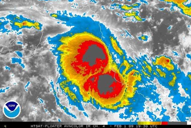
TROPICAL CYCLONE (TC) 12P (ELLIE), LOCATED APPROXIMATELY 85 NM SOUTH
OF CAIRNS, AUSTRALIA HAS TRACKED SOUTHWESTWARD AT 07 KNOTS OVER THE
PAST 06 HOURS. ANIMATED INFRARED SATELLITE IMAGERY AND THE TOWNSVILLE
AND CAIRNS RADARS INDICATE THAT TC 12P MADE LANDFALL SOUTH OF CAIRNS
AT APPROXIMATELY 01/14Z AND HAS WEAKENED SLIGHTLY AND TRACKED FURTHER
INLAND OVER THE PAST 06 HOURS. THE LOW-LEVEL CIRCULATION CENTER IS
CLEARLY DISCERNIBLE WITH BANDING REMAINING OVER THE NORTHERN AND
NORTHEASTERN QUADRANT AND STRONG INFLOW OVER THE SOUTHEASTERN FLANK.
THE MAJORITY OF THE SURFACE OBSERVATIONS SUPPORT THE CURRENT
INTENSITY OF 30 KNOTS, HOWEVER, COASTAL OBSERVATIONS FROM LUCINDA,
SOUTHEAST OF THE CENTER, REMAIN STRONGER AT 30-35 KNOTS SUSTAINED.
TC 12P IS EXPECTED TO TRACK SLOWLY WESTWARD TO NORTHWESTWARD THROUGH
TAU 12 BUT SHOULD WEAKEN WITH THE REMNANTS LIKELY TO TRACK BACK OVER
WATER IN A GENERAL EASTWARD DIRECTION. THERE IS A POSSIBILITY THAT
THE SYSTEM MAY REGENERATE AFTER 24-36 HOURS WITH BOTH THE GFS AND
ECMWF INDICATING 35 KNOT WINDS AFTER TAU 48. THIS IS THE FINAL
WARNING ON THIS SYSTEM BY THE JOINT TYPHOON WARNING
CENTER (NAVMARFCSTCEN). THE SYSTEM WILL BE CLOSELY MONITORED FOR
SIGNS OF REGENERATION. MAXIMUM SIGNIFICANT WAVE HEIGHT AT 011800Z
IS 10 FEET.//
NNNN
SUBJ: TROPICAL CYCLONE 12P (ELLIE) WARNING NR 003
1. TROPICAL CYCLONE 12P (ELLIE) WARNING NR 003
01 ACTIVE TROPICAL CYCLONE IN SOUTHPAC
MAX SUSTAINED WINDS BASED ON ONE-MINUTE AVERAGE
---
WARNING POSITION:
011800Z --- NEAR 18.3S 145.7E
MOVEMENT PAST SIX HOURS - 235 DEGREES AT 07 KTS
POSITION ACCURATE TO WITHIN 060 NM
POSITION BASED ON CENTER LOCATED BY SATELLITE
PRESENT WIND DISTRIBUTION:
MAX SUSTAINED WINDS - 030 KT, GUSTS 040 KT
WIND RADII VALID OVER OPEN WATER ONLY
DISSIPATING AS A SIGNIFICANT TROPICAL CYCLONE OVER LAND
REPEAT POSIT: 18.3S 145.7E
---
FORECASTS:
12 HRS, VALID AT:
020600Z --- 18.1S 145.6E
MAX SUSTAINED WINDS - 030 KT, GUSTS 040 KT
WIND RADII VALID OVER OPEN WATER ONLY
DISSIPATED AS A SIGNIFICANT TROPICAL CYCLONE OVER LAND
VECTOR TO 24 HR POSIT: 060 DEG/ 01 KTS
---
24 HRS, VALID AT:
021800Z --- 18.0S 145.8E
MAX SUSTAINED WINDS - 025 KT, GUSTS 035 KT
WIND RADII VALID OVER OPEN WATER ONLY
DISSIPATED AS A SIGNIFICANT TROPICAL CYCLONE OVER LAND
VECTOR TO 36 HR POSIT: 075 DEG/ 02 KTS
---
36 HRS, VALID AT:
030600Z --- 17.9S 146.2E
MAX SUSTAINED WINDS - 025 KT, GUSTS 035 KT
WIND RADII VALID OVER OPEN WATER ONLY
DISSIPATED AS A SIGNIFICANT TROPICAL CYCLONE OVER WATER
VECTOR TO 48 HR POSIT: 090 DEG/ 02 KTS
---
EXTENDED OUTLOOK:
48 HRS, VALID AT:
031800Z --- 17.9S 146.7E
MAX SUSTAINED WINDS - 025 KT, GUSTS 035 KT
WIND RADII VALID OVER OPEN WATER ONLY
DISSIPATED AS A SIGNIFICANT TROPICAL CYCLONE OVER WATER
---
REMARKS:
012100Z POSITION NEAR 18.3S 145.7E.
TROPICAL CYCLONE (TC) 12P (ELLIE), LOCATED APPROXIMATELY 85 NM SOUTH
OF CAIRNS, AUSTRALIA HAS TRACKED SOUTHWESTWARD AT 07 KNOTS OVER THE
PAST 06 HOURS. ANIMATED INFRARED SATELLITE IMAGERY AND THE TOWNSVILLE
AND CAIRNS RADARS INDICATE THAT TC 12P MADE LANDFALL SOUTH OF CAIRNS
AT APPROXIMATELY 01/14Z AND HAS WEAKENED SLIGHTLY AND TRACKED FURTHER
INLAND OVER THE PAST 06 HOURS. THE LOW-LEVEL CIRCULATION CENTER IS
CLEARLY DISCERNIBLE WITH BANDING REMAINING OVER THE NORTHERN AND
NORTHEASTERN QUADRANT AND STRONG INFLOW OVER THE SOUTHEASTERN FLANK.
THE MAJORITY OF THE SURFACE OBSERVATIONS SUPPORT THE CURRENT
INTENSITY OF 30 KNOTS, HOWEVER, COASTAL OBSERVATIONS FROM LUCINDA,
SOUTHEAST OF THE CENTER, REMAIN STRONGER AT 30-35 KNOTS SUSTAINED.
TC 12P IS EXPECTED TO TRACK SLOWLY WESTWARD TO NORTHWESTWARD THROUGH
TAU 12 BUT SHOULD WEAKEN WITH THE REMNANTS LIKELY TO TRACK BACK OVER
WATER IN A GENERAL EASTWARD DIRECTION. THERE IS A POSSIBILITY THAT
THE SYSTEM MAY REGENERATE AFTER 24-36 HOURS WITH BOTH THE GFS AND
ECMWF INDICATING 35 KNOT WINDS AFTER TAU 48. THIS IS THE FINAL
WARNING ON THIS SYSTEM BY THE JOINT TYPHOON WARNING
CENTER (NAVMARFCSTCEN). THE SYSTEM WILL BE CLOSELY MONITORED FOR
SIGNS OF REGENERATION. MAXIMUM SIGNIFICANT WAVE HEIGHT AT 011800Z
IS 10 FEET.//
NNNN
0 likes


Australian Government Bureau of Meteorology
Queensland
Coastal Waters Wind Warning
For Townsville to St Lawrence
Issued at 10:00 pm EST on Monday 2 February 2009
Synoptic Situation
Ex-Tropical Cyclone Ellie has moved inland west of Ingham and weakened. A ridge of higher pressure occurs along the east coast.
Strong Wind Warning
Townsville to St. Lawrence
SE/E winds 25/33 knots. Seas and swells to 3 metres.
Winds expected to ease below 26 knots by late Tuesday.
The next warning will be issued by 5 am AEST.
Please be aware
Wind gusts can be a further 40 percent stronger than the averages given here, and maximum waves may be up to twice the height.
0 likes
Who is online
Users browsing this forum: No registered users and 102 guests