Australia: ELLIE - Ex. TC : Landfall near Mission Beach

Moderator: S2k Moderators

Message
Author
User avatar
wyq614
Category 3
Category 3
Posts: 827
Age: 35
Joined: Sun Dec 02, 2007 12:32 am
Location: Beijing, China (Hometown: Qingdao, China, 36.06N 120.43E)
Contact:

Australia: ELLIE - Ex. TC : Landfall near Mission Beach

#1 Postby wyq614 » Fri Jan 30, 2009 3:41 pm

Image

ABPW10 PGTW 302000
MSGID/GENADMIN/NAVMARFCSTCEN PEARL HARBOR HI/JTWC//
SUBJ/SIGNIFICANT TROPICAL WEATHER ADVISORY FOR THE WESTERN AND
/SOUTH PACIFIC OCEANS REISSUED/302000Z-310600ZJAN2009//
RMKS/
1. WESTERN NORTH PACIFIC AREA (180 TO MALAY PENINSULA):
A. TROPICAL CYCLONE SUMMARY: NONE.
B. TROPICAL DISTURBANCE SUMMARY: NONE.
2. SOUTH PACIFIC AREA (WEST COAST OF SOUTH AMERICA TO 135 EAST):
A. TROPICAL CYCLONE SUMMARY: NONE.
B. TROPICAL DISTURBANCE SUMMARY:
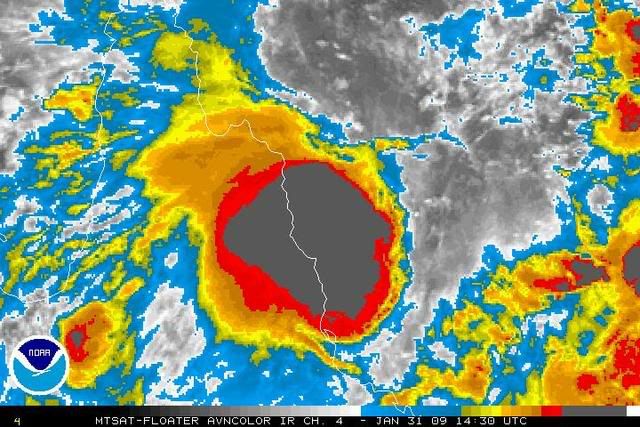
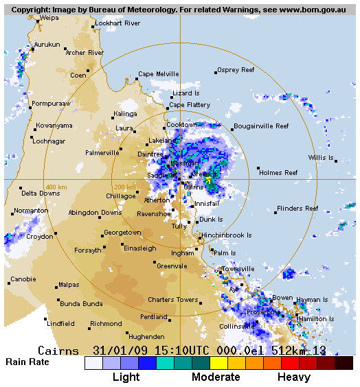
(1) AN AREA OF CONVECTION HAS PERSISTED NEAR 16.2S 146.5E,
APPROXIMATELY 60 NM NORTHEAST OF CAIRNS, AUSTRALIA. ANIMATED
INFRARED SATELLITE IMAGERY DEPICTS A DEVELOPING LOW-LEVEL
CIRCULATION CENTER (LLCC) WITH DEEP CONVECTION LOCATED, PRIMARILY,
OVER THE WESTERN SEMI-CIRCLE. A 301445Z TMI 37 GHZ IMAGE AS WELL AS
RADAR IMAGERY FROM THE CAIRNS RADAR SHOW A DEFINED LLCC WITH
FORMATIVE BANDING, ESPECIALLY OVER THE SOUTHWEST QUADRANT. SURFACE
OBSERVATIONS FROM HOLMES REEF, BOUGAINVILLE REEF AND GREEN ISLAND
SUPPORT A 20-25 KNOT SYSTEM WITH SLP AS LOW AS 998MB AND 24-HOUR SLP
FALLS OF 3-4 MB. REPORTS FROM GREEN ISLAND INDICATE SUSTAINED WINDS
OF 35-40 KNOTS, ENHANCED BY TOPOGRAPHY AND THE STRONG GRADIENT WITH
A HIGH TO THE SOUTH. OVERALL, THE ENVIRONMENT IS FAVORABLE FOR
FURTHER DEVELOPMENT WITH THE LLCC LOCATED UNDER WEAK VERTICAL WIND
SHEAR AND UNDER THE UPPER-LEVEL SUBTROPICAL RIDGE. MAXIMUM SUSTAINED
SURFACE WINDS ARE ESTIMATED AT 20 TO 25 KNOTS. MINIMUM SEA LEVEL
PRESSURE IS ESTIMATED TO BE NEAR 998 MB. THE POTENTIAL FOR THE
DEVELOPMENT OF A SIGNIFICANT TROPICAL CYCLONE WITHIN THE NEXT 24
HOURS IS FAIR.

(2) NO OTHER SUSPECT AREAS.
3. JUSTIFICATION FOR REISSUE: ADDED FAIR AREA IN PARA. 2.B.(1).
FORECAST TEAM: CHARLIE//
NNNN
0 likes   

User avatar
HURAKAN
Professional-Met
Professional-Met
Posts: 46086
Age: 37
Joined: Thu May 20, 2004 4:34 pm
Location: Key West, FL
Contact:

#2 Postby HURAKAN » Fri Jan 30, 2009 3:42 pm

Australian Government Bureau of Meteorology
Queensland
Tropical Cyclone Warning Centre

Media: This message is issued daily for the information of interested parties.
Media are NOT required to broadcast this message.

TROPICAL CYCLONE OUTLOOK
for the Coral Sea West of Longitude 160 East
Issued at 3:17pm on Friday the 30th of January 2009

At the present time, a weak tropical low will occur off the NE tropical coast
over the next few days but will weaken on Monday.

Tropical Cyclone outlooks issued by Brisbane can be accessed through the
Bureau's Home Page http://www.bom.gov.au.

Please note that the Darwin Regional Forecasting Centre issues Tropical
Cyclone Outlooks that cover the Gulf of Carpentaria. See
http:/www.bom.gov.au/weather/nt/cyclone/ or to subscribe to this service
call Darwin 08 8920 3820.
0 likes   

User avatar
wyq614
Category 3
Category 3
Posts: 827
Age: 35
Joined: Sun Dec 02, 2007 12:32 am
Location: Beijing, China (Hometown: Qingdao, China, 36.06N 120.43E)
Contact:

#3 Postby wyq614 » Fri Jan 30, 2009 3:51 pm

I think this time Australia may be wrong, what's more, Australia did underestimate the developing speed of Dominic-to-be.
0 likes   

User avatar
HURAKAN
Professional-Met
Professional-Met
Posts: 46086
Age: 37
Joined: Thu May 20, 2004 4:34 pm
Location: Key West, FL
Contact:

#4 Postby HURAKAN » Fri Jan 30, 2009 7:11 pm

Image

Image
0 likes   

User avatar
wyq614
Category 3
Category 3
Posts: 827
Age: 35
Joined: Sun Dec 02, 2007 12:32 am
Location: Beijing, China (Hometown: Qingdao, China, 36.06N 120.43E)
Contact:

#5 Postby wyq614 » Fri Jan 30, 2009 11:49 pm

TROPICAL CYCLONE OUTLOOK
for the Coral Sea West of Longitude 160 East
Issued at 2:39pm on Saturday the 31st of January 2009

At 1pm Saturday, a vigorous monsoon trough extended across the Coral Sea with a
996 hPa tropical low located near 15.9S 147.9E [approximately 250km northeast of
Cairns]. The low has intensified during the last 24 hours. It is expected to
remain slow moving during the next 24-48 hours while remaining offshore. It will
be located off the coast between Cairns and Cardwell on Monday morning.

The probability of tropical cyclone development during the next three days is:

Sunday: Medium
Monday: Low
Tuesday: Low


I intended to find out why the Australians think it will weaken on Monday, but failed. Don't know what's in their mind...
0 likes   

User avatar
Crostorm
Category 5
Category 5
Posts: 2060
Age: 49
Joined: Mon Dec 25, 2006 3:51 pm
Location: Croatia-Europe
Contact:

Re: Coral Sea: Invest 92P - Discussion JTWC:Fair

#6 Postby Crostorm » Sat Jan 31, 2009 12:13 am

Image

Image
0 likes   

User avatar
HURAKAN
Professional-Met
Professional-Met
Posts: 46086
Age: 37
Joined: Thu May 20, 2004 4:34 pm
Location: Key West, FL
Contact:

#7 Postby HURAKAN » Sat Jan 31, 2009 1:56 am

Australian Government Bureau of Meteorology
Queensland
Tropical Cyclone Warning Centre

Media: This message is issued daily for the information of interested parties.
Media are NOT required to broadcast this message.

TROPICAL CYCLONE OUTLOOK
for the Coral Sea West of Longitude 160 East
Issued at 2:39pm on Saturday the 31st of January 2009

At 1pm Saturday, a vigorous monsoon trough extended across the Coral Sea with a
996 hPa tropical low located near 15.9S 147.9E [approximately 250km northeast of
Cairns]. The low has intensified during the last 24 hours. It is expected to
remain slow moving during the next 24-48 hours while remaining offshore. It will
be located off the coast between Cairns and Cardwell on Monday morning.

The probability of tropical cyclone development during the next three days is:

Sunday: Medium
Monday: Low
Tuesday: Low

Tropical Cyclone outlooks issued by Brisbane can be accessed through the
Bureau's Home Page http://www.bom.gov.au.

Please note that the Darwin Regional Forecasting Centre issues Tropical
Cyclone Outlooks that cover the Gulf of Carpentaria. See
http:/www.bom.gov.au/weather/nt/cyclone/ or to subscribe to this service
call Darwin 08 8920 3820.
0 likes   

User avatar
Crostorm
Category 5
Category 5
Posts: 2060
Age: 49
Joined: Mon Dec 25, 2006 3:51 pm
Location: Croatia-Europe
Contact:

Re: Coral Sea: Invest 92P - Discussion JTWC:Fair

#8 Postby Crostorm » Sat Jan 31, 2009 5:34 am

B. TROPICAL DISTURBANCE SUMMARY:
(1) THE AREA OF CONVECTION PREVIOUSLY LOCATED NEAR 16.2S
146.5E, APPROXIMATELY 60 NM NORTHEAST OF CAIRNS, AUSTRALIA HAS
REMAINED QUASI-STATIONARY OVER THE PAST 06 HOURS. ANIMATED
MULTISPECTRAL IMAGERY DEPICTS A PARTIALLY EXPOSED LOW-LEVEL
CIRCULATION CENTER (LLCC) WITH DEEP CONVECTION LOCATED PRIMARILY
OVER THE WESTERN SEMI-CIRCLE. A 302129Z SSMI IMAGE AS WELL AS RADAR
IMAGERY FROM THE CAIRNS RADAR SHOW A DEFINED LLCC WITH FORMATIVE
BANDING, ESPECIALLY OVER THE SOUTHWEST QUADRANT. SURFACE
OBSERVATIONS IN THE REGION SUPPORT A 20-25 KNOT DISTURBANCE WITH SLP
AS LOW AS 998MB. OVERALL, THE ENVIRONMENT REMAINS FAVORABLE FOR
FURTHER DEVELOPMENT WITH THE LLCC LOCATED UNDER WEAK VERTICAL WIND
SHEAR AND UNDER THE UPPER-LEVEL SUBTROPICAL RIDGE. MAXIMUM SUSTAINED
SURFACE WINDS ARE ESTIMATED AT 20 TO 25 KNOTS. MINIMUM SEA LEVEL
PRESSURE IS ESTIMATED TO BE NEAR 998 MB. THE POTENTIAL FOR THE
DEVELOPMENT OF A SIGNIFICANT TROPICAL CYCLONE WITHIN THE NEXT 24
HOURS REMAINS FAIR.
0 likes   

User avatar
Crostorm
Category 5
Category 5
Posts: 2060
Age: 49
Joined: Mon Dec 25, 2006 3:51 pm
Location: Croatia-Europe
Contact:

Re: Coral Sea: Invest 92P - Discussion JTWC:Fair

#9 Postby Crostorm » Sat Jan 31, 2009 5:37 am

Image
0 likes   

User avatar
Crostorm
Category 5
Category 5
Posts: 2060
Age: 49
Joined: Mon Dec 25, 2006 3:51 pm
Location: Croatia-Europe
Contact:

Re: Coral Sea: Invest 92P - Discussion JTWC:Fair

#10 Postby Crostorm » Sat Jan 31, 2009 5:44 am

0 likes   

User avatar
HURAKAN
Professional-Met
Professional-Met
Posts: 46086
Age: 37
Joined: Thu May 20, 2004 4:34 pm
Location: Key West, FL
Contact:

#11 Postby HURAKAN » Sat Jan 31, 2009 10:09 am

Image
0 likes   

User avatar
HURAKAN
Professional-Met
Professional-Met
Posts: 46086
Age: 37
Joined: Thu May 20, 2004 4:34 pm
Location: Key West, FL
Contact:

#12 Postby HURAKAN » Sat Jan 31, 2009 10:21 am

Image

Image
0 likes   

User avatar
P.K.
Professional-Met
Professional-Met
Posts: 5149
Joined: Thu Sep 23, 2004 5:57 pm
Location: Watford, England
Contact:

Re: Coral Sea: Invest 92P - Discussion JTWC:Fair

#13 Postby P.K. » Sat Jan 31, 2009 1:34 pm

AXAU21 ABRF 311804
IDQ20018
TROPICAL CYCLONE TECHNICAL BULLETIN: AUSTRALIA - EASTERN REGION
Issued by BRISBANE TROPICAL CYCLONE WARNING CENTRE
at: 1804 UTC 31/01/2009
Name: Tropical Cyclone Ellie
Data At: 1700 UTC
Latitude: 17.0S
Longitude: 147.4E
Location Accuracy: within 30 nm [55 km]
Movement Towards: south [187 deg]
Speed of Movement: 4 knots [8 km/h]
Maximum 10-Minute Wind: 40 knots [75 km/h]
Maximum 3-Second Wind Gust: 55 knots [100 km/h]
Central Pressure: 990 hPa
Radius of 34-knot winds NE quadrant: 60 nm [110 km]
Radius of 34-knot winds SE quadrant: 60 nm [110 km]
Radius of 34-knot winds SW quadrant: 60 nm [110 km]
Radius of 34-knot winds NW quadrant: 60 nm [110 km]
Radius of 48-knot winds NE quadrant:
Radius of 48-knot winds SE quadrant:
Radius of 48-knot winds SW quadrant:
Radius of 48-knot winds NW quadrant:
Radius of 64-knot winds:
Radius of Maximum Winds: 30 nm [55 km]
Dvorak Intensity Code: T3.0/3.0/D1.0/8HRS
Pressure of outermost isobar: 1000 hPa
Radius of outermost closed isobar: 90 nm [165 km]
Storm Depth: Medium
FORECAST DATA
Date/Time : Location : Loc. Accuracy: Max Wind : Central Pressure
[UTC] : degrees : nm [km]: knots[km/h]: hPa
+12: 01/0500: 17.8S 146.8E: 035 [065]: 040 [075]: 987
+24: 01/1700: 18.4S 146.3E: 040 [075]: 040 [075]: 987
+36: 02/0500: 18.8S 145.9E: 050 [095]: 030 [055]: 993
+48: 02/1700: 18.9S 145.4E: 060 [110]: 025 [045]: 995
+60: 03/0500: 18.3S 145.7E: 200 [375]: 015 [030]: 996
+72: 03/1700: 17.6S 146.9E: 250 [465]: 020 [035]: 996
REMARKS:
Shear pattern

Copyright Commonwealth of Australia
==
The next bulletin for this system will be issued by: 01/0100 UTC by Brisbane
TCWC.

Image
0 likes   

User avatar
HURAKAN
Professional-Met
Professional-Met
Posts: 46086
Age: 37
Joined: Thu May 20, 2004 4:34 pm
Location: Key West, FL
Contact:

#14 Postby HURAKAN » Sat Jan 31, 2009 3:46 pm

I guess BOM said oops!!
0 likes   

User avatar
HURAKAN
Professional-Met
Professional-Met
Posts: 46086
Age: 37
Joined: Thu May 20, 2004 4:34 pm
Location: Key West, FL
Contact:

#15 Postby HURAKAN » Sat Jan 31, 2009 4:07 pm

Australian Government Bureau of Meteorology
Queensland
Tropical Cyclone Warning Centre

Media: The Standard Emergency Warning Signal should NOT be used with this
warning.

TOP PRIORITY
TROPICAL CYCLONE ADVICE NUMBER 2
Issued by the Bureau of Meteorology, Brisbane
Issued at 6:54am on Sunday the 1st of February 2009

A Cyclone WARNING remains current for coastal and island communities from Cairns
to Ayr.

At 6:00 am EST Tropical Cyclone Ellie, Category 1 was estimated to be
165 kilometres east of Cairns and 205 kilometres northeast of Cardwell and
moving slowly southwest towards the coast.

TROPICAL CYCLONE ELLIE, CATEGORY 1, with gusts up to 100 km/h may be close to
the coast by Monday morning.

STRONG GALES may develop on the coast during this afternoon between Cairns and
Ayr.

Higher than normal tides are expected, but the sea level should not exceed the
highest tide of the year. Large waves are likely along the beachfront.

Flooding is likely in the warning area due to heavy rain.

Details of Tropical Cyclone Ellie at 6:00 am EST:
.Centre located near...... 17.2 degrees South 147.3 degrees East
.Location accuracy........ within 55 kilometres
.Recent movement.......... towards the southwest at 9 kilometres per hour
.Wind gusts near centre... 100 kilometres per hour
.Severity category........ 1
.Central pressure......... 990 hectoPascals

The next advice will be issued by 10:00 am EST Sunday 01 February.

This warning is also available through TV and Radio Broadcasts; the Bureau's
website at http://www.bom.gov.au or call 1300 659 212. The Bureau and the State
Emergency Service would appreciate this warning being broadcast regularly.
0 likes   

User avatar
HURAKAN
Professional-Met
Professional-Met
Posts: 46086
Age: 37
Joined: Thu May 20, 2004 4:34 pm
Location: Key West, FL
Contact:

#16 Postby HURAKAN » Sat Jan 31, 2009 4:10 pm

Image

SUBJ: TROPICAL CYCLONE 12P (ELLIE) WARNING NR 001
WTPS31 PGTW 312100
1. TROPICAL CYCLONE 12P (ELLIE) WARNING NR 001
01 ACTIVE TROPICAL CYCLONE IN SOUTHPAC
MAX SUSTAINED WINDS BASED ON ONE-MINUTE AVERAGE
---
WARNING POSITION:
311800Z --- NEAR 16.7S 147.5E
MOVEMENT PAST SIX HOURS - 255 DEGREES AT 04 KTS
POSITION ACCURATE TO WITHIN 060 NM
POSITION BASED ON CENTER LOCATED BY SATELLITE
PRESENT WIND DISTRIBUTION:
MAX SUSTAINED WINDS - 040 KT, GUSTS 050 KT
WIND RADII VALID OVER OPEN WATER ONLY
RADIUS OF 034 KT WINDS - 050 NM NORTHEAST QUADRANT
065 NM SOUTHEAST QUADRANT
065 NM SOUTHWEST QUADRANT
050 NM NORTHWEST QUADRANT
REPEAT POSIT: 16.7S 147.5E
---
FORECASTS:
12 HRS, VALID AT:
010600Z --- 17.2S 147.0E
MAX SUSTAINED WINDS - 040 KT, GUSTS 050 KT
WIND RADII VALID OVER OPEN WATER ONLY
RADIUS OF 034 KT WINDS - 050 NM NORTHEAST QUADRANT
065 NM SOUTHEAST QUADRANT
065 NM SOUTHWEST QUADRANT
050 NM NORTHWEST QUADRANT
VECTOR TO 24 HR POSIT: 215 DEG/ 03 KTS
---
24 HRS, VALID AT:
011800Z --- 17.7S 146.6E
MAX SUSTAINED WINDS - 040 KT, GUSTS 050 KT
WIND RADII VALID OVER OPEN WATER ONLY
RADIUS OF 034 KT WINDS - 050 NM NORTHEAST QUADRANT
065 NM SOUTHEAST QUADRANT
065 NM SOUTHWEST QUADRANT
050 NM NORTHWEST QUADRANT
VECTOR TO 36 HR POSIT: 220 DEG/ 04 KTS
---
36 HRS, VALID AT:
020600Z --- 18.3S 146.1E
MAX SUSTAINED WINDS - 035 KT, GUSTS 045 KT
WIND RADII VALID OVER OPEN WATER ONLY
DISSIPATING AS A SIGNIFICANT TROPICAL CYCLONE OVER WATER
VECTOR TO 48 HR POSIT: 200 DEG/ 02 KTS
---
EXTENDED OUTLOOK:
48 HRS, VALID AT:
021800Z --- 18.6S 146.0E
MAX SUSTAINED WINDS - 030 KT, GUSTS 040 KT
WIND RADII VALID OVER OPEN WATER ONLY
DISSIPATED AS A SIGNIFICANT TROPICAL CYCLONE OVER LAND
---
REMARKS:
312100Z POSITION NEAR 16.8S 147.4E.
MAXIMUM SIGNIFICANT WAVE HEIGHT AT 311800Z IS 11 FEET.
NEXT WARNINGS AT 010900Z AND 012100Z.
0 likes   

User avatar
HURAKAN
Professional-Met
Professional-Met
Posts: 46086
Age: 37
Joined: Thu May 20, 2004 4:34 pm
Location: Key West, FL
Contact:

#17 Postby HURAKAN » Sat Jan 31, 2009 4:33 pm

Image

Image
0 likes   

User avatar
HURAKAN
Professional-Met
Professional-Met
Posts: 46086
Age: 37
Joined: Thu May 20, 2004 4:34 pm
Location: Key West, FL
Contact:

#18 Postby HURAKAN » Sat Jan 31, 2009 7:18 pm

Australian Government Bureau of Meteorology
Queensland
Tropical Cyclone Warning Centre

Media: The Standard Emergency Warning Signal should NOT be used with this
warning.

TOP PRIORITY
TROPICAL CYCLONE ADVICE NUMBER 3
Issued by the Bureau of Meteorology, Brisbane
Issued at 9:48am on Sunday the 1st of February 2009

A Cyclone WARNING is current for coastal and island communities from Cairns to
Ayr.

At 9:00 am EST Tropical Cyclone Ellie, Category 1 was estimated to be
150 kilometres east of Cairns and 205 kilometres northeast of Cardwell and
moving slowly southwest towards the coast.

TROPICAL CYCLONE Ellie, CATEGORY 1, with gusts up to 100 km/h may be close to
the coast on Monday morning.

STRONG GALES may develop on the coast during this evening between Cairns and
Ayr.

Higher than normal tides are expected, but the sea level should not exceed the
highest tide of the year. Large waves are likely along the beachfront.

Flooding is likely to continue in the warning area due to heavy rain.

Details of Tropical Cyclone Ellie at 9:00 am EST
.Centre located near...... 16.9 degrees South 147.2 degrees East
.Location accuracy........ within 55 kilometres
.Recent movement.......... towards the southwest at 4 kilometres per hour
.Wind gusts near centre... 100 kilometres per hour
.Severity category........ 1
.Central pressure......... 990 hectoPascals

The next advice will be issued by 1:00 pm EST Sunday 01 February.

This warning is also available through TV and Radio Broadcasts; the Bureau's
website at http://www.bom.gov.au or call 1300 659 212. The Bureau and the State
Emergency Service would appreciate this warning being broadcast regularly.
0 likes   

User avatar
HURAKAN
Professional-Met
Professional-Met
Posts: 46086
Age: 37
Joined: Thu May 20, 2004 4:34 pm
Location: Key West, FL
Contact:

Re: Coral Sea: ELLIE - Tropical Cyclone = Discussion

#19 Postby HURAKAN » Sat Jan 31, 2009 7:20 pm

Image

Image
0 likes   

User avatar
HURAKAN
Professional-Met
Professional-Met
Posts: 46086
Age: 37
Joined: Thu May 20, 2004 4:34 pm
Location: Key West, FL
Contact:

#20 Postby HURAKAN » Sun Feb 01, 2009 6:03 am

Australian Government Bureau of Meteorology
Queensland
Tropical Cyclone Warning Centre

Media: The Standard Emergency Warning Signal should NOT be used with this
warning.

TOP PRIORITY
TROPICAL CYCLONE ADVICE NUMBER 6
Issued by the Bureau of Meteorology, Brisbane
Issued at 8:05pm on Sunday the 1st of February 2009

A Cyclone WARNING remains current for coastal and island communities from Cairns
to Ayr.

At 7:00 pm EST Tropical Cyclone Ellie, Category 1 was estimated to be 130
kilometres southeast of Cairns and 80 kilometres northeast of Cardwell moving
southwest at 12 kilometres per hour towards the coast.

Tropical Cyclone Ellie is expected to continue to approach the coast overnight
tonight and cross the coast between Cardwell and Ingham on Monday morning.

GALES are expected to develop about the exposed coast and islands overnight
between Cairns and Ayr.

Higher than normal tides are expected, but the sea level should not exceed the
highest tide of the year. Large waves are likely along the beachfront.

Flooding is likely to continue in the warning area due to heavy rain.

Details of Tropical Cyclone Ellie at 7:00 pm EST
.Centre located near...... 17.8 degrees South 146.6 degrees East
.Location accuracy........ within 55 kilometres
.Recent movement.......... towards the southwest at 12 kilometres per hour
.Wind gusts near centre... 100 kilometres per hour
.Severity category........ 1
.Central pressure......... 991 hectoPascals

People between Cairns and Ayr should take precautions and listen to the next
advice at 11pm. If you are unsure about precautions to be taken, information is
available from your local government or local State Emergency Service.

The next advice will be issued by 11:00 pm EST Sunday 01 February.

This warning is also available through TV and Radio Broadcasts; the Bureau's
website at http://www.bom.gov.au or call 1300 659 212. The Bureau and the State
Emergency Service would appreciate this warning being broadcast regularly.
0 likes   


Return to “2009”

Who is online

Users browsing this forum: No registered users and 102 guests