
WA: Tropical Low (Invest 95S)
Moderator: S2k Moderators
-
HURAKAN

- Professional-Met

- Posts: 46086
- Age: 37
- Joined: Thu May 20, 2004 4:34 pm
- Location: Key West, FL
- Contact:
Australian Government Bureau of Meteorology
Western Australia
Media: The Standard Emergency Warning Signal should NOT be used with this
warning.
TOP PRIORITY FOR IMMEDIATE BROADCAST
TROPICAL CYCLONE ADVICE NUMBER 8
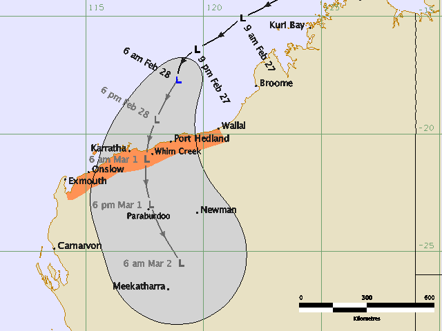
Issued at 3:45 am WDT on Saturday, 28 February 2009
BY THE BUREAU OF METEOROLOGY
TROPICAL CYCLONE WARNING CENTRE PERTH
A Cyclone WARNING is current for coastal areas from Wallal to Exmouth.
At 3:00 am WDT a Tropical Low was estimated to be
360 kilometres north of Port Hedland and
465 kilometres north northeast of Karratha and
moving southwest at 18 kilometres per hour.
Widespread heavy rain is likely in the Pilbara during today as the system
approaches the Pilbara coast, and significant flooding may result. Please refer
to Flood Watch advices for more information.
The low remains weak but there is a chance it could develop into a tropical
cyclone prior to making landfall. If the system does intensify into a tropical
cyclone GALES may develop in coastal areas late today or early Sunday.
Details of Tropical Low at 3:00 am WDT:
.Centre located near...... 17.1 degrees South 119.0 degrees East
.Location accuracy........ within 110 kilometres
.Recent movement.......... towards the southwest at 18 kilometres per hour
.Wind gusts near centre... 85 kilometres per hour
.Severity category........ below cyclone intensity
.Central pressure......... 998 hectoPascals
FESA-State Emergency Service advises that there are no community alerts at
present.
Communities between Exmouth and Wallal should listen for the next advice.
The next advice will be issued by 7:00 am WDT Saturday 28 February.
Cyclone advices and State Emergency Service Community Alerts are available by
dialling 1300 659 210
A map showing the track of the cyclone is available at:
http://www.bom.gov.au/weather/cyclone
Western Australia
Media: The Standard Emergency Warning Signal should NOT be used with this
warning.
TOP PRIORITY FOR IMMEDIATE BROADCAST
TROPICAL CYCLONE ADVICE NUMBER 8
Issued at 3:45 am WDT on Saturday, 28 February 2009
BY THE BUREAU OF METEOROLOGY
TROPICAL CYCLONE WARNING CENTRE PERTH
A Cyclone WARNING is current for coastal areas from Wallal to Exmouth.
At 3:00 am WDT a Tropical Low was estimated to be
360 kilometres north of Port Hedland and
465 kilometres north northeast of Karratha and
moving southwest at 18 kilometres per hour.
Widespread heavy rain is likely in the Pilbara during today as the system
approaches the Pilbara coast, and significant flooding may result. Please refer
to Flood Watch advices for more information.
The low remains weak but there is a chance it could develop into a tropical
cyclone prior to making landfall. If the system does intensify into a tropical
cyclone GALES may develop in coastal areas late today or early Sunday.
Details of Tropical Low at 3:00 am WDT:
.Centre located near...... 17.1 degrees South 119.0 degrees East
.Location accuracy........ within 110 kilometres
.Recent movement.......... towards the southwest at 18 kilometres per hour
.Wind gusts near centre... 85 kilometres per hour
.Severity category........ below cyclone intensity
.Central pressure......... 998 hectoPascals
FESA-State Emergency Service advises that there are no community alerts at
present.
Communities between Exmouth and Wallal should listen for the next advice.
The next advice will be issued by 7:00 am WDT Saturday 28 February.
Cyclone advices and State Emergency Service Community Alerts are available by
dialling 1300 659 210
A map showing the track of the cyclone is available at:
http://www.bom.gov.au/weather/cyclone
0 likes
-
cycloneye

- Admin

- Posts: 139067
- Age: 67
- Joined: Thu Oct 10, 2002 10:54 am
- Location: San Juan, Puerto Rico
Re: WA: Tropical Low (Invest 95S)
ABIO10 PGTW 271800
MSGID/GENADMIN/NAVMARFCSTCEN PEARL HARBOR HI/JTWC//
SUBJ/SIGNIFICANT TROPICAL WEATHER ADVISORY FOR THE INDIAN OCEAN
/2701800Z-281800ZFEB2009//
RMKS/
1. NORTH INDIAN OCEAN AREA (MALAY PENINSULA WEST TO COAST OF AFRICA):
A. TROPICAL CYCLONE SUMMARY: NONE.
B. TROPICAL DISTURBANCE SUMMARY: NONE.
2. SOUTH INDIAN OCEAN AREA (135E WEST TO COAST OF AFRICA):
A. TROPICAL CYCLONE SUMMARY: NONE.
B. TROPICAL DISTURBANCE SUMMARY:
(1) THE AREA OF CONVECTION PREVIOUSLY LOCATED NEAR 17.5S
122.4E, IS NOW LOCATED NEAR 17.3S 119.4E, APPROXIMATELY 415 NM
NORTHEAST OF LEARMONTH, AUSTRALIA. ANIMATED INFRARED SATELLITE
IMAGERY INDICATES THAT THE LOW LEVEL CIRCULATION CENTER (LLCC)
THAT HAD PREVIOUSLY BEEN TRACKING OVER LAND HAS MOVED OVER
WATER. SEA SURFACE TEMPERATURES ARE VERY FAVORABLE FOR THE
LLCC TO CONTINUE TO DEVELOP AS IT TRACKS TO THE SOUTHWEST.
UPPER LEVEL ANALYSIS INDICATES LOW VERTICAL WIND SHEAR AND
GOOD OUTFLOW AS THE LLCC REMAINS JUST EQUATORWARD OF AN
UPPER LEVEL SUBTROPICAL RIDGE. MID-LEVEL RIDGING OVER AUSTRALIA
WILL BE THE DOMINANT STEERING INFLUENCE AS THE LLCC TRACKS
SOUTHWESTWARD. MAXIMUM SUSTAINED SURFACE WINDS ARE ESTIMATED
AT 25 TO 30 KNOTS. MINIMUM SEA LEVEL PRESSURE IS ESTIMATED TO BE
NEAR 1001 MB. SEE REF A (WTXS21 PGTW 270230) FOR FURTHER DETAILS.
SINCE THE LLCC HAS MOVED OVER WATER, REMAINS IN A FAVORABLE
ENVIRONMENT AND IS BEGINNING TO CONSOLIDATE, THE POTENTIAL
FOR THE DEVELOPMENT OF A SIGNIFICANT TROPICAL CYCLONE WITHIN
THE NEXT 24 HOURS REMAINS GOOD.
(2) NO OTHER SUSPECT AREAS.
FORECAST TEAM: CHARLIE//
NNNN
http://metocph.nmci.navy.mil/jtwc.php
0 likes
-
HURAKAN
- Professional-Met
- Posts: 46086
- Age: 37
- Joined: Thu May 20, 2004 4:34 pm
- Location: Key West, FL
- Contact:
Re: WA: Tropical Low (Invest 95S)
TROPICAL CYCLONE ADVICE NUMBER 9
Issued at 6:40 am WDT on Saturday, 28 February 2009
BY THE BUREAU OF METEOROLOGY
TROPICAL CYCLONE WARNING CENTRE PERTH
A Cyclone WARNING is current for coastal areas from Wallal to Exmouth.
At 6:00 am WDT a Tropical Low was estimated to be
295 kilometres north of Port Hedland and
400 kilometres north northeast of Karratha and
moving southwest at 18 kilometres per hour.
Widespread heavy rain is likely in the Pilbara during today as the system
approaches the Pilbara coast, and significant flooding may result. Please refer
to Flood Watch advices for more information.
The low remains weak but there is a chance it could develop into a tropical
cyclone prior to making landfall. If the system does intensify into a tropical
cyclone GALES may develop in coastal areas late today or early Sunday.
Details of Tropical Low at 6:00 am WDT:
.Centre located near...... 17.7 degrees South 118.9 degrees East
.Location accuracy........ within 110 kilometres
.Recent movement.......... towards the southwest at 18 kilometres per hour
.Wind gusts near centre... 85 kilometres per hour
.Severity category........ below cyclone intensity
.Central pressure......... 998 hectoPascals
FESA-State Emergency Service advises that there are no community alerts at
present.
Communities between Exmouth and Wallal should listen for the next advice.
The next advice will be issued by 10:00 am WDT Saturday 28 February.
Cyclone advices and State Emergency Service Community Alerts are available by
dialling 1300 659 210
A map showing the track of the cyclone is available at:
http://www.bom.gov.au/weather/cyclone
0 likes


-
HURAKAN
- Professional-Met
- Posts: 46086
- Age: 37
- Joined: Thu May 20, 2004 4:34 pm
- Location: Key West, FL
- Contact:
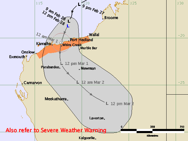
TROPICAL CYCLONE ADVICE NUMBER 10
Issued at 9:45 am WDT on Saturday, 28 February 2009
BY THE BUREAU OF METEOROLOGY
TROPICAL CYCLONE WARNING CENTRE PERTH
A Cyclone WARNING is current for coastal areas from Wallal to Onslow.
At 9:00 am WDT a Tropical Low was estimated to be
235 kilometres north of Port Hedland and
335 kilometres north northeast of Karratha and
moving south southwest at 18 kilometres per hour.
Widespread heavy rain is likely in the Pilbara during today as the system
approaches the Pilbara coast, and significant flooding may result. Please refer
to Flood Watch advices for more information.
The low remains weak but there is a chance it could develop into a tropical
cyclone prior to making landfall. If the system does intensify into a tropical
cyclone gales may develop in coastal areas late today.
Details of Tropical Low at 9:00 am WDT:
.Centre located near...... 18.2 degrees South 118.6 degrees East
.Location accuracy........ within 110 kilometres
.Recent movement.......... towards the south southwest at 18 kilometres per hour
.Wind gusts near centre... 85 kilometres per hour
.Severity category........ below cyclone intensity
.Central pressure......... 998 hectoPascals
FESA-State Emergency Service advises that there are no community alerts at
present.
Communities between Onslow and Wallal should listen for the next advice.
The next advice will be issued by 1:00 pm WDT Saturday 28 February.
Cyclone advices and State Emergency Service Community Alerts are available by
dialling 1300 659 210
A map showing the track of the cyclone is available at:
http://www.bom.gov.au/weather/cyclone
0 likes
-
Craiga74

- Tropical Low

- Posts: 42
- Age: 49
- Joined: Thu Feb 21, 2008 8:59 am
- Location: Port Hedland, Australia
- Contact:
Re: WA: Tropical Low (Invest 95S)
It appears from the radar loop that it has taken a more southerly track towards here...
http://radar.strikeone.net.au/?fuseaction=loops.main&radar=161&numberofImages=40&dateStart=0&dateFinish=0&decimalLatitude=&decimalLongitude=
Our could just be my wishful thinking
http://radar.strikeone.net.au/?fuseaction=loops.main&radar=161&numberofImages=40&dateStart=0&dateFinish=0&decimalLatitude=&decimalLongitude=
Our could just be my wishful thinking
0 likes

-
Grifforzer
- Category 1

- Posts: 418
- Joined: Thu Feb 26, 2009 11:27 pm
WTXS21 PGTW 280230
REF/A/NAVMARFCSTCEN PEARL HARBOR HI/270221Z FEB 09//
AMPN/REF A IS A TROPICAL CYCLONE FORMATION ALERT (WTXS21 PGTW
270230)//
RMKS/
1. FORMATION OF A SIGNIFICANT TROPICAL CYCLONE IS POSSIBLE
WITHIN 075 NM EITHER SIDE OF A LINE FROM 18.1S 118.7E TO 21.7S
117.3E WITHIN THE NEXT 06 TO 24 HOURS. AVAILABLE DATA DOES NOT
JUSTIFY ISSUANCE OF NUMBERED TROPICAL CYCLONE WARNINGS AT THIS TIME.
WINDS IN THE AREA ARE ESTIMATED TO BE 25 TO 30 KNOTS. METSAT
IMAGERY AT 272330Z INDICATES THAT A CIRCULATION CENTER IS LOCATED
NEAR 18.4S 118.6E. THE SYSTEM IS MOVING SOUTH-SOUTHWESTWARD AT
04 KNOTS.
2. REMARKS:THE AREA OF CONVECTION PREVIOUSLY LOCATED NEAR
17.5S 122.4E, IS NOW LOCATED NEAR 18.4S 118.6E, APPROXIMATELY
345 NM NORTHEAST OF LEARMONTH, AUSTRALIA. ANIMATED MULTI-
SPECTRAL SATELLITE IMAGERY INDICATES THAT THE LOW LEVEL
CIRCULATION CENTER (LLCC) THAT HAD PREVIOUSLY BEEN TRACKING
OVER LAND HAS NOW BEEN OVER WATER FOR THE PAST 12 HOURS.
SEA SURFACE TEMPERATURES ARE FAVORABLE FOR THE LLCC TO
CONTINUE TO SLOWLY DEVELOP, BUT THE CLOSE PROXIMITY TO LAND
HAS SOMEWHAT LIMITED DEVELOPMENT. UPPER LEVEL ANALYSIS
INDICATES LOW VERTICAL WIND SHEAR AND GOOD OULFLOW AS THE
LLCC IS JUST EQUATORWARD OF AN UPPER LEVEL SUBTROPICAL RIDGE.
MID-LEVEL RIDGING OVER AUSTRALIA WILL BE THE DOMINANT STEERING
INFLUENCE, TRACKING THE LLCC TOWARD THE SOUTHWEST AND THEN
SOUTH-SOUTHWEST. MAXIMUM SUSTAINED SURFACE WINDS ARE ESTIMATED
AT 25 TO 30 KNOTS. MINIMUM SEA LEVEL PRESSURE IS ESTIMATED TO
BE NEAR 1001 MB. SINCE THE OVERALL ENVIRONMENT WILL REMAIN
FAVORABLE, THE POTENTIAL FOR THE DEVELOPMENT OF A SIGNIFICANT
TROPICAL CYCLONE WITHIN THE NEXT 24 HOURS IS GOOD. THIS SUPERSEDES
REF A.
3. THIS ALERT WILL BE REISSUED, UPGRADED TO WARNING OR CANCELLED
BY 010230Z.////
0 likes
-
HURAKAN
- Professional-Met
- Posts: 46086
- Age: 37
- Joined: Thu May 20, 2004 4:34 pm
- Location: Key West, FL
- Contact:
TROPICAL CYCLONE ADVICE NUMBER 11
Issued at 12:50 pm WDT on Saturday, 28 February 2009
BY THE BUREAU OF METEOROLOGY
TROPICAL CYCLONE WARNING CENTRE PERTH
A Cyclone WARNING is current for coastal areas from Wallal to Onslow.
At midday WDT a tropical low was estimated to be
180 kilometres north of Port Hedland and
285 kilometres northeast of Karratha and
moving south southwest at 18 kilometres per hour.
Widespread heavy rain is likely in the Pilbara during today as the system
approaches the Pilbara coast, and significant flooding may result. Please refer
to Flood Watch advices for more information.
The low remains weak but there is a chance it could develop into a tropical
cyclone prior to making landfall. If the system does intensify into a tropical
cyclone gales may develop in coastal areas late today.
As the low moves inland, it may produce flash flooding and locally damaging
winds through the eastern Pilbara, northeast Gascoyne, northern Goldfields and
adjacent Interior. A separate Severe Weather Warning has been issued for these
areas [IDW28001].
Details of Tropical Low at midday WDT:
.Centre located near...... 18.7 degrees South 118.5 degrees East
.Location accuracy........ within 110 kilometres
.Recent movement.......... towards the south southwest at 18 kilometres per hour
.Wind gusts near centre... 85 kilometres per hour
.Severity category........ below cyclone intensity
.Central pressure......... 998 hectoPascals
FESA-State Emergency Service advises that there are no community alerts at
present.
Communities between Onslow and Wallal should listen for the next advice.
The next advice will be issued by 4:00 pm WDT Saturday 28 February.
Cyclone advices and State Emergency Service Community Alerts are available by
dialling 1300 659 210
A map showing the track of the cyclone is available at:
http://www.bom.gov.au/weather/cyclone
0 likes
-
Grifforzer
- Category 1
- Posts: 418
- Joined: Thu Feb 26, 2009 11:27 pm
Tropical Cyclone Warning Center Perth
Tropical Cyclone Advice Number TWELVE
3:50 pm WDT February 28 2009
===============================================
At 3:00 PM WDT, A TROPICAL LOW [997 hPa] located at 19.3S 118.5E, or 115 kms north of Port Hedland and 235 kms northeast of Karratha has 10 minute sustained winds of 30 knots with gusts of 45 knots. The tropical low is reported as moving towards the south at 10 knots.
Widespread heavy rain is likely in the Pilbara during today as the system approaches the Pilbara coast, and significant flooding may result. Please refer to Flood Watch advices for more information.
The low remains weak but there is a chance it could develop into a tropical cyclone prior to making landfall. If the system does intensify into a tropical cyclone gales may develop in coastal areas late today.
As the low moves inland, it may produce flash flooding and locally damaging winds through the eastern Pilbara, northeast Gascoyne, northern Goldfields and adjacent Interior. A separate Severe Weather Warning has been issued for these areas [IDW28001].
Tropical Cyclone Warning
=======================
A Cyclone WARNING is current for coastal areas from Wallal to Mardie.
The Cyclone Warning between Mardie and Onslow has been CANCELLED
Next Tropical Cyclone Advice is at 7:00 PM WDT..
0 likes
-
cycloneye
- Admin
- Posts: 139067
- Age: 67
- Joined: Thu Oct 10, 2002 10:54 am
- Location: San Juan, Puerto Rico
Re: WA: Tropical Low (Invest 95S)
WTXS21 PGTW 281130
SUBJ/TROPICAL CYCLONE FORMATION ALERT CANCELLATION//
REF/A/NAVMARFCSTCEN PEARL HARBOR HI/280221Z FEB 09//
AMPN/REF IS TROPICAL CYCLONE FORMATION ALERT (WTXS21 PGTW 280230)//
RMKS/
1. REMARKS: THIS CANCELS REF A. THE AREA OF CONVECTION PREVIOUSLY
LOCATED NEAR 18.4S 118.6E IS NOW LOCATED NEAR 20.4S 118.7E,
APPROXIMATELY 15 NM SOUTHEAST OF PORT HEDLAND, AUSTRALIA. ANIMATED
INFRARED SATELLITE IMAGERY AND RADAR DATA FROM PORT HEDLAND INDICATE
THAT THE SYSTEM MADE LANDFALL JUST EAST OF PORT HEDLAND NEAR 28/10Z
AND HAS CONTINUED TO TRACK SOUTHWARD AT 8-10 KNOTS. SURFACE OBSERVA-
TIONS INDICATE MINIMUM SLP NEAR 997 MB, HOWEVER, MAXIMUM SUSTAINED
SURFACE WINDS HAVE REMAINED BELOW 20 KNOTS AND ARE NOW 07-12 KNOTS.
OVERALL, THE SYSTEM FAILED TO CONSOLIDATE AND MAINTAINED WEAK BANDING
OVER THE SOUTHERN SEMI-CIRCLE. THE YPPD SOUNDING INDICATED 30-35 KNOT
GRADIENT WINDS AND A MOIST ATMOSPHERE BUT WITH MODERATE VERTICAL WIND
SHEAR. MAXIMUM SUSTAINED SURFACE WINDS ARE ESTIMATED AT 20-25 KNOTS.
MINIMUM SEA LEVEL PRESSURE IS ESTIMATED TO BE NEAR 997 MB. THE SYSTEM
IS EXPECTED TO CONTINUE TRACKING SOUTHWARD OVER LAND WITH NO CHANCE
OF MOVING BACK OVER WATER AND IS, THEREFORE, DISSIPATED.//
NNNN
0 likes
-
HURAKAN
- Professional-Met
- Posts: 46086
- Age: 37
- Joined: Thu May 20, 2004 4:34 pm
- Location: Key West, FL
- Contact:
TROPICAL CYCLONE ADVICE NUMBER 14
Issued at 9:50 pm WDT on Saturday, 28 February 2009
BY THE BUREAU OF METEOROLOGY
TROPICAL CYCLONE WARNING CENTRE PERTH
The Cyclone Warning between Pardoo and Roebourne has been cancelled.
At 9:00 pm WDT a tropical low was estimated to be on the coast
17 kilometres northeast of Port Hedland and
moving south at 19 kilometres per hour.
Widespread heavy rain is likely in the east Pilbara overnight and significant
flooding may result. Please refer to Flood advices for more information.
The low is currently crossing the coast near Port Hedland. Strong winds are
possible near the low but gales are no longer expected along the Pilbara coast.
As the low moves inland, it may produce flash flooding and locally damaging
winds through the eastern Pilbara, northeast Gascoyne, northern Goldfields and
adjacent Interior. A separate Severe Weather Warning has been issued for these
areas [IDW28001].
Details of the tropical low at 9:00 pm WDT:
.Centre located near...... 20.2 degrees South 118.7 degrees East
.Location accuracy........ within 75 kilometres
.Recent movement.......... towards the south at 19 kilometres per hour
.Wind gusts near centre... 85 kilometres per hour
.Severity category........ below cyclone intensity
.Central pressure......... 996 hectoPascals
FESA-State Emergency Service advises that there are no community alerts.
No further advices will be issued for this system.
Cyclone advices and State Emergency Service Community Alerts are available by
dialling 1300 659 210
A map showing the track of the cyclone is available at:
http://www.bom.gov.au/weather/cyclone
0 likes

-
Grifforzer
- Category 1
- Posts: 418
- Joined: Thu Feb 26, 2009 11:27 pm
Australian Government Bureau of Meteorology
Western Australia
CANCELLATION OF
WIND WARNING
For coastal waters from Pardoo to Cape Preston
Issued at 3:20 am WDT on Sunday, 1 March 2009
Please be aware, wind gusts can be a further 40 percent stronger than the averages given here, and maximum waves may be up to twice the height.
SITUATION
At 3:00 am WDT, a tropical low was located within 40 nautical miles of 21.8S 118.7E, or about 90 nautical miles south of Port Hedland.
Recent movement : south at 13 knots
Maximum winds : 25 knots near the center
Central pressure: 998 hectopascals
Winds have moderated below 25 knots over coastal waters from Pardoo to Cape Preston.
No further warnings will be issued for this system.
0 likes
Who is online
Users browsing this forum: No registered users and 93 guests