Tropical Cyclone Warning Center Perth
TROPICAL CYCLONE OUTLOOK
Forecast for area south of 10S between 90E-110E
12:00 PM WDT February 27 2009
=====================================
TROPICAL LOW near 10.6S 102.8E at 9am WDT Friday about 320 kilometres [170 nautical miles] west of Christmas Island.
Central Pressure :1004 hectopascals
Recent movement :near stationary
Tropical Cyclone Development Potential
=======================================
Saturday : Low
Sunday : High
Monday : High
REMARKS - The low is expected to gradually develop further in the following days and drift slowly southeastwards. At this stage, gales are not expected at either Christmas or Cocos Islands within the next 48 hours.
SIO: Tropical Cyclone Gabrielle (17S)
Moderator: S2k Moderators
-
Grifforzer
- Category 1

- Posts: 418
- Joined: Thu Feb 26, 2009 11:27 pm


-
Grifforzer
- Category 1
- Posts: 418
- Joined: Thu Feb 26, 2009 11:27 pm
ABIO10 PGTW 280300
MSGID/GENADMIN/NAVMARFCSTCEN PEARL HARBOR HI/JTWC//
SUBJ/SIGNIFICANT TROPICAL WEATHER ADVISORY FOR THE INDIAN OCEAN
/REISSUED/280300Z-281800ZFEB2009//
REF/A/MSG/NAVMARFCSTCEN PEARL HARBOR HI/280221ZFEB2009//
AMPN/REF A IS A TROPICAL CYCLONE FORMATION ALERT.//
RMKS/
2. SOUTH INDIAN OCEAN AREA (135E WEST TO COAST OF AFRICA):
A. TROPICAL CYCLONE SUMMARY: NONE.
B. TROPICAL DISTURBANCE SUMMARY:
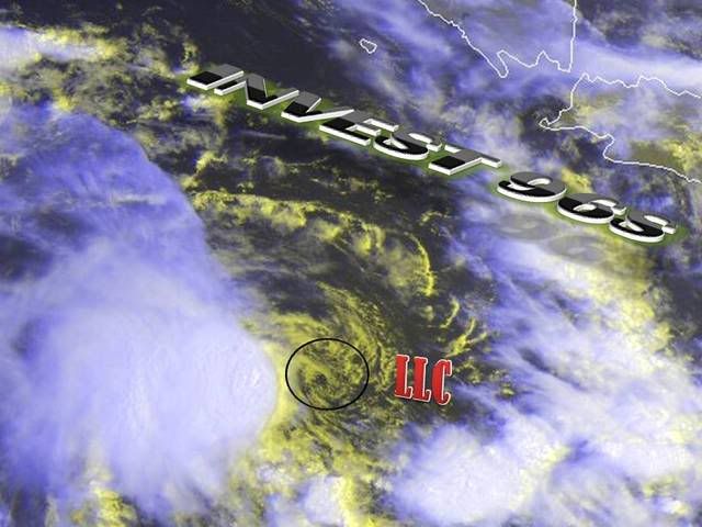
AN AREA OF CONVECTION HAS PERSISTED NEAR 9.6S 100.1E,
APPROXIMATELY 240 NM NORTHEAST OF COCOS ISLAND. RECENT ANIMATED
MULTISPECTRAL SATELLITE IMAGERY SHOWS A BROAD AREA OF CYCLONIC
TURNING WITH AN ELONGATED LOW LEVEL CIRCULATION CENTER (LLCC).
THE LLCC IS CONFIRMED BY A 282324Z QUIKSCAT IMAGE WHICH DEPICTS A
WEAK LLCC WITH STRONGER WINDS ALONG THE PERIPHERY OF THE
CIRCULATION CENTER. CONVECTION ASSOCIATED WITH THE CIRCULATION
HAS BEEN FLARING FOR THE PAST 6 TO 12 HOURS. UPPER LEVEL ANALYSIS
SHOWS THAT VERTICAL WIND SHEAR HAS DECREASED TO LOW TO
MODERATE AND FORMATIVE BANDING NOW APPEARS TO BE FORMING.
CONVECTION IS STRONGEST TO THE WEST OF THE LLCC, BUT IT HAS
STARTED TO INCREASE ALONG THE NORTHEAST PERIPHERY OF THE
DISTURBANCE. MAXIMUM SUSTAINED SURFACE WINDS ARE ESTIMATED AT
18 TO 23 KNOTS. MINIMUM SEA LEVEL PRESSURE IS ESTIMATED TO BE NEAR
1005 MB. BECAUSE CONVECTION HAS YET TO CONSOLIDATE AND THE LLCC
REMAINS ELONGATED, THE POTENTIAL FOR THE DEVELOPMENT OF A
SIGNIFICANT TROPICAL CYCLONE WITHIN THE NEXT 24 HOURS IS POOR.
MSGID/GENADMIN/NAVMARFCSTCEN PEARL HARBOR HI/JTWC//
SUBJ/SIGNIFICANT TROPICAL WEATHER ADVISORY FOR THE INDIAN OCEAN
/REISSUED/280300Z-281800ZFEB2009//
REF/A/MSG/NAVMARFCSTCEN PEARL HARBOR HI/280221ZFEB2009//
AMPN/REF A IS A TROPICAL CYCLONE FORMATION ALERT.//
RMKS/
2. SOUTH INDIAN OCEAN AREA (135E WEST TO COAST OF AFRICA):
A. TROPICAL CYCLONE SUMMARY: NONE.
B. TROPICAL DISTURBANCE SUMMARY:
AN AREA OF CONVECTION HAS PERSISTED NEAR 9.6S 100.1E,
APPROXIMATELY 240 NM NORTHEAST OF COCOS ISLAND. RECENT ANIMATED
MULTISPECTRAL SATELLITE IMAGERY SHOWS A BROAD AREA OF CYCLONIC
TURNING WITH AN ELONGATED LOW LEVEL CIRCULATION CENTER (LLCC).
THE LLCC IS CONFIRMED BY A 282324Z QUIKSCAT IMAGE WHICH DEPICTS A
WEAK LLCC WITH STRONGER WINDS ALONG THE PERIPHERY OF THE
CIRCULATION CENTER. CONVECTION ASSOCIATED WITH THE CIRCULATION
HAS BEEN FLARING FOR THE PAST 6 TO 12 HOURS. UPPER LEVEL ANALYSIS
SHOWS THAT VERTICAL WIND SHEAR HAS DECREASED TO LOW TO
MODERATE AND FORMATIVE BANDING NOW APPEARS TO BE FORMING.
CONVECTION IS STRONGEST TO THE WEST OF THE LLCC, BUT IT HAS
STARTED TO INCREASE ALONG THE NORTHEAST PERIPHERY OF THE
DISTURBANCE. MAXIMUM SUSTAINED SURFACE WINDS ARE ESTIMATED AT
18 TO 23 KNOTS. MINIMUM SEA LEVEL PRESSURE IS ESTIMATED TO BE NEAR
1005 MB. BECAUSE CONVECTION HAS YET TO CONSOLIDATE AND THE LLCC
REMAINS ELONGATED, THE POTENTIAL FOR THE DEVELOPMENT OF A
SIGNIFICANT TROPICAL CYCLONE WITHIN THE NEXT 24 HOURS IS POOR.
0 likes
-
Grifforzer
- Category 1
- Posts: 418
- Joined: Thu Feb 26, 2009 11:27 pm
Australian Government Bureau of Meteorology
Western Australia Tropical Cyclone Warning Center Perth
TROPICAL CYCLONE OUTLOOK
Forecast for area south of 10S between 90E-110E
12:00 PM WDT February 28 2009
=====================================
TROPICAL LOW near 10.0S 102.0E at 9am WDT Saturday about 400 kilometres [220 nautical miles] west of Christmas Island
Central Pressure :1004 hectopascals
Recent movement :near stationary
Tropical Cyclone Formation Potential
====================================
Sunday: Low
Monday: Moderate
Tuesday: Moderate
REMARKS - The low is expected to gradually develop further in the following days and drift slowly to the south and then southeastwards. At this stage, gales are not expected at either Christmas or Cocos Islands within the next 48 hours.
----
Potential lowered to moderate now.
0 likes

-
Tampa_God

- Category 1
- Posts: 333
- Age: 34
- Joined: Wed May 31, 2006 7:27 pm
- Location: New Port Richey/Trinity, FL
Re: WA: Tropical Low (Invest 96S) - (Christmas Island)
Looks like there is too much shear for that to develope. Is the shear suppose to die in the beginning of the weak?
0 likes

-
HURAKAN

- Professional-Met

- Posts: 46086
- Age: 37
- Joined: Thu May 20, 2004 4:34 pm
- Location: Key West, FL
- Contact:
THE AREA OF CONVECTION PREVIOUSLY LOCATED NEAR 11.3S
100.5E, IS NOW LOCATED NEAR 11.2S 100.5E, APPROXIMATELY 215 NM EAST-
NORTHEAST OF THE COCOS ISLANDS. ANIMATED SATELLITE IMAGERY CONTINUES
TO INDICATE A LOW LEVEL CIRCULATION WITHIN THE BROADER MONSOON
TROUGH. HOWEVER, A 28/1239Z SSMIS IMAGE SHOWS LINEAR CONVECTION AND
AN ABSENCE OF CONVECTIVE BANDING. SURROUNDING QUIKSCAT IMAGERY
CONTINUES TO SHOW 20-25 KNOT WINDS ASSOCIATED WITH THE MONSOON
TROUGH. THE DISTURBANCE IS IN A REGION OF GOOD DIFFLUENCE ALOFT, BUT
MODERATE VERTICAL WIND SHEAR. MAXIMUM SUSTAINED SURFACE WINDS ARE
ESTIMATED AT 20 TO 25 KNOTS. MINIMUM SEA LEVEL PRESSURE IS ESTIMATED
TO BE NEAR 1004 MB. THE POTENTIAL FOR THE DEVELOPMENT OF A
SIGNIFICANT TROPICAL CYCLONE WITHIN THE NEXT 24 HOURS REMAINS POOR.
0 likes
-
Grifforzer
- Category 1
- Posts: 418
- Joined: Thu Feb 26, 2009 11:27 pm
BADAN METEOROLOGI DAN GEOFISIKA
Tropical Cyclone Warning Centre (TCWC) Jakarta
Bulletin Information Cyclone Tropical
INVEST 96S
Kondisi tanggal 28/02/2009 pukul 19:00 WIB :
Posisi (Position): 10.2S, 100.1E (sekitar 750 km sebelah selatan barat daya Bengkulu)
--
sorry can't really translate indonesian.
Tropical Cyclone Warning Centre (TCWC) Jakarta
Bulletin Information Cyclone Tropical
INVEST 96S
Kondisi tanggal 28/02/2009 pukul 19:00 WIB :
Posisi (Position): 10.2S, 100.1E (sekitar 750 km sebelah selatan barat daya Bengkulu)
--
sorry can't really translate indonesian.
0 likes
-
Tampa_God
- Category 1
- Posts: 333
- Age: 34
- Joined: Wed May 31, 2006 7:27 pm
- Location: New Port Richey/Trinity, FL
Re:
Grifforzer wrote:BADAN METEOROLOGI DAN GEOFISIKA
Tropical Cyclone Warning Centre (TCWC) Jakarta
Bulletin Information Cyclone Tropical
INVEST 96S
Kondisi tanggal 28/02/2009 pukul 19:00 WIB :
Posisi (Position): 10.2S, 100.1E (sekitar 750 km sebelah selatan barat daya Bengkulu)
--
sorry can't really translate indonesian.
I would guess it says 750 km south southwest from Bengkulu
Out of anything I see out there, this looks the best looking. But still too much shear for this to have the ability to develope into anything at the moment
0 likes
-
Grifforzer
- Category 1
- Posts: 418
- Joined: Thu Feb 26, 2009 11:27 pm
ABIO10 PGTW 010300
MSGID/GENADMIN/NAVMARFCSTCEN PEARL HARBOR HI/JTWC//
SUBJ/SIGNIFICANT TROPICAL WEATHER ADVISORY FOR THE INDIAN OCEAN
/REISSUED/010300Z-011800ZMAR2009//
RMKS/
SOUTH INDIAN OCEAN AREA (135E WEST TO COAST OF AFRICA):
A. TROPICAL CYCLONE SUMMARY: NONE.
B. TROPICAL DISTURBANCE SUMMARY:
(1) THE AREA OF CONVECTION PREVIOUSLY LOCATED NEAR 11.2S
100.5E, IS NOW LOCATED NEAR 11.0S 101.1E, APPROXIMATELY 255 NM EAST-
NORTHEAST OF THE COCOS ISLANDS. ANIMATED MULTISPECTRAL SATELLITE
IMAGERY AND A 28/2255Z SSMI/S SHOW A CONSOLIDATED LOW LEVEL
CIRCULATION CENTER WITH CONVECTION SHEARED TO THE WEST. A 28/1502Z
ASCAT PASS INDICATES WINDS OF 20 KNOTS NEAR THE CENTER, WITH WINDS
OF 30 KNOTS ON THE OUTER PERIPHERIES. THE DISTURBANCE REMAINS UNDER
MODERATE VERTICAL WIND SHEAR, WHICH IS CURRENTLY THE LIMITING FACTOR
FOR DEVELOPMENT. MAXIMUM SUSTAINED SURFACE WINDS ARE ESTIMATED AT 25
TO 30 KNOTS. MINIMUM SEA LEVEL PRESSURE IS ESTIMATED TO BE NEAR 1000
MB. DUE TO THE CONSOLIDATION OF THE LOW LEVEL CENTER, THE POTENTIAL
FOR THE DEVELOPMENT OF A SIGNIFICANT TROPICAL CYCLONE WITHIN THE
NEXT 24 HOURS IS UPGRADED TO FAIR.
0 likes


-
Grifforzer
- Category 1
- Posts: 418
- Joined: Thu Feb 26, 2009 11:27 pm
Tropical Cyclone Warning Center Perth
TROPICAL CYCLONE TECHNICAL BULLETIN
0:50 AM UTC March 1 2009
==============================
At 0:00 AM UTC, Tropical Low [1000 hPa] located at 11.0S 101.2E has 10 minute sustained winds of 30 knots with gusts of 45 knots. The low is reported as moving south at 3 knots.
GALE WARNING
==============
Maximum winds to 30 knots reaching 35 to 40 knots at times in western quadrants from 0600 UTC 01 March 2009. Winds increasing to 30 to 40 knots in all quadrants by 0000 UTC 02 March 2009, with rough to very rough seas and moderate
swell.
12 HRS: 12.1S 102.7E - 30 knots (TROPICAL LOW)
24 HRS: 13.0S 104.4E - 40 knots (CAT 1)
48 HRS: 14.3S 106.2E - 55 knots (CAT 2)
72 HRS: 15.8S 104.2E - 50 knots (CAT 2)
Remarks
=====================
DT2.0 based on shear pattern analysis with separation between 0.75 and 1.25 degrees and reasonably well defined LLCC. MET matches and FT is assigned to 2.0. ASCAT pass at 1520Z indicates near gales under convection in western quadrants. Shear currently over 20 knots and likely to limit development during today but shear expected to drop a little from tonight as the mid latitude trough to the
south pushes the ridge northwards and provides good upper divergence to the south of the system center.
System has been moving south but expected to track SE over the next day or so. Model guidance is consistently forecasting the system to then recurve towards the southwest with a strong mid level anticyclone retrogressing from the east.
0 likes


-
Grifforzer
- Category 1
- Posts: 418
- Joined: Thu Feb 26, 2009 11:27 pm
Tropical Cyclone Warning Center Perth
Tropical Cyclone Technical Bulletin
06:50 AM UTC March 1 2009
===============================================
At 6:00 AM UTC, Tropical Low [1000 hPa] located at 11.3S 102.0E has 10 minute sustained winds of 30 knots with gusts of 45 knots. The low is reported as moving east-southeast at 8 knots.
GALE WARNING
=============
Maximum winds to 30 knots reaching 35 to 40 knots at times in northern and western quadrants. Winds increasing above 34 knots in all quadrants by 0000 UTC 02 March 2009, with rough to very rough seas and moderate swell.
Forecast and Intensity
=======================
12 HRS: 12.1S 103.6E - 30 knots (TROPICAL LOW)
24 HRS: 13.0S 105.2E - 40 knots (CAT 1)
48 HRS: 14.3S 106.1E - 50 knots (CAT 2)
72 HRS: 15.9S 103.6E - 40 knots (CAT 1)
Remarks
=====================
DT2.0 based on shear pattern analysis with separation holding steadily between 0.75 and 1.25 degrees with a reasonably well defined LLCC. MET matches and FT is assigned to 2.0. Scatterometry is indicating near gales to the northwest. Shear currently well over 20 knots and likely to limit development during today but shear expected to drop a little on Monday as the mid latitude trough to the south pushes the ridge northwards and provides good upper divergence to the south of the system centre.
System expected to track SE over the next day or so. Model guidance is consistently forecasting the system to then recurve towards the southwest with a strong mid level anticyclone retrogressing from the east
0 likes
-
P.K.

- Professional-Met
- Posts: 5149
- Joined: Thu Sep 23, 2004 5:57 pm
- Location: Watford, England
- Contact:
Re: WA: Tropical Low (Invest 96S) - (Christmas Island)
Latest technical bulletin on 16U.
AXAU01 APRF 011812
IDW27600
TROPICAL CYCLONE TECHNICAL BULLETIN: AUSTRALIA - WESTERN REGION
Issued by PERTH TROPICAL CYCLONE WARNING CENTRE
at: 1812 UTC 01/03/2009
Name: Tropical Low
Identifier: 16U
Data At: 1800 UTC
Latitude: 12.6S
Longitude: 104.8E
Location Accuracy: within 25 nm [46 km]
Movement Towards: east southeast [115 deg]
Speed of Movement: 15 knots [28 km/h]
Maximum 10-Minute Wind: 30 knots [55 km/h]
Maximum 3-Second Wind Gust: 45 knots [85 km/h]
Central Pressure: 1000 hPa
Radius of 34-knot winds NE quadrant:
Radius of 34-knot winds SE quadrant:
Radius of 34-knot winds SW quadrant:
Radius of 34-knot winds NW quadrant:
Radius of 48-knot winds NE quadrant:
Radius of 48-knot winds SE quadrant:
Radius of 48-knot winds SW quadrant:
Radius of 48-knot winds NW quadrant:
Radius of 64-knot winds:
Radius of Maximum Winds: N/A
Dvorak Intensity Code: T2.0/2.0/D1.0/24HRS
Pressure of outermost isobar: 1004 hPa
Radius of outermost closed isobar: 70 nm [130 km]
Storm Depth: Medium
FORECAST DATA
Date/Time : Location : Loc. Accuracy: Max Wind : Central Pressure
[UTC] : degrees : nm [km]: knots[km/h]: hPa
+12: 02/0600: 13.3S 106.9E: 055 [100]: 030 [055]: 999
+24: 02/1800: 13.8S 107.8E: 085 [155]: 045 [085]: 989
+36: 03/0600: 14.3S 107.3E: 120 [220]: 050 [095]: 987
+48: 03/1800: 14.9S 106.1E: 150 [280]: 045 [085]: 991
+60: 04/0600: 15.7S 104.4E: 190 [350]: 045 [085]: 992
+72: 04/1800: 17.0S 102.1E: 230 [425]: 035 [065]: 998
REMARKS:
Dvorak analysis: Shear pattern remains at DT2.0, average of 1.5-2.0 in recent 3
hours. MET=1.5 but FT assigned to 2.0.
Development continues to be restricted by ongoing NE shear of at least 20 knots.
Intensification may occur in 18-24 hours as shear drops a little with mid
latitude trough to the south providing good upper divergence to the south of the
system centre.
System expected to track SE over the next 24 hours prior to commencing a
recurvature towards the southwest with a strong mid level anticyclone
retrogressing from the east.
Copyright Commonwealth of Australia
==
The next bulletin for this system will be issued by: 02/0100 UTC by Perth TCWC.
0 likes


-
HURAKAN
- Professional-Met
- Posts: 46086
- Age: 37
- Joined: Thu May 20, 2004 4:34 pm
- Location: Key West, FL
- Contact:
Re: WA: Tropical Low (Invest 96S) - (Christmas Island)

WTXS21 PGTW 011400
SUBJ/TROPICAL CYCLONE FORMATION ALERT//
RMKS/
1. FORMATION OF A SIGNIFICANT TROPICAL CYCLONE IS POSSIBLE WITHIN
180 NM EITHER SIDE OF A LINE FROM 11.6S 102.6E TO 15.0S 107.2E
WITHIN THE NEXT 12 TO 24 HOURS. AVAILABLE DATA DOES NOT JUSTIFY
ISSUANCE OF NUMBERED TROPICAL CYCLONE WARNINGS AT THIS TIME.
WINDS IN THE AREA ARE ESTIMATED TO BE 25 TO 30 KNOTS. METSAT IM-
AGERY AT 011300Z INDICATES THAT A CIRCULATION CENTER IS LOCATED
NEAR 12.1S 103.3E. THE SYSTEM IS MOVING SOUTHEASTWARD AT 14
KNOTS.
2. REMARKS: THE AREA OF CONVECTION PREVIOUSLY LOCATED NEAR 11.0S
101.1E, IS NOW LOCATED NEAR 12.1S 103.3E, APPROXIMATELY 375 NM EAST
OF COCOS ISLAND. ANIMATED MULTISPECTRAL SATELLITE IMAGERY DEPICTS A
WELL-DEFINED, EXPOSED LOW-LEVEL CIRCULATION CENTER (LLCC) WITH DEEP
CONVECTION RE-DEVELOPING JUST WEST OF THE CENTER. A 01/1226Z SSMIS
IMAGE INDICATED AN IMPROVING LLCC WITH ISOLATED CONVECTION NEAR
THE CENTER. EARLIER SCATTEROMETER SUPPORTS 25-30 KNOT WINDS WRAPPING
INTO THE CENTER. HIGH VERTICAL WIND SHEAR (VWS) REMAINS THE PRIMARY
LIMITING FACTOR WITH 30-40 KNOTS OVER THE SYSTEM. HOWEVER, VWS IS
EXPECTED TO DECREASE SIGNIFICANTLY WITHIN THE NEXT 12 HOURS AS THE
SYSTEM BEGINS TO TURN SOUTHEASTWARD, TRACKING UNDER THE UPPER-
LEVEL RIDGE AXIS AND REDUCED VWS. ADDITIONALLY, AN APPROACHING
SHORTWAVE TROUGH CURRENTLY SOUTHWEST OF THE SYSTEM IS FORECAST TO
SHIFT EAST PROVIDING AN IMPROVED POLEWARD OUTFLOW CHANNEL WITHIN
THE NEXT 24 HOURS. SST AND OCEAN HEAT CONTENT ARE FAVORABLE FOR
FURTHER DEVELOPMENT. MAXIMUM SUSTAINED SURFACE WINDS ARE ESTIMATED
AT 25 TO 30 KNOTS. MINIMUM SEA LEVEL PRESSURE IS ESTIMATED TO BE
NEAR 1002 MB. BASED ON THE FORECAST TRACK SOUTHEASTWARD TO SOUTH-
WARD, THE POTENTIAL FOR THE DEVELOPMENT OF A SIGNIFICANT TROPICAL
CYCLONE WITHIN THE NEXT 24 HOURS IS GOOD.
3. THIS ALERT WILL BE REISSUED, UPGRADED TO WARNING OR CANCELLED
BY 021400Z.//
0 likes
-
Grifforzer
- Category 1
- Posts: 418
- Joined: Thu Feb 26, 2009 11:27 pm
Tropical Cyclone Warning Center Perth
Tropical Cyclone Technical Bulletin
0:50 AM UTC March 2 2009
==============================
At 0:00 AM UTC, Tropical Low [1000 hPa] located at 13.5S 105.6E has 10 minute sustained winds of 30 knots with gusts of 45 knots. The low is reported as moving southeast at 13 knots.
Storm Warning
==============
Maximum winds to 30 knots reaching 35 to 40 knots at times in northern and western quadrants. Winds increasing above 34 knots in all quadrants by 1200 UTC 02 March 2009 with rough to very rough seas and moderate swell. Maximum winds
increasing to 50 knots by 0000 UTC 03 March.
Winds above 48 knots within 30 nautical miles of centre by 0000 UTC 03 March with very rough to high seas and moderate to heavy swell.
Forecast and Intensity
=======================
12 HRS: 14.5S 107.2E - 40 knots (CAT 1)
24 HRS: 15.5S 107.2E - 50 knots (CAT 2)
48 HRS: 16.7S 104.6E - 45 knots (CAT 1)
72 HRS: 18.6S 100.2E - 30 knots (TROPICAL LOW)
Additional Information
=====================
Dvorak analysis: Shear Pattern. Low level centre very close to strongest temperature gradient. DT assigned to 2.5. MET=2.5 and FT = 2.5.
The system has developed overnight with deep convection occurring to the west and southwest of the LLCC. Development continues to be restricted by ongoing NE shear of at least 20 knots. Intensification may occur in 12-24 hours as the shear drops with a mid latitude trough to the south providing good upper divergence to the south of the system centre.
System expected to track SE over the next 12-18 hours prior to commencing a recurvature towards the southwest as a strong mid level anticyclone retrogresses from the east.
0 likes
Who is online
Users browsing this forum: No registered users and 76 guests