SIO: Tropical Depression 10R (19S)

Moderator: S2k Moderators

Message
Author
User avatar
wyq614
Category 3
Category 3
Posts: 827
Age: 35
Joined: Sun Dec 02, 2007 12:32 am
Location: Beijing, China (Hometown: Qingdao, China, 36.06N 120.43E)
Contact:

SIO: Tropical Depression 10R (19S)

#1 Postby wyq614 » Sat Feb 28, 2009 8:46 am

Image

Initial position is 11.2S 75E
0 likes   

Grifforzer
Category 1
Category 1
Posts: 418
Joined: Thu Feb 26, 2009 11:27 pm

#2 Postby Grifforzer » Sat Feb 28, 2009 8:43 pm

Mauritius Meteorological Services

LOW [1004 hPa] NEAR 10.0S 75.0E

Reported as quasi-stationary.

Low is expected to develop further in the coming days
0 likes   

User avatar
HURAKAN
Professional-Met
Professional-Met
Posts: 46086
Age: 37
Joined: Thu May 20, 2004 4:34 pm
Location: Key West, FL
Contact:

#3 Postby HURAKAN » Sat Feb 28, 2009 10:26 pm

Image

Image
0 likes   

User avatar
Crostorm
Category 5
Category 5
Posts: 2060
Age: 49
Joined: Mon Dec 25, 2006 3:51 pm
Location: Croatia-Europe
Contact:

Re: SIO: Invest 97S

#4 Postby Crostorm » Sun Mar 01, 2009 6:05 pm

Image
0 likes   

Grifforzer
Category 1
Category 1
Posts: 418
Joined: Thu Feb 26, 2009 11:27 pm

#5 Postby Grifforzer » Sun Mar 01, 2009 7:38 pm

abio10 pgtw 011800
msgid/genadmin/navmarfcstcen Pearl Harbor hi/jtwc//
subj/significant tropical weather advisory for the Indian

2. South Indian Ocean area (135e west to coast of Africa):
a. Tropical cyclone summary: none.
B. Tropical disturbance summary:

(1) TCFA for 96S..

:rarrow: 
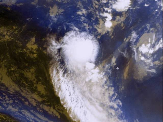
(2) an area of convection has persisted near 9.6s 75.6e,
approximately 225 nm southeast of Diego Garcia. Recent animated
multispectral imagery shows a well-defined low level circulation
center embedded within the monsoon trough. A 01/1322z Quikscat pass
shows winds of 20 kts near the center. The convection associated
with the system is weak and disorganized, most likely due to
moderate easterly vertical wind shear. Maximum sustained surface
winds are estimated at 15 to 20 knots. Minimum sea level pressure
is estimated to be near 1006 mb. The potential for the development
of a significant tropical cyclone within the next 24 hours is poor
.
0 likes   

User avatar
HURAKAN
Professional-Met
Professional-Met
Posts: 46086
Age: 37
Joined: Thu May 20, 2004 4:34 pm
Location: Key West, FL
Contact:

#6 Postby HURAKAN » Sun Mar 01, 2009 7:40 pm

Image

Image
0 likes   

Grifforzer
Category 1
Category 1
Posts: 418
Joined: Thu Feb 26, 2009 11:27 pm

#7 Postby Grifforzer » Tue Mar 03, 2009 3:08 pm

Joint Typhoon Warning Center
Tropical Disturbance Summary
ABIO10 Southern Indian Ocean
6:00 PM UTC March 3 2009
=========================================

An area of convection (97S) located at 12.4S 77.6E or 430 NM southeast of Diego Garcia. Recent animated multispectral imagery shows a very weak low level circulation center embedded within the monsoon trough. A 1257z Windscat Coriolis Pass and a 1229z Quikscat Pass shows a broad and weak low level circulation center embedded within the monsoon trough with stronger convective banding well displaced along the periphery of the trough. The convection associated with the system has been flaring, shifting along the monsoon trough and is currently consolidating. The sea surface temperatures for the region are favorable for development. Analysis of the upper level environment indicates weak vertical wind shear and good outflow.

Maximum sustained winds near the center is 15-20 knots with a minimum sea level pressure of 1006 MB. Based on the weak and disorganized low level circulation center, the potential for this disturbance to form into a significant tropical cyclone within the next 24 hours remains POOR.


Mauritius Meteorological Services
High Sea Forecast
12:00 PM UTC March 3 2009
===============================

LOW 1004 HPA NEAR 12S 77E

THIS LOW IS EXPECTED TO INTENSIFY FURTHER
0 likes   

Grifforzer
Category 1
Category 1
Posts: 418
Joined: Thu Feb 26, 2009 11:27 pm

#8 Postby Grifforzer » Wed Mar 04, 2009 4:41 pm

Mauritius Meteorological Services
High Seas Forecast
12:00 PM UTC March 4 2009
==========================

SHALLOW LOW NEAR 11S 78E

Joint Typhoon Warning Center
Tropical Disturbance Summary
ABIO10 Southern Indian Ocean
18:00 PM UTC March 4 2009
=========================================

An area of convection (97S) located at 11.0S 76.8E or 330 NM southeast of Diego Garcia. Recent animate multispectral imagery shows a very weak elongated low level circulation center embedded within the monsoon trough. Scatterometry data confirms the low level circulation center and depicts a broad and weak center with stronger winds along the periphery of the circulation. The convection associated with the system has been flaring while shifting along the monsoon trough, and has not shown signs of further consolidation over the past 24 hours. The sea surface temperatures for the region are favorable for development. Analysis of the upper level environment indicates moderate vertical wind shear and the potential for good outflow.

Maximum sustianed winds near the center is 15-20 knots with a minimum sea level pressure of 1006 MB. Based on the weak and disorganized low level circulation center, the potential for this disturbance to form into a significant tropical cyclone within the next 24 hours remains POOR.
0 likes   

User avatar
HURAKAN
Professional-Met
Professional-Met
Posts: 46086
Age: 37
Joined: Thu May 20, 2004 4:34 pm
Location: Key West, FL
Contact:

Re: SIO: Invest 97S

#9 Postby HURAKAN » Wed Mar 04, 2009 5:00 pm

Image
0 likes   

Grifforzer
Category 1
Category 1
Posts: 418
Joined: Thu Feb 26, 2009 11:27 pm

#10 Postby Grifforzer » Thu Mar 05, 2009 3:02 pm

ABIO10 PGTW 051800
MSGID/GENADMIN/NAVMARFCSTCEN PEARL HARBOR HI/JTWC//
SUBJ/SIGNIFICANT TROPICAL WEATHER ADVISORY FOR THE INDIAN
/OCEAN/051800Z-061800ZMAR2009//
RMKS/
1. NORTH INDIAN OCEAN AREA (MALAY PENINSULA WEST TO COAST OF AFRICA):
A. TROPICAL CYCLONE SUMMARY: NONE.
B. TROPICAL DISTURBANCE SUMMARY: NONE.
2. SOUTH INDIAN OCEAN AREA (135E WEST TO COAST OF AFRICA):
A. TROPICAL CYCLONE SUMMARY: NONE.
B. TROPICAL DISTURBANCE SUMMARY: NONE.

---

I did not see any dissipation note for 97S..
0 likes   

Fadil
Tropical Low
Tropical Low
Posts: 18
Joined: Tue Jan 29, 2008 4:51 am

Re: SIO: Invest 97S

#11 Postby Fadil » Fri Mar 06, 2009 11:06 am

Image

Its coming guys!
0 likes   

Grifforzer
Category 1
Category 1
Posts: 418
Joined: Thu Feb 26, 2009 11:27 pm

#12 Postby Grifforzer » Fri Mar 06, 2009 5:42 pm

Mauritius Meteorological Services
High Seas Forecast
12:00 PM UTC March 6 2009
==========================

LOW [1004 HPA] NEAR THE POINT 12S 82E IS EXPECTED TO DEEPEN FURTHER. IT IS LIKELY TO MOVE IN A SOUTHERLY DIRECTION.

--
Still nothing from ABIO10 bulletins.
0 likes   

User avatar
HURAKAN
Professional-Met
Professional-Met
Posts: 46086
Age: 37
Joined: Thu May 20, 2004 4:34 pm
Location: Key West, FL
Contact:

#13 Postby HURAKAN » Fri Mar 06, 2009 5:48 pm

Image

Not much here.
0 likes   

User avatar
Chacor
Category 5
Category 5
Posts: 10229
Joined: Mon Oct 02, 2006 10:43 pm
Location: Singapore

SWIO: Tropical Disturbance 10R (97S needs to be unarchived)

#14 Postby Chacor » Sun Mar 08, 2009 8:41 am

WTIO30 FMEE 081211

RSMC / TROPICAL CYCLONE CENTRE / LA REUNION
TROPICAL CYCLONE FORECAST WARNING (SOUTH-WEST INDIAN OCEAN)

0.A WARNING NUMBER : 2/10/20082009
1.A TROPICAL DISTURBANCE 10

2.A POSITION 2009/03/08 AT 1200 UTC :
WITHIN 20 NM RADIUS OF POINT 14.9S / 82.1E
(FOURTEEN DECIMAL NINE DEGREES SOUTH AND EIGHTY TWO DECIMAL ONE DEGREES
EAST)
MOVEMENT : EAST-SOUTH-EAST 12 KT

3.A DVORAK ANALYSIS : 1.5/1.5 /S 0.0/6 H
4.A CENTRAL PRESSURE : 1000 HPA
5.A MAX AVERAGE WIND SPEED (10 MN) : 20 KT
RADIUS OF MAXIMUM WINDS (RMW) : NIL

6.A EXTENSION OF WINDS BY QUADRANTS (KM):


7.A FIRST CLOSED ISOBARE (PRESSURE / AVERAGE DIAM): 1007 HPA / 1400 KM
8.A VERTICAL EXTENSION OF CYCLONE CIRCULATION: MEDIUM

1.B FORECASTS:
12H: 2009/03/09 00 UTC: 16.1S/83.7E, MAX WIND=025KT, TROP. DISTURBANCE.
24H: 2009/03/09 12 UTC: 17.6S/85.5E, MAX WIND=030KT, TROP. DEPRESSION.
36H: 2009/03/10 00 UTC: 18.6S/86.0E, MAX WIND=030KT, TROP. DEPRESSION.
48H: 2009/03/10 12 UTC: 18.8S/85.3E, MAX WIND=035KT, MODERATE TROP. STORM
..
60H: 2009/03/11 00 UTC: 18.6S/84.5E, MAX WIND=035KT, MODERATE TROP. STORM
..
72H: 2009/03/11 12 UTC: 18.5S/83.7E, MAX WIND=030KT, TROP. DEPRESSION.

2.B OTHER INFORMATIONS:
THE SYSTEM BARELY INTENSIFIES. IT STILL UNDERGOES AN UPPER LEVEL
CONSTRAINT AS SHOWN BY THE PARTIALLY EXPOSED LLCC IN THE NORTH OF THE
CONVECTION. THE POLEWARD DIVERGENCE IS WELL ESTABLISHED.
LOW LEVEL INFLOW IS RATHER GOOD EQUATORWARDS, BUT IS WEAKENED POLEWARDS
BY A TRANSIENT LOW LEVEL TROUGH. THE LLCC REMAINS RATHER POORLY DEFINED
ON THE ANIMATED IMAGERY.
AT 0900Z, BUOY NR 16580 MEASURED 998.7 HPA IN THE VICINITY OF THE
ESTIMATED CENTRE (1000 HPA WITH BAROMETRIC TIDE).

THE SYSTEM SHOULD INTENSIFY VERY GRADUALLY WITHIN AN ENVIRONMENT WHICH
SHOULD IMPROVE MAINLY WITH THE DECREASE OF THE WINDSHEAR.
THE SYSTEM TRACKS SOUTHEASTWARDS UNDER THE STEERING INFLUENCE OF A
MID-LEVEL NEAR-EQUATORIAL RIDGE. BEYOND 36H, AVAILABLE MODELS SHOW A
CURVE AND THEN A WESTWARDS TRACK, UNDER THE INFLUENCE OF THE BUILDING
SUBTROPICAL RIDGE.
FORECAST IS BASED ON A CONSENSUS OF THE AVAILABLE NWP.

AT THIS STAGE, THIS SYSTEM DOES NOT JUSTIFY ISSUANCE OF REGULAR WARINIGS.
0 likes   

User avatar
HURAKAN
Professional-Met
Professional-Met
Posts: 46086
Age: 37
Joined: Thu May 20, 2004 4:34 pm
Location: Key West, FL
Contact:

#15 Postby HURAKAN » Sun Mar 08, 2009 10:59 am

Image
0 likes   

User avatar
HURAKAN
Professional-Met
Professional-Met
Posts: 46086
Age: 37
Joined: Thu May 20, 2004 4:34 pm
Location: Key West, FL
Contact:

#16 Postby HURAKAN » Sun Mar 08, 2009 11:33 am

Image
0 likes   

User avatar
HURAKAN
Professional-Met
Professional-Met
Posts: 46086
Age: 37
Joined: Thu May 20, 2004 4:34 pm
Location: Key West, FL
Contact:

#17 Postby HURAKAN » Sun Mar 08, 2009 12:18 pm

08/1430 UTC 15.1S 82.8E T1.5/1.5 97S -- Southwest Indian
0 likes   

User avatar
HURAKAN
Professional-Met
Professional-Met
Posts: 46086
Age: 37
Joined: Thu May 20, 2004 4:34 pm
Location: Key West, FL
Contact:

Re: SIO: Invest 97S (Tropical Disturbance 10R)

#18 Postby HURAKAN » Sun Mar 08, 2009 2:42 pm

THE AREA OF CONVECTION PREVIOUSLY LOCATED NEAR 14.4S
81.2E, IS NOW LOCATED NEAR 14.8S 82.3E, APPROXIMATELY 730 NM
SOUTHEAST OF DIEGO GARCIA. ANIMATED MULTISPECTRAL IMAGERY AND A
081208Z QUIKSCAT IMAGE INDICATES THAT THE LOW LEVEL CIRCULATION
CENTER (LLCC) HAS BECOME FAIRLY CONCENTRIC AND IS INCREASING IN
INTENSITY. CONVECTION HAS BEEN FLARING OVER THE LLCC BUT HAS BEEN
CYCLIC OVER THE PAST 24 HOURS. UPPER LEVEL ANALYSIS INDICATES THE
LLCC IS CURRENTLY LOCATED EQUATORWARD OF THE UPPER LEVEL SUBTROPICAL
RIDGE AXIS, WHICH IS PROVIDING AMPLE POLEWARD OUTFLOW. THE LOCATION
OF THE LLCC IN RELATION TO THE RIDGE AXIS IS HELPING TO KEEP THE
VERTICAL WIND SHEAR LOW. AN UPPER-LEVEL LONGWAVE TROUGH UPSTREAM HAS
BEEN HELPING TO ENHANCE POLEWARD OUTFLOW, BUT HAS KEPT THE VERTICAL
WIND SHEAR HIGH ON THE SOUTHWESTERN QUADRANT OF THE AREA. MAXIMUM
SUSTAINED SURFACE WINDS ARE ESTIMATED AT 20 TO 25 KNOTS. MINIMUM SEA
LEVEL PRESSURE IS ESTIMATED TO BE NEAR 1004 MB. THE POTENTIAL FOR
THE DEVELOPMENT OF A SIGNIFICANT TROPICAL CYCLONE WITHIN THE NEXT 24
HOURS IS UPGRADED TO FAIR.
0 likes   

User avatar
HURAKAN
Professional-Met
Professional-Met
Posts: 46086
Age: 37
Joined: Thu May 20, 2004 4:34 pm
Location: Key West, FL
Contact:

#19 Postby HURAKAN » Sun Mar 08, 2009 2:49 pm

Image
0 likes   

User avatar
HURAKAN
Professional-Met
Professional-Met
Posts: 46086
Age: 37
Joined: Thu May 20, 2004 4:34 pm
Location: Key West, FL
Contact:

#20 Postby HURAKAN » Sun Mar 08, 2009 5:46 pm

Image

08/1900 UTC 14.9S 83.4E T1.5/1.5 97S -- Southwest Indian
0 likes   


Return to “2009”

Who is online

Users browsing this forum: No registered users and 41 guests