Australian Government Bureau of Meteorology
Queensland
Tropical Cyclone Warning Centre
Media: The Standard Emergency Warning Signal should NOT be used with this
warning.
TOP PRIORITY
TROPICAL CYCLONE ADVICE NUMBER 13
Issued by the Bureau of Meteorology, Brisbane
Issued at 11:05am on Saturday the 7th of March 2009
A Cyclone WARNING remains current for coastal and island communities from
Lucinda to Saint Lawrence. A Cyclone WATCH remains current for coastal and
island communities from Saint Lawrence to Hervey Bay.
The Cyclone Warning has been cancelled between Innisfail and Lucinda.
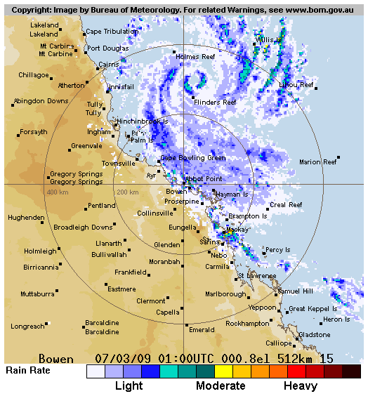
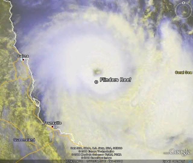
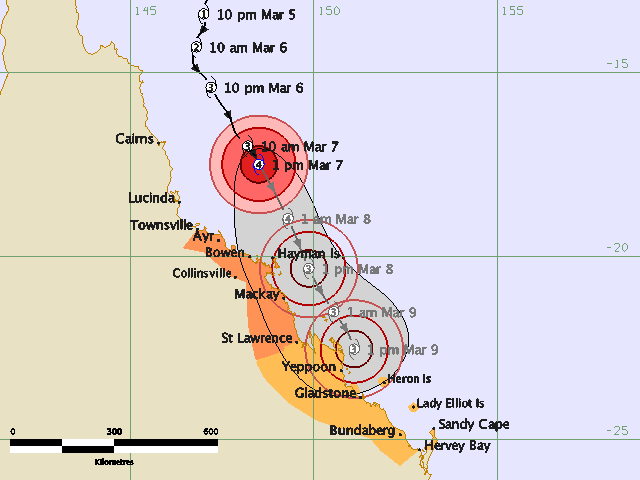
Severe Tropical Cyclone Hamish, a category 3 cyclone, is located in the
northwestern Coral Sea and at 10:00 am EST was estimated to be 250 kilometres
east of Cairns and 295 kilometres north northeast of Townsville, moving south
southeast at 16 kilometres per hour.
Severe Tropical Cyclone Hamish is expected to continue moving south to southeast
parallel to the coast.
Damaging wind gusts may affect coastal and island communities between Lucinda
and St Lawrence during the next 24 hours.
DESTRUCTIVE WINDS may affect coastal and island communities between Ayr and St
Lawrence [including the Whitsunday islands] early on Sunday morning.
Damaging wind gusts may develop about coastal and island communities between St
Lawrence and Hervey Bay [including Heron and Lady Elliot Islands] within 24 to
48 hours.
As the cyclone moves southward and deepens overnight, sea levels are expected to
be elevated above the normal tide along the coastline south of the cyclone.
Large waves may produce minor flooding along the foreshore. People living in
areas likely to be affected by this flooding should take measures to protect
their property as much as possible and be prepared to help their neighbours.
Areas of heavy rainfall may cause flooding in some coastal streams and rivers
between Townsville and Mackay during the next 24 hours.
Details of Severe Tropical Cyclone Hamish at 10:00 am EST:
.Centre located near...... 16.9 degrees South 148.1 degrees East
.Location accuracy........ within 19 kilometres
.Recent movement.......... towards the south southeast at 16 kilometres per hour
.Wind gusts near centre... 220 kilometres per hour
.Severity category........ 3
.Central pressure......... 960 hectoPascals
People between Innisfail and St Lawrence should immediately commence or continue
preparations, especially securing boats and property.
People between St Lawrence and Hervey Bay should consider what action they will
need to take if the cyclone threat increases. If you are unsure about the
actions to be taken, information is available from your local government or
local State Emergency Service.
The next advice will be issued by 2:00 pm EST Saturday 07 March.
This warning is also available through TV and Radio Broadcasts; the Bureau's
website at http://www.bom.gov.au or call 1300 659 212. The Bureau and the State
Emergency Service would appreciate this warning being broadcast regularly.
Coral Sea: HAMISH - Tropical Cyclone
Moderator: S2k Moderators
-
HURAKAN

- Professional-Met

- Posts: 46086
- Age: 37
- Joined: Thu May 20, 2004 4:34 pm
- Location: Key West, FL
- Contact:
TPPS10 PGTW 070015
A. TROPICAL CYCLONE 18P (HAMISH)
B. 06/2330Z
C. 17.1S
D. 148.3
E. ONE/MTSAT
F. T6.0/6.0/D2.0/24HRS STT: D1.0/06HRS
G. IR/EIR/VIS/MSI
H. REMARKS: 07A/PBO IRREG EYE/ANMTN. SMALL 15NM IRREG OW EYE
SURR BY A BLACK CONVECTIVE RING YIELDS A 5.5 E#, WITH .5 ADDED
FOR EYE ADJUSTMENT. PT AGREES. MET YIELDS A 5.5. DBO DT AND
PT.
I. ADDITIONAL POSITIONS:
06/1829Z 16.5S 147.8E AMSU
06/1959Z 16.4S 147.9E AMSU
06/2040Z 16.8S 148.2E SSMI
SMITH
0 likes

-
HURAKAN
- Professional-Met
- Posts: 46086
- Age: 37
- Joined: Thu May 20, 2004 4:34 pm
- Location: Key West, FL
- Contact:


WTPS31 PGTW 070300
MSGID/GENADMIN/NAVMARFCSTCEN PEARL HARBOR HI/JTWC//
SUBJ/TROPICAL CYCLONE 18P (HAMISH) WARNING NR 004//
RMKS/
1. TROPICAL CYCLONE 18P (HAMISH) WARNING NR 04
01 ACTIVE TROPICAL CYCLONE IN SOUTHPAC
MAX SUSTAINED WINDS BASED ON ONE-MINUTE AVERAGE
---
WARNING POSITION:
070000Z --- NEAR 17.1S 148.2E
MOVEMENT PAST SIX HOURS - 150 DEGREES AT 09 KTS
POSITION ACCURATE TO WITHIN 020 NM
POSITION BASED ON CENTER LOCATED BY SATELLITE
PRESENT WIND DISTRIBUTION:
MAX SUSTAINED WINDS - 090 KT, GUSTS 110 KT
WIND RADII VALID OVER OPEN WATER ONLY
RADIUS OF 064 KT WINDS - 020 NM NORTHEAST QUADRANT
020 NM SOUTHEAST QUADRANT
020 NM SOUTHWEST QUADRANT
020 NM NORTHWEST QUADRANT
RADIUS OF 050 KT WINDS - 035 NM NORTHEAST QUADRANT
035 NM SOUTHEAST QUADRANT
030 NM SOUTHWEST QUADRANT
030 NM NORTHWEST QUADRANT
RADIUS OF 034 KT WINDS - 070 NM NORTHEAST QUADRANT
070 NM SOUTHEAST QUADRANT
060 NM SOUTHWEST QUADRANT
060 NM NORTHWEST QUADRANT
REPEAT POSIT: 17.1S 148.2E
---
FORECASTS:
12 HRS, VALID AT:
071200Z --- 18.8S 149.1E
MAX SUSTAINED WINDS - 095 KT, GUSTS 115 KT
WIND RADII VALID OVER OPEN WATER ONLY
RADIUS OF 064 KT WINDS - 020 NM NORTHEAST QUADRANT
020 NM SOUTHEAST QUADRANT
020 NM SOUTHWEST QUADRANT
020 NM NORTHWEST QUADRANT
RADIUS OF 050 KT WINDS - 035 NM NORTHEAST QUADRANT
035 NM SOUTHEAST QUADRANT
030 NM SOUTHWEST QUADRANT
030 NM NORTHWEST QUADRANT
RADIUS OF 034 KT WINDS - 085 NM NORTHEAST QUADRANT
085 NM SOUTHEAST QUADRANT
075 NM SOUTHWEST QUADRANT
075 NM NORTHWEST QUADRANT
VECTOR TO 24 HR POSIT: 150 DEG/ 08 KTS
---
24 HRS, VALID AT:
080000Z --- 20.1S 149.9E
MAX SUSTAINED WINDS - 100 KT, GUSTS 125 KT
WIND RADII VALID OVER OPEN WATER ONLY
RADIUS OF 064 KT WINDS - 020 NM NORTHEAST QUADRANT
020 NM SOUTHEAST QUADRANT
020 NM SOUTHWEST QUADRANT
020 NM NORTHWEST QUADRANT
RADIUS OF 050 KT WINDS - 040 NM NORTHEAST QUADRANT
040 NM SOUTHEAST QUADRANT
035 NM SOUTHWEST QUADRANT
035 NM NORTHWEST QUADRANT
RADIUS OF 034 KT WINDS - 085 NM NORTHEAST QUADRANT
085 NM SOUTHEAST QUADRANT
075 NM SOUTHWEST QUADRANT
075 NM NORTHWEST QUADRANT
VECTOR TO 36 HR POSIT: 160 DEG/ 09 KTS
---
36 HRS, VALID AT:
081200Z --- 21.7S 150.6E
MAX SUSTAINED WINDS - 095 KT, GUSTS 115 KT
WIND RADII VALID OVER OPEN WATER ONLY
RADIUS OF 064 KT WINDS - 025 NM NORTHEAST QUADRANT
025 NM SOUTHEAST QUADRANT
025 NM SOUTHWEST QUADRANT
025 NM NORTHWEST QUADRANT
RADIUS OF 050 KT WINDS - 045 NM NORTHEAST QUADRANT
045 NM SOUTHEAST QUADRANT
040 NM SOUTHWEST QUADRANT
040 NM NORTHWEST QUADRANT
RADIUS OF 034 KT WINDS - 095 NM NORTHEAST QUADRANT
095 NM SOUTHEAST QUADRANT
085 NM SOUTHWEST QUADRANT
085 NM NORTHWEST QUADRANT
VECTOR TO 48 HR POSIT: 155 DEG/ 08 KTS
---
EXTENDED OUTLOOK:
48 HRS, VALID AT:
090000Z --- 23.1S 151.3E
MAX SUSTAINED WINDS - 090 KT, GUSTS 110 KT
WIND RADII VALID OVER OPEN WATER ONLY
RADIUS OF 064 KT WINDS - 030 NM NORTHEAST QUADRANT
030 NM SOUTHEAST QUADRANT
030 NM SOUTHWEST QUADRANT
030 NM NORTHWEST QUADRANT
RADIUS OF 050 KT WINDS - 050 NM NORTHEAST QUADRANT
050 NM SOUTHEAST QUADRANT
045 NM SOUTHWEST QUADRANT
045 NM NORTHWEST QUADRANT
RADIUS OF 034 KT WINDS - 100 NM NORTHEAST QUADRANT
100 NM SOUTHEAST QUADRANT
090 NM SOUTHWEST QUADRANT
090 NM NORTHWEST QUADRANT
---
REMARKS:
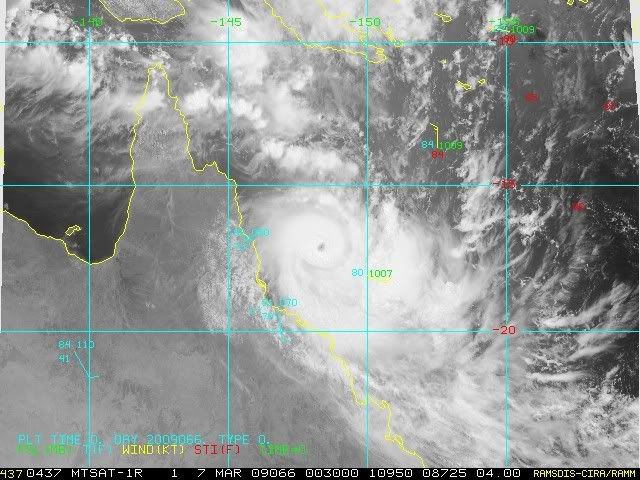
070300Z POSITION NEAR 17.5S 148.4E.
TROPICAL CYCLONE (TC) 18P (HAMISH), LOCATED APPROXIMATELY 140 NM EAST
OF CAIRNS, AUSTRALIA HAS TRACKED SOUTH-SOUTHEASTWARD AT 10 KNOTS OVER
THE PAST 06 HOURS. ANIMATED INFRARED SATELLITE IMAGERY INDICATES THAT
THE SYSTEM HAS MAINTAINED ITS ORGANIZATION WITH BRIEF PERIODS HAVING
A CLOUD FILLED EYE. BASED ON RADAR, THE EYE DIAMETER HAS DECREASED IN
SIZE TO 15 NM. THERE IS HIGH CONFIDENCE IN THE CURRENT POSITION AND
MOTION BASED ON THE WELL-DEFINED EYE EVIDENT ON THE BOWEN RADAR
IMAGERY. TC 18P PASSED OVER HOLMES REEF NEAR 05/20Z WITH MAXIMUM
SUSTAINED SURFACE WINDS REPORTED AT 77 KNOTS AND MINIMUM SLP OF 960.9
MB. TC 18P HAS MODERATE INTENSIFICATION OVER THE PAST 12 HOURS. THE
CURRENT INTENSITY IS BASED ON OBSERVATIONS REPORTED AT HOLMES REEF
AND FLINDERS REEF. DVORAK ESTIMATES OF 115 KNOTS FROM PGTW APPEAR TO
BE SLIGHTLY HIGHER THAN OBSERVATIONS ARE INDICATING. ANIMATED WATER
VAPOR IMAGERY CONTINUES TO INDICATE RADIAL OUTFLOW WITH STRONG
POLEWARD OUTFLOW ENHANCED BY MIDLATITUDE WESTERLIES SOUTH OF THE
SYSTEM. THE SYSTEM IS LOCATED WITHIN A FAVORABLE ENVIRONMENT WITH
WEAK VERTICAL WIND SHEAR, WARM SST > 28C AND DEEP MOISTURE. TC 18P
IS FORECAST TO TRACK SOUTH-SOUTHEASTWARD UNDER THE STEERING
INFLUENCE OF THE MID-LEVEL SUBTROPICAL RIDGE POSITIONED EAST OF THE
SYSTEM. THE AVAILABLE DYNAMIC AIDS ARE IN GOOD AGREEMENT WITH THIS
TRACK. TC 18P SHOULD CONTINUE TO INTENSIFY THROUGH TAU 24 BUT IS
EXPECTED TO WEAKEN SLIGHTLY AT TAU 36 DUE TO INCREASING VERTICAL
WIND SHEAR AND INTERACTION WITH LAND. MAXIMUM SIGNIFICANT WAVE
HEIGHT AT 070000Z IS 17 FEET. NEXT WARNINGS AT 071500Z AND 080300Z.
0 likes
-
CrazyC83
- Professional-Met
- Posts: 33393
- Joined: Tue Mar 07, 2006 11:57 pm
- Location: Deep South, for the first time!
Re: Coral Sea: HAMISH - Severe Tropical Cyclone
UW - CIMSS
ADVANCED DVORAK TECHNIQUE
ADT-Version 7.2.3
Tropical Cyclone Intensity Algorithm
----- Current Analysis -----
Date : 07 MAR 2009 Time : 003000 UTC
Lat : 17:00:55 S Lon : 148:10:47 E
CI# /Pressure/ Vmax
4.7 / 963.4mb/ 82.2kt
Final T# Adj T# Raw T#
(3hr avg)
4.2 4.6 7.0
Latitude bias adjustment to MSLP : +2.2mb
Estimated radius of max. wind based on IR :N/A km
Center Temp : -10.5C Cloud Region Temp : -79.2C
Scene Type : EYE
Positioning Method : SPIRAL ANALYSIS
Ocean Basin : WEST PACIFIC
Dvorak CI > MSLP Conversion Used : PACIFIC
Tno/CI Rules : Constraint Limits : 0.5T/hour
Weakening Flag : ON
Rapid Dissipation Flag : OFF
0 likes
-
Squarethecircle
- Category 5

- Posts: 2165
- Joined: Fri Oct 19, 2007 4:00 pm
- Location: Fairfax, VA

Not quite sure whether Brisbane intends to jack it higher soon, but that storm looks stronger than 85 kt.
AXAU21 ABRF 070109
IDQ20018
TROPICAL CYCLONE TECHNICAL BULLETIN: AUSTRALIA - EASTERN REGION
Issued by BRISBANE TROPICAL CYCLONE WARNING CENTRE
at: 0109 UTC 07/03/2009
Name: Severe Tropical Cyclone Hamish
Identifier: 17U
Data At: 0000 UTC
Latitude: 16.9S
Longitude: 148.1E
Location Accuracy: within 10 nm [19 km]
Movement Towards: south southeast [150 deg]
Speed of Movement: 9 knots [16 km/h]
Maximum 10-Minute Wind: 85 knots [155 km/h]
Maximum 3-Second Wind Gust: 120 knots [220 km/h]
Central Pressure: 960 hPa
Radius of 34-knot winds NE quadrant: 110 nm [205 km]
Radius of 34-knot winds SE quadrant: 110 nm [205 km]
Radius of 34-knot winds SW quadrant: 110 nm [205 km]
Radius of 34-knot winds NW quadrant: 110 nm [205 km]
Radius of 48-knot winds NE quadrant: 45 nm [85 km]
Radius of 48-knot winds SE quadrant: 45 nm [85 km]
Radius of 48-knot winds SW quadrant: 45 nm [85 km]
Radius of 48-knot winds NW quadrant: 45 nm [85 km]
Radius of 64-knot winds: 25 nm [46 km]
Radius of Maximum Winds: 25 nm
Dvorak Intensity Code: T5.0/5.0/D1.5/24HRS
Pressure of outermost isobar: 1004 hPa
Radius of outermost closed isobar: 160 nm [295 km]
Storm Depth: Deep
FORECAST DATA
Date/Time : Location : Loc. Accuracy: Max Wind : Central Pressure
[UTC] : degrees : nm [km]: knots[km/h]: hPa
+12: 07/1200: 18.3S 149.0E: 040 [075]: 090 [165]: 952
+24: 08/0000: 19.6S 149.9E: 070 [130]: 100 [185]: 942
+36: 08/1200: 20.9S 150.6E: 100 [190]: 095 [175]: 946
+48: 09/0000: 22.3S 151.4E: 135 [250]: 090 [165]: 951
+60: 09/1200: 23.2S 152.0E: 180 [340]: 085 [155]: 953
+72: 10/0000: 24.0S 152.5E: 230 [425]: 085 [155]: 953
REMARKS:
Eye pattern with CMG surround based on EIR. DT is 5.0. SSE movement expected to
continue with mid level ridge to E and a trough situated over the Australian
continent.
Copyright Commonwealth of Australia
==
The next bulletin for this system will be issued by: 07/0700 UTC by Brisbane
TCWC.
0 likes
-
CrazyC83
- Professional-Met
- Posts: 33393
- Joined: Tue Mar 07, 2006 11:57 pm
- Location: Deep South, for the first time!
Re:
HURAKAN wrote:Flinders Reef 07/01:00pm 25.9 - - - - ESE 154 - 83 - 957.4
Based on that, the pressure is at least down to 949mb and probably lower.
My guess for the current intensity is 110 kt. It is bombing out tonight.
0 likes
-
HURAKAN
- Professional-Met
- Posts: 46086
- Age: 37
- Joined: Thu May 20, 2004 4:34 pm
- Location: Key West, FL
- Contact:
TROPICAL CYCLONE ADVICE NUMBER 14
Issued by the Bureau of Meteorology, Brisbane
Issued at 2:08pm on Saturday the 7th of March 2009
A Cyclone WARNING remains current for coastal and island communities from
Townsville to Saint Lawrence. A Cyclone WATCH remains current for coastal and
island communities from Saint Lawrence to Hervey Bay.
The cyclone warning has been cancelled between Lucinda and Townsville.
Severe Tropical Cyclone Hamish, has intensified to a category 4 cyclone. It is
located in the northwestern Coral Sea and at 1:00 pm EST was estimated to be 295
kilometres east southeast of Cairns and 265 kilometres northeast of Townsville,
moving south southeast at 17 kilometres per hour.
Severe Tropical Cyclone Hamish is expected to continue moving south to southeast
parallel to the coast.
Damaging wind gusts may affect coastal and island communities between Townsville
and St Lawrence during the next 24 hours.
DESTRUCTIVE WINDS may affect coastal and island communities between Ayr and St
Lawrence [including the Whitsunday islands] early on Sunday morning.
Damaging wind gusts may develop about coastal and island communities between St
Lawrence and Hervey Bay [including Heron and Lady Elliot Islands] within 24 to
48 hours.
As the cyclone moves southward overnight, sea levels are expected to be elevated
above the normal tide along the coastline south of the cyclone. Large waves may
produce minor flooding along the foreshore. People living in areas likely to be
affected by this flooding should take measures to protect their property as much
as possible and be prepared to help their neighbours.
Areas of heavy rainfall may cause flooding in some coastal streams and rivers
between Townsville and Rockhampton during the next 24 hours.
Details of Severe Tropical Cyclone Hamish at 1:00 pm EST:
.Centre located near...... 17.5 degrees South 148.5 degrees East
.Location accuracy........ within 19 kilometres
.Recent movement.......... towards the south southeast at 17 kilometres per hour
.Wind gusts near centre... 230 kilometres per hour
.Severity category........ 4
.Central pressure......... 955 hectoPascals
People between Townsville and St Lawrence should immediately commence or
continue preparations, especially securing boats and property.
People between St Lawrence and Hervey Bay should consider what action they will
need to take if the cyclone threat increases. If you are unsure about the
actions to be taken, information is available from your local government or
local State Emergency Service.
The next advice will be issued by 5:00 pm EST Saturday 07 March.
This warning is also available through TV and Radio Broadcasts; the Bureau's
website at http://www.bom.gov.au or call 1300 659 212. The Bureau and the State
Emergency Service would appreciate this warning being broadcast regularly.
0 likes


Who is online
Users browsing this forum: No registered users and 59 guests