Bay of Bengal: Severe Cyclonic Storm AILA (02B)
Moderator: S2k Moderators

-
P.K.

- Professional-Met

- Posts: 5149
- Joined: Thu Sep 23, 2004 5:57 pm
- Location: Watford, England
- Contact:
Re: Bay of Bengal: Cyclonic Storm AILA (02B)
Upgraded to a Severe Cyclonic Storm now with sustained winds of 55kts.
FKIN20 VIDP 250900
DTG : 20090525/0600Z
TCAC: NEW DELHI
TC : AILA
NR : 04
PSN : N2130 E08830
MOV : N07KT
C : 974HPA
MAX WIND: 55KT GUSTING TO 65KT
FCST PSN+6HRS: 250600 N 2230 E08830 (OVER LAND)
MAX WIND+6HRS: 45KT GUSTING TO 55KT
NEXT MSG: 20090525/1200Z
FKIN20 VIDP 250900
DTG : 20090525/0600Z
TCAC: NEW DELHI
TC : AILA
NR : 04
PSN : N2130 E08830
MOV : N07KT
C : 974HPA
MAX WIND: 55KT GUSTING TO 65KT
FCST PSN+6HRS: 250600 N 2230 E08830 (OVER LAND)
MAX WIND+6HRS: 45KT GUSTING TO 55KT
NEXT MSG: 20090525/1200Z
0 likes

-
HURAKAN

- Professional-Met
- Posts: 46086
- Age: 37
- Joined: Thu May 20, 2004 4:34 pm
- Location: Key West, FL
- Contact:

WTIO31 PGTW 250900
SUBJ: TROPICAL CYCLONE 02B (AILA) WARNING NR 005
1. TROPICAL CYCLONE 02B (AILA) WARNING NR 005
01 ACTIVE TROPICAL CYCLONE IN NORTHIO
MAX SUSTAINED WINDS BASED ON ONE-MINUTE AVERAGE
---
WARNING POSITION:
250600Z --- NEAR 21.6N 88.3E
MOVEMENT PAST SIX HOURS - 010 DEGREES AT 13 KTS
POSITION ACCURATE TO WITHIN 060 NM
POSITION BASED ON EYE FIXED BY SATELLITE
PRESENT WIND DISTRIBUTION:
MAX SUSTAINED WINDS - 065 KT, GUSTS 080 KT
WIND RADII VALID OVER OPEN WATER ONLY
RADIUS OF 050 KT WINDS - 040 NM NORTHEAST QUADRANT
040 NM SOUTHEAST QUADRANT
030 NM SOUTHWEST QUADRANT
030 NM NORTHWEST QUADRANT
RADIUS OF 034 KT WINDS - 080 NM NORTHEAST QUADRANT
080 NM SOUTHEAST QUADRANT
075 NM SOUTHWEST QUADRANT
075 NM NORTHWEST QUADRANT
REPEAT POSIT: 21.6N 88.3E
---
FORECASTS:
12 HRS, VALID AT:
251800Z --- 23.6N 88.4E
MAX SUSTAINED WINDS - 045 KT, GUSTS 055 KT
WIND RADII VALID OVER OPEN WATER ONLY
DISSIPATING AS A SIGNIFICANT TROPICAL CYCLONE OVER LAND
VECTOR TO 24 HR POSIT: 015 DEG/ 08 KTS
---
24 HRS, VALID AT:
260600Z --- 25.2N 88.8E
MAX SUSTAINED WINDS - 030 KT, GUSTS 040 KT
WIND RADII VALID OVER OPEN WATER ONLY
DISSIPATED AS A SIGNIFICANT TROPICAL CYCLONE OVER LAND
---
REMARKS:
250900Z POSITION NEAR 22.1N 88.3E.
TROPICAL CYCLONE (TC) 02B (AILA), LOCATED APPROXIMATELY 60 NM SOUTH
OF KOLKATA, INDIA, HAS TRACKED NORTHWARD AT 13 KNOTS OVER THE PAST
SIX HOURS. ANIMATED MULTISPECTRAL SATELLITE IMAGERY INDICATES THAT
TC 02B HAS STRENGTHENED OVER THE PAST 06 HOURS AND HAS DEVELOPED A
30-NM RAGGED EYE. THE SYSTEM MADE LANDFALL AT ABOUT 25/06Z,
APPROXIMATELY 60 NM SOUTH OF KOLKATA. SURFACE OBSERVATIONS FROM
KOLKATA AT 25/0720Z SHOW WINDS 030/25G35 KNOTS (PEAK WINDS THUS
FAR) WITH A SLP OF 979 MB. THERE IS GOOD CONFIDENCE IN THE CURRENT
POSITION AND MOTION BASED ON THE EYE FIX. THE CURRENT INTENSITY IS
BASED ON DVORAK ESTIMATES RANGING FROM 55 TO 65 KNOTS FROM PGTW AND
KNES. THE SYSTEM IS EXPECTED TO MAINTAIN GOOD RADIAL OUTFLOW WHILE
IT TRACKS NORTHWARD OVER RELATIVELY FLAT, WARM, WET TERRAIN, AND
SHOULD GRADUALLY WEAKEN AND DISSIPATE NEAR TAU 24. THE MODEL
GUIDANCE REMAINS TIGHTLY CLUSTERED THROUGH THE FORECAST PERIOD SO
THIS FORECAST IS IN CLOSE AGREEMENT WITH THE MODEL CONSENSUS.
MAXIMUM SIGNIFICANT WAVE HEIGHT AT 250600Z IS 22 FEET. NEXT WARNINGS
AT 251500Z, 252100Z AND 260300Z.
0 likes
-
HURAKAN
- Professional-Met
- Posts: 46086
- Age: 37
- Joined: Thu May 20, 2004 4:34 pm
- Location: Key West, FL
- Contact:
India Meteorological Department
Tropical Cyclone Warning Number THIRTEEN
SEVERE CYCLONIC STORM AILA (BOB02-2009)
11:30 AM IST May 25 2009
===============================
“Red Message”
Subject: Severe cyclonic storm crossing West Bengal coast.
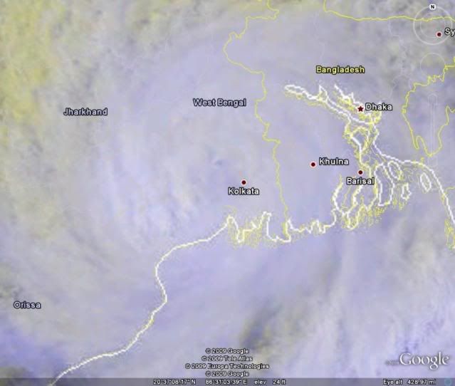
At 06:00 AM UTC, Cyclonic Storm Aila over northwest Bay of Bengal moved north-northeastwards intensified further into a severe cyclonic storm. Severe Cyclonic Storm Aila now lay centered over northwest Bay of Bengal near 21.5N 88.5E, close to southeast of Sagar Island.
Satellite imagery shows central dense overcast pattern of system. Current Dvorak intensity of the system is T3.5. Associated intense to very intense convection observed over the Bay of Bengal north of 14.5N and between 83.0E to 92.5E. The lowest cloud top temperature due to convection is about -70C around the system's center.
3 minute sustained winds near the center is 55 knots with gusts of 65 knots and a central pressure of 974 hPa.
Vertical wind shear of horizontal wind is between 10-15 knots around the system. Past 24 hours shear tendency is negative to the west and east of the system. The system lies close to the upper tropospheric ridge, which runs along 22.0N in association with the anticyclonic circulation over north Myanmar and adjoining northesat Bay of Bengal and Bangladesh located to the east-northeast of the system. There is an upper tropospheric trough in westerlies west to the system. Ses surface temperatures are warmer over north and central Bay of Bengal.
Storm surge of about 2-3 meters above astronomical tide is likely ito inudate coastal areas of West Bengal and adjoining Bangladesh at the time of landfall.
Considering all the above, the system is likely to maintain the same intensity and move in a near northerly direction and cross West Bengal-Bangladesh coast near 88.0E (near Sagat Island) between 0800 UTC and 1000 UTC, today. After landfall the system will weaken gradually due to land interaction.
Damage expected: Extensive damage to thatched roofs and huts, minor damage to power and communication lines due to uprooting of large avenue trees. Flooding of escape routs over coastal districts of West Bengal and north Orissa.
Advice and Action suggested: Total suspension of fishing operations. Coastal hutments dwellers to moved to safer place. People in affected areas to remain indoors.
Tropical Cyclone Warning Number THIRTEEN
SEVERE CYCLONIC STORM AILA (BOB02-2009)
11:30 AM IST May 25 2009
===============================
“Red Message”
Subject: Severe cyclonic storm crossing West Bengal coast.
At 06:00 AM UTC, Cyclonic Storm Aila over northwest Bay of Bengal moved north-northeastwards intensified further into a severe cyclonic storm. Severe Cyclonic Storm Aila now lay centered over northwest Bay of Bengal near 21.5N 88.5E, close to southeast of Sagar Island.
Satellite imagery shows central dense overcast pattern of system. Current Dvorak intensity of the system is T3.5. Associated intense to very intense convection observed over the Bay of Bengal north of 14.5N and between 83.0E to 92.5E. The lowest cloud top temperature due to convection is about -70C around the system's center.
3 minute sustained winds near the center is 55 knots with gusts of 65 knots and a central pressure of 974 hPa.
Vertical wind shear of horizontal wind is between 10-15 knots around the system. Past 24 hours shear tendency is negative to the west and east of the system. The system lies close to the upper tropospheric ridge, which runs along 22.0N in association with the anticyclonic circulation over north Myanmar and adjoining northesat Bay of Bengal and Bangladesh located to the east-northeast of the system. There is an upper tropospheric trough in westerlies west to the system. Ses surface temperatures are warmer over north and central Bay of Bengal.
Storm surge of about 2-3 meters above astronomical tide is likely ito inudate coastal areas of West Bengal and adjoining Bangladesh at the time of landfall.
Considering all the above, the system is likely to maintain the same intensity and move in a near northerly direction and cross West Bengal-Bangladesh coast near 88.0E (near Sagat Island) between 0800 UTC and 1000 UTC, today. After landfall the system will weaken gradually due to land interaction.
Damage expected: Extensive damage to thatched roofs and huts, minor damage to power and communication lines due to uprooting of large avenue trees. Flooding of escape routs over coastal districts of West Bengal and north Orissa.
Advice and Action suggested: Total suspension of fishing operations. Coastal hutments dwellers to moved to safer place. People in affected areas to remain indoors.
0 likes
I've never seen an IMD bulletin like that before. It looks re-written from an official bulletin. For example, IMD never specifies/has never specified the wind speed interval. Other obvious signs:
IMD (and most other agencies) never uses a colon to denote time. IMD officially references cyclone numbers with slashes (BOB 02/2009); and those =======s strongly yell out at me this isn't an official warning.
IMD (and most other agencies) never uses a colon to denote time. IMD officially references cyclone numbers with slashes (BOB 02/2009); and those =======s strongly yell out at me this isn't an official warning.
0 likes
-
HURAKAN
- Professional-Met
- Posts: 46086
- Age: 37
- Joined: Thu May 20, 2004 4:34 pm
- Location: Key West, FL
- Contact:
Re:
Chacor wrote:I've never seen an IMD bulletin like that before. It looks re-written from an official bulletin. For example, IMD never specifies/has never specified the wind speed interval. Other obvious signs:
IMD (and most other agencies) never uses a colon to denote time. IMD officially references cyclone numbers with slashes (BOB 02/2009); and those =======s strongly yell out at me this isn't an official warning.
I got from here. http://www.wunderground.com/blog/HadesG ... ntrynum=19
Didn't know it wasn't official, it looks official.
0 likes
-
HURAKAN
- Professional-Met
- Posts: 46086
- Age: 37
- Joined: Thu May 20, 2004 4:34 pm
- Location: Key West, FL
- Contact:

WTIO31 PGTW 251500
SUBJ: TROPICAL CYCLONE 02B (AILA) WARNING NR 006
1. TROPICAL CYCLONE 02B (AILA) WARNING NR 006
01 ACTIVE TROPICAL CYCLONE IN NORTHIO
MAX SUSTAINED WINDS BASED ON ONE-MINUTE AVERAGE
---
WARNING POSITION:
251200Z --- NEAR 22.9N 88.2E
MOVEMENT PAST SIX HOURS - 355 DEGREES AT 13 KTS
POSITION ACCURATE TO WITHIN 060 NM
POSITION BASED ON CENTER LOCATED BY A COMBINATION OF
SATELLITE AND SYNOPTIC DATA
PRESENT WIND DISTRIBUTION:
MAX SUSTAINED WINDS - 055 KT, GUSTS 070 KT
WIND RADII VALID OVER OPEN WATER ONLY
REPEAT POSIT: 22.9N 88.2E
---
FORECASTS:
12 HRS, VALID AT:
260000Z --- 24.8N 88.0E
MAX SUSTAINED WINDS - 040 KT, GUSTS 050 KT
WIND RADII VALID OVER OPEN WATER ONLY
DISSIPATING AS A SIGNIFICANT TROPICAL CYCLONE OVER LAND
VECTOR TO 24 HR POSIT: 015 DEG/ 07 KTS
---
24 HRS, VALID AT:
261200Z --- 26.2N 88.4E
MAX SUSTAINED WINDS - 025 KT, GUSTS 035 KT
WIND RADII VALID OVER OPEN WATER ONLY
DISSIPATED AS A SIGNIFICANT TROPICAL CYCLONE OVER LAND
---
REMARKS:
251500Z POSITION NEAR 23.4N 88.2E.
TROPICAL CYCLONE (TC) 02B (AILA), LOCATED APPROXIMATELY 25 NM NORTH-
NORTHWEST OF KOLKATA, INDIA, HAS TRACKED NORTHWARD AT 13 KNOTS OVER
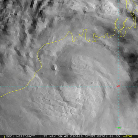
THE PAST SIX HOURS. ANIMATED MULTISPECTRAL SATELLITE IMAGERY AND A
251142Z AMSU IMAGE INDICATE THAT TC 02B HAS WEAKENED BUT HAS
MAINTAINED CORE CONVECTION AND GOOD CONVECTIVE BANDING, WHICH IS
WRAPPING INTO A WELL-DEFINED LOW-LEVEL CIRCULATION CENTER (LLCC).
THE CURRENT POSITION IS BASED ON THIS MICROWAVE IMAGE AS WELL AS
SYNOPTIC OBSERVATIONS FROM KOLKATA INDICATING EAST-SOUTHEASTERLY
SURFACE WINDS. THE CURRENT INTENSITY IS BASED ON THE SATELLITE
SIGNATURE AS WELL AS RECENT OBSERVATIONS SHOWING 38-50 KNOT WINDS
AND MINIMUM SLP VALUES OF 971 MB. THIS SLOW WEAKENING TREND WAS
ANTICIPATED DUE TO THE FLAT TERRAIN AND GOOD RADIAL OUTFLOW. THE
SYSTEM SHOULD GRADUALLY WEAKEN AND DISSIPATE BETWEEN TAU 12 AND 24
AS IT CONTINUES TRACKING NORTHWARD OVER LAND. THE MODEL GUIDANCE
REMAINS TIGHTLY CLUSTERED THROUGH THE FORECAST PERIOD SO THIS
FORECAST IS IN CLOSE AGREEMENT WITH THE MODEL CONSENSUS. MAXIMUM
SIGNIFICANT WAVE HEIGHT AT 251200Z IS 21 FEET. NEXT WARNINGS AT
252100Z, 260300Z AND 260900Z.
0 likes
Re: Bay of Bengal: Severe Cyclonic Storm AILA (02B)
Good thing that wasn't intense. It went right across Calcutta.
0 likes
-
senorpepr

- Military Met/Moderator

- Posts: 12542
- Age: 41
- Joined: Fri Aug 22, 2003 9:22 pm
- Location: Mackenbach, Germany
- Contact:
I'm not sure about the authenticity of that IMD report. I think it was based off of an actual report, but not officially from IMD.
Here's the latest Aila bulletin from IMD (http://www.imd.gov.in/section/nhac/dynamic/cwind.htm)
BOB 02/2009/15 Dated: 25. 05. 2009
Time of issue: 2000 hours IST
Sub: Severe cyclonic storm over Gangetic West Bengal.
The severe cyclonic storm “AILA” over Gangetic West Bengal Bengal moved slightly northward and lay centred at 1730 hours IST of today, the 25th May 2009 over Gangetic West Bengal close to Kolkata. The system is likely to move in a near northerly direction and weaken gradually.
Under its influence, rainfall at most places with heavy to very heavy falls at a few places and isolated extremely heavy falls (≥ 25 cm) is likely over Gangetic West Bengal during next 24 hours and over Sub-Himalayan West Bengal & Sikkim during next 48 hours.
Rain/thundershower is also likely at most places over Assam and Meghalaya with isolated heavy to very heavy fall during next 48 hours and over north Orissa during next 24 hrs.
Gale wind speed reaching 70-80 kmph gusting 90 kmph likely along and off West Bengal coasts during next 12 hours. Squally winds reaching 50-60 kmph gusting to 70 kmph likely along and off north Orissa coast during next 12 hours.
Sea condition will be very rough to high along and off West Bengal coast during next 12 hours. Fishermen are advised not to venture into sea.
Next bulletin will be issued at 2230 hrs IST of today, the 25th May 2009
...and the Special Tropical Weather Outlook from IMD pulled from the official WMO TC page (http://severe.worldweather.wmo.int/tc/in/)
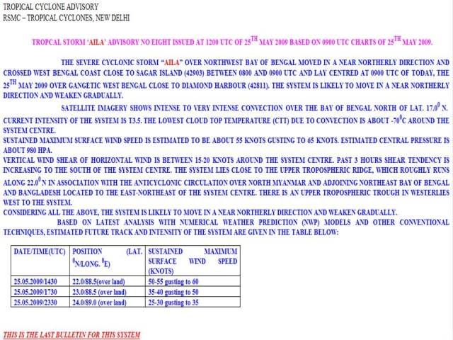
TROPICAL CYCLONE ADVISORY
RSMC – TROPICAL CYCLONES, NEW DELHI
TROPCAL STORM ‘AILA’ ADVISORY NO EIGHT ISSUED AT 1200 UTC OF 25TH MAY 2009 BASED ON 0900 UTC CHARTS OF 25TH MAY 2009.
THE SEVERE CYCLONIC STORM “AILA” OVER NORTHWEST BAY OF BENGAL MOVED IN A NEAR NORTHERLY DIRECTION AND CROSSED WEST BENGAL COAST CLOSE TO SAGAR ISLAND (42903) BETWEEN 0800 AND 0900 UTC AND LAY CENTRED AT 0900 UTC OF TODAY, THE 25TH MAY 2009 OVER GANGETIC WEST BENGAL CLOSE TO DIAMOND HARBOUR (42811). THE SYSTEM IS LIKELY TO MOVE IN A NEAR NORTHERLY DIRECTION AND WEAKEN GRADUALLY.
SATELLITE IMAGERY SHOWS INTENSE TO VERY INTENSE CONVECTION OVER THE BAY OF BENGAL NORTH OF LAT. 17.00 N. CURRENT INTENSITY OF THE SYSTEM IS T3.5. THE LOWEST CLOUD TOP TEMPERATURE (CTT) DUE TO CONVECTION IS ABOUT -700C AROUND THE SYSTEM CENTRE.
sustained maximum SURFACE wind speed is estimated to be about 55 KNOTS gusting to 65 knots. estimated CENTRAL pressure is about 980 hpa.
VERTICAL WIND SHEAR OF HORIZONTAL WIND IS BETWEEN 15-20 KNOTS AROUND THE SYSTEM CENTRE. PAST 3 HOURS SHEAR TENDENCY IS INCREASING TO THE SOUTH OF THE SYSTEM CENTRE. THE SYSTEM LIES CLOSE TO THE UPPER TROPOSPHERIC RIDGE, WHICH ROUGHLY RUNS ALONG 22.00 N IN ASSOCIATION WITH THE ANTICYCLONIC CIRCULATION OVER NORTH MYANMAR AND ADJOINING NORTHEAST BAY OF BENGAL AND BANGLADESH LOCATED TO THE EAST-NORTHEAST OF THE SYSTEM CENTRE. THERE IS AN UPPER TROPOSPHERIC TROUGH IN WESTERLIES WEST TO THE SYSTEM.
CONSIDERING ALL THE ABOVE, THE SYSTEM IS LIKELY TO MOVE IN A NEAR NORTHERLY DIRECTION AND WEAKEN GRADUALLY.
BASED ON LATEST ANALYSIS WITH NUMERICAL WEATHER PREDICTION (NWP) MODELS AND OTHER CONVENTIONAL TECHNIQUES, ESTIMATED FUTURE TRACK AND INTENSITY OF THE SYSTEM ARE GIVEN IN THE TABLE BELOW:
THIS IS THE LAST BULLETIN FOR THIS SYSTEM
Here's the latest Aila bulletin from IMD (http://www.imd.gov.in/section/nhac/dynamic/cwind.htm)
BOB 02/2009/15 Dated: 25. 05. 2009
Time of issue: 2000 hours IST
Sub: Severe cyclonic storm over Gangetic West Bengal.
The severe cyclonic storm “AILA” over Gangetic West Bengal Bengal moved slightly northward and lay centred at 1730 hours IST of today, the 25th May 2009 over Gangetic West Bengal close to Kolkata. The system is likely to move in a near northerly direction and weaken gradually.
Under its influence, rainfall at most places with heavy to very heavy falls at a few places and isolated extremely heavy falls (≥ 25 cm) is likely over Gangetic West Bengal during next 24 hours and over Sub-Himalayan West Bengal & Sikkim during next 48 hours.
Rain/thundershower is also likely at most places over Assam and Meghalaya with isolated heavy to very heavy fall during next 48 hours and over north Orissa during next 24 hrs.
Gale wind speed reaching 70-80 kmph gusting 90 kmph likely along and off West Bengal coasts during next 12 hours. Squally winds reaching 50-60 kmph gusting to 70 kmph likely along and off north Orissa coast during next 12 hours.
Sea condition will be very rough to high along and off West Bengal coast during next 12 hours. Fishermen are advised not to venture into sea.
Next bulletin will be issued at 2230 hrs IST of today, the 25th May 2009
...and the Special Tropical Weather Outlook from IMD pulled from the official WMO TC page (http://severe.worldweather.wmo.int/tc/in/)
TROPICAL CYCLONE ADVISORY
RSMC – TROPICAL CYCLONES, NEW DELHI
TROPCAL STORM ‘AILA’ ADVISORY NO EIGHT ISSUED AT 1200 UTC OF 25TH MAY 2009 BASED ON 0900 UTC CHARTS OF 25TH MAY 2009.
THE SEVERE CYCLONIC STORM “AILA” OVER NORTHWEST BAY OF BENGAL MOVED IN A NEAR NORTHERLY DIRECTION AND CROSSED WEST BENGAL COAST CLOSE TO SAGAR ISLAND (42903) BETWEEN 0800 AND 0900 UTC AND LAY CENTRED AT 0900 UTC OF TODAY, THE 25TH MAY 2009 OVER GANGETIC WEST BENGAL CLOSE TO DIAMOND HARBOUR (42811). THE SYSTEM IS LIKELY TO MOVE IN A NEAR NORTHERLY DIRECTION AND WEAKEN GRADUALLY.
SATELLITE IMAGERY SHOWS INTENSE TO VERY INTENSE CONVECTION OVER THE BAY OF BENGAL NORTH OF LAT. 17.00 N. CURRENT INTENSITY OF THE SYSTEM IS T3.5. THE LOWEST CLOUD TOP TEMPERATURE (CTT) DUE TO CONVECTION IS ABOUT -700C AROUND THE SYSTEM CENTRE.
sustained maximum SURFACE wind speed is estimated to be about 55 KNOTS gusting to 65 knots. estimated CENTRAL pressure is about 980 hpa.
VERTICAL WIND SHEAR OF HORIZONTAL WIND IS BETWEEN 15-20 KNOTS AROUND THE SYSTEM CENTRE. PAST 3 HOURS SHEAR TENDENCY IS INCREASING TO THE SOUTH OF THE SYSTEM CENTRE. THE SYSTEM LIES CLOSE TO THE UPPER TROPOSPHERIC RIDGE, WHICH ROUGHLY RUNS ALONG 22.00 N IN ASSOCIATION WITH THE ANTICYCLONIC CIRCULATION OVER NORTH MYANMAR AND ADJOINING NORTHEAST BAY OF BENGAL AND BANGLADESH LOCATED TO THE EAST-NORTHEAST OF THE SYSTEM CENTRE. THERE IS AN UPPER TROPOSPHERIC TROUGH IN WESTERLIES WEST TO THE SYSTEM.
CONSIDERING ALL THE ABOVE, THE SYSTEM IS LIKELY TO MOVE IN A NEAR NORTHERLY DIRECTION AND WEAKEN GRADUALLY.
BASED ON LATEST ANALYSIS WITH NUMERICAL WEATHER PREDICTION (NWP) MODELS AND OTHER CONVENTIONAL TECHNIQUES, ESTIMATED FUTURE TRACK AND INTENSITY OF THE SYSTEM ARE GIVEN IN THE TABLE BELOW:
Code: Select all
DATE/TIME(UTC)      POSITION (LAT. 0N/LONG. 0E)    SUSTAINED MAXIMUM SURFACE WIND SPEED (KNOTS)

25.05.2009/1430     22.0/88.5(over land)           50-55 gusting to 60

25.05.2009/1730     23.0/88.5 (over land)          35-40 gusting to 50

25.05.2009/2330     24.0/89.0 (over land)          25-30 gusting to 35
THIS IS THE LAST BULLETIN FOR THIS SYSTEM
0 likes

-
Derek Ortt
-
Category 5

- Category 5

- Posts: 10074
- Age: 34
- Joined: Sun Feb 11, 2007 10:00 pm
- Location: New Brunswick, NJ
- Contact:
Re:
Derek Ortt wrote:Wikipedia is saying 48 dead and 1,000 missing
http://en.wikipedia.org/wiki/Cyclone_Aila
Since its wikipedia I take this with a grain of salt but I would not be surprised.
0 likes
-
cycloneye

- Admin

- Posts: 139086
- Age: 67
- Joined: Thu Oct 10, 2002 10:54 am
- Location: San Juan, Puerto Rico
Re: Bay of Bengal: Severe Cyclonic Storm AILA (02B)
Cyclone Aila kills nearly 120 in Bangladesh, India
DHAKA (Reuters) – Nearly 120 people have been killed by a cyclone that ripped through Bangladesh and eastern India, officials and local media said on Tuesday, while millions remained marooned by floodwaters or living in shelters.
The death toll in Bangladesh rose to at least 89 following recovery of more bodies on Tuesday, the Daily Star newspaper said in its online edition, while Indian officials said at least 29 people had died in West Bengal state.
Cyclone Aila slammed into parts of coastal Bangladesh and eastern India on Monday, triggering tidal surges and flooding that forced half a million people from their homes.
Officials in Bangladesh moved about 500,000 people to temporary shelters after they left their homes to escape huge tidal waves churned by winds up to 100 kph (60 mph).
Heavy rain triggered by the storm also raised river levels and burst mud embankments in the Sundarbans delta in the neighboring eastern Indian state of West Bengal.
The affected area is home to hundreds of thousands of people as well as the world's biggest tiger reserve.
In Bangladesh, the worst affected area was the Satkhira district, near the port of Mongla, where a local official said 17 bodies were found in one village.
"The situation here is alarming, and the confirmed death toll so far in the district is 23. But it may go up," Mohammad Abdus Samad, deputy commissioner of Satkhira, told Reuters by telephone.
Aila swept many areas still recovering from Cyclone Sidr in November 2007, which killed 3,500 people in Bangladesh and made at least a million homeless.
MISSING
Bangladesh officials said at least 100 people were missing after Monday's cyclone.
Some aid workers, requesting not to be identified, said they feared several hundred people might have been killed by Aila, which followed a less lethal cyclone, Bijli, that killed only a few people in April.
Army, navy and coast guards were helping civil officials and volunteers to search for the missing and pick up people marooned in hundreds of villages, caught in chest or shoulder-high waters, witnesses said.
In West Bengal, the Indian army and government aid workers on Tuesday began an operation to provide relief to more than 400,000 people marooned in the Sundarbans delta region.
Officials in West Bengal said at least 29 people died in the cyclone, mostly from house collapses, electrocution and falling trees.
"We have moved two columns, each with 100 personnel, to Sundarbans for relief," said Mahesh Upasani, a defense spokesman.
Large areas of crops were destroyed in both countries by the cyclone, officials said, adding they were assessing the damage.
Cargo handling at Paradeep port in India's eastern state of Orissa returned to normal after being severely affected for the past two days, K.Raghuramaiah, chairman of Paradeep Port Trust, told Reuters.
Many farmers have lost their rice just ready to be harvested. "Allah has taken it (rice and other crops) all from me. I have been made a pauper," said Mohar Ali, a farmer.
http://news.yahoo.com/s/nm/20090526/wl_ ... bangladesh
0 likes
-
HURAKAN
- Professional-Met
- Posts: 46086
- Age: 37
- Joined: Thu May 20, 2004 4:34 pm
- Location: Key West, FL
- Contact:
More than 155 dead and at least half a million people homeless.
http://news.bbc.co.uk/1/hi/world/south_asia/8067618.stm
http://news.bbc.co.uk/1/hi/world/south_asia/8067618.stm
0 likes
Re: Bay of Bengal: Severe Cyclonic Storm AILA (02B)
I've visited that area of India. Many people live in little corrugated tin and stick huts made out of any material they can scrap up. It isn't surprising Alia killed people even though it was fairly mild in comparison to Bay Of Bengal cyclones. The third world makes the US look like some kind of utopia.
0 likes
Who is online
Users browsing this forum: No registered users and 135 guests