
Guess I was right after all. The recon was cancelled:
000
ABNT20 KNHC 271734
TWOAT
SPECIAL TROPICAL WEATHER OUTLOOK
NWS TPC/NATIONAL HURRICANE CENTER MIAMI FL
130 PM EDT WED MAY 27 2009
FOR THE NORTH ATLANTIC...CARIBBEAN SEA AND THE GULF OF MEXICO...
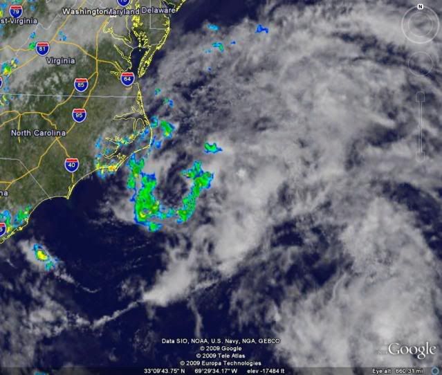
THE AREA OF LOW PRESSURE CENTERED ABOUT 75 MILES SOUTH-SOUTHEAST OF
CAPE HATTERAS NORTH CAROLINA HAS CHANGED LITTLE TODAY. CONDITIONS
ARE NOT FAVORABLE FOR SIGNIFICANT DEVELOPMENT...AND THE OPPORTUNITY
FOR THE SYSTEM TO BECOME A TROPICAL CYCLONE BEFORE REACHING COLDER
OCEAN WATERS IS DIMINISHING. SHOWERS FROM THIS SYSTEM ARE
CURRENTLY AFFECTING COASTAL NORTH CAROLINA. AS THE AREA OF LOW
PRESSURE MOVES TOWARD THE NORTH OR NORTHEAST AT 10-15 MPH...THE
SYSTEM WILL CONTINUE TO BRING SOME SHOWERS TO THE AREA FOR THE
REMAINDER OF TODAY. THERE IS A LOW CHANCE...LESS THAN 30 PERCENT...
OF THIS SYSTEM BECOMING A TROPICAL CYCLONE DURING THE NEXT 48
HOURS. THE AIR FORCE RECONNAISSANCE MISSION SCHEDULED FOR THIS
AFTERNOON HAS BEEN CANCELED. AN ADDITIONAL SPECIAL TROPICAL
WEATHER OUTLOOK WILL BE ISSUED AT 8 PM EDT. SEE LOCAL WEATHER
FORECAST OFFICE PRODUCTS FOR ADDITIONAL INFORMATION ON THIS SYSTEM.
$$
FORECASTER LANDSEA/FRANKLIN
EAST COAST : Tropical Depression ONE
Moderator: S2k Moderators
Re: East Coast : INVEST 91L
0 likes
-
wxman57

- Moderator-Pro Met

- Posts: 22482
- Age: 66
- Joined: Sat Jun 21, 2003 8:06 pm
- Location: Houston, TX (southwest)
Re:
capepoint wrote:should be very near 41036 right now.
Actually, it passed 150 miles east of 41036 and is now about 65 miles SSE of buoy 41025. The buoy has been reporting an easterly wind at 10 kts and 1011.3mb. Buoy 41036 150 miles to the WSW has a NW wind of 5 kts. As Derek said, just a low-level swirl at this point. Development chances slim. Even the Gulf Stream is too cool to support development so far north so early in the season.
0 likes


-
wxman57
- Moderator-Pro Met
- Posts: 22482
- Age: 66
- Joined: Sat Jun 21, 2003 8:06 pm
- Location: Houston, TX (southwest)
Re: East Coast : INVEST 91L
Here's a map with surface plots. Just a weak eddy with 5-10 kts around the center:

0 likes
Re: East Coast : INVEST 91L
strongest winds are probably on the N'eastern and S'eastern side of the low....no obs there....probably 25 mph.....
0 likes
-
wxman57
- Moderator-Pro Met
- Posts: 22482
- Age: 66
- Joined: Sat Jun 21, 2003 8:06 pm
- Location: Houston, TX (southwest)
Re: East Coast : INVEST 91L
cpdaman wrote:strongest winds are probably on the N'eastern and S'eastern side of the low....no obs there....probably 25 mph.....
Just got a ship report on the eastern side of the center - Wind about 150 deg at 15 kts. It's in an area of heavier showers, too. Bones is walking up to the microphone...
0 likes
-
wxman57
- Moderator-Pro Met
- Posts: 22482
- Age: 66
- Joined: Sat Jun 21, 2003 8:06 pm
- Location: Houston, TX (southwest)
Re: East Coast : INVEST 91L
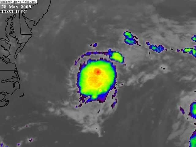
Looks like it's made the turn to the NE. Wind shear is on the increase. Convection is decreasing (if that's possible), and water cooler and cooler. This one's dead...

0 likes
-
srainhoutx

- S2K Supporter

- Posts: 6919
- Age: 66
- Joined: Sun Jan 14, 2007 11:34 am
- Location: Haywood County, NC
- Contact:
Re: East Coast : INVEST 91L
I bet the complex that came off TX kept some folks hoping today more than 91L. 
0 likes
-
cycloneye

- Admin

- Posts: 139140
- Age: 67
- Joined: Thu Oct 10, 2002 10:54 am
- Location: San Juan, Puerto Rico
Re: East Coast : INVEST 91L
Bones,you can come now!
253
ABNT20 KNHC 272348
TWOAT
SPECIAL TROPICAL WEATHER OUTLOOK
NWS TPC/NATIONAL HURRICANE CENTER MIAMI FL
745 PM EDT WED MAY 27 2009
FOR THE NORTH ATLANTIC...CARIBBEAN SEA AND THE GULF OF MEXICO...
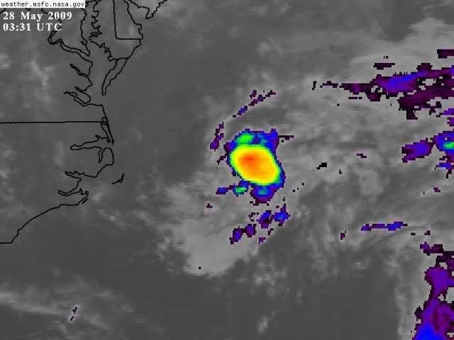
SHOWER ACTIVITY ASSOCIATED WITH THE AREA OF LOW PRESSURE CENTERED
ABOUT 90 MILES EAST-SOUTHEAST OF CAPE HATTERAS NORTH CAROLINA IS
DECREASING. THE LOW IS EXPECTED TO MOVE GENERALLY NORTHEASTWARD
AWAY FROM THE COAST AROUND 15 MPH OVER THE NEXT OR SO. CONDITIONS
ARE NOT FAVORABLE FOR SIGNIFICANT DEVELOPMENT...AND THE OPPORTUNITY
FOR THE SYSTEM TO BECOME A TROPICAL CYCLONE BEFORE REACHING COOLER
OCEAN WATERS CONTINUES TO DIMINISH. THERE IS A LOW CHANCE...LESS
THAN 30 PERCENT...OF THIS SYSTEM BECOMING A TROPICAL CYCLONE DURING
THE NEXT 48 HOURS.
NO ADDITIONAL SPECIAL TROPICAL WEATHER OUTLOOKS ARE ANTICIPATED FOR
THIS SYSTEM. SEE NATIONAL WEATHER SERVICE FORECAST OFFICE PRODUCTS
FOR ADDITIONAL INFORMATION.
$$
FORECASTER BERG/PASCH
253
ABNT20 KNHC 272348
TWOAT
SPECIAL TROPICAL WEATHER OUTLOOK
NWS TPC/NATIONAL HURRICANE CENTER MIAMI FL
745 PM EDT WED MAY 27 2009
FOR THE NORTH ATLANTIC...CARIBBEAN SEA AND THE GULF OF MEXICO...
SHOWER ACTIVITY ASSOCIATED WITH THE AREA OF LOW PRESSURE CENTERED
ABOUT 90 MILES EAST-SOUTHEAST OF CAPE HATTERAS NORTH CAROLINA IS
DECREASING. THE LOW IS EXPECTED TO MOVE GENERALLY NORTHEASTWARD
AWAY FROM THE COAST AROUND 15 MPH OVER THE NEXT OR SO. CONDITIONS
ARE NOT FAVORABLE FOR SIGNIFICANT DEVELOPMENT...AND THE OPPORTUNITY
FOR THE SYSTEM TO BECOME A TROPICAL CYCLONE BEFORE REACHING COOLER
OCEAN WATERS CONTINUES TO DIMINISH. THERE IS A LOW CHANCE...LESS
THAN 30 PERCENT...OF THIS SYSTEM BECOMING A TROPICAL CYCLONE DURING
THE NEXT 48 HOURS.
NO ADDITIONAL SPECIAL TROPICAL WEATHER OUTLOOKS ARE ANTICIPATED FOR
THIS SYSTEM. SEE NATIONAL WEATHER SERVICE FORECAST OFFICE PRODUCTS
FOR ADDITIONAL INFORMATION.
$$
FORECASTER BERG/PASCH
0 likes
-
Tampa Bay Hurricane

- Category 5

- Posts: 5594
- Age: 36
- Joined: Fri Jul 22, 2005 7:54 pm
- Location: St. Petersburg, FL
Re: East Coast : INVEST 91L
Another season with ghost systems early on. Last year had ghost systems and you know what followed.
0 likes
Re: East Coast : INVEST 91L
2009, maybe the year of too little, too late? We are two for two.

0 likes

I'll second the motion for the next invest to be in september. All in favor......
Seriously tho....
A question to you pro-mets and experienced amatures....
I read somewhere that it seems that the models did correctly indicate the start-up of these two lows, but I dont know if they are also giving false alarms. I seem to remember last year the models giving several false alarms that never materialized. Could it be that the models are doing better this year, or have I just not been paying much attention.
thanks
0 likes
Who is online
Users browsing this forum: No registered users and 79 guests