Jeff Masters:
http://www.wunderground.com/blog/JeffMa ... rynum=1230
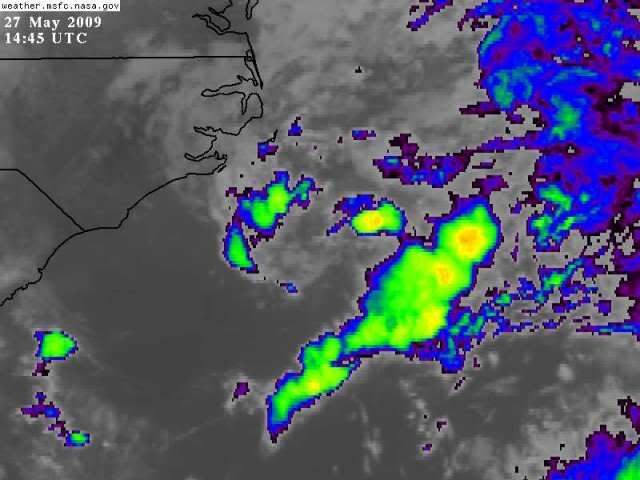
An area of disturbed weather, dubbed "91L" by the National Hurricane Center, is centered 120 miles south of Cape Hatteras, North Carolina. While the storm does not have much in the way of heavy thunderstorm activity, it does have a well-developed circulation, and the spin of the system is readily apparent on long range radar animations out of Morehead City, North Carolina. The disturbance is over waters of 25 - 26°C and has wind shear of 10 - 15 knots over it, and these conditions are marginally favorable for some slow development to occur until Thursday afternoon, when the system will begin moving over waters too cold to support tropical cyclone development. The disturbance will track north or north-northeastward at 10 - 15 mph towards North Carolina's Outer Banks today, then get swept northeastwards out to sea on Thursday. It is unlikely that the disturbance has enough time to develop into a tropical depression, but an Air Force hurricane hunter flight is on call to investigate the system this afternoon, if necessary. If the system does develop, the current location of the heaviest thunderstorm activity in a band well removed from the center suggests that 91L would be classified as a subtropical depression. The Outer Banks of North Carolina can expect 20 - 25 mph winds and heavy rain from this system tonight and Thursday morning. In a Special Tropical Weather Outlook issued at 8am EDT this morning, NHC gave 91L a low (less than 30% chance) of developing into a tropical depression.
-snip-
EAST COAST : Tropical Depression ONE
Moderator: S2k Moderators
-
tolakram
- Admin

- Posts: 19165
- Age: 60
- Joined: Sun Aug 27, 2006 8:23 pm
- Location: Florence, KY (name is Mark)
Re: East Coast : INVEST 91L
0 likes
It's bad English, but - there ain't nothin' there!
http://www.goes.noaa.gov/browsh.html
perhaps a weak surface low, at best, but per the late Director of the HRD, if he looked at this photo, he'd tell me:
"Go home, Frank!"
P.S. My first denial of the 2009 season (LOL)...
http://www.goes.noaa.gov/browsh.html
perhaps a weak surface low, at best, but per the late Director of the HRD, if he looked at this photo, he'd tell me:
"Go home, Frank!"
P.S. My first denial of the 2009 season (LOL)...
0 likes


Re: East Coast : INVEST 91L
Well, I was wrong 
00
NOUS42 KNHC 271500
WEATHER RECONNAISSANCE FLIGHTS
CARCAH, NATIONAL HURRICANE CENTER, MIAMI, FL.
1100 AM EDT WED 27 MAY 2009
SUBJECT: TROPICAL CYCLONE PLAN OF THE DAY (TCPOD)
VALID 28/1100Z TO 29/1100Z MAY 2009
WSPOD NUMBER.....09-003
I. ATLANTIC REQUIREMENTS
1. NEGATIVE RECONNAISSANCE REQUIREMENTS.
2. SUCCEEDING DAY OUTLOOK.....NEGATIVE.
3. NOTE: THE MISSION SCHEDULED FOR 27/2100Z OFF NORTH
CAROLINA WILL FLY TODAY, BUT THE SECOND AT 28/06Z
WAS CANX.
0 likes
-
cycloneye

- Admin
- Posts: 139137
- Age: 67
- Joined: Thu Oct 10, 2002 10:54 am
- Location: San Juan, Puerto Rico
Re: Recon : INVEST 91L
Plane will fly this afternoon
000
NOUS42 KNHC 271500
WEATHER RECONNAISSANCE FLIGHTS
CARCAH, NATIONAL HURRICANE CENTER, MIAMI, FL.
1100 AM EDT WED 27 MAY 2009
SUBJECT: TROPICAL CYCLONE PLAN OF THE DAY (TCPOD)
VALID 28/1100Z TO 29/1100Z MAY 2009
WSPOD NUMBER.....09-003
I. ATLANTIC REQUIREMENTS
1. NEGATIVE RECONNAISSANCE REQUIREMENTS.
2. SUCCEEDING DAY OUTLOOK.....NEGATIVE.
3. [b]NOTE: THE MISSION SCHEDULED FOR 27/2100Z OFF NORTH
CAROLINA WILL FLY TODAY, BUT THE SECOND AT 28/06Z
WAS CANX.
[/b]
http://www.nhc.noaa.gov/text/MIAREPRPD.shtml?
0 likes
-
wxman57

- Moderator-Pro Met

- Posts: 22482
- Age: 66
- Joined: Sat Jun 21, 2003 8:06 pm
- Location: Houston, TX (southwest)
Re: East Coast : INVEST 91L
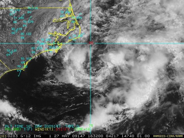
Definitely a closed LLC today, but winds around the center are only in the 10-15 kt range and convection is minimal. It's moving over cooler and cooler water now, and wind shear is a bit of a factor as well. Slim chance of development.
0 likes
-
Ed Mahmoud
Re: Recon : INVEST 91L
If this is a 1983 or 1997 type season, as the oncoming El Neenyo suggests, they won't get too many opportunities to practice flying through real, well, sort of real, disturbances.
But think of all the jet fuel they'll save.
I hope the research people don't have any grand Project Vortex like experiments planned this summer. The Spring tour is probably the most air time the Orions will see this year.
But think of all the jet fuel they'll save.
I hope the research people don't have any grand Project Vortex like experiments planned this summer. The Spring tour is probably the most air time the Orions will see this year.
0 likes
Re: East Coast : INVEST 91L
Makes me wonder if their numbers prediction is low for this year?
0 likes
-
tolakram
- Admin
- Posts: 19165
- Age: 60
- Joined: Sun Aug 27, 2006 8:23 pm
- Location: Florence, KY (name is Mark)
Re: East Coast : INVEST 91L
Not sure what to make of this. The center may be very close or crossing this buoy.
http://www.ndbc.noaa.gov/station_page.php?station=41025
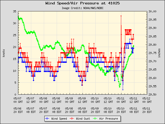
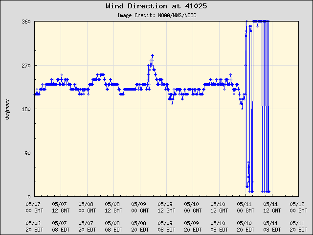
http://www.ndbc.noaa.gov/station_page.php?station=41025
0 likes
-
hurricanefloyd5

- Category 5

- Posts: 1659
- Age: 43
- Joined: Sun May 02, 2004 10:53 am
- Location: Spartanburg
- Contact:
Re: Model Guidance : INVEST 91L
are all or most of the models showing at lease ANA of 35kts or is this just a few models???
0 likes


-
Tampa Bay Hurricane

- Category 5
- Posts: 5594
- Age: 36
- Joined: Fri Jul 22, 2005 7:54 pm
- Location: St. Petersburg, FL
Re: East Coast : INVEST 91L
OpieStorm wrote:In my 15+ years of tracking tropical cyclones I never knew that 2 areas of thunderstomrs in May meant we were on pace to a hyperactive season.Interesting.
The two areas were close to being named...well defined Low Level Centers...so we were close to 2 systems...
hyperactive for May.
0 likes


Who is online
Users browsing this forum: No registered users and 60 guests