NE of Azores Islands : INVEST 92L

Moderator: S2k Moderators

Message
Author
User avatar
Category 5
Category 5
Category 5
Posts: 10074
Age: 34
Joined: Sun Feb 11, 2007 10:00 pm
Location: New Brunswick, NJ
Contact:

Re: NE of Azores Islands : INVEST 92L

#81 Postby Category 5 » Tue Jun 02, 2009 3:33 pm

hurricanefloyd5 wrote:
Macrocane wrote:I still don't understand why it hasn't been named. It has a close circulation, the convection is weak but I have seen other tropical systems with the same appearence due to high latitudes, it's not cold core and it is producing winds higher than 35 kt. For me is at least subtropical, maybe we will have to wait until post analysis.

this is ANA with an eye in my opinion


http://www.ssd.noaa.gov/goes/flt/t1/loop-rb.html


If I had to guess thats not a "true eye"
0 likes   

Derek Ortt

#82 Postby Derek Ortt » Tue Jun 02, 2009 3:35 pm

if I were making the call, this would be a Tropical Storm

This is a classic TC underneath a UL, which is a very favorable location for development as we have little shear and very cold UL temps. Almost impossible to get a major out of this, but we can see development up to cat 1 in this environment (see Vince, Olga, Michael and a few others)
0 likes   

User avatar
Category 5
Category 5
Category 5
Posts: 10074
Age: 34
Joined: Sun Feb 11, 2007 10:00 pm
Location: New Brunswick, NJ
Contact:

Re: NE of Azores Islands : INVEST 92L

#83 Postby Category 5 » Tue Jun 02, 2009 3:41 pm

I spy a 50kt barb near the center

Image
0 likes   

User avatar
hurricanefloyd5
Category 5
Category 5
Posts: 1659
Age: 43
Joined: Sun May 02, 2004 10:53 am
Location: Spartanburg
Contact:

Re: NE of Azores Islands : INVEST 92L

#84 Postby hurricanefloyd5 » Tue Jun 02, 2009 3:41 pm

call the NHC and ask why they are not naming this system LOL
0 likes   

User avatar
Category 5
Category 5
Category 5
Posts: 10074
Age: 34
Joined: Sun Feb 11, 2007 10:00 pm
Location: New Brunswick, NJ
Contact:

Re: NE of Azores Islands : INVEST 92L

#85 Postby Category 5 » Tue Jun 02, 2009 3:42 pm

I would be curious as to why. The quikscat shows a fully tropical system. It has persisted and has TS winds.
Last edited by Category 5 on Tue Jun 02, 2009 3:44 pm, edited 1 time in total.
0 likes   

User avatar
HURAKAN
Professional-Met
Professional-Met
Posts: 46086
Age: 37
Joined: Thu May 20, 2004 4:34 pm
Location: Key West, FL
Contact:

#86 Postby HURAKAN » Tue Jun 02, 2009 3:44 pm

Looking at the flip side, it will be soooo weird to name a system over 44ºN!!!

That's unheard of. That's why the tropics are so fun!!!
0 likes   

User avatar
cycloneye
Admin
Admin
Posts: 139051
Age: 67
Joined: Thu Oct 10, 2002 10:54 am
Location: San Juan, Puerto Rico

Re: NE of Azores Islands : INVEST 92L

#87 Postby cycloneye » Tue Jun 02, 2009 3:44 pm

Image
0 likes   

User avatar
Category 5
Category 5
Category 5
Posts: 10074
Age: 34
Joined: Sun Feb 11, 2007 10:00 pm
Location: New Brunswick, NJ
Contact:

Re:

#88 Postby Category 5 » Tue Jun 02, 2009 3:44 pm

HURAKAN wrote:Looking at the flip side, it will be soooo weird to name a system over 44ºN!!!

That's unheard of. That's why the tropics are so fun!!!


Something likes this in June is quite ridiculous.
0 likes   

User avatar
HURAKAN
Professional-Met
Professional-Met
Posts: 46086
Age: 37
Joined: Thu May 20, 2004 4:34 pm
Location: Key West, FL
Contact:

#89 Postby HURAKAN » Tue Jun 02, 2009 3:57 pm

Image

Image

Light is coming down.
0 likes   

User avatar
MGC
S2K Supporter
S2K Supporter
Posts: 5792
Joined: Sun Mar 23, 2003 9:05 pm
Location: Pass Christian MS, or what is left.

Re: NE of Azores Islands : INVEST 92L

#90 Postby MGC » Tue Jun 02, 2009 4:04 pm

Very impressive system considering how far north it is. Almost looks tropical with convection so close to the center. I don't agree with naming subtropical systems though but that is the NHC call.....MGC
0 likes   

CrazyC83
Professional-Met
Professional-Met
Posts: 33393
Joined: Tue Mar 07, 2006 11:57 pm
Location: Deep South, for the first time!

#91 Postby CrazyC83 » Tue Jun 02, 2009 4:13 pm

Could this be the second unnamed storm already? (The Gulf low is also debatable on whether that was a tropical storm)

I'd guess at least 50 kt, maybe 55 kt, and I'd say it is a tropical storm.
Last edited by CrazyC83 on Tue Jun 02, 2009 4:15 pm, edited 1 time in total.
0 likes   

User avatar
DanieleItalyRm
Category 1
Category 1
Posts: 486
Age: 38
Joined: Mon Sep 22, 2008 7:52 am
Location: Rome - Italy - Mediterranean sea

#92 Postby DanieleItalyRm » Tue Jun 02, 2009 4:15 pm

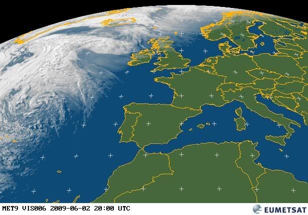
I have noticed that the nhc tends to classify systems as tropical sistem very easily.. Apparently it is less willing in giving the same classification to east atlantic systems..
If the current system had occured over the USA coast it would have been classified as tropical storm already.
Today the tropical caracteristics and tropical storm intensity are already there.
I am sure that they are waiting for it dissipation so they wont need to give it a name.

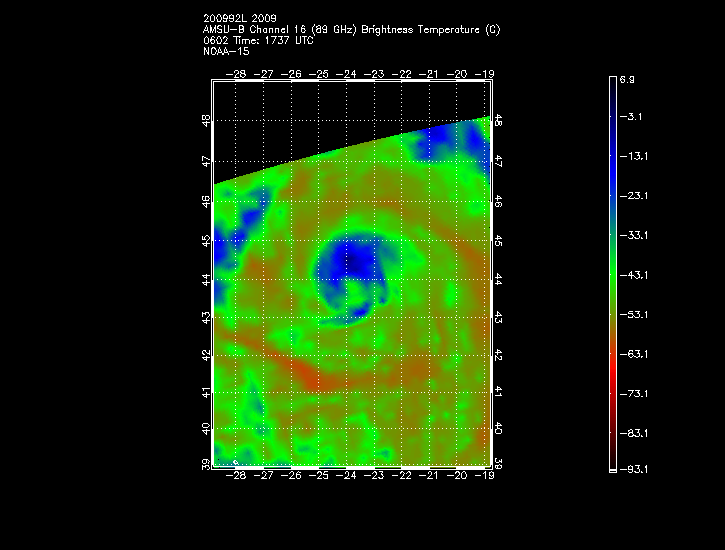
example of cold core derived:

Grace:An extratropical low formed just north of Hispaniola on October 15, and the next day gained enough tropical characteristics to be classified as a tropical storm.

Ivan was an unusual storm, forming from an extratropical system that had been tracked off the coast of Portugal since late September. The extratropical storm moved erratically southwest past the Azores, slowly acquiring tropical characteristics. On October 4, the system became a named tropical storm.

A large extratropical low formed off the southeastern coast of the United States on November 21. The low moved away from the coast, and a convective cloud mass began forming near the low's center. By November 25, the cloud mass showed distinct signs of being a tropical system, and when its intensity was estimated at hurricane strength

A cold-core upper level low induced the formation of a surface low over the subtropical Atlantic Ocean in early October. It developed enough organized convection to be classified a subtropical depression on October 15, and became a subtropical storm the next day. A warm core developed, and it was re-classified as Tropical Storm Michael

Image
0 likes   

User avatar
somethingfunny
ChatStaff
ChatStaff
Posts: 3926
Age: 35
Joined: Thu May 31, 2007 10:30 pm
Location: McKinney, Texas

#93 Postby somethingfunny » Tue Jun 02, 2009 4:33 pm

I prefer this newer policy, where a TC needs to fit a stricter definition and show consistency and potential to continue strengthening before it's named (this is what they used to do in the 50s, 60s, 70s, and 80s)... ... However it's opening a can of worms regarding the legitimacy and consitency of recordkeeping in the basin.

It seems apparent to me that there's been some sort of political shift at the NHC regarding how easily they'll name a system. If we were following the same standards that were followed during the year of Bret, Gert, Lee, Vince, Delta, Epsilon, and Zeta, this would likely have been named Claudette by now.

At this point, I don't think it'll be Ana either. No land areas threatened, and shipping interests wouldn't know the difference between a 50kt tropical storm and a 50kt cold-core storm....they just know to avoid it.
0 likes   

tolakram
Admin
Admin
Posts: 19165
Age: 60
Joined: Sun Aug 27, 2006 8:23 pm
Location: Florence, KY (name is Mark)

Re: NE of Azores Islands : INVEST 92L

#94 Postby tolakram » Tue Jun 02, 2009 4:33 pm

Either you follow a scientific rule and name systems that qualify or you just make stuff up and lose credibility. In my opinion of course.

So what defines a tropical system and how many definitions are needed to call it tropical?

SST in a certain range?
Warm Core?
Winds at the surface above a certain speed?
Anything else?

If the rule says all must be met then this is not a tropical system, otherwise it is. :)
0 likes   

User avatar
brunota2003
S2K Supporter
S2K Supporter
Posts: 9476
Age: 33
Joined: Sat Jul 30, 2005 9:56 pm
Location: Stanton, KY...formerly Havelock, NC
Contact:

Re: NE of Azores Islands : INVEST 92L

#95 Postby brunota2003 » Tue Jun 02, 2009 4:44 pm

Category 5 wrote:I spy a 50kt barb near the center

Image

That barb is black too, suggesting rain contamination.
0 likes   

User avatar
DanieleItalyRm
Category 1
Category 1
Posts: 486
Age: 38
Joined: Mon Sep 22, 2008 7:52 am
Location: Rome - Italy - Mediterranean sea

Re: NE of Azores Islands : INVEST 92L

#96 Postby DanieleItalyRm » Tue Jun 02, 2009 4:57 pm

brunota2003 wrote:That barb is black too, suggesting rain contamination.


enlarge the last quickscat image..this is 40-50 knots winds..

Image

Image
0 likes   

User avatar
cycloneye
Admin
Admin
Posts: 139051
Age: 67
Joined: Thu Oct 10, 2002 10:54 am
Location: San Juan, Puerto Rico

Re: NE of Azores Islands : INVEST 92L

#97 Postby cycloneye » Tue Jun 02, 2009 5:05 pm

Image
0 likes   

User avatar
Category 5
Category 5
Category 5
Posts: 10074
Age: 34
Joined: Sun Feb 11, 2007 10:00 pm
Location: New Brunswick, NJ
Contact:

Re: NE of Azores Islands : INVEST 92L

#98 Postby Category 5 » Tue Jun 02, 2009 5:37 pm

If I may paraphrase the NHC a bit.

If it looks like a tropical storm, it probably is, despite its environment and unusual location. :lol:
0 likes   

User avatar
cycloneye
Admin
Admin
Posts: 139051
Age: 67
Joined: Thu Oct 10, 2002 10:54 am
Location: San Juan, Puerto Rico

Re: NE of Azores Islands : INVEST 92L

#99 Postby cycloneye » Tue Jun 02, 2009 6:08 pm

Here is a microwave at 1:37 PM EDT or 17:37 UTC.

Image
0 likes   

User avatar
hurricanefloyd5
Category 5
Category 5
Posts: 1659
Age: 43
Joined: Sun May 02, 2004 10:53 am
Location: Spartanburg
Contact:

Re: NE of Azores Islands : INVEST 92L

#100 Postby hurricanefloyd5 » Tue Jun 02, 2009 6:20 pm

cycloneye wrote:Here is a microwave at 1:37 PM EDT or 17:37 UTC.

Image


oh brother a hurricane with no name LOL jUST KIDDING
0 likes   


Return to “2009”

Who is online

Users browsing this forum: No registered users and 56 guests