BEGIN
NHC_ATCF
invest_al922009.invest
FSTDA
R
U
040
010
0000
200906020137
NONE
NOTIFY=ATRP
END
INVEST, AL, L, , , , , 92, 2009, DB, O, 2009060200, 9999999999, , , , , , METWATCH, , AL922009
AL, 92, 2009060100, , BEST, 0, 384N, 280W, 30, 1004, EX, 0, , 0, 0, 0, 0,
AL, 92, 2009060106, , BEST, 0, 387N, 263W, 30, 1003, EX, 0, , 0, 0, 0, 0,
AL, 92, 2009060112, , BEST, 0, 392N, 255W, 30, 1001, EX, 0, , 0, 0, 0, 0,
AL, 92, 2009060118, , BEST, 0, 401N, 247W, 35, 1001, EX, 34, NEQ, 50, 50, 0, 0,
AL, 92, 2009060200, , BEST, 0, 408N, 242W, 35, 1001, EX, 34, NEQ, 50, 50, 0, 0,
ftp://ftp.tpc.ncep.noaa.gov/atcf/tcweb/
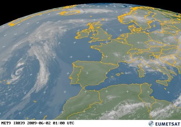
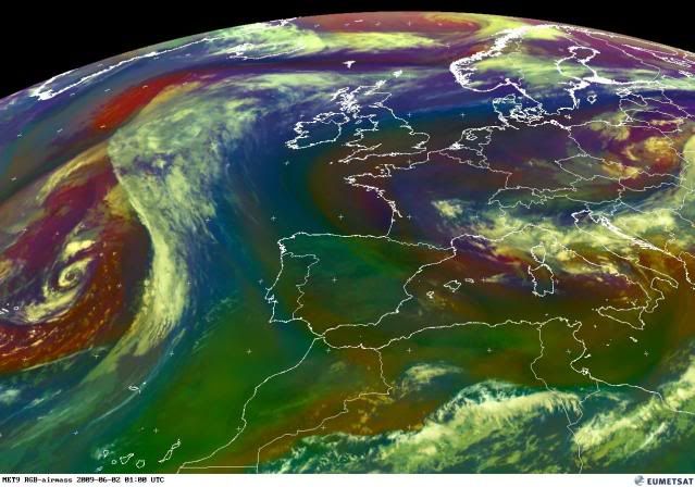
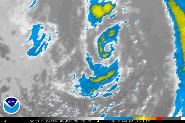
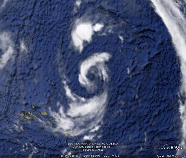
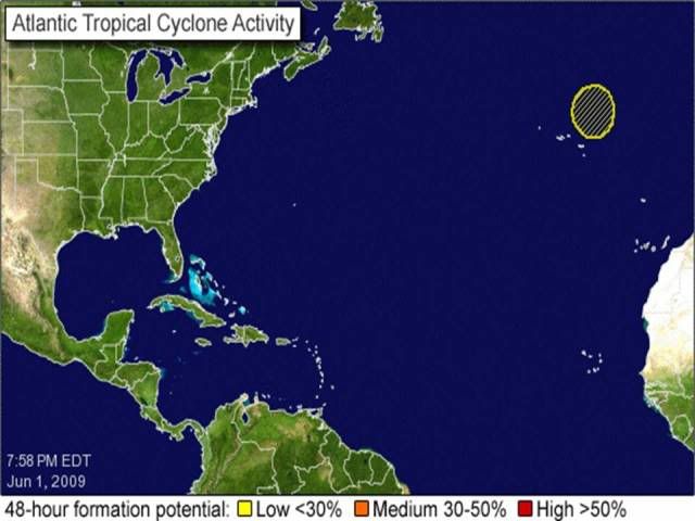
NE of Azores Islands : INVEST 92L
Moderator: S2k Moderators
-
Category 5

- Category 5

- Posts: 10074
- Age: 34
- Joined: Sun Feb 11, 2007 10:00 pm
- Location: New Brunswick, NJ
- Contact:


-
cycloneye

- Admin

- Posts: 139049
- Age: 67
- Joined: Thu Oct 10, 2002 10:54 am
- Location: San Juan, Puerto Rico
Re: NE of Azores Islands : INVEST 92L
Category 5 wrote:This should've been tagged this afternoon at least.
If you notice,they haved been tracking this since last night at 00 UTC.Agree on invest earlier in the day.
0 likes
-
Category 5
- Category 5
- Posts: 10074
- Age: 34
- Joined: Sun Feb 11, 2007 10:00 pm
- Location: New Brunswick, NJ
- Contact:
Re: NE of Azores Islands : INVEST 92L
cycloneye wrote:Category 5 wrote:This should've been tagged this afternoon at least.
If you notice,they haved been tracking this since last night at 00 UTC.Agree on invest earlier in the day.
I know, but its obvious this has past its peak now.
0 likes
-
Derek Ortt
-
cycloneye
- Admin
- Posts: 139049
- Age: 67
- Joined: Thu Oct 10, 2002 10:54 am
- Location: San Juan, Puerto Rico
Re: NE of Azores Islands : INVEST 92L
Its obvious that the Navy site is having problems because 90E and 93W have been deactivated but still appear there and 92L still doesnt appear.
http://www.nrlmry.navy.mil/TC.html
http://www.nrlmry.navy.mil/TC.html
0 likes

-
Category 5
- Category 5
- Posts: 10074
- Age: 34
- Joined: Sun Feb 11, 2007 10:00 pm
- Location: New Brunswick, NJ
- Contact:
Re: NE of Azores Islands : INVEST 92L
I dont see this becoming anything now. I do think though that this could very well be a post season designation though.
0 likes
-
Ed Mahmoud
Re: NE of Azores Islands : INVEST 92L
Over sub 20ºC ocean waters. And, as noted on the pre-invest thread, GFS takes what is now an impressive low and slowly fills it in over the next 3 days.

It does 'look' sort of tropical, except for the meager deep convection. Mostly -20 to -30ºC cloud tops. A couple of -40ish blobs. If it pops something up high enough to reach -60ºC, as a casual and amateur observer, I'd be more impressed.
That said, I think it may have been Hurricane Kyle of some years back, had a well developed eye at some point during its long travels, but was completely lacking in the colder cloud tops that produce the impressive colors on IR satellite loops.
0 likes
-
DanieleItalyRm

- Category 1

- Posts: 486
- Age: 38
- Joined: Mon Sep 22, 2008 7:52 am
- Location: Rome - Italy - Mediterranean sea
Tempesta con caratteristiche tropicali poco a nord delle Isole Azzorre, con evidente warm core a 850 hpa.
Con venti fino a 40 nodi ha un intensita' stimabile come tempesta tropicale (sebbene il Quickscat mostra i venti alle 13, dunque qualche ora prima la formazone dell'occhio della tempesta);
Molte le similitudini di formazione con l'Uragano Vince (2005) ma in questo periodo la superficie marina è ancor piu' fredda.
La formazione dell'occhio è stata comunque molto interessante, pari a TLC e cicloni tropicali. La pressione segnata da gfs è di 1005 hpa. In realta', come spesso capita,il ciclone è molto piccolo per essere identificato bene dal modello europeo. L'isola di Graciosa, ad esempio, ha segnato una pressione di 1000 hpa, stimo dunque una pressione reale di circa 996-998 Hpa nel centro.


Loop:
http://wind.met.fu-berlin.de/cgi-bin/meteosat.cgi?speed
http://www.sat24.com/Region.aspx?countr ... &type=loop
Last edited by DanieleItalyRm on Tue Jun 02, 2009 4:48 am, edited 1 time in total.
0 likes
-
littlevince

- S2K Supporter

- Posts: 768
- Joined: Fri Oct 21, 2005 10:45 am
- Location: Portugal
Re:
DanieleItalyRm wrote:con evidente warm core a 850 hpa
I also noticed that GFS always showed a "warm spot" in the center at 850hPa despite the relative low resolution of a global model (0.5º in this map)
GFS 850hPa Temperature

And last week I found the windfield in GFS runs some kind of interesting and a bit different than usual.
GFS Wind (based on an older run - Thursday 18z)

Not too much, but still has a small thunderstorm near the center

0 likes

-
DanieleItalyRm
- Category 1
- Posts: 486
- Age: 38
- Joined: Mon Sep 22, 2008 7:52 am
- Location: Rome - Italy - Mediterranean sea

-
senorpepr

- Military Met/Moderator

- Posts: 12542
- Age: 41
- Joined: Fri Aug 22, 2003 9:22 pm
- Location: Mackenbach, Germany
- Contact:
I'm not confident at all that this will become anything. However, the other day when we were forecasting for the Azores, watching this low did throw the word subtropical in my head.
Regardless, at that time, gusts associated with this system we hardly in the 20s. It'll be interesting to watch.
Regardless, at that time, gusts associated with this system we hardly in the 20s. It'll be interesting to watch.
0 likes
-
senorpepr
- Military Met/Moderator
- Posts: 12542
- Age: 41
- Joined: Fri Aug 22, 2003 9:22 pm
- Location: Mackenbach, Germany
- Contact:
Re: NE of Azores Islands : INVEST 92L
cycloneye wrote:BEGIN
NHC_ATCF
invest_al922009.invest
FSTDA
R
U
040
010
0000
200906020137
NONE
NOTIFY=ATRP
END
INVEST, AL, L, , , , , 92, 2009, DB, O, 2009060200, 9999999999, , , , , , METWATCH, , AL922009
AL, 92, 2009060100, , BEST, 0, 384N, 280W, 30, 1004, EX, 0, , 0, 0, 0, 0,
AL, 92, 2009060106, , BEST, 0, 387N, 263W, 30, 1003, EX, 0, , 0, 0, 0, 0,
AL, 92, 2009060112, , BEST, 0, 392N, 255W, 30, 1001, EX, 0, , 0, 0, 0, 0,
AL, 92, 2009060118, , BEST, 0, 401N, 247W, 35, 1001, EX, 34, NEQ, 50, 50, 0, 0,
AL, 92, 2009060200, , BEST, 0, 408N, 242W, 35, 1001, EX, 34, NEQ, 50, 50, 0, 0,
ftp://ftp.tpc.ncep.noaa.gov/atcf/tcweb/
Luis,
I see since you've posted this, NHC changed the status at 02/00Z from extratropical to low.
AL, 92, 2009060200, , BEST, 0, 408N, 242W, 35, 1001, LO, 34, NEQ, 50, 50, 0, 0, 1010, 240, 35, 0, 0, L, 0, , 0, 0, INVEST, D,
0 likes
-
DanieleItalyRm
- Category 1
- Posts: 486
- Age: 38
- Joined: Mon Sep 22, 2008 7:52 am
- Location: Rome - Italy - Mediterranean sea


Who is online
Users browsing this forum: No registered users and 42 guests