
-justin-
ATL : INVEST 94L
Moderator: S2k Moderators
-
Cookie

- S2K Supporter

- Posts: 477
- Age: 36
- Joined: Sun Dec 14, 2008 11:13 am
- Location: Isle Of lewis scotland
Re: ATL : INVEST 94L
Ed Mahmoud wrote:I think they're bored.
Just an opinion...
post of the month
0 likes
-
littlevince

- S2K Supporter
- Posts: 768
- Joined: Fri Oct 21, 2005 10:45 am
- Location: Portugal
Re: ATL : INVEST 94L
I really don't understand the "bored" stuff.
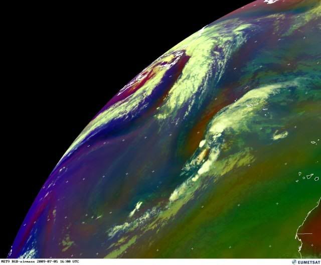
This was a nice looking system all night:

In the morning, visible (9z) looked far away for a "bored" stuff:

Water in the region are warmer than usual. In the 48 hours potential path there are islands where many people live.
What is the surprise or strange think with this Invest ? It's just an invest, a system under investigation.
Was it a wrong decision? I don't think so ! Shear has splitting it apart during the day, ok, but that happens many others times.
This was a nice looking system all night:
In the morning, visible (9z) looked far away for a "bored" stuff:
Water in the region are warmer than usual. In the 48 hours potential path there are islands where many people live.
What is the surprise or strange think with this Invest ? It's just an invest, a system under investigation.
Was it a wrong decision? I don't think so ! Shear has splitting it apart during the day, ok, but that happens many others times.
0 likes
-
wxman57

- Moderator-Pro Met

- Posts: 22482
- Age: 66
- Joined: Sat Jun 21, 2003 8:06 pm
- Location: Houston, TX (southwest)
Re: ATL : INVEST 94L
SSTs in the lower 70s and dropping fast now in its path. From the looks of it on satellite this morning, and from QS data, it would have been classified a TD if it had been any threat to land this morning. But it's now past its peak and weakening.
0 likes
-
cycloneye

- Admin

- Posts: 139165
- Age: 67
- Joined: Thu Oct 10, 2002 10:54 am
- Location: San Juan, Puerto Rico
Re: ATL : INVEST 94L
Avila literally says adios to it 
143
ABNT20 KNHC 042333
TWOAT
TROPICAL WEATHER OUTLOOK
NWS TPC/NATIONAL HURRICANE CENTER MIAMI FL
800 PM EDT SAT JUL 4 2009
FOR THE NORTH ATLANTIC...CARIBBEAN SEA AND THE GULF OF MEXICO...
THE SHOWER ACTIVITY ASSOCIATED WITH A NON-TROPICAL AREA OF LOW
PRESSURE LOCATED ABOUT 800 MILES SOUTHWEST OF THE AZORES HAS BECOME
DISORGANIZED. UPPER-LEVEL WINDS ARE NOT FAVORABLE FOR DEVELOPMENT.
THERE IS A LOW CHANCE...LESS THAN 30 PERCENT...OF THIS SYSTEM
BECOMING A TROPICAL OR SUBTROPICAL CYCLONE DURING THE NEXT 48
HOURS.
ELSEWHERE...TROPICAL CYCLONE FORMATION IS NOT EXPECTED DURING THE
NEXT 48 HOURS.
$$
FORECASTER AVILA
0 likes
-
cycloneye
- Admin
- Posts: 139165
- Age: 67
- Joined: Thu Oct 10, 2002 10:54 am
- Location: San Juan, Puerto Rico
Re: ATL : INVEST 94L

BEGIN
NHC_ATCF
invest_DEACTIVATE_al942009.ren
FSTDA
R
U
040
010
0000
200907042354
NONE
NOTIFY=ATRP
END
ftp://ftp.tpc.ncep.noaa.gov/atcf/tcweb/ ... 942009.ren
0 likes
-
thetruesms

- Professional-Met

- Posts: 844
- Age: 40
- Joined: Thu Aug 16, 2007 1:14 pm
- Location: Tallahasee, FL
- Contact:
Re:
HURAKAN wrote:
But srsly, I agree with wxman, littlevince, and whoever else was of similar opinion that I'm not mentioning - there were definitely some good reasons to keep a dedicated eye on this. Did it have a real great shot? No, but just imagine the backlash the other way if conditions became magically favorable and it caught everyone with their pants down. It's not like they created a situation where people felt obligated to throw up TS warnings on a moment's notice - it was just an invest.
Why did that last sentence remind me of Clerks? Hey, try not to issue any invests on your way through the parking lot!
0 likes
-
littlevince
- S2K Supporter
- Posts: 768
- Joined: Fri Oct 21, 2005 10:45 am
- Location: Portugal
Re: ATL : INVEST 94L
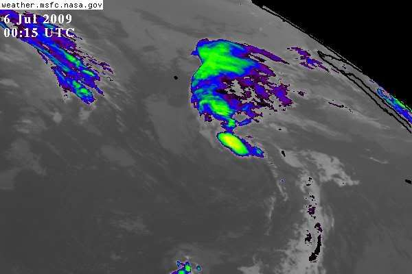
94L was discontinued, please correct if I'm wrong, but maybe is not dead yet, I think it established a new center:

ASCAT (23:53z)

Last visible (10:45z)

ASCAT (23:53z)
Last visible (10:45z)
0 likes
-
littlevince
- S2K Supporter
- Posts: 768
- Joined: Fri Oct 21, 2005 10:45 am
- Location: Portugal
Re: ATL : INVEST 94L


Last edited by littlevince on Sun Jul 05, 2009 4:39 pm, edited 2 times in total.
0 likes
-
littlevince
- S2K Supporter
- Posts: 768
- Joined: Fri Oct 21, 2005 10:45 am
- Location: Portugal
Re: ATL : INVEST 94L
cycloneye wrote::uarrow: That is the 94E best track data not for 94L.
Sorry. My mistake. I removed it.
0 likes


-
Aric Dunn
- Category 5

- Posts: 21228
- Age: 41
- Joined: Sun Sep 19, 2004 9:58 pm
- Location: Ready for the Chase.
- Contact:
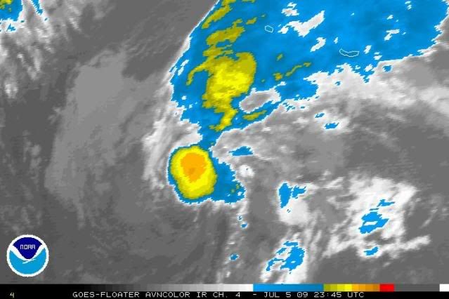
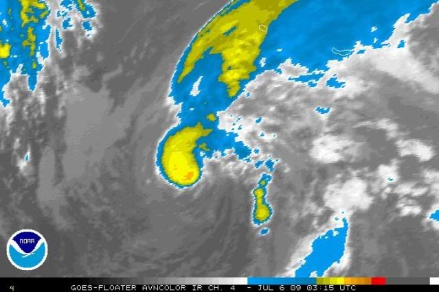
well considering that convection has wrapped completely around the center .. and on the latest IR the center is very evident with cooler cloud tops surrounding a slightly warm Center ( not an eye ).. i would say that this is at the moment our first named system .. lol but hey who am i to say.. lol
if convection re-fires with this present organization the NHC will have to upgrade it..
if convection re-fires with this present organization the NHC will have to upgrade it..
0 likes
Who is online
Users browsing this forum: No registered users and 55 guests