ATL: TROPICAL STORM BILL (03L)
Moderator: S2k Moderators
-
cyclonic chronic
bill has been a great call since he became a hurricane. there was a bit of confusion when he left the africian coast, but once the steering flow became deep enough, it was forecast by every model. a forecast 48-72 hrs ahead that is 50 NM off is great, even 24 hrs aint bad. plus just because your in the 34kt wind field doesnt mean youll feel it. IMO, it didnt become a cat. 5 because it started out as a big system.
0 likes

Re:
agree....from before inception, the models did what they were supposed to almost across the board....call for development of a large, strong system
cyclonic chronic wrote:bill has been a great call since he became a hurricane. there was a bit of confusion when he left the africian coast, but once the steering flow became deep enough, it was forecast by every model. a forecast 48-72 hrs ahead that is 50 NM off is great, even 24 hrs aint bad. plus just because your in the 34kt wind field doesnt mean youll feel it. IMO, it didnt become a cat. 5 because it started out as a big system.
0 likes
-
CrazyC83
- Professional-Met

- Posts: 33393
- Joined: Tue Mar 07, 2006 11:57 pm
- Location: Deep South, for the first time!
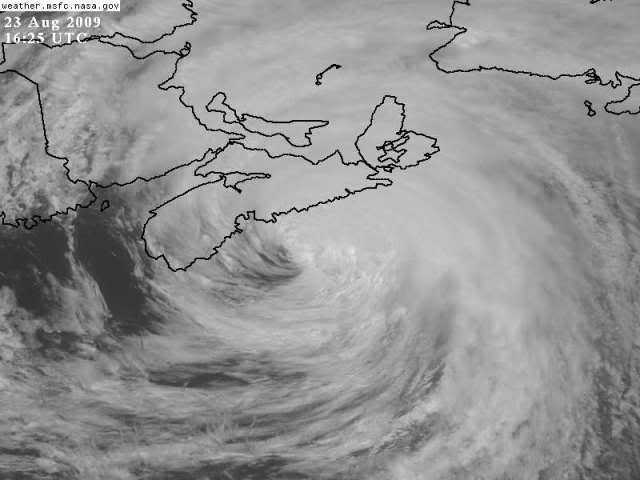
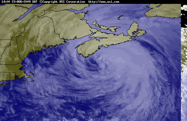
According to the CHC's latest bulletin, a buoy reported 965mb with a 52 kt wind (supports 960mb) this morning.
Any deviation to the left on the track would send strong hurricane-force winds into Halifax and coastal Nova Scotia. I'm not sure about the 75 kt; the winds penetrated to the surface quite well in Juan even at such a high latitude and 105 kt FL winds would be 94 kt at the surface (I don't think it is quite that strong, but stronger than 75 kt - my guess is about 85 kt).
Any deviation to the left on the track would send strong hurricane-force winds into Halifax and coastal Nova Scotia. I'm not sure about the 75 kt; the winds penetrated to the surface quite well in Juan even at such a high latitude and 105 kt FL winds would be 94 kt at the surface (I don't think it is quite that strong, but stronger than 75 kt - my guess is about 85 kt).
0 likes
-
Derek Ortt
-
Stratusxpeye

- Category 2

- Posts: 686
- Joined: Tue Jun 07, 2005 10:40 am
- Location: Tampa, Florida
- Contact:
Re:
Derek Ortt wrote:75KT is still probably too high. There is no evidence of surface winds that high
I completely agree. As I had stated a few days back (when everyone came at me saying this will be a CAT 2+ Heading landfall into downtown halifax) this would be a rapidly weakening, rapidly accelerating system posibly becoming xtra-tropical already when it reached the halifax NS area.
0 likes


Re: ATL: HURRICANE BILL (03L)
magnusson_r wrote:I've been in downtown Halifax the past 24 hours and I can say that there's nothing of significance to report here in the form of either wind or rain.
This has played out exactly the way Environment Canada and Peter Coade predicted on 18-19 August (see my earlier post): A much-diminished storm that has remained well offshore from Nova Scotia.
And I must say that I am somewhat disappointed by certain posters on here who reacted somewhat imperiously to my suggestion yesterday that this storm would be a non-event for Halifax.
Incidentally, Piers Corbyn was also right on the money when he predicted several days ago that Bill would track slightly to the right of projections. I'll be following Mr Corbyn's forecasts more closely from now on.
I would say this IS an event for Halifax. Even if Bill is weaker than 75kt its still very large and only about 50 miles off the coast. im sure there will be power outages and some trees knocked down. if this were to happen in your neighborhood, you would consider it an event.
0 likes
-
Derek Ortt
-
HURAKAN

- Professional-Met
- Posts: 46086
- Age: 37
- Joined: Thu May 20, 2004 4:34 pm
- Location: Key West, FL
- Contact:
655
WTNT33 KNHC 231802
TCPAT3
BULLETIN
HURRICANE BILL INTERMEDIATE ADVISORY NUMBER 33A
NWS TPC/NATIONAL HURRICANE CENTER MIAMI FL AL032009
200 PM AST SUN AUG 23 2009
...BILL MOVING NEAR NOVA SCOTIA...
AT 2 PM AST...1800 UTC...ENVIRONMENT CANADA HAS DISCONTINUED THE
TROPICAL STORM WARNING IN NOVA SCOTIA FROM CHARLESVILLE IN
SHELBURNE COUNTY TO HUBBARDS IN HALIFAX COUNTY...AND DISCONTINUED
THE TROPICAL STORM WATCH FROM WEST OF MALAGASH IN CUMBERLAND COUNTY
TO TIDNISH IN CUMBERLAND COUNTY...AND DISCONTINUED THE TROPICAL
STORM WATCH FROM FORT LAWRENCE IN CUMBERLAND COUNTY TO
CHARLESVILLE.
A TROPICAL STORM WARNING IS NOW IN EFFECT IN EASTERN NOVA SCOTIA
FROM EAST OF HUBBARDS TO LISMORE...AND A HURRICANE WATCH IS IN
EFFECT FROM ECUM SECUM IN HALIFAX COUNTY TO POINT ACONIIN IN CAPE
BRETON COUNTY.
A TROPICAL STORM WARNING REMAINS IN EFFECT ALONG THE SOUTHEASTERN
COAST OF NEWFOUNDLAND FROM STONE'S COVE TO BONAVISTA. A TROPICAL
STORM WATCH REMAINS IN EFFECT FOR THE WEST AND SOUTH COAST OF
NEWFOUNDLAND FROM PARSONS POND AROUND TO STONE'S COVE...AND ALONG
THE EAST COAST OF NEWFOUNDLAND FROM BONAVISTA TO HARBOUR DEEP.
FOR STORM INFORMATION SPECIFIC TO YOUR AREA OUTSIDE OF THE UNITED
STATES...PLEASE MONITOR PRODUCTS ISSUED BY YOUR NATIONAL
METEOROLOGICAL SERVICE. FOR STORM INFORMATION SPECIFIC TO YOUR
AREA IN THE UNITED STATES...INCLUDING POSSIBLE INLAND WATCHES AND
WARNINGS...PLEASE MONITOR PRODUCTS ISSUED BY YOUR LOCAL NATIONAL
WEATHER SERVICE FORECAST OFFICE.
AT 200 PM AST...1800 UTC...THE CENTER OF HURRICANE BILL WAS LOCATED
NEAR LATITUDE 44.4 NORTH...LONGITUDE 62.5 WEST OR ABOUT 60 MILES...
95 KM...EAST-SOUTHEAST OF HALIFAX NOVA SCOTIA.
BILL IS MOVING TOWARD THE NORTHEAST NEAR 35 MPH...56 KM/HR...AND A
FURTHER INCREASE IN FORWARD SPEED IS EXPECTED TODAY AND TONIGHT.
ON THE FORECAST TRACK...THE CENTER OF BILL WILL PASS NEAR OR JUST
OFF THE EASTERN COAST OF NOVA SCOTIA TODAY...AND NEAR OR OVER
SOUTHEASTERN NEWFOUNDLAND TONIGHT OR EARLY MONDAY.
MAXIMUM SUSTAINED WINDS ARE NEAR 80 MPH...130 KM/HR...WITH HIGHER
GUSTS. BILL IS A CATEGORY ONE HURRICANE ON THE SAFFIR-SIMPSON
SCALE. SOME WEAKENING IS FORECAST AND BILL IS LIKELY TO LOSE
TROPICAL CHARACTERISTICS DURING THE NEXT 24 HOURS.
HURRICANE FORCE WINDS EXTEND OUTWARD UP TO 85 MILES...140 KM...FROM
THE CENTER...AND TROPICAL STORM FORCE WINDS EXTEND OUTWARD UP TO 290
MILES...465 KM.
ESTIMATED MINIMUM CENTRAL PRESSURE IS 970 MB...28.64 INCHES.
TOTAL RAIN ACCUMULATIONS OF 3 TO 5 INCHES WITH ISOLATED MAXIMUM
AMOUNTS OF 7 INCHES ARE EXPECTED NEAR THE TRACK OF BILL ACROSS NOVA
SCOTIA...PRINCE EDWARD ISLAND AND NEWFOUNDLAND.
LARGE AND DANGEROUS SWELLS GENERATED BY HURRICANE BILL WILL BE
IMPACTING THE ATLANTIC MARITIMES OF CANADA TODAY. SWELLS ALONG THE
U.S. EAST COAST SHOULD GRADUALLY DIMINISH TODAY AND TONIGHT.
...SUMMARY OF 200 PM AST INFORMATION...
LOCATION...44.4N 62.5W
MAXIMUM SUSTAINED WINDS...80 MPH
PRESENT MOVEMENT...NORTHEAST OR 45 DEGREES AT 35 MPH
MINIMUM CENTRAL PRESSURE...970 MB
THE NEXT ADVISORY WILL BE ISSUED BY THE NATIONAL
HURRICANE CENTER AT 500 PM AST.
$$
FORECASTER PASCH
0 likes

Re: ATL: HURRICANE BILL (03L)
RNGR wrote:magnusson_r wrote:I've been in downtown Halifax the past 24 hours and I can say that there's nothing of significance to report here in the form of either wind or rain.
This has played out exactly the way Environment Canada and Peter Coade predicted on 18-19 August (see my earlier post): A much-diminished storm that has remained well offshore from Nova Scotia.
And I must say that I am somewhat disappointed by certain posters on here who reacted somewhat imperiously to my suggestion yesterday that this storm would be a non-event for Halifax.
Incidentally, Piers Corbyn was also right on the money when he predicted several days ago that Bill would track slightly to the right of projections. I'll be following Mr Corbyn's forecasts more closely from now on.
I'm no pro but Bill still looks large and dangerous to me....
I would say this IS an event for Halifax. Even if Bill is weaker than 75kt its still very large and only about 50 miles off the coast. im sure there will be power outages and some trees knocked down. if this were to happen in your neighborhood, you would consider it an event.
0 likes
Re: ATL: HURRICANE BILL (03L)
If the center doesn't move ashore in nova scotia, i can't see him not landfalling in new foundland later today....

0 likes
Re: ATL: HURRICANE BILL (03L)
kat61 wrote:sorry RNGR..thought I posted below you....not on..
its all good
0 likes


-
HURAKAN
- Professional-Met
- Posts: 46086
- Age: 37
- Joined: Thu May 20, 2004 4:34 pm
- Location: Key West, FL
- Contact:
993
WTNT33 KNHC 232036
TCPAT3
BULLETIN
HURRICANE BILL ADVISORY NUMBER 34
NWS TPC/NATIONAL HURRICANE CENTER MIAMI FL AL032009
500 PM AST SUN AUG 23 2009
...BILL NEAR EASTERN NOVA SCOTIA...HEADED FOR NEWFOUNDLAND...
A TROPICAL STORM WARNING REMAINS IN EFFECT IN EASTERN NOVA SCOTIA
FROM EAST OF HUBBARDS TO LISMORE...AND A HURRICANE WATCH IS IN
EFFECT FROM ECUM SECUM IN HALIFAX COUNTY TO POINT ACONI IN CAPE
BRETON COUNTY.
A TROPICAL STORM WATCH REMAINS IN EFFECT FOR PRINCE EDWARD ISLAND
FROM VICTORIA IN QUEEN COUNTY NORTHWARD TO LOWER DARNLEY IN PRINCE
COUNTY.
A TROPICAL STORM WARNING REMAINS IN EFFECT ALONG THE SOUTHEASTERN
COAST OF NEWFOUNDLAND FROM STONES COVE TO BONAVISTA. A TROPICAL
STORM WATCH REMAINS IN EFFECT FOR THE WEST AND SOUTH COAST OF
NEWFOUNDLAND FROM PARSONS POND AROUND TO STONES COVE...AND ALONG
THE EAST COAST OF NEWFOUNDLAND FROM BONAVISTA TO HARBOUR DEEP.
FOR STORM INFORMATION SPECIFIC TO YOUR AREA OUTSIDE OF THE UNITED
STATES...PLEASE MONITOR PRODUCTS ISSUED BY YOUR NATIONAL
METEOROLOGICAL SERVICE.
AT 500 PM AST...2100 UTC...THE CENTER OF HURRICANE BILL WAS LOCATED
NEAR LATITUDE 45.1 NORTH...LONGITUDE 60.8 WEST OR ABOUT 385 MILES...
620 KM...WEST-SOUTHWEST OF CAPE RACE NEWFOUNDLAND.
BILL IS MOVING TOWARD THE NORTHEAST NEAR 35 MPH...56 KM/HR...AND A
FURTHER INCREASE IN FORWARD SPEED IS EXPECTED TONIGHT AND MONDAY.
ON THE FORECAST TRACK THE CENTER OF BILL PASS NEAR OR OVER
SOUTHEASTERN NEWFOUNDLAND TONIGHT OR EARLY MONDAY.
MAXIMUM SUSTAINED WINDS HAVE DECREASED TO NEAR 75 MPH...120
KM/HR...WITH HIGHER GUSTS. BILL IS A CATEGORY ONE HURRICANE ON THE
SAFFIR-SIMPSON SCALE. WEAKENING IS FORECAST DURING THE NEXT 24
HOURS AND BILL IS EXPECTED TO BECOME EXTRATROPICAL ON MONDAY.
HURRICANE FORCE WINDS EXTEND OUTWARD UP TO 60 MILES...95 KM...FROM
THE CENTER...AND TROPICAL STORM FORCE WINDS EXTEND OUTWARD UP TO 290
MILES...465 KM.
ESTIMATED MINIMUM CENTRAL PRESSURE IS 970 MB...28.64 INCHES.
TOTAL RAIN ACCUMULATIONS OF 2 TO 4 INCHES WITH ISOLATED MAXIMUM
AMOUNTS OF 6 INCHES ARE EXPECTED NEAR THE TRACK OF BILL ACROSS
NEWFOUNDLAND. AN ADDITIONAL 1 TO 2 INCHES OF RAIN ARE POSSIBLE
OVER THE EASTERN END OF NOVA SCOTIA AND PRINCE EDWARD ISLAND.
LARGE AND DANGEROUS SWELLS GENERATED BY HURRICANE BILL WILL BE
IMPACTING THE ATLANTIC MARITIMES OF CANADA TONIGHT.
...SUMMARY OF 500 PM AST INFORMATION...
LOCATION...45.1N 60.8W
MAXIMUM SUSTAINED WINDS...75 MPH
PRESENT MOVEMENT...NORTHEAST OR 50 DEGREES AT 35 MPH
MINIMUM CENTRAL PRESSURE...970 MB
AN INTERMEDIATE ADVISORY WILL BE ISSUED BY THE NATIONAL HURRICANE
CENTER AT 800 PM AST FOLLOWED BY THE NEXT COMPLETE ADVISORY AT 1100
PM AST.
$$
FORECASTER KIMBERLAIN/PASCH
416
WTNT43 KNHC 232036
TCDAT3
HURRICANE BILL DISCUSSION NUMBER 34
NWS TPC/NATIONAL HURRICANE CENTER MIAMI FL AL032009
500 PM AST SUN AUG 23 2009
BILL IS GRADUALLY WEAKENING WHILE LOSING SOME OF ITS TROPICAL
APPEARANCE. THE SATELLITE PRESENTATION HAS BEEN GRADUALLY
DETERIORATING...WITH THE CLOUD PATTERN BECOMING MORE ASYMMETRIC AND
THE DEEPEST CONVECTION CONFINED TO THE NORTHEAST SEMICIRCLE.
DVORAK T-NUMBERS OF 3.5 AND 4.0 FROM TAFB AND SAB...RESPECTIVELY
...AND THE ASSUMPTION OF A CONTINUED SLOW WEAKENING AS BILL
TRAVERSES COOLER WATERS...YIELD AN INITIAL INTENSITY ESTIMATE OF 65
KT FOR THIS ADVISORY. THE FORECAST CALLS FOR STEADY WEAKENING...
AND EXTRATROPICAL TRANSITION IS EXPECTED TO BE COMPLETE WITHIN 24
HOURS...IN AGREEMENT WITH THE GLOBAL MODEL GUIDANCE. BY 96 HOURS
BILL IS PREDICTED TO HAVE MERGED WITH A LARGER CYCLONIC CIRCULATION
NEAR THE BRITISH ISLES.
BILL HAS CONTINUED TO ACCELERATE...AND THE INITIAL MOTION ESTIMATE
IS NOW 050/030. SOME FURTHER ACCELERATION IS LIKELY DURING THE NEXT
24-36 HOURS AS THE CYCLONE BECOMES FULLY EMBEDDED WITHIN STRONG
WEST-SOUTHWESTERLY FLOW AHEAD OF A SHORTWAVE TROUGH LIFTING OUT OF
THE EASTERN UNITED STATES. BEYOND 36 HOURS...SOME SLOWING OF THE
FORWARD SPEED IS EXPECTED AS THE EXTRATROPICAL REMNANT OF BILL
INTERACTS WITH THE LARGE CYCLONIC CIRCULATION OVER THE NORTHEAST
ATLANTIC. THE OFFICIAL FORECAST REPRESENTS AN UPDATE OF THE
PREVIOUS ADVISORY...WITH NO SIGNIFICANT CHANGES.
LARGE AND DANGEROUS SWELLS ASSOCIATED WITH BILL WILL CONTINUE
IMPACTING THE CANADIAN MARITIMES DURING THE NEXT 12 TO 24 HOURS...
WHILE SWELLS ALONG THE EAST COAST OF THE UNITED STATES WILL CONTINUE
TO SUBSIDE TONIGHT.
FORECAST POSITIONS AND MAX WINDS
INITIAL 23/2100Z 45.1N 60.8W 65 KT
12HR VT 24/0600Z 47.7N 54.5W 60 KT
24HR VT 24/1800Z 50.0N 43.8W 50 KT...EXTRATROPICAL
36HR VT 25/0600Z 51.5N 32.0W 40 KT...EXTRATROPICAL
48HR VT 25/1800Z 52.5N 21.0W 35 KT...EXTRATROPICAL
72HR VT 26/1800Z 57.0N 5.0W 30 KT...EXTRATROPICAL
96HR VT 27/1800Z...DISSIPATED
$$
FORECASTER KIMBERLAIN/PASCH
0 likes
Re: ATL: HURRICANE BILL (03L)
Bill is going to run into Newfoundland....if he hasn't skirted land on Nova Scotia already...


0 likes

Re: ATL: HURRICANE BILL (03L)
Apparently 3 people who were wave watching at the beach in Maine were swept out to sea. Coast gaurd is looking for them. Guess they didnt head the high surf advisory. I see these people splashing around in hurricane churned surf every year when a storm is nearby and every year I think, if they only knew what could happen. This was going on quite a bit in the Ike surf last year. People should have better sense. I hope they are found though.
0 likes
Re: ATL: HURRICANE BILL (03L)
With water temps in the 50s...all we can do is hope for a miracle. Story and photo from WMTW News 8 out of Maine.
MOUNT DESERT ISLAND, Maine Bar Harbor police said several people have been swept into the ocean at Acadia National Park. The victims had gone to Thunder Hole on Sunday to watching the rough surf created by Hurricane Bill when they were hit by a large wave. As many as six people were rescued, but the Coast Guard said three more are still believed to be in the water.
Stay with News 8 and WMTW.com for updates on this developing story.

Crowds of spectators were standing on rocks such as this...enjoying the waves Bill was generating. This is a sad story and needless turn of events...


(photo from WCVB Boston, taken today at Acadia)
MOUNT DESERT ISLAND, Maine Bar Harbor police said several people have been swept into the ocean at Acadia National Park. The victims had gone to Thunder Hole on Sunday to watching the rough surf created by Hurricane Bill when they were hit by a large wave. As many as six people were rescued, but the Coast Guard said three more are still believed to be in the water.
Stay with News 8 and WMTW.com for updates on this developing story.
Crowds of spectators were standing on rocks such as this...enjoying the waves Bill was generating. This is a sad story and needless turn of events...
(photo from WCVB Boston, taken today at Acadia)
PTPatrick wrote:Apparently 3 people who were wave watching at the beach in Maine were swept out to sea. Coast gaurd is looking for them. Guess they didnt head the high surf advisory. I see these people splashing around in hurricane churned surf every year when a storm is nearby and every year I think, if they only knew what could happen. This was going on quite a bit in the Ike surf last year. People should have better sense. I hope they are found though.
Last edited by jinftl on Sun Aug 23, 2009 5:11 pm, edited 2 times in total.
0 likes
-
vbhoutex

- Storm2k Executive

- Posts: 28974
- Age: 72
- Joined: Wed Oct 09, 2002 11:31 pm
- Location: Spring Branch area, Houston, TX
- Contact:
Re: ATL: HURRICANE BILL (03L)
This is a link to another article about this in our forums. http://www.storm2k.org/phpbb2/viewtopic.php?f=59&t=106305&p=1910794#p1910794
0 likes
Who is online
Users browsing this forum: No registered users and 104 guests