

BEGIN
NHC_ATCF
invest_al992009.invest
FSTDA
R
U
040
010
0000
200909251009
NONE
NOTIFY=ATRP
END
INVEST, AL, L, , , , , 99, 2009, DB, O, 2009092506, 9999999999, , , , , , METWATCH, , AL992009
AL, 99, 2009092406, , BEST, 0, 131N, 244W, 20, 1011, DB, 0, , 0, 0, 0, 0,
AL, 99, 2009092412, , BEST, 0, 133N, 254W, 20, 1010, DB, 0, , 0, 0, 0, 0,
AL, 99, 2009092418, , BEST, 0, 136N, 265W, 20, 1010, DB, 0, , 0, 0, 0, 0,
AL, 99, 2009092500, , BEST, 0, 139N, 277W, 20, 1010, DB, 0, , 0, 0, 0, 0,
AL, 99, 2009092506, , BEST, 0, 142N, 290W, 20, 1010, DB, 34
ATL : TROPICAL DEPRESSION EIGHT (08L)
Moderator: S2k Moderators
-
HURAKAN

- Professional-Met

- Posts: 46086
- Age: 37
- Joined: Thu May 20, 2004 4:34 pm
- Location: Key West, FL
- Contact:
ATL: TROPICAL DEPRESSION EIGHT - Models
972
WHXX01 KWBC 251018
CHGHUR
TROPICAL CYCLONE GUIDANCE MESSAGE
NWS TPC/NATIONAL HURRICANE CENTER MIAMI FL
1018 UTC FRI SEP 25 2009
DISCLAIMER...NUMERICAL MODELS ARE SUBJECT TO LARGE ERRORS.
PLEASE REFER TO NHC OFFICIAL FORECASTS FOR TROPICAL CYCLONE
AND SUBTROPICAL CYCLONE INFORMATION.
ATLANTIC OBJECTIVE AIDS FOR
DISTURBANCE INVEST (AL992009) 20090925 0600 UTC
...00 HRS... ...12 HRS... ...24 HRS. .. ...36 HRS...
090925 0600 090925 1800 090926 0600 090926 1800
LAT LON LAT LON LAT LON LAT LON
BAMS 14.2N 29.0W 15.9N 31.8W 17.5N 34.4W 19.3N 36.6W
BAMD 14.2N 29.0W 15.5N 31.5W 16.8N 33.7W 18.3N 35.6W
BAMM 14.2N 29.0W 15.5N 31.7W 16.7N 33.9W 18.0N 36.0W
LBAR 14.2N 29.0W 15.4N 31.3W 17.0N 33.4W 18.6N 35.1W
SHIP 20KTS 21KTS 22KTS 22KTS
DSHP 20KTS 21KTS 22KTS 22KTS
...48 HRS... ...72 HRS... ...96 HRS. .. ..120 HRS...
090927 0600 090928 0600 090929 0600 090930 0600
LAT LON LAT LON LAT LON LAT LON
BAMS 20.9N 38.0W 22.7N 40.1W 24.5N 42.7W 27.0N 44.5W
BAMD 19.7N 36.9W 21.6N 38.7W 23.0N 40.5W 24.3N 42.1W
BAMM 19.1N 37.4W 20.2N 39.8W 21.1N 42.9W 22.7N 46.1W
LBAR 20.3N 35.9W 22.3N 34.9W 23.2N 31.8W 22.7N 26.8W
SHIP 26KTS 27KTS 28KTS 34KTS
DSHP 26KTS 27KTS 28KTS 34KTS
...INITIAL CONDITIONS...
LATCUR = 14.2N LONCUR = 29.0W DIRCUR = 285DEG SPDCUR = 12KT
LATM12 = 13.6N LONM12 = 26.5W DIRM12 = 285DEG SPDM12 = 12KT
LATM24 = 13.1N LONM24 = 24.4W
WNDCUR = 20KT RMAXWD = 0NM WNDM12 = 20KT
CENPRS = 1010MB OUTPRS = 1012MB OUTRAD = 150NM SDEPTH = M
RD34NE = 0NM RD34SE = 0NM RD34SW = 0NM RD34NW = 0NM
$$
NNNN
0 likes


-
HURAKAN
- Professional-Met
- Posts: 46086
- Age: 37
- Joined: Thu May 20, 2004 4:34 pm
- Location: Key West, FL
- Contact:
247
ABNT20 KNHC 251131
TWOAT
TROPICAL WEATHER OUTLOOK
NWS TPC/NATIONAL HURRICANE CENTER MIAMI FL
800 AM EDT FRI SEP 25 2009
FOR THE NORTH ATLANTIC...CARIBBEAN SEA AND THE GULF OF MEXICO...
SHOWER ACTIVITY ASSOCIATED WITH A TROPICAL WAVE LOCATED ABOUT
325 MILES WEST OF THE CAPE VERDE ISLANDS HAS BECOME BETTER ORGANIZED
THIS MORNING. SOME ADDITIONAL DEVELOPMENT OF THIS SYSTEM IS
POSSIBLE DURING THE NEXT 24 HOURS BEFORE UPPER-LEVEL WINDS BECOME
LESS CONDUCIVE. THERE IS A MEDIUM CHANCE...30 TO 50 PERCENT...OF
THIS SYSTEM BECOMING A TROPICAL CYCLONE DURING THE NEXT 48 HOURS.
ELSEWHERE...TROPICAL CYCLONE FORMATION IS NOT EXPECTED DURING THE
NEXT 48 HOURS.
$$
FORECASTER BEVEN
0 likes


-
wxman57

- Moderator-Pro Met

- Posts: 22480
- Age: 66
- Joined: Sat Jun 21, 2003 8:06 pm
- Location: Houston, TX (southwest)
Re: ATL : INVEST 99L
Looks like another early recurve. There's a sharp trof axis between 40-45W in its path. Should run into significant shear in 4-5 days, which should give it the "Fred treatment". Look for the remnant LLC to be near the southeast U.S. coast in 2 weeks. 
Last edited by wxman57 on Fri Sep 25, 2009 9:23 am, edited 1 time in total.
0 likes

-
HURAKAN
- Professional-Met
- Posts: 46086
- Age: 37
- Joined: Thu May 20, 2004 4:34 pm
- Location: Key West, FL
- Contact:
Re: ATL : INVEST 99L
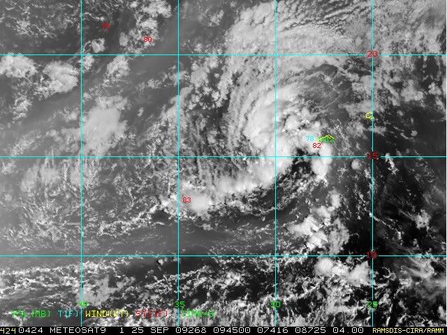
A tropical wave (99L) is located near 15N, 30W, about 300 miles west of the Cape Verdes Islands. This wave has seen an increase in heavy thunderstorm activity this morning, and low-level spiral bands have formed. The system can already be classified as a tropical depression using the satellite-based Dvorak technique. This morning's QuickSCAT pass showed a loose but closed circulation, with top winds of 30 mph in the heaviest thunderstorms. Wind shear is moderate, about 10 - 20 knots. There is a modest amount of dry air to 99L's west that does not appear to be interfering with the storm's organization.
As 99L moves west-northwest over the next two days, sea surface temperatures will cool by 1°C and winds shear will remain in the moderate range. Some dry air may also affect the storm. These conditions give 99L a good chance of forming into a tropical depression, and NHC has given the system a moderate (30 - 50%) chance of developing into a tropical depression by Wednesday. By Thursday, wind shear will increase to the high range, 20 - 30 knots, and 99L will probably weaken or be torn apart. None of the computer models forecast development of 99L or any other system in the Atlantic over the next seven days.
Jeff Masters: http://www.wunderground.com/blog/JeffMa ... rynum=1330
0 likes
-
Stephanie

- S2K Supporter

- Posts: 23842
- Age: 61
- Joined: Thu Feb 06, 2003 9:53 am
- Location: Glassboro, NJ
Re: ATL : INVEST 99L
wxman57 wrote:Looks like another early recurve. There's a sharp trof axis between 40-45W in its path. Should run into significant shear in 4-5 days, which should give it the "Fred treatment". Look for the remnant LLC to be near the southeast U.S. coast in 2 weeks
0 likes

Re: ATL : INVEST 99L
It looks pretty good, I think it could become Grace but it will be a short lived storm as conditions will be less favorable in a couple of days.
0 likes
-
somethingfunny

- ChatStaff

- Posts: 3926
- Age: 35
- Joined: Thu May 31, 2007 10:30 pm
- Location: McKinney, Texas

-
MGC

- S2K Supporter
- Posts: 5792
- Joined: Sun Mar 23, 2003 9:05 pm
- Location: Pass Christian MS, or what is left.
Re: ATL : INVEST 99L
Sure does look like a TC...we'll see what the NHC does later today....MGC
0 likes
-
wxman57
- Moderator-Pro Met
- Posts: 22480
- Age: 66
- Joined: Sat Jun 21, 2003 8:06 pm
- Location: Houston, TX (southwest)
Re: ATL : INVEST 99L
Already heading off to the northwest. Might never look as good as it does now.
0 likes
Who is online
Users browsing this forum: No registered users and 73 guests