
Take care
WPAC : TROPICAL STORM MELOR (20W)
Moderator: S2k Moderators

-
HURAKAN

- Professional-Met

- Posts: 46086
- Age: 37
- Joined: Thu May 20, 2004 4:34 pm
- Location: Key West, FL
- Contact:

WTPN34 PGTW 060900
MSGID/GENADMIN/NAVMARFCSTCEN PEARL HARBOR HI/JTWC//
SUBJ/TROPICAL CYCLONE WARNING//
RMKS/
1. TYPHOON 20W (MELOR) WARNING NR 029
02 ACTIVE TROPICAL CYCLONES IN NORTHWESTPAC
MAX SUSTAINED WINDS BASED ON ONE-MINUTE AVERAGE
WIND RADII VALID OVER OPEN WATER ONLY
---
WARNING POSITION:
060600Z --- NEAR 23.8N 131.0E
MOVEMENT PAST SIX HOURS - 335 DEGREES AT 14 KTS
POSITION ACCURATE TO WITHIN 040 NM
POSITION BASED ON EYE FIXED BY SATELLITE
PRESENT WIND DISTRIBUTION:
MAX SUSTAINED WINDS - 115 KT, GUSTS 140 KT
WIND RADII VALID OVER OPEN WATER ONLY
RADIUS OF 064 KT WINDS - 085 NM NORTHEAST QUADRANT
080 NM SOUTHEAST QUADRANT
065 NM SOUTHWEST QUADRANT
075 NM NORTHWEST QUADRANT
RADIUS OF 050 KT WINDS - 125 NM NORTHEAST QUADRANT
125 NM SOUTHEAST QUADRANT
090 NM SOUTHWEST QUADRANT
090 NM NORTHWEST QUADRANT
RADIUS OF 034 KT WINDS - 175 NM NORTHEAST QUADRANT
145 NM SOUTHEAST QUADRANT
140 NM SOUTHWEST QUADRANT
155 NM NORTHWEST QUADRANT
REPEAT POSIT: 23.8N 131.0E
---
FORECASTS:
12 HRS, VALID AT:
061800Z --- 26.6N 131.0E
MAX SUSTAINED WINDS - 105 KT, GUSTS 130 KT
WIND RADII VALID OVER OPEN WATER ONLY
RADIUS OF 064 KT WINDS - 065 NM NORTHEAST QUADRANT
065 NM SOUTHEAST QUADRANT
055 NM SOUTHWEST QUADRANT
060 NM NORTHWEST QUADRANT
RADIUS OF 050 KT WINDS - 105 NM NORTHEAST QUADRANT
110 NM SOUTHEAST QUADRANT
085 NM SOUTHWEST QUADRANT
085 NM NORTHWEST QUADRANT
RADIUS OF 034 KT WINDS - 170 NM NORTHEAST QUADRANT
150 NM SOUTHEAST QUADRANT
145 NM SOUTHWEST QUADRANT
155 NM NORTHWEST QUADRANT
VECTOR TO 24 HR POSIT: 025 DEG/ 17 KTS
---
24 HRS, VALID AT:
070600Z --- 29.7N 132.6E
MAX SUSTAINED WINDS - 095 KT, GUSTS 115 KT
WIND RADII VALID OVER OPEN WATER ONLY
RADIUS OF 064 KT WINDS - 055 NM NORTHEAST QUADRANT
055 NM SOUTHEAST QUADRANT
045 NM SOUTHWEST QUADRANT
050 NM NORTHWEST QUADRANT
RADIUS OF 050 KT WINDS - 095 NM NORTHEAST QUADRANT
095 NM SOUTHEAST QUADRANT
075 NM SOUTHWEST QUADRANT
075 NM NORTHWEST QUADRANT
RADIUS OF 034 KT WINDS - 170 NM NORTHEAST QUADRANT
160 NM SOUTHEAST QUADRANT
150 NM SOUTHWEST QUADRANT
155 NM NORTHWEST QUADRANT
VECTOR TO 36 HR POSIT: 035 DEG/ 21 KTS
---
36 HRS, VALID AT:
071800Z --- 33.1N 135.5E
MAX SUSTAINED WINDS - 085 KT, GUSTS 105 KT
WIND RADII VALID OVER OPEN WATER ONLY
RADIUS OF 064 KT WINDS - 045 NM NORTHEAST QUADRANT
045 NM SOUTHEAST QUADRANT
040 NM SOUTHWEST QUADRANT
040 NM NORTHWEST QUADRANT
RADIUS OF 050 KT WINDS - 080 NM NORTHEAST QUADRANT
080 NM SOUTHEAST QUADRANT
070 NM SOUTHWEST QUADRANT
070 NM NORTHWEST QUADRANT
RADIUS OF 034 KT WINDS - 170 NM NORTHEAST QUADRANT
165 NM SOUTHEAST QUADRANT
155 NM SOUTHWEST QUADRANT
160 NM NORTHWEST QUADRANT
VECTOR TO 48 HR POSIT: 040 DEG/ 26 KTS
---
EXTENDED OUTLOOK:
48 HRS, VALID AT:
080600Z --- 37.0N 139.8E
MAX SUSTAINED WINDS - 055 KT, GUSTS 070 KT
WIND RADII VALID OVER OPEN WATER ONLY
BECOMING EXTRATROPICAL
RADIUS OF 050 KT WINDS - 035 NM NORTHEAST QUADRANT
035 NM SOUTHEAST QUADRANT
030 NM SOUTHWEST QUADRANT
030 NM NORTHWEST QUADRANT
RADIUS OF 034 KT WINDS - 140 NM NORTHEAST QUADRANT
145 NM SOUTHEAST QUADRANT
115 NM SOUTHWEST QUADRANT
115 NM NORTHWEST QUADRANT
VECTOR TO 72 HR POSIT: 045 DEG/ 28 KTS
---
72 HRS, VALID AT:
090600Z --- 44.6N 150.9E
MAX SUSTAINED WINDS - 035 KT, GUSTS 045 KT
WIND RADII VALID OVER OPEN WATER ONLY
EXTRATROPICAL
---
REMARKS:
060900Z POSITION NEAR 24.5N 131.0E.
TYPHOON (TY) 20W (MELOR), LOCATED APPROXIMATELY 235 NM SOUTHEAST OF
OKINAWA, JAPAN, HAS TRACKED NORTH-NORTHWESTWARD AT 14 KNOTS OVER THE
PAST SIX HOURS. RECENT ANIMATED MULTISPECTRAL IMAGERY CONTINUES TO
SHOW A FULLY-DEVELOPED TYPHOON WITH A WELL-DEFINED EYE AND ANIMATED
WATER VAPOR IMAGERY INDICATES THAT TY MELOR HAS DEVELOPED BETTER
POLEWARD OUTFLOW INTO THE MID-LATITUDE WESTERLIES AS IT IS STARTING
TO CREST THE SUBTROPICAL RIDGE AXIS. HOWEVER, RECENT INFRARED
IMAGERY REVEALS WANING DEEP CONVECTION AND DVORAK ESTIMATES FROM
PGTW, KNES, AND RJTD HAVE DROPPED IN THE LAST 12 HOURS. THE CURRENT
INTENSITY IS BASED ON THESE DVORAK ESTIMATES. THE CURRENT POSITION
IS ALSO BASED ON FIXES BY THE SAME AGENCIES, WITH HIGH CONFIDENCE.
THE CURRENT NUMERICAL MODEL AIDS ARE IN GOOD AGREEMEENT WITH THE
SYSTEM STARTING RECURVATURE WITHIN THE NEXT 12 TO 18 HOURS. THE AIDS
ALSO AGREE ON LANDFALL WEST OF TOKYO, JAPAN, AFTER TAU 36. MAXIMUM
SIGNIFICANT WAVE HEIGHT AT 060600Z IS 38 FEET. NEXT WARNINGS AT
061500Z, 062100Z, 070300Z AND 070900Z. REFER TO TROPICAL STORM 19W
(PARMA) WARNINGS (WTPN33 PGTW) FOR SIX-HOURLY UPDATES.//
NNNN
0 likes
-
HURAKAN
- Professional-Met
- Posts: 46086
- Age: 37
- Joined: Thu May 20, 2004 4:34 pm
- Location: Key West, FL
- Contact:
ZCZC 342
WTPQ52 RJTD 060600
RSMC TROPICAL CYCLONE ADVISORY
NAME TY 0918 MELOR (0918)
ANALYSIS
PSTN 060600UTC 23.9N 130.9E FAIR
MOVE NNW 15KT
PRES 940HPA
MXWD 085KT
GUST 120KT
50KT 80NM
30KT 260NM NORTHEAST 220NM SOUTHWEST
FORECAST
24HF 070600UTC 29.2N 131.4E 85NM 70%
MOVE NNE 15KT
PRES 940HPA
MXWD 085KT
GUST 120KT
48HF 080600UTC 36.1N 136.5E 180NM 70%
MOVE NNE 20KT
PRES 960HPA
MXWD 075KT
GUST 105KT
72HF 090600UTC 42.6N 144.2E 250NM 70%
MOVE NE 22KT
PRES 975HPA
MXWD 055KT
GUST 080KT
96HF 100600UTC 45.5N 151.1E 280NM 70%
MOVE ENE 14KT
120HF 110600UTC 47.5N 160.1E 300NM 70%
MOVE ENE 16KT =
NNNN
0 likes
-
alan1961

- Category 2

- Posts: 767
- Joined: Mon Mar 20, 2006 11:58 am
- Location: Derby, Derbyshire, England
- Contact:
Re: WPAC : TYPHOON MELOR (20W)
0 likes
-
ozonepete
- Professional-Met
- Posts: 4743
- Joined: Mon Sep 07, 2009 3:23 pm
- Location: From Ozone Park, NYC / Now in Brooklyn, NY
Re: WPAC : TYPHOON MELOR (20W)
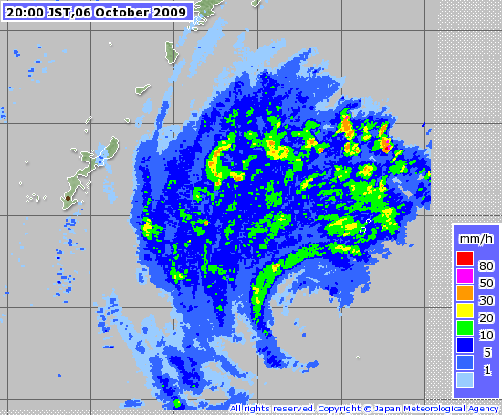
This track is really bad for Japan, especially at the coast from central to northeast. It could quite possibly strafe the coast from the Kii peninsula all the way up. Yikes! Just have to hope it weakens more quickly.
0 likes
-
weatherbabe
- Tropical Wave

- Posts: 3
- Joined: Tue Oct 06, 2009 3:27 am

-
alan1961
- Category 2
- Posts: 767
- Joined: Mon Mar 20, 2006 11:58 am
- Location: Derby, Derbyshire, England
- Contact:
Re: WPAC : TYPHOON MELOR (20W)
Typhoon Melor weakens on track to Japan
Melor has weakened from a super typhoon to a typhoon but is still packing dangerous wind speeds of 138 mph (222km/h) with gusts to 167mph (268km/h).
The storm, whose name means jasmine in Malay, is heading north-west to Japan where it will strike the southern islands of Okinawa on Wednesday and the main island of Honshu on Thursday. Residents are bracing themselves for heavy rains, violent winds and rough seas.
In a phenomenon known as the Fujiwara effect, the presence of typhoon Melor is keeping tropical storm Parma virtually stationary off the north-west coast of the Philippines.
http://news.bbc.co.uk/weather/hi/news/n ... 291084.stm
0 likes
-
jconsor
- Professional-Met
- Posts: 532
- Joined: Mon Jun 30, 2008 9:31 pm
- Location: Jerusalem, Israel
- Contact:
Re: Re:
Conditions are deteriorating rapidly on Minamidaito:
At 12z: Heavy rain showers, E winds at 69 mph, with pressure down to 28.73" (973 mb)
http://www.wunderground.com/history/sta ... atename=NA
At 12z: Heavy rain showers, E winds at 69 mph, with pressure down to 28.73" (973 mb)
http://www.wunderground.com/history/sta ... atename=NA
helmingstay wrote:
Incidentally, are there really 1,500 people on Minamidaitō right now (http://en.wikipedia.org/wiki/Minami_Daito)? If so, they're getting pounded.
0 likes
-
jconsor
- Professional-Met
- Posts: 532
- Joined: Mon Jun 30, 2008 9:31 pm
- Location: Jerusalem, Israel
- Contact:
Re:
Outflow has become much less defined during the past 6 hours, but Melor has managed to generate a new burst of convection around the center. I agree that shear won't weaken Melor much since the trough is negatively tilted. However, passage over cooler water will have some weakening effect. Melor is expected to moving slower than most typhoons approaching Japan, only about 20 kt.
If Melor makes landfall on or just west of the Kii peninsula and tracks west of Kyoto and Osaka even as a 100 kt typhoon, it would produce major damage, probably similar to Typhoon Mireille in 1991. Despite the JTWC advisories putting Melor at 115 kt, satellite suggests an intensity closer to 100-105 kt now. I expect about 90-95 kt at landfall.
If Melor makes landfall on or just west of the Kii peninsula and tracks west of Kyoto and Osaka even as a 100 kt typhoon, it would produce major damage, probably similar to Typhoon Mireille in 1991. Despite the JTWC advisories putting Melor at 115 kt, satellite suggests an intensity closer to 100-105 kt now. I expect about 90-95 kt at landfall.
Derek Ortt wrote:I don't see much shear with this, however. The outflow is very well defined in all directions yet.
I suspect it will hold its own, possibly re-intensifies as the eye contracts a little during the next 24, then slowly weaken on final approach. Probably 100KT 1 minute sustained or 85KT 10 minute as JMA has
0 likes
-
HURAKAN
- Professional-Met
- Posts: 46086
- Age: 37
- Joined: Thu May 20, 2004 4:34 pm
- Location: Key West, FL
- Contact:
ZCZC 838
WTPQ22 RJTD 061200
RSMC TROPICAL CYCLONE ADVISORY
NAME TY 0918 MELOR (0918)
ANALYSIS
PSTN 061200UTC 25.1N 130.7E FAIR
MOVE N 12KT
PRES 940HPA
MXWD 085KT
GUST 120KT
50KT 90NM
30KT 260NM EAST 230NM WEST
FORECAST
24HF 071200UTC 30.7N 133.0E 85NM 70%
MOVE NNE 16KT
PRES 945HPA
MXWD 080KT
GUST 115KT
48HF 081200UTC 38.3N 138.7E 180NM 70%
MOVE NNE 22KT
PRES 960HPA
MXWD 075KT
GUST 105KT
72HF 091200UTC 43.6N 146.4E 250NM 70%
MOVE NE 20KT
PRES 980HPA
MXWD 055KT
GUST 080KT =
NNNN
0 likes
-
jconsor
- Professional-Met
- Posts: 532
- Joined: Mon Jun 30, 2008 9:31 pm
- Location: Jerusalem, Israel
- Contact:
Re: Re:
Conditions at 15z on Minamidaito:
Heavy rain showers, SE winds at 84 mph, pressure at 28.24" (956 mb). Based on satellite estimates, Melor is centered about 30 miles due west of Minamidaito at 15z.
[quote="jconsor"]Conditions are deteriorating rapidly on Minamidaito:
At 12z: Heavy rain showers, E winds at 69 mph, with pressure down to 28.73" (973 mb)
http://www.wunderground.com/history/sta ... atename=NA
0 likes
-
HURAKAN
- Professional-Met
- Posts: 46086
- Age: 37
- Joined: Thu May 20, 2004 4:34 pm
- Location: Key West, FL
- Contact:

SUBJ: TYPHOON 20W (MELOR) WARNING NR 030
WTPN34 PGTW 061500
1. TYPHOON 20W (MELOR) WARNING NR 030
02 ACTIVE TROPICAL CYCLONES IN NORTHWESTPAC
MAX SUSTAINED WINDS BASED ON ONE-MINUTE AVERAGE
WIND RADII VALID OVER OPEN WATER ONLY
---
WARNING POSITION:
061200Z --- NEAR 25.2N 130.6E
MOVEMENT PAST SIX HOURS - 345 DEGREES AT 14 KTS
POSITION ACCURATE TO WITHIN 060 NM
POSITION BASED ON CENTER LOCATED BY SATELLITE
PRESENT WIND DISTRIBUTION:
MAX SUSTAINED WINDS - 110 KT, GUSTS 135 KT
WIND RADII VALID OVER OPEN WATER ONLY
RADIUS OF 064 KT WINDS - 095 NM NORTHEAST QUADRANT
095 NM SOUTHEAST QUADRANT
070 NM SOUTHWEST QUADRANT
075 NM NORTHWEST QUADRANT
RADIUS OF 050 KT WINDS - 125 NM NORTHEAST QUADRANT
125 NM SOUTHEAST QUADRANT
100 NM SOUTHWEST QUADRANT
125 NM NORTHWEST QUADRANT
RADIUS OF 034 KT WINDS - 175 NM NORTHEAST QUADRANT
165 NM SOUTHEAST QUADRANT
145 NM SOUTHWEST QUADRANT
165 NM NORTHWEST QUADRANT
REPEAT POSIT: 25.2N 130.6E
---
FORECASTS:
12 HRS, VALID AT:
070000Z --- 28.2N 131.2E
MAX SUSTAINED WINDS - 095 KT, GUSTS 115 KT
WIND RADII VALID OVER OPEN WATER ONLY
RADIUS OF 064 KT WINDS - 070 NM NORTHEAST QUADRANT
070 NM SOUTHEAST QUADRANT
055 NM SOUTHWEST QUADRANT
055 NM NORTHWEST QUADRANT
RADIUS OF 050 KT WINDS - 105 NM NORTHEAST QUADRANT
105 NM SOUTHEAST QUADRANT
085 NM SOUTHWEST QUADRANT
105 NM NORTHWEST QUADRANT
RADIUS OF 034 KT WINDS - 175 NM NORTHEAST QUADRANT
170 NM SOUTHEAST QUADRANT
150 NM SOUTHWEST QUADRANT
165 NM NORTHWEST QUADRANT
VECTOR TO 24 HR POSIT: 035 DEG/ 19 KTS
---
24 HRS, VALID AT:
071200Z --- 31.4N 133.7E
MAX SUSTAINED WINDS - 085 KT, GUSTS 105 KT
WIND RADII VALID OVER OPEN WATER ONLY
BECOMING EXTRATROPICAL
RADIUS OF 064 KT WINDS - 055 NM NORTHEAST QUADRANT
055 NM SOUTHEAST QUADRANT
045 NM SOUTHWEST QUADRANT
045 NM NORTHWEST QUADRANT
RADIUS OF 050 KT WINDS - 090 NM NORTHEAST QUADRANT
090 NM SOUTHEAST QUADRANT
075 NM SOUTHWEST QUADRANT
085 NM NORTHWEST QUADRANT
RADIUS OF 034 KT WINDS - 170 NM NORTHEAST QUADRANT
170 NM SOUTHEAST QUADRANT
155 NM SOUTHWEST QUADRANT
165 NM NORTHWEST QUADRANT
VECTOR TO 36 HR POSIT: 040 DEG/ 24 KTS
---
36 HRS, VALID AT:
080000Z --- 35.1N 137.3E
MAX SUSTAINED WINDS - 070 KT, GUSTS 085 KT
WIND RADII VALID OVER OPEN WATER ONLY
BECOMING EXTRATROPICAL
VECTOR TO 48 HR POSIT: 040 DEG/ 25 KTS
---
EXTENDED OUTLOOK:
48 HRS, VALID AT:
081200Z --- 38.7N 141.6E
MAX SUSTAINED WINDS - 050 KT, GUSTS 065 KT
WIND RADII VALID OVER OPEN WATER ONLY
EXTRATROPICAL
VECTOR TO 72 HR POSIT: 045 DEG/ 28 KTS
---
72 HRS, VALID AT:
091200Z --- 45.8N 153.5E
MAX SUSTAINED WINDS - 035 KT, GUSTS 045 KT
WIND RADII VALID OVER OPEN WATER ONLY
EXTRATROPICAL
---
REMARKS:
061500Z POSITION NEAR 26.0N 130.7E.
MAXIMUM SIGNIFICANT WAVE HEIGHT AT 061200Z IS 38 FEET.
NEXT WARNINGS AT 062100Z, 070300Z, 070900Z AND 071500Z.
REFER TO TROPICAL STORM 19W (PARMA) WARNINGS (WTPN33 PGTW)
FOR SIX-HOURLY UPDATES.
//
BT
#0001
NNNN
0 likes

Just checking in to say we're okay here...though it is 3:30 a.m. and I am just now ready to get to bed. The noise level has died down some outside. Some video I took earlier before it got very intense: http://www.youtube.com/watch?v=YmfBjflIBXo
0 likes
-
ozonepete
- Professional-Met
- Posts: 4743
- Joined: Mon Sep 07, 2009 3:23 pm
- Location: From Ozone Park, NYC / Now in Brooklyn, NY
Re: Re:
jconsor wrote:Outflow has become much less defined during the past 6 hours, but Melor has managed to generate a new burst of convection around the center. I agree that shear won't weaken Melor much since the trough is negatively tilted. However, passage over cooler water will have some weakening effect. Melor is expected to moving slower than most typhoons approaching Japan, only about 20 kt.
If Melor makes landfall on or just west of the Kii peninsula and tracks west of Kyoto and Osaka even as a 100 kt typhoon, it would produce major damage, probably similar to Typhoon Mireille in 1991. Despite the JTWC advisories putting Melor at 115 kt, satellite suggests an intensity closer to 100-105 kt now. I expect about 90-95 kt at landfall.Derek Ortt wrote:I don't see much shear with this, however. The outflow is very well defined in all directions yet.
I suspect it will hold its own, possibly re-intensifies as the eye contracts a little during the next 24, then slowly weaken on final approach. Probably 100KT 1 minute sustained or 85KT 10 minute as JMA has
Great analysis. Seems right to me. The interesting thing is the JMA and JTWC are very close on landfall now at the Kii peninsula, but diverge fairly significantly after that, with JMA track putting most of JAPAN in the dangerous right side while JTWC keeps mostly just the coast in the right front quadrant.
0 likes
-
ozonepete
- Professional-Met
- Posts: 4743
- Joined: Mon Sep 07, 2009 3:23 pm
- Location: From Ozone Park, NYC / Now in Brooklyn, NY
Re: WPAC : TYPHOON MELOR (20W)
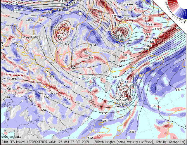
I still have reservations about the JMA forecast though, AFTER landfall. Look at the GFS forecast chart for 500mb heights for tomorrow morning. (Sorry it is a little hard to read. Why can't we get better upper air charts for Asia?) Anyway, you have rising heights over the Sea of Japan west of northern Japan and falling heights to the east, i.e. the westerlies (500mb a good proxy for steering level at this latitude) are coming straight into northern Japan. It makes it hard for me to envision this cyclone making it over the western side of Japan after landfall. I also drew in the mid to upper level winds coming over Korea into Japan. If you watch the satellite loop you'll see it quite clearly. All of this just makes me think the JMA is not recurving it sharply enough. Just my thoughts. And I know you guys (Derek and Jconsor) explained the problem with JTWC (thanks for the inside info) but as they say, even a stopped clock is right twice a day... 
0 likes
-
ozonepete
- Professional-Met
- Posts: 4743
- Joined: Mon Sep 07, 2009 3:23 pm
- Location: From Ozone Park, NYC / Now in Brooklyn, NY
Re: WPAC : TYPHOON MELOR (20W)
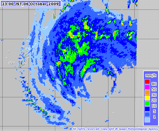
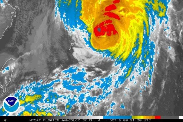
Though the eye is obscured, there's a lot of strong convection building just before daylight.
0 likes
Who is online
Users browsing this forum: No registered users and 30 guests