ATL : TROPICAL STORM GRACE

Moderator: S2k Moderators

Message
Author
User avatar
Macrocane
Category 5
Category 5
Posts: 4218
Age: 35
Joined: Sun May 24, 2009 5:35 pm
Location: El Salvador

Re: ATL : Invest 90L

#21 Postby Macrocane » Thu Oct 01, 2009 12:27 pm

HURAKAN wrote:
The other system was in June and we know that the SST at that time of the year aren't warm enough to support a tropical or subtropical system. Still, it doesn't mean that the system could have been subtropical.


That's very true I remember that SST were very cold for supporting tropical development. It would be great if this system becomes Sub-TS or TS Grace just to have another named storm this season, I hope that everyone is OK in the Azores.
0 likes   

CrazyC83
Professional-Met
Professional-Met
Posts: 33393
Joined: Tue Mar 07, 2006 11:57 pm
Location: Deep South, for the first time!

#22 Postby CrazyC83 » Thu Oct 01, 2009 12:29 pm

Might want to start advisories on Grace now.

With that wind trend, the pressure is probably 986mb. I'd set the winds at 55 kt given the pressure and look.
0 likes   

CrazyC83
Professional-Met
Professional-Met
Posts: 33393
Joined: Tue Mar 07, 2006 11:57 pm
Location: Deep South, for the first time!

Re: ATL : Invest 90L

#23 Postby CrazyC83 » Thu Oct 01, 2009 12:31 pm

HURAKAN wrote:
Macrocane wrote:This is a surprise to me :eek: Maybe code yellow leter today.


It should be Orange if not Red.


More like a Special Advisory should come out now.
0 likes   

User avatar
HURAKAN
Professional-Met
Professional-Met
Posts: 46086
Age: 37
Joined: Thu May 20, 2004 4:34 pm
Location: Key West, FL
Contact:

#24 Postby HURAKAN » Thu Oct 01, 2009 12:32 pm

Horta, Azores: http://www.wunderground.com/global/stations/08506.html

29.20 in or 988.9 mb

The pressure in the city dropped 3 mb in one hour
0 likes   

CrazyC83
Professional-Met
Professional-Met
Posts: 33393
Joined: Tue Mar 07, 2006 11:57 pm
Location: Deep South, for the first time!

#25 Postby CrazyC83 » Thu Oct 01, 2009 12:34 pm

If this becomes Grace, she will have caught all of us - everyone on here AND the NHC - napping.
0 likes   

User avatar
RattleMan
Category 5
Category 5
Posts: 1218
Joined: Wed Aug 24, 2005 7:14 pm
Location: Phoenix, AZ

Re: ATL : Invest 90L

#26 Postby RattleMan » Thu Oct 01, 2009 12:34 pm

000
ABNT20 KNHC 011732
TWOAT
TROPICAL WEATHER OUTLOOK
NWS TPC/NATIONAL HURRICANE CENTER MIAMI FL
200 PM EDT THU OCT 1 2009

FOR THE NORTH ATLANTIC...CARIBBEAN SEA AND THE GULF OF MEXICO...

SHOWER ACTIVITY HAS INCREASED NEAR THE CENTER OF A NON-TROPICAL
LOW PRESSURE AREA MOVING NORTHWARD THROUGH THE CENTRAL AZORES
ISLANDS. DEVELOPMENT OF THIS SYSTEM IS NOT ANTICIPATED...AND THERE
IS A LOW CHANCE...LESS THAN 30 PERCENT...OF THIS SYSTEM BECOMING A
SUBTROPICAL OR TROPICAL CYCLONE DURING THE NEXT 48 HOURS.

ELSEWHERE...TROPICAL CYCLONE FORMATION IS NOT EXPECTED DURING THE
NEXT 48 HOURS.

$$
FORECASTER BROWN
0 likes   

CrazyC83
Professional-Met
Professional-Met
Posts: 33393
Joined: Tue Mar 07, 2006 11:57 pm
Location: Deep South, for the first time!

#27 Postby CrazyC83 » Thu Oct 01, 2009 12:36 pm

Temperature at that station is 20C, so it is probably warm-core...

It is also clearly non-frontal, so extratropical is definitely wrong.
0 likes   

User avatar
HURAKAN
Professional-Met
Professional-Met
Posts: 46086
Age: 37
Joined: Thu May 20, 2004 4:34 pm
Location: Key West, FL
Contact:

#28 Postby HURAKAN » Thu Oct 01, 2009 12:38 pm

Image

Very nice microwave image
0 likes   

CrazyC83
Professional-Met
Professional-Met
Posts: 33393
Joined: Tue Mar 07, 2006 11:57 pm
Location: Deep South, for the first time!

#29 Postby CrazyC83 » Thu Oct 01, 2009 12:39 pm

How would everyone else classify this? Given the central convection, I'd go ahead and call this Tropical Storm Grace personally...

This would be hilarious if it became named. We didn't even MENTION it until it became an Invest, neither did the NHC, it would be like this came out of our sleeps!!! I didn't even know it existed either!

Could this also be ex-TD8?
0 likes   

Derek Ortt

#30 Postby Derek Ortt » Thu Oct 01, 2009 12:51 pm

non-tropical?

This is non-frontal and at least looks to have a flat temperature gradient
0 likes   

User avatar
Macrocane
Category 5
Category 5
Posts: 4218
Age: 35
Joined: Sun May 24, 2009 5:35 pm
Location: El Salvador

Re:

#31 Postby Macrocane » Thu Oct 01, 2009 12:56 pm

CrazyC83 wrote:How would everyone else classify this? Given the central convection, I'd go ahead and call this Tropical Storm Grace personally...

This would be hilarious if it became named. We didn't even MENTION it until it became an Invest, neither did the NHC, it would be like this came out of our sleeps!!! I didn't even know it existed either!

Could this also be ex-TD8?


It may be related if that's the trough that absorbed the enrgy from TD-8 but I'm not sure if it is, in any case the system is now separeted from the trough so it's not directly ex-TD-8. By the way, as I expected the NHC gave code yellow to this system even if it looks pretty good.
0 likes   

User avatar
wxman57
Moderator-Pro Met
Moderator-Pro Met
Posts: 22482
Age: 66
Joined: Sat Jun 21, 2003 8:06 pm
Location: Houston, TX (southwest)

Re: ATL : Invest 90L

#32 Postby wxman57 » Thu Oct 01, 2009 12:59 pm

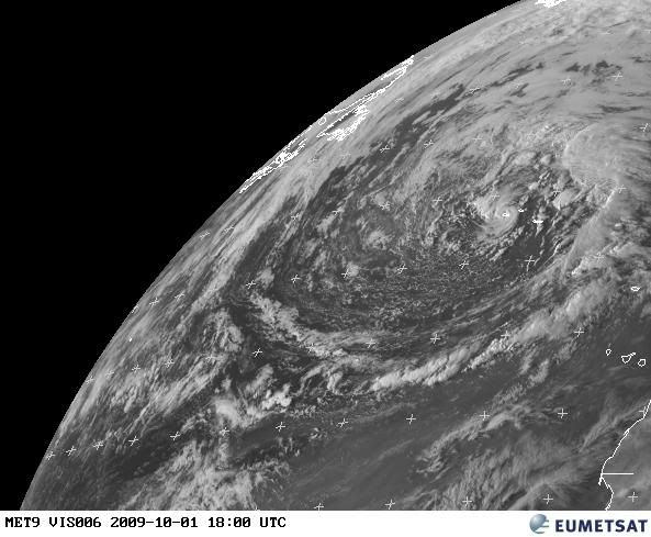
We've seen TCs develop in the core of large extratropical lows in the past. The Halloween hurricane of 1991 would be an example. SSTs near the Azores are about 22C. A bit chilly, but not too cold for a hybrid type storm. This low is no longer frontal, as it's well-separated from the occluded front. That feature which looks like an eye probably isn't indicative of it being a hurricane. I don't think it's a true eye. Surface obs in the area are only in the 20-25 kt range across the Azores, with higher winds 300-400 miles to the north and east. This morning's QS had a gap right through the Azores, but did show a number of 30kt winds around the perimeter of the low.

Should it be named? First we'd need some evidence that it is producing TS winds. No data to support that now, nor is there data to confirm it doesn't have TS winds. It doesn't have any deep convection around the center, so that's an argument against classifying it as tropical. Maybe an STS if winds of 39 mph are indicated.

It'll probably hang around the Azores for a few days before accelerating off to the NE over much colder water.

Here's a surface plot:
Image
0 likes   

User avatar
wxman57
Moderator-Pro Met
Moderator-Pro Met
Posts: 22482
Age: 66
Joined: Sat Jun 21, 2003 8:06 pm
Location: Houston, TX (southwest)

Re:

#33 Postby wxman57 » Thu Oct 01, 2009 1:02 pm

CrazyC83 wrote:
Could this also be ex-TD8?


On a 3-day satellite loop yesterday, we could see ex TD8 racing westward, passing west of 55W about 48 hours ago. Some residual vorticity appears to be around 25N/65W, but it's barely identifiable. So it's not the vorticity related to TD8. It's just a the core of a very large extratropical cyclone that's associated with an occluded front. The frontal boundary is now well away from the core.
0 likes   

User avatar
cycloneye
Admin
Admin
Posts: 139212
Age: 67
Joined: Thu Oct 10, 2002 10:54 am
Location: San Juan, Puerto Rico

Re: ATL : Invest 90L

#34 Postby cycloneye » Thu Oct 01, 2009 1:08 pm

Floater 1 over it.

Image
0 likes   
Visit the Caribbean-Central America Weather Thread where you can find at first post web cams,radars
and observations from Caribbean basin members Click Here

User avatar
HURAKAN
Professional-Met
Professional-Met
Posts: 46086
Age: 37
Joined: Thu May 20, 2004 4:34 pm
Location: Key West, FL
Contact:

#35 Postby HURAKAN » Thu Oct 01, 2009 1:11 pm

Horta, Azores: http://www.wunderground.com/global/stations/08506.html

29.10 in or 985.5 mb

The pressure in the city dropped 3.4 mb in one hour
0 likes   

User avatar
wxman57
Moderator-Pro Met
Moderator-Pro Met
Posts: 22482
Age: 66
Joined: Sat Jun 21, 2003 8:06 pm
Location: Houston, TX (southwest)

Re: ATL : Invest 90L

#36 Postby wxman57 » Thu Oct 01, 2009 1:16 pm

Here's a wider view with a surface analysis. True, it's not exactly "on" a front, but it is the center of a large occluded low. In other cases where occluded low centers have developed into TCs, the SSTs have been warmer:

Image
0 likes   

CrazyC83
Professional-Met
Professional-Met
Posts: 33393
Joined: Tue Mar 07, 2006 11:57 pm
Location: Deep South, for the first time!

#37 Postby CrazyC83 » Thu Oct 01, 2009 1:18 pm

Notice the wind gusts at that station were 50 mph, yet it came to a dead calm - signs of a well-defined eye. I've never heard of a TD/STD over water with a pressure of 985mb either.
0 likes   

User avatar
wxman57
Moderator-Pro Met
Moderator-Pro Met
Posts: 22482
Age: 66
Joined: Sat Jun 21, 2003 8:06 pm
Location: Houston, TX (southwest)

Re:

#38 Postby wxman57 » Thu Oct 01, 2009 1:24 pm

CrazyC83 wrote:Notice the wind gusts at that station were 50 mph, yet it came to a dead calm - signs of a well-defined eye. I've never heard of a TD/STD over water with a pressure of 985mb either.


I think there's an error. If you look at the actual station data, you see that the wind gust was 49 KPH, not mph. That's about 30-31 mph.

http://www.wunderground.com/history/sta ... story.html
Last edited by wxman57 on Thu Oct 01, 2009 1:25 pm, edited 1 time in total.
0 likes   

User avatar
HURAKAN
Professional-Met
Professional-Met
Posts: 46086
Age: 37
Joined: Thu May 20, 2004 4:34 pm
Location: Key West, FL
Contact:

#39 Postby HURAKAN » Thu Oct 01, 2009 1:24 pm

Image

Latest
0 likes   

User avatar
brunota2003
S2K Supporter
S2K Supporter
Posts: 9476
Age: 33
Joined: Sat Jul 30, 2005 9:56 pm
Location: Stanton, KY...formerly Havelock, NC
Contact:

Re:

#40 Postby brunota2003 » Thu Oct 01, 2009 1:25 pm

CrazyC83 wrote:Notice the wind gusts at that station were 50 mph, yet it came to a dead calm - signs of a well-defined eye. I've never heard of a TD/STD over water with a pressure of 985mb either.

But also notice, the temperature peaked at 4 pm and has been falling since, as the pressure continues to fall (now 6 pm). Clearly cold cored.
0 likes   


Return to “2009”

Who is online

Users browsing this forum: No registered users and 45 guests