
EPAC : TROPICAL DEPRESSION RICK (20E)
Moderator: S2k Moderators
-
tolakram
- Admin

- Posts: 19165
- Age: 60
- Joined: Sun Aug 27, 2006 8:23 pm
- Location: Florence, KY (name is Mark)
Re: EPAC : INVEST 93E
Someone turned off the shear. I wonder if this has a good chance to become a major?
0 likes
M a r k
- - - - -
Join us in chat: Storm2K Chatroom Invite. Android and IOS apps also available.
The posts in this forum are NOT official forecasts and should not be used as such. Posts are NOT endorsed by any professional institution or STORM2K.org. For official information and forecasts, please refer to NHC and NWS products.
-
cycloneye

- Admin
- Posts: 139127
- Age: 67
- Joined: Thu Oct 10, 2002 10:54 am
- Location: San Juan, Puerto Rico
Re: EPAC : INVEST 93E
This was quick!!
BEGIN
NHC_ATCF
invest_RENUMBER_ep932009_ep202009.ren
FSTDA
R
U
040
010
0000
200910151835
NONE
NOTIFY=ATRP
BEGIN
NHC_ATCF
invest_RENUMBER_ep932009_ep202009.ren
FSTDA
R
U
040
010
0000
200910151835
NONE
NOTIFY=ATRP
0 likes
Visit the Caribbean-Central America Weather Thread where you can find at first post web cams,radars
and observations from Caribbean basin members Click Here
and observations from Caribbean basin members Click Here
-
cycloneye
- Admin
- Posts: 139127
- Age: 67
- Joined: Thu Oct 10, 2002 10:54 am
- Location: San Juan, Puerto Rico
Re: EPAC : INVEST 93E
WHXX01 KMIA 151843
CHGE77
TROPICAL CYCLONE GUIDANCE MESSAGE
NWS TPC/NATIONAL HURRICANE CENTER MIAMI FL
1843 UTC THU OCT 15 2009
DISCLAIMER...NUMERICAL MODELS ARE SUBJECT TO LARGE ERRORS.
PLEASE REFER TO NHC OFFICIAL FORECASTS FOR TROPICAL CYCLONE
AND SUBTROPICAL CYCLONE INFORMATION.
EAST PACIFIC OBJECTIVE AIDS FOR
TROPICAL CYCLONE TWENTY (EP202009) 20091015 1800 UTC
...00 HRS... ...12 HRS... ...24 HRS. .. ...36 HRS...
091015 1800 091016 0600 091016 1800 091017 0600
LAT LON LAT LON LAT LON LAT LON
BAMS 11.9N 96.6W 12.7N 97.9W 13.1N 99.3W 13.6N 101.2W
BAMD 11.9N 96.6W 12.5N 98.1W 13.0N 99.5W 13.5N 101.0W
BAMM 11.9N 96.6W 12.6N 98.1W 13.1N 99.5W 13.6N 101.3W
LBAR 11.9N 96.6W 12.8N 98.4W 13.5N 100.3W 14.2N 102.4W
SHIP 30KTS 39KTS 55KTS 68KTS
DSHP 30KTS 39KTS 55KTS 68KTS
...48 HRS... ...72 HRS... ...96 HRS. .. ..120 HRS...
091017 1800 091018 1800 091019 1800 091020 1800
LAT LON LAT LON LAT LON LAT LON
BAMS 14.2N 103.7W 15.5N 109.4W 16.0N 114.0W 15.1N 113.8W
BAMD 14.2N 102.7W 16.1N 107.0W 18.5N 111.1W 20.4N 113.7W
BAMM 14.2N 103.3W 15.8N 108.3W 17.2N 112.8W 17.1N 114.6W
LBAR 15.1N 104.4W 16.7N 107.8W 18.3N 110.7W 19.2N 112.6W
SHIP 82KTS 101KTS 111KTS 111KTS
DSHP 82KTS 101KTS 111KTS 111KTS
...INITIAL CONDITIONS...
LATCUR = 11.9N LONCUR = 96.6W DIRCUR = 310DEG SPDCUR = 13KT
LATM12 = 10.2N LONM12 = 94.5W DIRM12 = 320DEG SPDM12 = 13KT
LATM24 = 7.8N LONM24 = 93.2W
WNDCUR = 30KT RMAXWD = 60NM WNDM12 = 25KT
CENPRS = 1005MB OUTPRS = 1012MB OUTRAD = 200NM SDEPTH = D
RD34NE = 0NM RD34SE = 0NM RD34SW = 0NM RD34NW = 0NM
0 likes
Visit the Caribbean-Central America Weather Thread where you can find at first post web cams,radars
and observations from Caribbean basin members Click Here
and observations from Caribbean basin members Click Here

-
tolakram
- Admin
- Posts: 19165
- Age: 60
- Joined: Sun Aug 27, 2006 8:23 pm
- Location: Florence, KY (name is Mark)
Re: EPAC : INVEST 93E
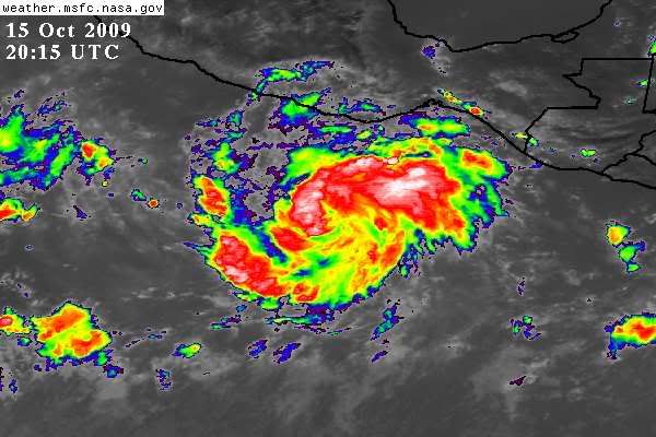
Look at this beast. Appears to be in a perfect environment.
LOOP:
http://rammb.cira.colostate.edu/ramsdis ... _floater_1

LOOP:
http://rammb.cira.colostate.edu/ramsdis ... _floater_1
0 likes
M a r k
- - - - -
Join us in chat: Storm2K Chatroom Invite. Android and IOS apps also available.
The posts in this forum are NOT official forecasts and should not be used as such. Posts are NOT endorsed by any professional institution or STORM2K.org. For official information and forecasts, please refer to NHC and NWS products.
- - - - -
Join us in chat: Storm2K Chatroom Invite. Android and IOS apps also available.
The posts in this forum are NOT official forecasts and should not be used as such. Posts are NOT endorsed by any professional institution or STORM2K.org. For official information and forecasts, please refer to NHC and NWS products.
-
srainhoutx

- S2K Supporter

- Posts: 6919
- Age: 66
- Joined: Sun Jan 14, 2007 11:34 am
- Location: Haywood County, NC
- Contact:
Re: EPAC : INVEST 93E
Noticed the EC is showing an Kenna type system re: strength and landfall.
0 likes
Carla/Alicia/Jerry(In The Eye)/Michelle/Charley/Ivan/Dennis/Katrina/Rita/Wilma/Ike/Harvey
Member: National Weather Association
Wx Infinity Forums
http://wxinfinity.com/index.php
Facebook.com/WeatherInfinity
Twitter @WeatherInfinity
Member: National Weather Association
Wx Infinity Forums
http://wxinfinity.com/index.php
Facebook.com/WeatherInfinity
Twitter @WeatherInfinity
-
HURAKAN

- Professional-Met

- Posts: 46086
- Age: 37
- Joined: Thu May 20, 2004 4:34 pm
- Location: Key West, FL
- Contact:
648
WTPZ35 KNHC 152039
TCPEP5
BULLETIN
TROPICAL DEPRESSION TWENTY-E ADVISORY NUMBER 1
NWS TPC/NATIONAL HURRICANE CENTER MIAMI FL EP202009
200 PM PDT THU OCT 15 2009
...TROPICAL DEPRESSION TWENTY-E FORMS SOUTH OF MEXICO...FORECAST TO
STRENGTHEN...
AT 200 PM PDT...2100 UTC...THE CENTER OF TROPICAL DEPRESSION
TWENTY-E WAS LOCATED NEAR LATITUDE 12.1 NORTH...LONGITUDE 97.0 WEST
OR ABOUT 385 MILES...620 KM...SOUTH-SOUTHEAST OF ACAPULCO MEXICO.
THE DEPRESSION IS MOVING TOWARD THE NORTHWEST NEAR 13 MPH...
24 KM/HR. A TURN TOWARD THE WEST-NORTHWEST AND A DECREASE IN
FORWARD SPEED ARE EXPECTED DURING THE NEXT COUPLE OF DAYS.
MAXIMUM SUSTAINED WINDS ARE NEAR 35 MPH...55 KM/HR...WITH HIGHER
GUSTS. STRENGTHENING IS FORECAST DURING THE NEXT COUPLE OF
DAYS...AND THE DEPRESSION IS EXPECTED TO BECOME A TROPICAL STORM
LATER TONIGHT OR FRIDAY.
ESTIMATED MINIMUM CENTRAL PRESSURE IS 1005 MB...29.68 INCHES.
...SUMMARY OF 200 PM PDT INFORMATION...
LOCATION...12.1N 97.0W
MAXIMUM SUSTAINED WINDS...35 MPH
PRESENT MOVEMENT...NORTHWEST OR 305 DEGREES AT 13 MPH
MINIMUM CENTRAL PRESSURE...1005 MB
THE NEXT ADVISORY WILL BE ISSUED BY THE NATIONAL HURRICANE CENTER AT
800 PM PDT.
$$
FORECASTER BEVEN
140
WTPZ45 KNHC 152039
TCDEP5
TROPICAL DEPRESSION TWENTY-E DISCUSSION NUMBER 1
NWS TPC/NATIONAL HURRICANE CENTER MIAMI FL EP202009
200 PM PDT THU OCT 15 2009
CONVENTIONAL SATELLITE IMAGERY...DATA FROM THE ASCAT
SCATTEROMETER...AND SHIP REPORTS INDICATE THAT THE LOW PRESSURE
AREA CENTERED SOUTH OF MEXICO HAS ACQUIRED SUFFICIENT ORGANIZED
CONVECTION AND CIRCULATION TO BE DESIGNATED A TROPICAL DEPRESSION.
THE ASCAT DATA SHOWED MAXIMUM WINDS NEAR 30 KT ABOUT 60 N MI
NORTH-NORTHEAST OF THE CENTER...WHICH IS IN GOOD AGREEMENT WITH
SATELLITE INTENSITY ESTIMATES FROM TAFB AND SAB. THE CIRRUS
OUTFLOW IS CURRENTLY GOOD IN ALL DIRECTIONS.
THE INITIAL MOTION IS A SOMEWHAT UNCERTAIN 305/11. THE DEPRESSION
IS ON THE SOUTH SIDE OF A LOW/MID-LEVEL RIDGE EXTENDING FROM MEXICO
WESTWARD OVER THE PACIFIC. THE LARGE-SCALE MODELS FORECAST THIS
FEATURE TO PERSIST FOR THE NEXT 48-72 HR...AND THIS SHOULD STEER
THE DEPRESSION WEST-NORTHWESTWARD AT A SLIGHTLY SLOWER FORWARD
SPEED. AFTER THAT TIME...THE RIDGE IS FORECAST TO WEAKEN AS A
MID/UPPER-LEVEL TROUGH DEVELOPS OVER THE WESTERN UNITED STATES.
THE TRACK GUIDANCE DIVERGES DURING THIS TIME. THE HWRF AND GFDL...
WHICH ARE ON THE RIGHT SIDE OF THE GUIDANCE ENVELOPE...TURN THE
CYCLONE TO THE NORTH OR NORTHEAST BY 120 HR...WITH THE GFDL
FORECASTING THE CENTER TO BE NEAR SOUTHERN BAJA CALIFORNIA. THE
NOGAPS...CANADIAN...AND UKMET ARE ON THE OTHER SIDE OF THE
ENVELOPE...AND SHOW A SLOW WEST-NORTHWESTWARD MOTION AFTER 72 HR.
THE GFS AND ECMWF ARE IN BETWEEN THESE EXTREMES...WITH 120 HR
POSITIONS JUST SOUTH OR SOUTHWEST OF SOCORRO ISLAND. THE FORECAST
TRACK COMPROMISES BETWEEN THESE EXTREMES...WITH THE TRACK IN BEST
AGREEMENT WITH THE TVCN CONSENSUS MODEL FOR THE FIRST 72 HR AND
WITH THE GFS/ECMWF THEREAFTER.
THE DEPRESSION IS EMBEDDED IN A LIGHT VERTICAL WIND SHEAR
ENVIRONMENT OVER VERY WARM WATER...AND THE LARGE-SCALE MODELS
FORECAST THIS TO CONTINUE THROUGH AT LEAST 72 HR. ALL GUIDANCE IS
FORECASTING SIGNIFICANT AND RAPID STRENGTHENING DURING THE NEXT
72-96 HR...WITH THE HWRF FORECASTING THE CENTRAL PRESSURE TO FALL
BELOW 900 MB. THE RAPID INTENSIFICATION INDEX OF THE SHIPS MODEL
INDICATES A 60 PERCENT CHANCE OF 30 KT OR MORE INTENSIFICATION
DURING THE NEXT 24 HR. THE INTENSITY FORECAST THUS CALLS FOR FAST
STRENGTHENING...WITH THE DEPRESSION BECOMING A TROPICAL STORM BY
12 HR...A HURRICANE IN ABOUT 36 HR...AND A MAJOR HURRICANE IN ABOUT
72 HR. THE INTENSITY FORECAST IS SIMILAR TO THE SHIPS AND
INTENSITY CONSENSUS MODELS. THERE IS A CHANCE THAT THE CYCLONE
COULD STRENGTHEN FASTER THAN CURRENTLY FORECAST.
THE INITIAL RADII OF 12 FT SEAS ARE BASED ON TWO SHIP REPORTS
130 AND 170 N MI FROM THE CENTER IN THE EASTERN SEMICIRCLE.
FORECAST POSITIONS AND MAX WINDS
INITIAL 15/2100Z 12.1N 97.0W 30 KT
12HR VT 16/0600Z 12.6N 98.2W 40 KT
24HR VT 16/1800Z 13.0N 99.7W 55 KT
36HR VT 17/0600Z 13.4N 101.3W 65 KT
48HR VT 17/1800Z 13.9N 103.3W 80 KT
72HR VT 18/1800Z 15.0N 108.0W 100 KT
96HR VT 19/1800Z 17.0N 111.5W 110 KT
120HR VT 20/1800Z 19.0N 112.5W 115 KT
$$
FORECASTER BEVEN
0 likes
-
HurricaneRobert
- Category 3

- Posts: 812
- Joined: Fri May 18, 2007 9:31 pm
Re: EPAC : TROPICAL DEPRESSION TWENTY-E
This looks like RI. I think its a tropical storm already.
0 likes


Re:
HURAKAN wrote:ALL GUIDANCE IS
FORECASTING SIGNIFICANT AND RAPID STRENGTHENING DURING THE NEXT
72-96 HR...WITH THE HWRF FORECASTING THE CENTRAL PRESSURE TO FALL
BELOW 900 MB.
This would make it the most intense TC in the EPAC. Linda was 902
0 likes
-
Hurricanehink

- S2K Supporter
- Posts: 2023
- Joined: Sun Nov 16, 2003 2:05 pm
- Location: New Jersey
Re: EPAC : TROPICAL DEPRESSION TWENTY-E
Wow, I've never seen any tropical depression in the Atlantic or Pacific with such an intensity forecast on the first advisory. Even Wilma's first advisory was fairly conservative.
0 likes
-
bombarderoazul
- Tropical Storm

- Posts: 186
- Joined: Tue Sep 20, 2005 4:12 pm
Re: EPAC : TROPICAL DEPRESSION TWENTY-E
Impressive! indeed this storm has the potential to overtake Jimena as the strongest cyclone in the western hemisphere and maybe even Choi-wan.
0 likes
-
HurricaneRobert
- Category 3
- Posts: 812
- Joined: Fri May 18, 2007 9:31 pm
Re: EPAC : TROPICAL DEPRESSION TWENTY-E
It will be a hurricane before then. This is the first time that little map above has had a tropical depression with those bright purple dots in front of it.
0 likes
-
cycloneye
- Admin
- Posts: 139127
- Age: 67
- Joined: Thu Oct 10, 2002 10:54 am
- Location: San Juan, Puerto Rico
Re:
CrazyC83 wrote:Is there any Recon planned in the near future? Is it too far away for them to send one tomorrow?
The evolution of this system has been very fast as it became invest around 9 AM EDT to TD this afternoon that they didnt have updated the TPOD with a tasked plane.I am sure that they will task a plane for Saturday.
WEATHER RECONNAISSANCE FLIGHTS
CARCAH, NATIONAL HURRICANE CENTER, MIAMI, FL.
0900 AM EDT THU 15 OCTOBER 2009
SUBJECT: TROPICAL CYCLONE PLAN OF THE DAY (TCPOD)
VALID 16/1100Z TO 17/1100Z 0CTOBER 2009
TCPOD NUMBER.....09-140
PACIFIC REQUIREMENTS
1. NEGATIVE RECONNAISSANCE REQUIREMENTS.
2. OUTLOOK FOR SUCCEEDING DAY.....NEGATIVE.
0 likes
Visit the Caribbean-Central America Weather Thread where you can find at first post web cams,radars
and observations from Caribbean basin members Click Here
and observations from Caribbean basin members Click Here
-
somethingfunny

- ChatStaff

- Posts: 3926
- Age: 35
- Joined: Thu May 31, 2007 10:30 pm
- Location: McKinney, Texas
-
cycloneye
- Admin
- Posts: 139127
- Age: 67
- Joined: Thu Oct 10, 2002 10:54 am
- Location: San Juan, Puerto Rico
Re: EPAC : TROPICAL DEPRESSION TWENTY-E
This looks like a mature tropical storm right now.


0 likes
Visit the Caribbean-Central America Weather Thread where you can find at first post web cams,radars
and observations from Caribbean basin members Click Here
and observations from Caribbean basin members Click Here

Who is online
Users browsing this forum: No registered users and 56 guests