ATL : TROPICAL DEPRESSION IDA
Moderator: S2k Moderators

Re: ATL : INVEST 97L=Recon for Wednesday Afternoon at 20:00Z
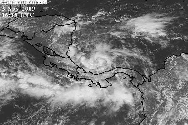
Impressive swirl. This area has been a hot spot for convection formation all season and itching to put out a system. That's about as far south as you can get a spinning system near 10N in the West Atlantic. This odd kind of location is what you would expect in an odd year like 2009.
0 likes
-
tolakram
- Admin

- Posts: 19165
- Age: 60
- Joined: Sun Aug 27, 2006 8:23 pm
- Location: Florence, KY (name is Mark)
Re: ATL : INVEST 97L=Recon for Wednesday Afternoon at 20:00Z
This may require one of those infamous 'eye like feature' comments if it continues to organize. 
0 likes
M a r k
- - - - -
Join us in chat: Storm2K Chatroom Invite. Android and IOS apps also available.
The posts in this forum are NOT official forecasts and should not be used as such. Posts are NOT endorsed by any professional institution or STORM2K.org. For official information and forecasts, please refer to NHC and NWS products.
-
ozonepete
- Professional-Met

- Posts: 4743
- Joined: Mon Sep 07, 2009 3:23 pm
- Location: From Ozone Park, NYC / Now in Brooklyn, NY
Re: ATL : INVEST 97L=Recon for Wednesday Afternoon at 20:00Z
tolakram wrote:This may require one of those infamous 'eye like feature' comments if it continues to organize.
heh heh. here we go again.
0 likes
-
HURAKAN

- Professional-Met
- Posts: 46086
- Age: 37
- Joined: Thu May 20, 2004 4:34 pm
- Location: Key West, FL
- Contact:
Re: ATL : INVEST 97L=Recon for Wednesday Afternoon at 20:00Z
ozonepete wrote:tolakram wrote:This may require one of those infamous 'eye like feature' comments if it continues to organize.
heh heh. here we go again.

No time to waste.
0 likes
-
wxman57

- Moderator-Pro Met

- Posts: 22482
- Age: 66
- Joined: Sat Jun 21, 2003 8:06 pm
- Location: Houston, TX (southwest)
Re: ATL : INVEST 97L
Not a lot of surface obs out over the water. The ones I do find are in the 10-15 kt range north of the low center. Probably some 20-25 kt winds in the shower bands. Looks more impressive than most of the named tropical storms of 2009. My current thinking is that a track inland into Central America/Nicaragua may be most likely, where it could dissipate. If it does get drawn northward late this week, then it may encounter increasing wind shear.
0 likes
-
cycloneye

- Admin
- Posts: 139083
- Age: 67
- Joined: Thu Oct 10, 2002 10:54 am
- Location: San Juan, Puerto Rico
Re: ATL : INVEST 97L - Models
12z GFS at 120 hours
Tropical Storm ready to make landfall in Yucatan.Derek,the EPAC low is weak in this run.
http://www.nco.ncep.noaa.gov/pmb/nwprod ... loop.shtml
[img]
http://www.nco.ncep.noaa.gov/pmb/nwprod ... n_120l.gif[/img]
Emerges at Bay of Campeche.
http://www.nco.ncep.noaa.gov/pmb/nwprod ... n_162l.gif
Tropical Storm ready to make landfall in Yucatan.Derek,the EPAC low is weak in this run.
http://www.nco.ncep.noaa.gov/pmb/nwprod ... loop.shtml
[img]
http://www.nco.ncep.noaa.gov/pmb/nwprod ... n_120l.gif[/img]
Emerges at Bay of Campeche.
http://www.nco.ncep.noaa.gov/pmb/nwprod ... n_162l.gif
0 likes
Visit the Caribbean-Central America Weather Thread where you can find at first post web cams,radars
and observations from Caribbean basin members Click Here
and observations from Caribbean basin members Click Here
-
AtlanticWind

- S2K Supporter

- Posts: 1805
- Age: 65
- Joined: Sun Aug 08, 2004 9:57 pm
- Location: Plantation,Fla
Re: ATL : INVEST 97L
Does not seem to be making any westward progress, looks to me me like it will stay out over the water next 3 days at least
0 likes
-
HurricaneBelle

- S2K Supporter
- Posts: 974
- Joined: Sun Aug 27, 2006 6:12 pm
- Location: Clearwater, FL
Re: ATL : INVEST 97L=Recon for Wednesday Afternoon at 20:00Z
tolakram wrote:This may require one of those infamous 'eye like feature' comments if it continues to organize.
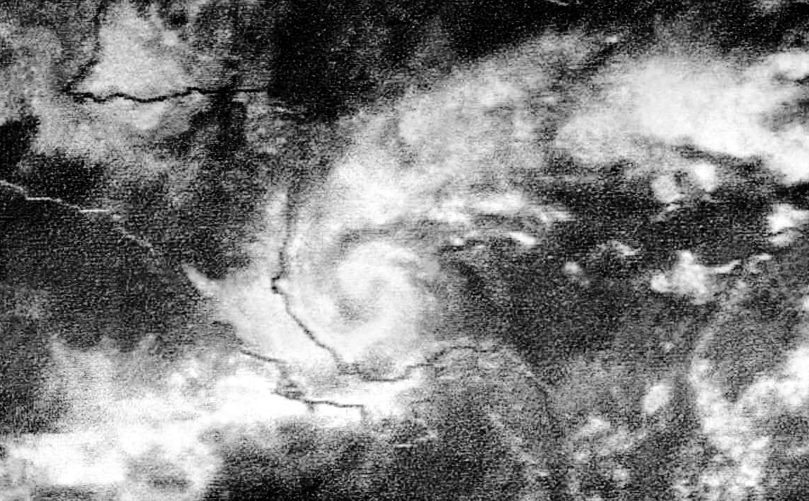
Like this one? "A RELATIVELY CLEAR AREA NEAR THE CENTER THAT RESEMBLES AN EYE".
That was from the initial discussion on what became Gustav, when it had an eye before it was named a TD.
0 likes
-
Evil Jeremy

- S2K Supporter
- Posts: 5459
- Age: 30
- Joined: Mon Apr 10, 2006 2:10 pm
- Location: Los Angeles, CA
Re: ATL : INVEST 97L
Should be code red in the TWO in about an hour.
0 likes
Frances 04 / Jeanne 04 / Katrina 05 / Wilma 05 / Fay 08 / Debby 12 / Andrea 13 / Colin 16 / Hermine 16 / Matthew 16 / Irma 17
-
MGC

- S2K Supporter
- Posts: 5792
- Joined: Sun Mar 23, 2003 9:05 pm
- Location: Pass Christian MS, or what is left.
Re: ATL : INVEST 97L
Just back from the Florida Keys. Had a wonderful time. Did any of ya'll see me at Fantasy Fest? I was a vampire...
Looks like a TD to me. Wish Recon was today as 97L looks to be organizing this morning......MGC
Looks like a TD to me. Wish Recon was today as 97L looks to be organizing this morning......MGC
0 likes
-
Evil Jeremy
- S2K Supporter
- Posts: 5459
- Age: 30
- Joined: Mon Apr 10, 2006 2:10 pm
- Location: Los Angeles, CA
-
cycloneye
- Admin
- Posts: 139083
- Age: 67
- Joined: Thu Oct 10, 2002 10:54 am
- Location: San Juan, Puerto Rico
Re: ATL : INVEST 97L - Models
12z CMC at 144 hours.Is with GFS on the placement of the system.

0 likes
Visit the Caribbean-Central America Weather Thread where you can find at first post web cams,radars
and observations from Caribbean basin members Click Here
and observations from Caribbean basin members Click Here
-
wxman57
- Moderator-Pro Met
- Posts: 22482
- Age: 66
- Joined: Sat Jun 21, 2003 8:06 pm
- Location: Houston, TX (southwest)
Re: ATL : INVEST 97L
12Z GFS continues along the line of the 00Z, taking it west and northwest and inland over Central America in a few days then dissipates it over the Yucatan this weekend. Probably a likely scenario. Wind shear should increase significantly north of 20N.
0 likes
-
cycloneye
- Admin
- Posts: 139083
- Age: 67
- Joined: Thu Oct 10, 2002 10:54 am
- Location: San Juan, Puerto Rico
Re: ATL : INVEST 97L - Models
First GFDL model plots,forecast to become a hurricane
A slow mover northbound.
WHXX04 KWBC 031723
CHGQLM
ATTENTION...NATIONAL HURRICANE CENTER
NCEP COUPLED GFDL HURRICANE MODEL FORECAST MADE FOR
TROPICAL DEPRESSION INVEST 97L
INITIAL TIME 12Z NOV 3
DISCLAIMER ... THIS INFORMATION IS PROVIDED AS GUIDANCE. IT
REQUIRES INTERPRETATION BY HURRICANE SPECIALISTS AND SHOULD
NOT BE CONSIDERED AS A FINAL PRODUCT. PLEASE SEE THE TPC/NHC
OFFICIAL FORECAST.
FORECAST STORM POSITION
HOUR LATITUDE LONGITUDE HEADING/SPEED(KT)
0 10.1 81.5 285./ 2.9
6 10.4 81.5 348./ 2.4
12 10.3 81.4 131./ 1.0
18 10.4 81.4 59./ .6
24 10.2 81.1 109./ 3.0
30 10.4 81.1 356./ 1.4
36 10.4 81.1 90./ .2
42 10.8 80.9 23./ 4.1
48 11.3 81.0 350./ 5.5
54 12.0 80.4 42./ 9.0
60 12.3 80.9 301./ 5.4
66 12.7 80.9 1./ 4.3
72 12.9 81.1 320./ 3.2
78 13.8 80.8 17./ 8.8
84 14.4 80.7 12./ 6.2
90 15.1 80.5 13./ 7.4
96 16.0 80.8 340./ 8.9
102 16.6 80.8 8./ 6.2
108 17.3 80.8 354./ 7.2
114 18.0 80.9 356./ 7.6
120 19.1 80.7 11./10.3
126 19.6 80.8 353./ 5.7
http://asp1.sbs.ohio-state.edu/tropical/guidance/
Animation of first GFDL run.
http://moe.met.fsu.edu/cgi-bin/gfdltc2. ... =Animation
0 likes
Visit the Caribbean-Central America Weather Thread where you can find at first post web cams,radars
and observations from Caribbean basin members Click Here
and observations from Caribbean basin members Click Here
-
wxman57
- Moderator-Pro Met
- Posts: 22482
- Age: 66
- Joined: Sat Jun 21, 2003 8:06 pm
- Location: Houston, TX (southwest)
Re: ATL : INVEST 97L - Models
Detailed GFDL model data here:
ftp://ftp.ncep.noaa.gov/pub/data/nccf/c ... tats.short
ftp://ftp.ncep.noaa.gov/pub/data/nccf/c ... tats.short
0 likes
-
Ad Novoxium
- Category 1

- Posts: 348
- Age: 33
- Joined: Sat May 03, 2008 2:12 am
Re: ATL : INVEST 97L
Is it just me, or is this looking really similar to 1969's Martha?
Image:
Track:

Admittedly, the likely track is not due south, but given where it is and how it looks, it does seem slightly eerie.
Image:
Track:
Admittedly, the likely track is not due south, but given where it is and how it looks, it does seem slightly eerie.
Last edited by Ad Novoxium on Tue Nov 03, 2009 12:43 pm, edited 1 time in total.
0 likes

-
ozonepete
- Professional-Met
- Posts: 4743
- Joined: Mon Sep 07, 2009 3:23 pm
- Location: From Ozone Park, NYC / Now in Brooklyn, NY
Re: ATL : INVEST 97L=Recon for Wednesday Afternoon at 20:00Z
HurricaneBelle wrote:tolakram wrote:This may require one of those infamous 'eye like feature' comments if it continues to organize.
Like this one? "A RELATIVELY CLEAR AREA NEAR THE CENTER THAT RESEMBLES AN EYE".
That was from the initial discussion on what became Gustav, when it had an eye before it was named a TD.
The key word is "RESEMBLES". That wasn't a true eye, but rather an "eye-like feature." Here's the NHC definition of an eye:
Eye:
The roughly circular area of comparatively light winds that encompasses the center of a severe tropical cyclone. The eye is either completely or partially surrounded by the eyewall cloud.
Since Gustav wasn't severe when a TD, they wouldn't call it an eye.
Here's the rest of it:
" AN SSM/IS IMAGE FROM SEVERAL HOURS AGO DEPICTED AN EYE-LIKE FEATURE AT THE 91 GHZ FREQUENCY... BUT IT WAS NOT EVIDENT ON THE 37 GHZ CHANNEL. SINCE THE LATTER CHANNEL IS MORE SENSITIVE TO THE LOWER-LEVELS...THIS EYE-LIKE FEATURE WAS PRIMARILY ALOFT. INTERESTINGLY HOWEVER...THE GEOSTATIONARY IMAGES ALSO SHOW A RELATIVELY CLEAR AREA NEAR THE CENTER THAT RESEMBLES AN EYE."
0 likes
-
gatorcane

- S2K Supporter
- Posts: 23499
- Age: 46
- Joined: Sun Mar 13, 2005 3:54 pm
- Location: Boca Raton, FL
I had a look at the satellite this morning. Expect code red from NHC in the next advisory folks.
Looks more like September out in the Caribbean then November doesn't it? Ironically when it was September it looked like November......
Looks more like September out in the Caribbean then November doesn't it? Ironically when it was September it looked like November......
Last edited by gatorcane on Tue Nov 03, 2009 12:51 pm, edited 9 times in total.
0 likes
Who is online
Users browsing this forum: No registered users and 117 guests