TIMOR SEA : TROPICAL CYCLONE LAURENCE (06S)

Moderator: S2k Moderators

Message
Author
User avatar
HURAKAN
Professional-Met
Professional-Met
Posts: 46086
Age: 37
Joined: Thu May 20, 2004 4:34 pm
Location: Key West, FL
Contact:

#141 Postby HURAKAN » Fri Dec 18, 2009 12:03 pm

Image

WTXS33 PGTW 181500
MSGID/GENADMIN/NAVMARFCSTCEN PEARL HARBOR HI/JTWC//
SUBJ/TROPICAL CYCLONE 06S (LAURENCE) WARNING NR 009//
RMKS/
1. TROPICAL CYCLONE 06S (LAURENCE) WARNING NR 009
01 ACTIVE TROPICAL CYCLONE IN SOUTHIO
MAX SUSTAINED WINDS BASED ON ONE-MINUTE AVERAGE
WIND RADII VALID OVER OPEN WATER ONLY
---
WARNING POSITION:
181200Z --- NEAR 17.2S 123.4E
MOVEMENT PAST SIX HOURS - 295 DEGREES AT 05 KTS
POSITION ACCURATE TO WITHIN 060 NM
POSITION BASED ON CENTER LOCATED BY A COMBINATION OF
SATELLITE, RADAR AND SYNOPTIC DATA
PRESENT WIND DISTRIBUTION:
MAX SUSTAINED WINDS - 035 KT, GUSTS 045 KT
WIND RADII VALID OVER OPEN WATER ONLY
REPEAT POSIT: 17.2S 123.4E
---
FORECASTS:
12 HRS, VALID AT:
190000Z --- 17.0S 122.4E
MAX SUSTAINED WINDS - 035 KT, GUSTS 045 KT
WIND RADII VALID OVER OPEN WATER ONLY
VECTOR TO 24 HR POSIT: 260 DEG/ 05 KTS
---
24 HRS, VALID AT:
191200Z --- 17.2S 121.4E
MAX SUSTAINED WINDS - 040 KT, GUSTS 050 KT
WIND RADII VALID OVER OPEN WATER ONLY
RADIUS OF 034 KT WINDS - 050 NM NORTHEAST QUADRANT
055 NM SOUTHEAST QUADRANT
055 NM SOUTHWEST QUADRANT
050 NM NORTHWEST QUADRANT
VECTOR TO 36 HR POSIT: 240 DEG/ 04 KTS
---
36 HRS, VALID AT:
200000Z --- 17.6S 120.7E
MAX SUSTAINED WINDS - 045 KT, GUSTS 055 KT
WIND RADII VALID OVER OPEN WATER ONLY
RADIUS OF 034 KT WINDS - 050 NM NORTHEAST QUADRANT
055 NM SOUTHEAST QUADRANT
055 NM SOUTHWEST QUADRANT
050 NM NORTHWEST QUADRANT
VECTOR TO 48 HR POSIT: 235 DEG/ 03 KTS
---
EXTENDED OUTLOOK:
48 HRS, VALID AT:
201200Z --- 18.0S 120.1E
MAX SUSTAINED WINDS - 055 KT, GUSTS 070 KT
WIND RADII VALID OVER OPEN WATER ONLY
RADIUS OF 050 KT WINDS - 025 NM NORTHEAST QUADRANT
025 NM SOUTHEAST QUADRANT
025 NM SOUTHWEST QUADRANT
025 NM NORTHWEST QUADRANT
RADIUS OF 034 KT WINDS - 055 NM NORTHEAST QUADRANT
060 NM SOUTHEAST QUADRANT
060 NM SOUTHWEST QUADRANT
055 NM NORTHWEST QUADRANT
VECTOR TO 72 HR POSIT: 210 DEG/ 02 KTS
---
72 HRS, VALID AT:
211200Z --- 18.8S 119.6E
MAX SUSTAINED WINDS - 065 KT, GUSTS 080 KT
WIND RADII VALID OVER OPEN WATER ONLY
RADIUS OF 050 KT WINDS - 030 NM NORTHEAST QUADRANT
030 NM SOUTHEAST QUADRANT
030 NM SOUTHWEST QUADRANT
030 NM NORTHWEST QUADRANT
RADIUS OF 034 KT WINDS - 060 NM NORTHEAST QUADRANT
065 NM SOUTHEAST QUADRANT
065 NM SOUTHWEST QUADRANT
060 NM NORTHWEST QUADRANT
VECTOR TO 96 HR POSIT: 185 DEG/ 02 KTS
---
LONG RANGE OUTLOOK:
NOTE...ERRORS FOR TRACK HAVE AVERAGED NEAR 250 NM
ON DAY 4 AND 350 NM ON DAY 5... AND FOR INTENSITY
NEAR 20 KT EACH DAY.
---
96 HRS, VALID AT:
221200Z --- 19.6S 119.5E
MAX SUSTAINED WINDS - 075 KT, GUSTS 090 KT
WIND RADII VALID OVER OPEN WATER ONLY
VECTOR TO 120 HR POSIT: 175 DEG/ 03 KTS
---
120 HRS, VALID AT:
231200Z --- 20.6S 119.6E
MAX SUSTAINED WINDS - 055 KT, GUSTS 070 KT
WIND RADII VALID OVER OPEN WATER ONLY
DISSIPATING AS A SIGNIFICANT TROPICAL CYCLONE OVER LAND
---
REMARKS:
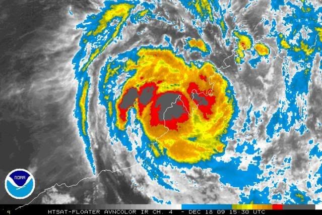
181500Z POSITION NEAR 17.1S 123.1E.
TROPICAL CYCLONE (TC) 06S (LAURENCE), LOCATED APPROXIMATELY 330 NM
NORTHEAST OF PORT HEDLAND, AUSTRALIA, HAS TRACKED WEST-NORTHWESTWARD
AT 05 KNOTS OVER THE PAST 06 HOURS. ANIMATED INFRARED SATELLITE
IMAGERY, RADAR IMAGERY FROM THE BROOME RADAR AND RECENT MICROWAVE
IMAGERY INDICATE THAT TC 06S HAS ACCELERATED WESTWARD AND
STRENGTHENED OVER THE PAST 12 HOURS. THE LATEST RADAR IMAGERY AT
18/13Z INDICATES THAT THE SYSTEM HAS JUST MOVED INLAND OVER
DAMPIER LAND AND ALSO DEPICTS A WELL-DEFINED LOW-LEVEL CIRCULATION
CENTER (LLCC) WITH CURVED CONVECTIVE BANDING SOUTH WRAPPING INTO THE
NORTHWEST QUADRANT. AN 18/1129Z SSMIS IMAGE REFLECTS THIS IMPROVED
CONSOLIDATION AND HINTS AT A WEAK, FORMATIVE MICROWAVE EYE. DESPITE
THE IMPROVED SIGNATURE IN MICROWAVE IMAGERY, NUMEROUS SURFACE
OBSERVATIONS IN THE AREA SUPPORT A 30-35 KNOT SYSTEM AT BEST. TC 06S
PASSED DIRECTLY OVER DERBY AT 18/09Z WITH A MINIMUM SLP OF 998 MB AND
SUSTAINED WINDS HAVE REMAINED NEAR 20 KNOTS WITH GUSTS TO 25 KNOTS.
ANIMATED WATER VAPOR IMAGERY SHOWS GOOD OVERALL OUTFLOW,
PARTICULARLY POLEWARD, WHICH IS ENHANCED BY AN UPPER-LEVEL TROUGH
OVER WESTERN AUSTRALIA. TC 06S IS FORECAST TO TRACK SLOWLY WESTWARD
UNDER THE STEERING INFLUENCE OF THE LOW- TO MID-LEVEL SUBTROPICAL
RIDGE (STR) OVER CENTRAL AUSTRALIA AND IS EXPECTED TO TURN SOUTHWARD
IN THE EXTENDED TAUS AS THE APPROACHING TROUGH ERODES THE WESTERN
PERIPHERY OF THE STR. THE NUMERICAL GUIDANCE IS IN GOOD AGREEMENT
WITH ONLY MINOR DIFFERENCES IN THE TIMING OF THE RE-CURVE. THE
SYSTEM IS EXPECTED TO INTENSIFY AT A 10-15 KNOT PER DAY RATE
ONCE IT MOVES BACK OVER WARM WATER BUT IT IS POSSIBLE THE SYSTEM
MAY INTENSIFY MORE RAPIDLY AND PEAK AT A MUCH HIGHER INTENSITY
UNDER THE FAVORABLE CONDITIONS. MAXIMUM SIGNIFICANT WAVE HEIGHT
AT 181200Z IS 8 FEET. NEXT WARNINGS AT 190300Z AND 191500Z.//
NNNN
0 likes   

User avatar
Crostorm
Category 5
Category 5
Posts: 2060
Age: 49
Joined: Mon Dec 25, 2006 3:51 pm
Location: Croatia-Europe
Contact:

#142 Postby Crostorm » Fri Dec 18, 2009 12:04 pm

What is wrong whit NRL :?:
NOTE: Data processing issues, working to catch up [12-18 15Z]
0 likes   

User avatar
HURAKAN
Professional-Met
Professional-Met
Posts: 46086
Age: 37
Joined: Thu May 20, 2004 4:34 pm
Location: Key West, FL
Contact:

#143 Postby HURAKAN » Fri Dec 18, 2009 12:06 pm

Image

Just onshore
0 likes   

User avatar
Chacor
Category 5
Category 5
Posts: 10229
Joined: Mon Oct 02, 2006 10:43 pm
Location: Singapore

#144 Postby Chacor » Fri Dec 18, 2009 12:21 pm

Looking really good in that last image.
0 likes   

User avatar
HURAKAN
Professional-Met
Professional-Met
Posts: 46086
Age: 37
Joined: Thu May 20, 2004 4:34 pm
Location: Key West, FL
Contact:

#145 Postby HURAKAN » Fri Dec 18, 2009 1:01 pm

Image

Latest
0 likes   

User avatar
Macrocane
Category 5
Category 5
Posts: 4218
Age: 35
Joined: Sun May 24, 2009 5:35 pm
Location: El Salvador

Re: TIMOR SEA : EX-TROPICAL CYCLONE LAURENCE (06S)

#146 Postby Macrocane » Fri Dec 18, 2009 1:28 pm

If it has intensified inland I can imagine what it is going to do in water, a rapid intensification seems likely.
0 likes   

User avatar
HURAKAN
Professional-Met
Professional-Met
Posts: 46086
Age: 37
Joined: Thu May 20, 2004 4:34 pm
Location: Key West, FL
Contact:

#147 Postby HURAKAN » Fri Dec 18, 2009 2:27 pm

Image

TROPICAL CYCLONE ADVICE NUMBER 61
Issued at 2:50 am WST on Saturday, 19 December 2009
BY THE BUREAU OF METEOROLOGY
TROPICAL CYCLONE WARNING CENTRE PERTH

A Cyclone WARNING continues for coastal areas from Cape Leveque to Bidyadanga.

A Cyclone WATCH continues for coastal areas from Bidyadanga to Pardoo.

At 2:00 am WST Ex-Tropical Cyclone Laurence was estimated to be
155 kilometres north northeast of Broome and moving
west northwest at 12 kilometres per hour.

Ex-Tropical Cyclone Laurence is moving over the Dampier Peninsula towards the
west Kimberley coast.

The low is expected to move off the west Kimberley coast this morning. It is
then likely to reintensify and GALES could develop along the west Kimberley
coast between Cape Leveque and Bidyadanga, including Broome, during Saturday. As
the system moves westwards GALES could extend further down the coast to Pardoo
late on Sunday.

Heavy rainfall is expected to continue in the west Kimberley with 24 hour falls
in excess of 200mm possible.


FESA-State Emergency Service advises that there are no community alerts at
present.
Communities in the western Kimberley and northern Pilbara should listen for the
next advice.


Details of Ex-Tropical Cyclone Laurence at 2:00 am WST:
.Centre located near...... 16.7 degrees South 122.8 degrees East
.Location accuracy........ within 35 kilometres
.Recent movement.......... towards the west northwest at 12 kilometres per hour
.Wind gusts near centre... 85 kilometres per hour
.Severity category........ below cyclone intensity
.Central pressure......... 998 hectoPascals

The next advice will be issued by 6:00 am WST Saturday 19 December. Cyclone
advices and State Emergency Service Community Alerts are available by
dialling 1300 659 210


A map showing the track of the cyclone is available at:
http://www.bom.gov.au/weather/cyclone
0 likes   

User avatar
HURAKAN
Professional-Met
Professional-Met
Posts: 46086
Age: 37
Joined: Thu May 20, 2004 4:34 pm
Location: Key West, FL
Contact:

#148 Postby HURAKAN » Fri Dec 18, 2009 2:28 pm

TROPICAL CYCLONE TECHNICAL BULLETIN: AUSTRALIA - WESTERN REGION
Issued by PERTH TROPICAL CYCLONE WARNING CENTRE
at: 1919 UTC 18/12/2009
Name: Ex-Tropical Cyclone Laurence
Identifier: 01U
Data At: 1800 UTC
Latitude: 16.7S
Longitude: 122.8E
Location Accuracy: within 20 nm [35 km]
Movement Towards: west northwest [298 deg]
Speed of Movement: 6 knots [12 km/h]
Maximum 10-Minute Wind: 30 knots [55 km/h]
Maximum 3-Second Wind Gust: 45 knots [85 km/h]
Central Pressure: 998 hPa
Radius of 34-knot winds NE quadrant:
Radius of 34-knot winds SE quadrant:
Radius of 34-knot winds SW quadrant:
Radius of 34-knot winds NW quadrant:
Radius of 48-knot winds NE quadrant:
Radius of 48-knot winds SE quadrant:
Radius of 48-knot winds SW quadrant:
Radius of 48-knot winds NW quadrant:
Radius of 64-knot winds:
Radius of Maximum Winds: N/A nm N/A km
Dvorak Intensity Code: N/A
Pressure of outermost isobar: 1004 hPa
Radius of outermost closed isobar: 60 nm [110 km]
Storm Depth: Medium
FORECAST DATA
Date/Time : Location : Loc. Accuracy: Max Wind : Central Pressure
[UTC] : degrees : nm [km]: knots[km/h]: hPa
+12: 19/0600: 16.6S 122.0E: 050 [095]: 035 [065]: 995
+24: 19/1800: 16.9S 121.3E: 070 [130]: 050 [095]: 986
+36: 20/0600: 17.5S 120.6E: 085 [155]: 055 [100]: 983
+48: 20/1800: 18.0S 120.3E: 100 [185]: 065 [120]: 973
+60: 21/0600: 18.6S 120.2E: 140 [260]: 080 [150]: 959
+72: 21/1800: 19.0S 120.2E: 180 [335]: 090 [165]: 950
REMARKS:
Ex-TC Laurence has begun to track steadily toward the west Kimberley coast. This
motion is likely to continue under the influence of low level flow until the
system moves off the west Kimberley coast. As it moves off the coast vertical
wind shear is expected to be light and with a well developed low to mid level
circulation and a moist profile through depth the system is expected to
redevelop rapidly once over open water. The system is likely to move offshore
Saturday morning. Once it redevelops it will experience a weak deep layer
steering pattern and motion will slow.

Rainfall totals near the centre have been over 200mm in the last 24 hours, with
isolated heavier falls. Most rain fell in the Leonard River catchment rather
than the Fitzroy River catchment.


Copyright Commonwealth of Australia
==
The next bulletin for this system will be issued by: 19/0100 UTC by Perth TCWC.
0 likes   

Sanibel
Category 5
Category 5
Posts: 10348
Joined: Mon Aug 30, 2004 11:06 pm
Location: Offshore SW Florida

Re: TIMOR SEA : EX-TROPICAL CYCLONE LAURENCE (06S)

#149 Postby Sanibel » Fri Dec 18, 2009 3:27 pm

Looks like a double landfaller.
0 likes   

User avatar
HURAKAN
Professional-Met
Professional-Met
Posts: 46086
Age: 37
Joined: Thu May 20, 2004 4:34 pm
Location: Key West, FL
Contact:

#150 Postby HURAKAN » Fri Dec 18, 2009 4:46 pm

Image

Latest
0 likes   

User avatar
HURAKAN
Professional-Met
Professional-Met
Posts: 46086
Age: 37
Joined: Thu May 20, 2004 4:34 pm
Location: Key West, FL
Contact:

#151 Postby HURAKAN » Fri Dec 18, 2009 5:09 pm

TROPICAL CYCLONE ADVICE NUMBER 62
Issued at 5:50 am WST on Saturday, 19 December 2009
BY THE BUREAU OF METEOROLOGY
TROPICAL CYCLONE WARNING CENTRE PERTH

A Cyclone WARNING continues for coastal areas from Cape Leveque to Bidyadanga.

A Cyclone WATCH continues for coastal areas from Bidyadanga to Pardoo.

At 5:00 am WST Ex-Tropical Cyclone Laurence was estimated to be
145 kilometres north northeast of Broome and moving
west northwest at 12 kilometres per hour.

Ex-Tropical Cyclone Laurence has moved over the Dampier Peninsula and crossed
the west Kimberley coast.

The low is expected to reintensify into a tropical cyclone in the next three to
six hours. GALES could develop along the west Kimberley coast between Cape
Leveque and Bidyadanga, including Broome during the morning. As the system moves
south westwards GALES could extend further down the coast to Pardoo late on
Sunday.

Heavy rainfall is expected to continue in the west Kimberley with 24 hour falls
in excess of 200mm possible. Curtin has reported 142mm since 9am Friday.


FESA-State Emergency Service advises as a precautionary measure the following
community alerts:
BLUE ALERT: People in the communities from Cape Leveque to Beagle Bay, including
One Arm Point, Djarindjin and Lombadina need to prepare for cyclonic weather and
organise an emergency kit including first aid kit, torch, portable radio, spare
batteries, food and water.
Communities in the remainder of the western Kimberley and northern Pilbara
should listen for the next advice.


Details of Ex-Tropical Cyclone Laurence at 5:00 am WST:
.Centre located near...... 16.7 degrees South 122.5 degrees East
.Location accuracy........ within 35 kilometres
.Recent movement.......... towards the west northwest at 12 kilometres per hour
.Wind gusts near centre... 85 kilometres per hour
.Severity category........ below cyclone intensity
.Central pressure......... 996 hectoPascals

The next advice will be issued by 9:00 am WST Saturday 19 December.Cyclone
advices and State Emergency Service Community Alerts are available by
dialling 1300 659 210

A map showing the track of the cyclone is available at:
http://www.bom.gov.au/weather/cyclone


Image
0 likes   

User avatar
HURAKAN
Professional-Met
Professional-Met
Posts: 46086
Age: 37
Joined: Thu May 20, 2004 4:34 pm
Location: Key West, FL
Contact:

#152 Postby HURAKAN » Fri Dec 18, 2009 7:55 pm

TROPICAL CYCLONE ADVICE NUMBER 63
Issued at 8:50 am WST on Saturday, 19 December 2009
BY THE BUREAU OF METEOROLOGY
TROPICAL CYCLONE WARNING CENTRE PERTH

A Cyclone WARNING continues for coastal areas from Cape Leveque to Bidyadanga.

A Cyclone WATCH continues for coastal areas from Bidyadanga to De Grey.

At 8:00 am WST Ex-Tropical Cyclone Laurence was estimated to be
145 kilometres north of Broome and moving
west northwest at 10 kilometres per hour.

Ex-Tropical Cyclone Laurence has moved off the west Kimberley coast and is
expected to reintensify into a tropical cyclone in the next three to six hours.

GALES could develop along the west Kimberley coast between Cape Leveque and
Beagle Bay this morning and may extend further down the coast to Broome and
Bidyadanga later today or early on Sunday. As the system moves south westwards
GALES could extend further down the coast to De Grey by Monday morning. The
system is expected to take a more southerly track on Monday and is likely to
cross the east Pilbara coast near Eighty Mile Beach.

Heavy rainfall is expected to continue today in coastal parts of the west
Kimberley with 24 hour falls in excess of 100mm possible.

FESA-State Emergency Service advises as a precautionary measure the following
community alerts:
BLUE ALERT: People in the communities from Cape Leveque to Bidyadanga, including
Broome, Beagle Bay, One Arm Point, Djarindjin and Lombadina need to prepare for
a period of cyclonic weather.
Communities in northern Pilbara should listen for the next advice.


Details of Ex-Tropical Cyclone Laurence at 8:00 am WST:
.Centre located near...... 16.7 degrees South 122.4 degrees East
.Location accuracy........ within 35 kilometres
.Recent movement.......... towards the west northwest at 10 kilometres per hour
.Wind gusts near centre... 85 kilometres per hour
.Severity category........ below cyclone intensity
.Central pressure......... 998 hectoPascals

The next advice will be issued by midday WST Saturday 19 December.Cyclone
advices and State Emergency Service Community Alerts are available by
dialling 1300 659 210


A map showing the track of the cyclone is available at:
http://www.bom.gov.au/weather/cyclone
0 likes   

User avatar
HURAKAN
Professional-Met
Professional-Met
Posts: 46086
Age: 37
Joined: Thu May 20, 2004 4:34 pm
Location: Key West, FL
Contact:

#153 Postby HURAKAN » Fri Dec 18, 2009 7:56 pm

Image

Latest
0 likes   

User avatar
HURAKAN
Professional-Met
Professional-Met
Posts: 46086
Age: 37
Joined: Thu May 20, 2004 4:34 pm
Location: Key West, FL
Contact:

#154 Postby HURAKAN » Fri Dec 18, 2009 10:13 pm

18/2030 UTC 16.7S 122.7E T2.5/2.5 LAURENCE -- Southeast Indian

35 knots
0 likes   

User avatar
HURAKAN
Professional-Met
Professional-Met
Posts: 46086
Age: 37
Joined: Thu May 20, 2004 4:34 pm
Location: Key West, FL
Contact:

#155 Postby HURAKAN » Fri Dec 18, 2009 10:14 pm

Image

WTXS33 PGTW 190300
MSGID/GENADMIN/NAVMARFCSTCEN PEARL HARBOR HI/JTWC//
SUBJ/TROPICAL CYCLONE 06S (LAURENCE) WARNING NR 010//
RMKS/
1. TROPICAL CYCLONE 06S (LAURENCE) WARNING NR 010
01 ACTIVE TROPICAL CYCLONE IN SOUTHIO
MAX SUSTAINED WINDS BASED ON ONE-MINUTE AVERAGE
WIND RADII VALID OVER OPEN WATER ONLY
---
WARNING POSITION:
190000Z --- NEAR 16.7S 122.4E
MOVEMENT PAST SIX HOURS - 285 DEGREES AT 04 KTS
POSITION ACCURATE TO WITHIN 060 NM
POSITION BASED ON CENTER LOCATED BY A COMBINATION OF
SATELLITE AND RADAR
PRESENT WIND DISTRIBUTION:
MAX SUSTAINED WINDS - 035 KT, GUSTS 045 KT
WIND RADII VALID OVER OPEN WATER ONLY
REPEAT POSIT: 16.7S 122.4E
---
FORECASTS:
12 HRS, VALID AT:
191200Z --- 16.7S 121.5E
MAX SUSTAINED WINDS - 040 KT, GUSTS 050 KT
WIND RADII VALID OVER OPEN WATER ONLY
RADIUS OF 034 KT WINDS - 015 NM NORTHEAST QUADRANT
015 NM SOUTHEAST QUADRANT
015 NM SOUTHWEST QUADRANT
015 NM NORTHWEST QUADRANT
VECTOR TO 24 HR POSIT: 245 DEG/ 04 KTS
---
24 HRS, VALID AT:
200000Z --- 17.0S 120.8E
MAX SUSTAINED WINDS - 045 KT, GUSTS 055 KT
WIND RADII VALID OVER OPEN WATER ONLY
RADIUS OF 034 KT WINDS - 025 NM NORTHEAST QUADRANT
030 NM SOUTHEAST QUADRANT
030 NM SOUTHWEST QUADRANT
020 NM NORTHWEST QUADRANT
VECTOR TO 36 HR POSIT: 215 DEG/ 03 KTS
---
36 HRS, VALID AT:
201200Z --- 17.5S 120.4E
MAX SUSTAINED WINDS - 055 KT, GUSTS 070 KT
WIND RADII VALID OVER OPEN WATER ONLY
RADIUS OF 050 KT WINDS - 020 NM NORTHEAST QUADRANT
020 NM SOUTHEAST QUADRANT
020 NM SOUTHWEST QUADRANT
020 NM NORTHWEST QUADRANT
RADIUS OF 034 KT WINDS - 035 NM NORTHEAST QUADRANT
045 NM SOUTHEAST QUADRANT
040 NM SOUTHWEST QUADRANT
030 NM NORTHWEST QUADRANT
VECTOR TO 48 HR POSIT: 205 DEG/ 03 KTS
---
EXTENDED OUTLOOK:
48 HRS, VALID AT:
210000Z --- 18.1S 120.1E
MAX SUSTAINED WINDS - 060 KT, GUSTS 075 KT
WIND RADII VALID OVER OPEN WATER ONLY
RADIUS OF 050 KT WINDS - 020 NM NORTHEAST QUADRANT
020 NM SOUTHEAST QUADRANT
020 NM SOUTHWEST QUADRANT
020 NM NORTHWEST QUADRANT
RADIUS OF 034 KT WINDS - 040 NM NORTHEAST QUADRANT
035 NM SOUTHEAST QUADRANT
035 NM SOUTHWEST QUADRANT
040 NM NORTHWEST QUADRANT
VECTOR TO 72 HR POSIT: 190 DEG/ 03 KTS
---
72 HRS, VALID AT:
220000Z --- 19.2S 119.9E
MAX SUSTAINED WINDS - 065 KT, GUSTS 080 KT
WIND RADII VALID OVER OPEN WATER ONLY
RADIUS OF 050 KT WINDS - 025 NM NORTHEAST QUADRANT
025 NM SOUTHEAST QUADRANT
025 NM SOUTHWEST QUADRANT
025 NM NORTHWEST QUADRANT
RADIUS OF 034 KT WINDS - 035 NM NORTHEAST QUADRANT
045 NM SOUTHEAST QUADRANT
040 NM SOUTHWEST QUADRANT
030 NM NORTHWEST QUADRANT
VECTOR TO 96 HR POSIT: 175 DEG/ 03 KTS
---
LONG RANGE OUTLOOK:
NOTE...ERRORS FOR TRACK HAVE AVERAGED NEAR 250 NM
ON DAY 4 AND 350 NM ON DAY 5... AND FOR INTENSITY
NEAR 20 KT EACH DAY.
---
96 HRS, VALID AT:
230000Z --- 20.3S 120.0E
MAX SUSTAINED WINDS - 055 KT, GUSTS 070 KT
WIND RADII VALID OVER OPEN WATER ONLY
DISSIPATING AS A SIGNIFICANT TROPICAL CYCLONE OVER LAND
VECTOR TO 120 HR POSIT: 150 DEG/ 04 KTS
---
120 HRS, VALID AT:
240000Z --- 21.6S 120.8E
MAX SUSTAINED WINDS - 030 KT, GUSTS 040 KT
WIND RADII VALID OVER OPEN WATER ONLY
DISSIPATED AS A SIGNIFICANT TROPICAL CYCLONE OVER LAND
---
REMARKS:
190300Z POSITION NEAR 16.7S 122.2E.
TROPICAL CYCLONE (TC) 06S (LAURENCE), LOCATED APPROXIMATELY 300 NM
NORTHEAST OF PORT HEDLAND, AUSTRALIA, HAS TRACKED WEST-NORTHWESTWARD
AT 04 KNOTS OVER THE PAST SIX HOURS. TC 06S HAS RECENTLY MOVED BACK
OVER WATER AND IS EXPECTED TO RE-INTENSIFY OVER THE NEXT 72 HOURS.
THE POSITION OVER WATER IS SUPPORTED BY RADAR IMAGERY FROM BROOME,
AUSTRALIA, WHICH ALSO SHOWS THE CURVED CONVECTIVE BANDING WRAPPING
AROUND A LOW LEVEL CIRCULATION CENTER. THE CURRENT INTENSITY OF 35
KNOTS IS SUPPORTED BY A PGTW DVORAK ESTIMATE OF T2.5 AND NEARBY
SURFACE OBSERVATIONS. UPPER LEVEL ANALYSIS CONTINUES TO INDICATE A
FAVORABLE ENVIRONMENT FOR DEVELOPMENT INCLUDING MODERATE WIND SHEAR
AND BOTH GOOD POLEWARD AND EQUATORWARD OUTFLOW. THE SYSTEM IS
CURRENTLY BEING STEERED BY THE SUBTROPICAL RIDGE TO THE SOUTHEAST.
AN APPROACHING MID-LATITUDE TROUGH FROM THE WEST WILL CAUSE THE
SYSTEM TO TURN TO THE SOUTH AFTER TAU 36 THEN TO THE SOUTHEAST AFTER
IT MAKES LANDFALL BY TAU 96. ONCE 06S REACHES LAND, IT WILL BEGIN TO
WEAKEN AND EVENTUALLY DISSIPATE BY TAU 120. THIS FORECAST TRACK IS
IN GENERAL AGREEMENT WITH MODEL GUIDANCE. MAXIMUM SIGNIFICANT WAVE
HEIGHT AT 190000Z IS 6 FEET. NEXT WARNINGS AT 191500Z AND 200300Z.//
NNNN
0 likes   

User avatar
HURAKAN
Professional-Met
Professional-Met
Posts: 46086
Age: 37
Joined: Thu May 20, 2004 4:34 pm
Location: Key West, FL
Contact:

#156 Postby HURAKAN » Fri Dec 18, 2009 10:15 pm

Image

Latest
0 likes   

User avatar
HURAKAN
Professional-Met
Professional-Met
Posts: 46086
Age: 37
Joined: Thu May 20, 2004 4:34 pm
Location: Key West, FL
Contact:

#157 Postby HURAKAN » Fri Dec 18, 2009 10:18 pm

Image

Latest
0 likes   

CrazyC83
Professional-Met
Professional-Met
Posts: 33393
Joined: Tue Mar 07, 2006 11:57 pm
Location: Deep South, for the first time!

#158 Postby CrazyC83 » Fri Dec 18, 2009 11:05 pm

The center seems to be hugging the islands, yet it still intensified...

Looks to be about 45 kt right now, pressure around 992mb.
0 likes   

User avatar
HURAKAN
Professional-Met
Professional-Met
Posts: 46086
Age: 37
Joined: Thu May 20, 2004 4:34 pm
Location: Key West, FL
Contact:

#159 Postby HURAKAN » Fri Dec 18, 2009 11:20 pm

TROPICAL CYCLONE ADVICE NUMBER 64
Issued at 11:55 am WST on Saturday, 19 December 2009
BY THE BUREAU OF METEOROLOGY
TROPICAL CYCLONE WARNING CENTRE PERTH

A Cyclone WARNING continues for coastal areas from Cape Leveque to Bidyadanga.

A Cyclone WATCH continues for coastal areas from Bidyadanga to De Grey.

At 11:00 am WST Tropical Cyclone Laurence was estimated to be
140 kilometres north of Broome and moving
west northwest at 8 kilometres per hour.

Tropical Cyclone Laurence has rapidly redeveloped after moving off the west
Kimberley coast.

GALES are occurring at offshore islands and may develop along the coast between
Cape Leveque and Beagle Bay this afternoon as the system continues to intensify.
GALES may extend further down the coast to Broome and Bidyadanga later today or
early on Sunday. As the system moves south westwards GALES could extend further
down the coast to De Grey by Monday morning. The system is expected to take a
more southerly track on Monday and then south eastwards towards the north
Pilbara coast on Tuesday.

Heavy rainfall is expected to continue today in coastal parts of the west
Kimberley with 24 hour falls in excess of 100mm possible.

FESA-State Emergency Service advises as a precautionary measure the following
community alerts:
BLUE ALERT: People in the communities from Cape Leveque to Bidyadanga, including
Broome, Beagle Bay, One Arm Point, Djarindjin and Lombadina need to prepare for
cyclonic weather and organise an emergency kit including first aid kit, torch,
portable radio, spare batteries, food and water.
Communities in northern Pilbara should listen for the next advice.


Details of Tropical Cyclone Laurence at 11:00 am WST:
.Centre located near...... 16.7 degrees South 122.3 degrees East
.Location accuracy........ within 20 kilometres
.Recent movement.......... towards the west northwest at 8 kilometres per hour
.Wind gusts near centre... 100 kilometres per hour
.Severity category........ 1
.Central pressure......... 990 hectoPascals

The next advice will be issued by 3:00 pm WST Saturday 19 December.Cyclone
advices and State Emergency Service Community Alerts are available by
dialling 1300 659 210


A map showing the track of the cyclone is available at:
http://www.bom.gov.au/weather/cyclone


Image
0 likes   

User avatar
HURAKAN
Professional-Met
Professional-Met
Posts: 46086
Age: 37
Joined: Thu May 20, 2004 4:34 pm
Location: Key West, FL
Contact:

#160 Postby HURAKAN » Fri Dec 18, 2009 11:31 pm

TROPICAL CYCLONE TECHNICAL BULLETIN: AUSTRALIA - WESTERN REGION
Issued by PERTH TROPICAL CYCLONE WARNING CENTRE
at: 0110 UTC 19/12/2009
Name: Ex-Tropical Cyclone Laurence
Identifier: 01U
Data At: 0000 UTC
Latitude: 16.7S
Longitude: 122.4E
Location Accuracy: within 20 nm [35 km]
Movement Towards: west northwest [291 deg]
Speed of Movement: 6 knots [10 km/h]
Maximum 10-Minute Wind: 30 knots [55 km/h]
Maximum 3-Second Wind Gust: 45 knots [85 km/h]
Central Pressure: 998 hPa
Radius of 34-knot winds NE quadrant:
Radius of 34-knot winds SE quadrant:
Radius of 34-knot winds SW quadrant:
Radius of 34-knot winds NW quadrant:
Radius of 48-knot winds NE quadrant:
Radius of 48-knot winds SE quadrant:
Radius of 48-knot winds SW quadrant:
Radius of 48-knot winds NW quadrant:
Radius of 64-knot winds:
Radius of Maximum Winds: N/A nm N/A km
Dvorak Intensity Code: N/A
Pressure of outermost isobar: 1004 hPa
Radius of outermost closed isobar: 70 nm [130 km]
Storm Depth: Deep
FORECAST DATA
Date/Time : Location : Loc. Accuracy: Max Wind : Central Pressure
[UTC] : degrees : nm [km]: knots[km/h]: hPa
+12: 19/1200: 16.9S 121.6E: 050 [095]: 050 [095]: 987
+24: 20/0000: 17.3S 120.6E: 080 [150]: 060 [110]: 980
+36: 20/1200: 17.8S 120.2E: 100 [185]: 060 [110]: 979
+48: 21/0000: 18.1S 120.0E: 120 [220]: 075 [140]: 964
+60: 21/1200: 18.6S 120.0E: 160 [295]: 085 [155]: 955
+72: 22/0000: 19.0S 120.2E: 200 [370]: 095 [175]: 945
REMARKS:
Ex-TC Laurence has moved off the west Kimberley coast north of Broome. The
circulation has excellent structure through some depth, a moist profile is
already established, vertical shear is low and oceanic heat content is high so
the system is expected to rapidly reintensify. Near gales have been reported
from an island off the coast just after the system went off shore.

Once it redevelops it will experience a weak deep layer steering pattern, motion
will slow and become more southerly. In the longer term the system is expected
to be caught up on upper westerly flow with a short wave feature that comes
through on Tuesday.

Copyright Commonwealth of Australia
==
The next bulletin for this system will be issued by: 19/0700 UTC by Perth TCWC.
0 likes   


Return to “2009”

Who is online

Users browsing this forum: No registered users and 38 guests