ATL: Ex INVEST 93L - Discussion
Moderator: S2k Moderators

-
Ivanhater

- Storm2k Moderator

- Posts: 10853
- Age: 37
- Joined: Fri Jul 01, 2005 8:25 am
- Location: Pensacola
Re: ATL: INVEST 93L - Discussion
Brent wrote:This has its chance. I think it's done.
Models love it


0 likes
Michael
TWD sings a less rosy tune than the TWO, mentioning increasing shear in 93L's future.
000
AXNT20 KNHC 100557
TWDAT
TROPICAL WEATHER DISCUSSION
NWS TPC/NATIONAL HURRICANE CENTER MIAMI FL
205 AM EDT TUE AUG 10 2010
TROPICAL WEATHER DISCUSSION FOR NORTH AMERICA...CENTRAL
AMERICA...GULF OF MEXICO...CARIBBEAN SEA...NORTHERN SECTIONS OF
SOUTH AMERICA...AND ATLANTIC OCEAN TO THE AFRICAN COAST FROM THE
EQUATOR TO 32N. THE FOLLOWING INFORMATION IS BASED ON SATELLITE
IMAGERY...METEOROLOGICAL ANALYSIS...WEATHER OBSERVATIONS...AND
RADAR.
BASED ON 0000 UTC SURFACE ANALYSIS AND SATELLITE IMAGERY THROUGH
0515 UTC.
...SPECIAL FEATURES...
AN AREA OF LOW PRESSURE IN THE CENTRAL ATLC IS ANALYZED AS A
1014 MB LOW NEAR 24N50W MOVING W-NW NEAR 10-15 KT AND IS
FORECAST TO TURN NW AND N DURING THE NEXT COUPLE OF DAYS DUE TO
AN UPPER LEVEL LOW CENTERED NEAR 26N60W. EARLIER ASCAT PASSES
INDICATED A STRONG WIND FIELD LOCATED WITHIN 240 NM OF THE
CENTER OF THE LOW IN THE NORTHERN SEMICIRCLE. SCATTERED SHOWERS
AND LIMITED ISOLATED MODERATE TO STRONG CONVECTION ARE NE OF THE
LOW FROM 20N-27N BETWEEN 45W-51W. ENVIRONMENTAL CONDITIONS ARE
MARGINALLY CONDUCIVE FOR DEVELOPMENT DUE TO A LACK OF UPPER
LEVEL WIND SHEAR...HOWEVER AS THE LOW TRACKS NW...IT WILL BEGIN
TO MOVE INTO AN AREA OF INCREASED WIND SHEAR AND LIKELY THWART
DEVELOPMENT. CURRENTLY SURROUNDED BY A FAVORABLE AREA OF UPPER
LEVEL DIVERGENCE...ORGANIZATION OF CONVECTION AND OVERALL
IMPROVEMENT OF SATELLITE PRESENCE COULD RESULT IN THE FORMATION
OF A TROPICAL CYCLONE OVER THE NEXT COUPLE OF DAYS.
<snip>
0 likes
6Z position update from ATCF shows continued W motion, steady at 30kt:
AL, 93, 2010081006, , BEST, 0, 236N, 512W, 30, 1012, LO, 34, NEQ, 0, 0, 0, 0, 1016, 150, 90, 0, 0, L, 0, , 0, 0, INVEST, S,
AL, 93, 2010081000, , BEST, 0, 236N, 502W, 30, 1012, LO, 0, , 0, 0, 0, 0, 1016, 125, 100, 0, 0, L, 0, , 0, 0, INVEST, S,
AL, 93, 2010081006, , BEST, 0, 236N, 512W, 30, 1012, LO, 34, NEQ, 0, 0, 0, 0, 1016, 150, 90, 0, 0, L, 0, , 0, 0, INVEST, S,
AL, 93, 2010081000, , BEST, 0, 236N, 502W, 30, 1012, LO, 0, , 0, 0, 0, 0, 1016, 125, 100, 0, 0, L, 0, , 0, 0, INVEST, S,
0 likes
-
Weatherfreak000

Hmmm I wouldn't call it a major burst but its certainly something that may help to give this system a much needed boost.
0 likes
Personal Forecast Disclaimer:
The posts in this forum are NOT official forecast and should not be used as such. They are just the opinion of the poster and may or may not be backed by sound meteorological data. They are NOT endorsed by any professional institution or storm2k.org. For official information, please refer to the NHC and NWS products
The posts in this forum are NOT official forecast and should not be used as such. They are just the opinion of the poster and may or may not be backed by sound meteorological data. They are NOT endorsed by any professional institution or storm2k.org. For official information, please refer to the NHC and NWS products
-
cycloneye

- Admin

- Posts: 139507
- Age: 67
- Joined: Thu Oct 10, 2002 10:54 am
- Location: San Juan, Puerto Rico
Re: ATL: INVEST 93L - Discussion
Still red but down to 60% at 8 AM TWO.
SATELLITE IMAGES INDICATE THAT THE SHOWER AND THUNDERSTORM ACTIVITY
ASSOCIATED WITH A LOW PRESSURE SYSTEM LOCATED ABOUT 820 MILES
EAST-NORTHEAST OF THE LEEWARDS ISLANDS HAS NOT BECOME ANY BETTER
ORGANIZED SINCE YESTERDAY. THE LOW HAS SLOWED DOWN AND IS EXPECTED
TO MOVE NORTH-NORTHWESTWARD OR NORTHWARD TOWARD AN ENVIRONMENT A
LITTLE LESS FAVORABLE FOR DEVELOPMENT. HOWEVER... THERE IS STILL A
HIGH CHANCE...60 PERCENT...OF THIS SYSTEM BECOMING A TROPICAL
CYCLONE DURING THE NEXT 48 HOURS.
0 likes
Visit the Caribbean-Central America Weather Thread where you can find at first post web cams,radars
and observations from Caribbean basin members Click Here
and observations from Caribbean basin members Click Here
Down to 60% which makes sense given the fact it still isn't producing the goods so to speak!
I still don't think we can rule out development though as it starts to curve NNE/NE.
I still don't think we can rule out development though as it starts to curve NNE/NE.
0 likes
Personal Forecast Disclaimer:
The posts in this forum are NOT official forecast and should not be used as such. They are just the opinion of the poster and may or may not be backed by sound meteorological data. They are NOT endorsed by any professional institution or storm2k.org. For official information, please refer to the NHC and NWS products
The posts in this forum are NOT official forecast and should not be used as such. They are just the opinion of the poster and may or may not be backed by sound meteorological data. They are NOT endorsed by any professional institution or storm2k.org. For official information, please refer to the NHC and NWS products
What will be interesting to watch for is when the system starts to turn northwards, I've noticed systems with this sort of sheared looking presentation often get better organised when they move northwards.
0 likes
Personal Forecast Disclaimer:
The posts in this forum are NOT official forecast and should not be used as such. They are just the opinion of the poster and may or may not be backed by sound meteorological data. They are NOT endorsed by any professional institution or storm2k.org. For official information, please refer to the NHC and NWS products
The posts in this forum are NOT official forecast and should not be used as such. They are just the opinion of the poster and may or may not be backed by sound meteorological data. They are NOT endorsed by any professional institution or storm2k.org. For official information, please refer to the NHC and NWS products
-
Aquawind

- Category 5

- Posts: 6714
- Age: 60
- Joined: Mon Jun 16, 2003 10:41 pm
- Location: Salisbury, NC
- Contact:
Re:
KWT wrote:What will be interesting to watch for is when the system starts to turn northwards, I've noticed systems with this sort of sheared looking presentation often get better organised when they move northwards.
Exactly..Go with the flow and grow.
0 likes
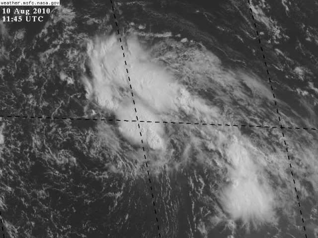
Whilst I've not looked at the loop yet, that still image that Hurakan has pu up sure makes it look like it has a multiple low look to it, with two LLCs?
0 likes
Personal Forecast Disclaimer:
The posts in this forum are NOT official forecast and should not be used as such. They are just the opinion of the poster and may or may not be backed by sound meteorological data. They are NOT endorsed by any professional institution or storm2k.org. For official information, please refer to the NHC and NWS products
The posts in this forum are NOT official forecast and should not be used as such. They are just the opinion of the poster and may or may not be backed by sound meteorological data. They are NOT endorsed by any professional institution or storm2k.org. For official information, please refer to the NHC and NWS products
-
HURAKAN

- Professional-Met

- Posts: 46086
- Age: 37
- Joined: Thu May 20, 2004 4:34 pm
- Location: Key West, FL
- Contact:
Re:
KWT wrote:Whilst I've not looked at the loop yet, that still image that Hurakan has pu up sure makes it look like it has a multiple low look to it, with two LLCs?

small vortex going around the well-defined center
0 likes
-
HURAKAN
- Professional-Met
- Posts: 46086
- Age: 37
- Joined: Thu May 20, 2004 4:34 pm
- Location: Key West, FL
- Contact:
Loop - http://rammb.cira.colostate.edu/ramsdis ... is_floater
Convection is forming very close to the center ... if it persists, we have a cyclone, if not, then no cyclone.
Convection is forming very close to the center ... if it persists, we have a cyclone, if not, then no cyclone.
0 likes
-
Aquawind
- Category 5
- Posts: 6714
- Age: 60
- Joined: Mon Jun 16, 2003 10:41 pm
- Location: Salisbury, NC
- Contact:
Re:
HURAKAN wrote:Loop - http://rammb.cira.colostate.edu/ramsdis ... is_floater
Convection is forming very close to the center ... if it persists, we have a cyclone, if not, then no cyclone.
Yep it's missing that very important part of the puzzle.. Persistant convection..for a few days now.
0 likes
Who is online
Users browsing this forum: No registered users and 2 guests