SATL: INVEST 90Q ("ANITA")
Moderator: S2k Moderators
- cycloneye
- Admin
- Posts: 139069
- Age: 67
- Joined: Thu Oct 10, 2002 10:54 am
- Location: San Juan, Puerto Rico
Re: SOUTHERN ATLANTIC - INVEST 90Q
SL, 90, 2010031000, , BEST, 0, 298S, 482W, 35, 1003, LO
ftp://ftp.tpc.ncep.noaa.gov/atcf/tcweb/ ... 010.invest
0 likes
Visit the Caribbean-Central America Weather Thread where you can find at first post web cams,radars
and observations from Caribbean basin members Click Here
Re: SOUTHERN ATLANTIC - INVEST 90Q
Numbers go up:
09/2345 UTC 29.8S 48.1W ST2.5 INVEST -- South Atlantic
0 likes
Re:
RL3AO wrote:Upgrade to what? Theres no one to upgrade it. HPC is calling it a subtropical cyclone. Thats probably about as much as we will get unless I'm missing something.
Upgrade to tropical, if convection increses near the center it could be upgraded to a tropical cyclone.
0 likes
-
- Tropical Storm
- Posts: 103
- Joined: Wed Dec 06, 2006 9:08 pm
- Location: São Leopoldo, Brazil
- P.K.
- Professional-Met
- Posts: 5149
- Joined: Thu Sep 23, 2004 5:57 pm
- Location: Watford, England
- Contact:
Re: Re:
Macrocane wrote:RL3AO wrote:Upgrade to what? Theres no one to upgrade it. HPC is calling it a subtropical cyclone. Thats probably about as much as we will get unless I'm missing something.
Upgrade to tropical, if convection increses near the center it could be upgraded to a tropical cyclone.
Brazil don't issue specific TC advisories so there will be no upgrade. They do have a warning out for rough seas in this area though.
WWST02 SBBR 100300
1 31 05 02 12 20
WARNING NR 086/2010
ROUGH/VERY ROUGH SEA WARNING
ISSUED AT 1500 GMT - MON - 08/MAR/2010
AREA BRAVO STARTING AT 090000 GMT. WAVES FM E/SE 3.0/4.5 METERS.
VALID UNTIL 101200 GMT.
WARNING NR 087/2010
ROUGH/VERY ROUGH SEA WARNING
ISSUED AT 1500 GMT - MON - 08/MAR/2010
AREA ALFA. WAVES FM NE/SE 3.0/5.0 METERS.
VALID UNTIL 110000GMT.
THIS MESSAGE CANCELS AND REPLACES THE WARNING NR 082/2010
WARNING NR 088/2010
HIGH SURF WARNING
ISSUED AT 15000 GMT - MON- 08/MAR/2010
AREAS ALFA AND CHARLIE AT S OF 26S STARTING AT 090000GMT. WAVES FROM E/SE 2.5/3.0 METERS.
VALID UNTIL 101200GMT.
NNNN
0 likes
- TheEuropean
- Professional-Met
- Posts: 1793
- Age: 58
- Joined: Tue Sep 20, 2005 3:17 pm
- Location: Voerde, Germany
- Contact:
Hmmm seems like had this been in another basin it quite probably would have been upgraded by now, convection looks good enough IMO and is comprable to the systems we get in the far NE of the Atlantic basin.
0 likes
Personal Forecast Disclaimer:
The posts in this forum are NOT official forecast and should not be used as such. They are just the opinion of the poster and may or may not be backed by sound meteorological data. They are NOT endorsed by any professional institution or storm2k.org. For official information, please refer to the NHC and NWS products
- littlevince
- S2K Supporter
- Posts: 768
- Joined: Fri Oct 21, 2005 10:45 am
- Location: Portugal
- cycloneye
- Admin
- Posts: 139069
- Age: 67
- Joined: Thu Oct 10, 2002 10:54 am
- Location: San Juan, Puerto Rico
Re: SOUTHERN ATLANTIC - INVEST 90Q
SL, 90, 2010031012, , BEST, 0, 297S, 476W, 40, 1000, LO
ftp://ftp.tpc.ncep.noaa.gov/atcf/tcweb/ ... 010.invest
0 likes
Visit the Caribbean-Central America Weather Thread where you can find at first post web cams,radars
and observations from Caribbean basin members Click Here
- cycloneye
- Admin
- Posts: 139069
- Age: 67
- Joined: Thu Oct 10, 2002 10:54 am
- Location: San Juan, Puerto Rico
Re: SOUTHERN ATLANTIC - INVEST 90Q
Dr Jeff Masters latest comments about this system
Posted by: JeffMasters, 2:10 PM GMT on March 10, 2010
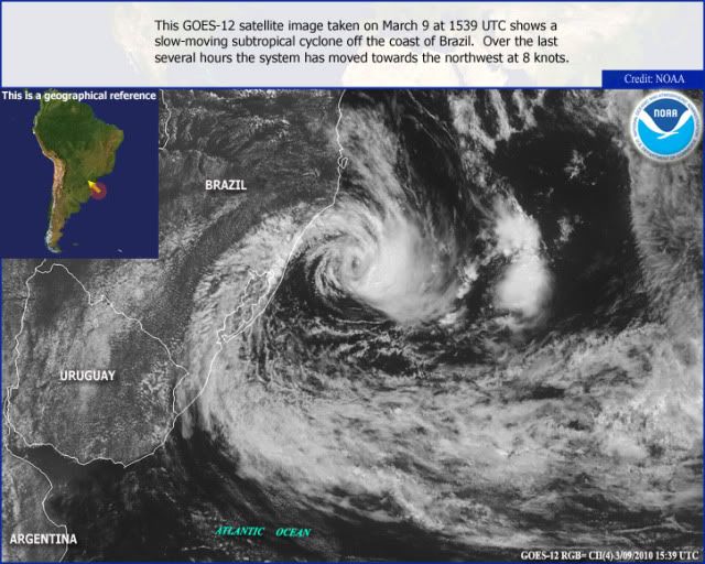
A rare weather event is underway in the South Atlantic Ocean, where the basin's 7th recorded tropical or subtropical cyclone of all-time has formed. An area of disturbed weather (Invest 90Q) off the coast of Brazil, near 30S 48W, attained a well-defined surface circulation, top wind speeds of tropical depression strength (35 mph), a warm core in the bottom portion of the atmosphere, and a cold core aloft last night. If this storm had been in the North Atlantic, there is a good chance it would have been named Subtropical Depression One. However, tropical and subtropical storms are so rare in the South Atlantic that there is no official naming of depressions or storms done. The cyclone had top winds of at least 35 mph as seen on an ASCAT pass at 7:45 pm EST last night (Figure 2), and satellite estimates of the storm's intensity topped out at 40 mph (minimum subtropical storms strength) last night. This morning, the satellite estimates are showing that the system has weakened to a 35 mph tropical depression. There is some moderate wind shear interfering with development, and sea surface temperatures are about 25°C, which is about 1°C below what is typically needed to support a tropical storm. The storm is headed eastward out to sea, and is not a threat to any land areas. The models show the storm will lose its tropical characteristics and get absorbed by a frontal system by Saturday.
Figure 1. Morning visible satellite image of the Brazilian Invest 90Q.
Figure 2. Satellite-measured winds from ASCAT clearly show the circulation of the cyclone in this pass from 7:45 pm EST on March 9, 2010. Top winds as seen be ASCAT were 35 knots (40 mph), which is the minimum strength for a subtropical storm. However, this wind barb is pointing in the opposite direction to the rotation of the storm, and may be spurious. Image credit: NOAA/NESDIS/ORA.
Brazil has had only one landfalling tropical cyclone in its history, Cyclone Catarina of March 2004. Catarina is one of only six known tropical or subtropical cyclones to form in the South Atlantic, and the only one to reach hurricane strength. Tropical cyclones rarely form in the South Atlantic Ocean, due to strong upper-level wind shear, cool water temperatures, and the lack of an initial disturbance to get things spinning (no African waves or Intertropical Convergence Zone exist in the proper locations in the South Atlantic to help spawn tropical storms). Today's storm is located close to where Catarina formed.
0 likes
Visit the Caribbean-Central America Weather Thread where you can find at first post web cams,radars
and observations from Caribbean basin members Click Here
Re: SOUTHERN ATLANTIC - INVEST 90Q
cycloneye wrote:SL, 90, 2010031012, , BEST, 0, 297S, 476W, 40, 1000, LO
ftp://ftp.tpc.ncep.noaa.gov/atcf/tcweb/ ... 010.invest
Yep goes to show this is a TS in all but name at the moment. Would it be possible for the NHC to unoffically call this one, afterall isn't that what JWTC does in the Pacific?
Or is that not possible/worth while?
0 likes
Personal Forecast Disclaimer:
The posts in this forum are NOT official forecast and should not be used as such. They are just the opinion of the poster and may or may not be backed by sound meteorological data. They are NOT endorsed by any professional institution or storm2k.org. For official information, please refer to the NHC and NWS products
-
- Tropical Storm
- Posts: 103
- Joined: Wed Dec 06, 2006 9:08 pm
- Location: São Leopoldo, Brazil
Re: SOUTHERN ATLANTIC - INVEST 90Q
cycloneye wrote:SL, 90, 2010031012, , BEST, 0, 297S, 476W, 40, 1000, LO
ftp://ftp.tpc.ncep.noaa.gov/atcf/tcweb/ ... 010.invest
40 mph or 40 kt ?
0 likes
- cycloneye
- Admin
- Posts: 139069
- Age: 67
- Joined: Thu Oct 10, 2002 10:54 am
- Location: San Juan, Puerto Rico
Re: SOUTHERN ATLANTIC - INVEST 90Q
MetSul Weather Center wrote:cycloneye wrote:SL, 90, 2010031012, , BEST, 0, 297S, 476W, 40, 1000, LO
ftp://ftp.tpc.ncep.noaa.gov/atcf/tcweb/ ... 010.invest
40 mph or 40 kt ?
40 kts
0 likes
Visit the Caribbean-Central America Weather Thread where you can find at first post web cams,radars
and observations from Caribbean basin members Click Here
Who is online
Users browsing this forum: No registered users and 118 guests