SATL: INVEST 90Q ("ANITA")

Moderator: S2k Moderators

Message
Author
User avatar
DanieleItalyRm
Category 1
Category 1
Posts: 486
Age: 38
Joined: Mon Sep 22, 2008 7:52 am
Location: Rome - Italy - Mediterranean sea

Re: SOUTHERN ATLANTIC - INVEST 90Q

#81 Postby DanieleItalyRm » Thu Mar 11, 2010 12:25 pm

You remember Karl, Vince, Laura, Grace over 22-24°C sea surface.
Don't let us pull our legs, the same system on the North Atlantic certainly would be classificated as 40 knt Tropical Storm, not subtropical.

Image

Image
Last edited by DanieleItalyRm on Thu Mar 11, 2010 1:20 pm, edited 2 times in total.
0 likes   

MaxiBide
Tropical Low
Tropical Low
Posts: 11
Joined: Sat Aug 28, 2004 10:09 am
Location: Bahia Blanca, Argentina

Re: SOUTHERN ATLANTIC - INVEST 90Q

#82 Postby MaxiBide » Thu Mar 11, 2010 12:47 pm

SOUTH AMERICA FORECAST DISCUSSION - INTERNATIONAL DESKS
NWS HYDROMETEOROLOGICAL PREDICTION CENTER CAMP SPRINGS MD
1221 PM EST THU MAR 11 2010

GFS DATA AT FTPPRD.NCEP.NOAA.GOV/PUB/DATA/NCCF/COM/GFS/PROD/

COR

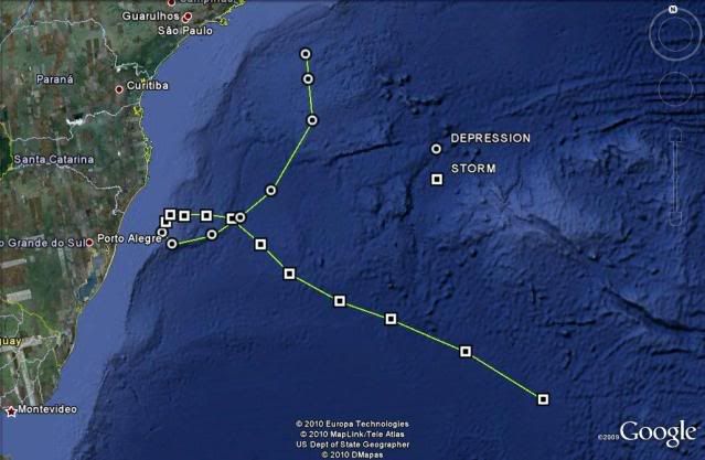
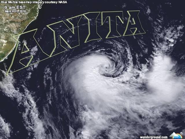
SPECIAL STATEMENT. PER NOAA NESDIS ANALYSIS...AT 12 UTC THIS
MORNING...A WARM CORE 1004 HPA LOW CENTERS NEAR 31.8 44.0W...WITH
MAXIMUM SUSTAINED WINDS OF 35KT. THE LOW IS MOVING TO THE
SOUTHEAST AT 10 KTS. THIS MOTION...IF CONTINUED...WILL TAKE THIS
SYSTEM TO COLDER WATERS WHERE IT IS EXPECTED TO EVOLVE INTO AN
EXTRATROPICAL CYCLONE. FINAL DESIGNATION...HOWEVER...IS AT THE
JUDGEMENT OF BRAZILIAN AUTHORITIES.


PLEASE VISIT THE FOLLOWING FOR OFFICIAL FORECAST:

http://www.mar.mil.br/dhn/chm/meteo/pre ... timing.htm
http://tempo1.cptec.inpe.br/

MODEL COMPARISON (VALID FROM 00Z MAR 11). THE GLOBAL MODELS NOW
AGREE ON THE INTENSITY OF A SOUTHERN STREAM PERTURBATION THAT
LIFTS ACROSS THE DRAKE PASSAGE/TIERRA DEL FUEGO THROUGH 48-54
HRS. THE TENDENCY OVER THE LAST FEW CYCLES HAS BEEN IN FAVOR OF A
DEEPER PERTURBATION...WITH ASSOCIATED SURFACE LOW TO DEEPEN FROM
A 995 HPA LOW TO A 964 HPA LOW BY 48 HRS. THIS IS 31 HPA IN 24
HRS...MAKING THIS SYSTEM A METEOROLOGICAL BOMB. VARIANCE AMONG
THE GLOBAL ENSEMBLES IS SMALL ENOUGH TO FAVOR A HIGH CONFIDENCE
FORECAST THROUGH DAY 04.

THE MODELS CONTINUE TO FORECAST THE UPPER PATTERN ACROSS NORTHERN
SOUTH AMERICA TO GRADUALLY EVOLVE THROUGH DAYS 02-03...AS A CELL
OF THE SUBTROPICAL RIDGE COMES TO DOMINATE PERU-WESTERN BRASIL
AND BOLIVIA. THE RIDGE IS TO CENTER ON A CLOSED HIGH OVER
SOUTHERN PERU/LAKE TITICACA REGION. THE BUILDING RIDGE IS TO
DISPLACE A SHORT WAVE TROUGH OVER MID SECTIONS OF SOUTH AMERICA
TO THE EAST-SOUTHEAST INTO THE WESTERN ATLANTIC THROUGH 48-60
HRS. THIS IS TO THEN MERGE WITH THE CAVADO DO NORDESTE IN SUPPORT
OF A BROAD TROUGH ON THE OFFSHORE WATERS OF NORTHEAST BRASIL. AS
THE RIDGE ESTABLISHES...CONVECTIVE ACTIVITY ACROSS NORTHERN
BOLIVIA-PERU AND AMAZONAS/RONDONIA IN WESTERN BRASIL WILL BECOME
MORE ACTIVE AND BETTER ORGANIZED... WITH MAXIMA OF 20-40MM/DAY.
OTHER ACTIVITY IS TO BUILD ALONG A LINE FROM BAHIA/MINAS GERAIS
TO THE NORTHWEST ACROSS PARA TO NORTHERN AMAZONAS/SOUTHERN
COLOMBIA. A MAXIMA OF 20-45MM/DAY WILL CONCENTRATE OVER WESTERN
BRASIL-PERU AND SOUTHERN COLOMBIA. THIS WILL WANE TO 20-35MM/DAY
BY MID CYCLE...WITH ACTIVITY TO PERSIST THROUGH DAY 05.

OVER THE EASTERN PACIFIC...AT MID/UPPER LEVELS...A BLOCKING RIDGE
PATTERN CONTINUES TO DEVELOP BETWEEN 110W-80W AND TO THE NORTH OF
55S. THE BUILDING RIDGE WILL SUSTAIN THE NORTHWARD AMPLIFICATION
OF A TROUGH OVER THE WESTERN ATLANTIC THROUGH 48 HRS...WITH BROAD
TROUGH PATTERN TO DOMINATE AREA BETWEEN 70W-25W AND TO THE SOUTH
OF 30S DURING THE NEXT FIVE TO SIX DAYS. THE FEATURE OF CONCERN
IS A CLIPPER LOW THAT RAPIDLY PULLS ACROSS THE BELLINGSHAUSEN SEA
INTO STRAITS OF MAGELLAN/TIERRA DEL FUEGO THROUGH 48-54 HRS...
WITH FEATURE TO THEN MOVE EAST OF THE MALVINAS/FALKLAND ISLANDS
BY 72 HRS...TO THEN SLOWLY PULL TO THE EAST-SOUTHEAST. AT LOW
LEVELS IT WILL SUSTAIN A DEEP LOW OVER THE DRAKE PASSAGE THAT
MOVES IN TANDEM WITH THE UPPER LEVEL SYSTEM. AS PREVIOUSLY
INDICATED...MODELS AGREE ON THIS SYSTEM BECOMING A METEOROLOGICAL
BOMB AS IT ENTERS TIERRA DEL FUEGO. STRONG WINDS IN EXCESS OF
50KT ARE TO ACCOMPANY THIS SYSTEM. ALTHOUGH WE EXPECT RAINFALL
AMOUNTS OF 20-40MM/DAY ON DAY 02...LOCALIZED MAXIMA OF 100MM ARE
POSSIBLE ON THE OFFSHORE ISLANDS. ALSO NOTE THAT THE GFS MODEL
SHOWS FAVORABLE CONDITIONS FOR SNOW SHOWERS ON THE SOUTHERN
ANDES. THROUGH DAY 03 THE DEEP/OCCLUDED LOW WILL MOVE EAST OF THE
MALVINAS/FALKLAND ISLANDS...DRAWING THE FRONT NORTH ACROSS RIO DE
LA PLATA BASIN TO CENTRAL ARGENTINA...WHERE IT IS EXPECTED TO
MEANDER.

FLORES...SENAMHI (PERU)
LLANQUE...SENAMHI (BOLIVIA)
DAVISON...HPC (USA)
0 likes   

tolakram
Admin
Admin
Posts: 19167
Age: 60
Joined: Sun Aug 27, 2006 8:23 pm
Location: Florence, KY (name is Mark)

Re: SOUTHERN ATLANTIC - INVEST 90Q

#83 Postby tolakram » Thu Mar 11, 2010 4:22 pm

.... and away it goes ....

Image
0 likes   
M a r k
- - - - -
Join us in chat: Storm2K Chatroom Invite. Android and IOS apps also available.

The posts in this forum are NOT official forecasts and should not be used as such. Posts are NOT endorsed by any professional institution or STORM2K.org. For official information and forecasts, please refer to NHC and NWS products.

User avatar
HURAKAN
Professional-Met
Professional-Met
Posts: 46086
Age: 37
Joined: Thu May 20, 2004 4:34 pm
Location: Key West, FL
Contact:

#84 Postby HURAKAN » Thu Mar 11, 2010 5:05 pm

11/1745 UTC 32.9S 42.3W EXTRATROPICAL INVEST -- South Atlantic

It was good while it lasted!
0 likes   

User avatar
KWT
Category 5
Category 5
Posts: 31391
Joined: Tue Aug 17, 2004 11:02 am
Location: UK!!!

#85 Postby KWT » Thu Mar 11, 2010 5:31 pm

Yeah looking like its undergoing ET, still a very pretty low though, and only the 7th TS of the S.Atlantic ever...not bad going!
0 likes   
Personal Forecast Disclaimer:
The posts in this forum are NOT official forecast and should not be used as such. They are just the opinion of the poster and may or may not be backed by sound meteorological data. They are NOT endorsed by any professional institution or storm2k.org. For official information, please refer to the NHC and NWS products

User avatar
HURAKAN
Professional-Met
Professional-Met
Posts: 46086
Age: 37
Joined: Thu May 20, 2004 4:34 pm
Location: Key West, FL
Contact:

#86 Postby HURAKAN » Thu Mar 11, 2010 11:46 pm

Image

Bye, bye, baby
0 likes   

User avatar
HURAKAN
Professional-Met
Professional-Met
Posts: 46086
Age: 37
Joined: Thu May 20, 2004 4:34 pm
Location: Key West, FL
Contact:

#87 Postby HURAKAN » Thu Mar 11, 2010 11:57 pm

Link : http://www.metsul.com/blog/

In Portuguese, but a lot of information and images about this system
0 likes   

User avatar
Cyclenall
Category 5
Category 5
Posts: 6628
Joined: Thu Jun 08, 2006 10:01 pm
Location: Ontario, Canada

Re: SOUTHERN ATLANTIC - INVEST 90Q

#88 Postby Cyclenall » Fri Mar 12, 2010 1:48 am

How could I miss this one? I even logged in on Tuesday! :roll: This was quite amazing for the south Atlantic for sure and probably among the most impressive since Cyclone Catrina of 2004. I thought it was very odd the NRL or NHC went with 90Q because I recall another invest in the SA that was some other letter (not SL or L) a few years back.

wxman57 wrote:NHC has no jurisdiction off Brazil. I did hear that the NHC is working with the Brazilian Met agency as far as the analysis of this storm. But there's no naming convention down there and this storm will not impact any land areas, so it'll likely just stay unnamed.

It's 2010 and there is still un-named tropical cyclones on the board? Ridiculous.

I did see the HWRF and GFDL model runs of Invest 90Q and I laughed when the HWRF was showing a non-tropical low pressure system off the coast of Greenland as 90Q! :lol:
0 likes   

User avatar
senorpepr
Military Met/Moderator
Posts: 12542
Age: 41
Joined: Fri Aug 22, 2003 9:22 pm
Location: Mackenbach, Germany
Contact:

Re: SOUTHERN ATLANTIC - INVEST 90Q

#89 Postby senorpepr » Fri Mar 12, 2010 4:03 am

Cyclenall wrote:I thought it was very odd the NRL or NHC went with 90Q because I recall another invest in the SA that was some other letter (not SL or L) a few years back.


The only other one I remember was Catarina, which ran under the suffix T. I don't have my normal files with me, but if I remember correctly it was numbered 50T.
0 likes   

User avatar
DanieleItalyRm
Category 1
Category 1
Posts: 486
Age: 38
Joined: Mon Sep 22, 2008 7:52 am
Location: Rome - Italy - Mediterranean sea

Re: SOUTHERN ATLANTIC - INVEST 90Q

#90 Postby DanieleItalyRm » Fri Mar 12, 2010 6:31 am

senorpepr wrote:
Cyclenall wrote:I thought it was very odd the NRL or NHC went with 90Q because I recall another invest in the SA that was some other letter (not SL or L) a few years back.


The only other one I remember was Catarina, which ran under the suffix T. I don't have my normal files with me, but if I remember correctly it was numbered 50T.


South Atlantic tropical cyclone:
http://en.wikipedia.org/wiki/South_Atla ... al_cyclone
0 likes   

User avatar
P.K.
Professional-Met
Professional-Met
Posts: 5149
Joined: Thu Sep 23, 2004 5:57 pm
Location: Watford, England
Contact:

Re: SOUTHERN ATLANTIC - INVEST 90Q

#91 Postby P.K. » Fri Mar 12, 2010 8:17 am

senorpepr wrote:The only other one I remember was Catarina, which ran under the suffix T. I don't have my normal files with me, but if I remember correctly it was numbered 50T.


It is listed as 50L on the NRL. I seem to remember it was the UKMO who gave it the T suffix? T makes more sense to me than Q or SL.
0 likes   

User avatar
senorpepr
Military Met/Moderator
Posts: 12542
Age: 41
Joined: Fri Aug 22, 2003 9:22 pm
Location: Mackenbach, Germany
Contact:

Re: SOUTHERN ATLANTIC - INVEST 90Q

#92 Postby senorpepr » Fri Mar 12, 2010 8:27 am

P.K. wrote:
senorpepr wrote:The only other one I remember was Catarina, which ran under the suffix T. I don't have my normal files with me, but if I remember correctly it was numbered 50T.


It is listed as 50L on the NRL. I seem to remember it was the UKMO who gave it the T suffix? T makes more sense to me than Q or SL.


You know--you're absolutely right. NRL did list it as 50L while UKMO used the T suffix. I agree... T seems more reasonable to me versus Q.
0 likes   

Derek Ortt

#93 Postby Derek Ortt » Fri Mar 12, 2010 9:18 am

operationally, Catarina was 01L, changed to 50 after the season
0 likes   

User avatar
HURAKAN
Professional-Met
Professional-Met
Posts: 46086
Age: 37
Joined: Thu May 20, 2004 4:34 pm
Location: Key West, FL
Contact:

#94 Postby HURAKAN » Fri Mar 12, 2010 9:48 am

Image

Latest
0 likes   

User avatar
senorpepr
Military Met/Moderator
Posts: 12542
Age: 41
Joined: Fri Aug 22, 2003 9:22 pm
Location: Mackenbach, Germany
Contact:

Re:

#95 Postby senorpepr » Fri Mar 12, 2010 10:03 am

Derek Ortt wrote:operationally, Catarina was 01L, changed to 50 after the season


That's right, Derek. I was looking through the archives here and it was listed as 01L as the storm progressed. I want to say they changed it to 50L at some point before the end of the season--before the real 01L developed.
0 likes   

User avatar
HURAKAN
Professional-Met
Professional-Met
Posts: 46086
Age: 37
Joined: Thu May 20, 2004 4:34 pm
Location: Key West, FL
Contact:

#96 Postby HURAKAN » Fri Mar 12, 2010 10:41 am

Image

Best Track has been updated and intensity increased to 45 knots and pressure down to 995 mb.

Link : ftp://ftp.tpc.ncep.noaa.gov/atcf/tcweb/ ... 010.invest
0 likes   

MetSul Weather Center
Tropical Storm
Tropical Storm
Posts: 103
Joined: Wed Dec 06, 2006 9:08 pm
Location: São Leopoldo, Brazil

Re: SOUTHERN ATLANTIC - INVEST 90Q

#97 Postby MetSul Weather Center » Fri Mar 12, 2010 12:45 pm

STATEMENT

RARE SOUTH ATLANTIC TROPICAL STORM DESIGNATED ANITA

The regional weather centers and the private weather enterprises of both Rio Grande do Sul and Santa Catarina, southernmost Brazilian states, in a joint decision, named Anita the rare tropical storm of March 9th and 10th in the coastal areas of the region. The name was chosen considering a historic figure of Rio Grande do Sul and Santa Catarina, both states affected by the tropical cyclone. Anita Garibaldi (1821-1849) was a heroin of the Farroupilha Revolution (1835-1845), one of the most important events in the Brazilian history that took place in the Southern part of the country. Anita was used in the past to designate tropical cyclones in other basins: North Atlantic, the Pacific and the Indian Ocean.

*
Ciram/Epagri (Florianópolis - SC)
*
Atmosfera Meteorologia (Pelotas - RS)
*
Central RBS de Meteorologia (Porto Alegre - RS e Florianópolis - SC)
*
Climaterra (São Joaquim - SC)
*
Fundação de Apoio ao Desenvolvimento Rural de SC (Florianópolis - SC)
*
MetSul Meteorologia (São Leopoldo - RS)
0 likes   

User avatar
HURAKAN
Professional-Met
Professional-Met
Posts: 46086
Age: 37
Joined: Thu May 20, 2004 4:34 pm
Location: Key West, FL
Contact:

#98 Postby HURAKAN » Fri Mar 12, 2010 1:01 pm

Image

Great to see that it was named.
0 likes   

User avatar
KWT
Category 5
Category 5
Posts: 31391
Joined: Tue Aug 17, 2004 11:02 am
Location: UK!!!

#99 Postby KWT » Fri Mar 12, 2010 1:07 pm

Yep good to see it was named as well though would have been a little more helpful to do whilst it was still an actual storm :P

Also 45kts is pretty decent for this basin!
0 likes   
Personal Forecast Disclaimer:
The posts in this forum are NOT official forecast and should not be used as such. They are just the opinion of the poster and may or may not be backed by sound meteorological data. They are NOT endorsed by any professional institution or storm2k.org. For official information, please refer to the NHC and NWS products

User avatar
P.K.
Professional-Met
Professional-Met
Posts: 5149
Joined: Thu Sep 23, 2004 5:57 pm
Location: Watford, England
Contact:

Re: S. ATLANTIC - INVEST 90Q - Named: ANITA

#100 Postby P.K. » Fri Mar 12, 2010 1:52 pm

Has this been named officially by the Brazilian authorities? I can't see anything on the website. http://www.inmet.gov.br/
0 likes   


Return to “2010”

Who is online

Users browsing this forum: No registered users and 43 guests