ATL : INVEST 90L - DISCUSSION
Moderator: S2k Moderators
- StormTracker
- S2K Supporter

- Posts: 2902
- Age: 57
- Joined: Thu Jun 29, 2006 6:06 am
- Location: Quail Heights(Redlands), FL.
Re: ATL : INVEST 90L - DISCUSSION
Blown Away, that's the million dollar question! Only time will tell, but, IMO, this scenario will be referenced for years to come when it's all done & said!
0 likes
Something's wrong when you regret, things that haven't happened yet!
Re: ATL : INVEST 90L - DISCUSSION
00Z GFS will start rolling in about 10 minutes. The 18Z run looked very reasonable and the solution offered in terms of track seemed to align very well with the forecasted synoptic environment.So im anxiously awaiting the 00z run...
0 likes
- cycloneye
- Admin

- Posts: 139078
- Age: 67
- Joined: Thu Oct 10, 2002 10:54 am
- Location: San Juan, Puerto Rico
Re: ATL : INVEST 90L - DISCUSSION
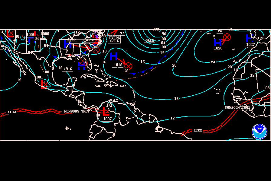
At the 00z surface analysis, the low that was 90L dissipates.


0 likes
Visit the Caribbean-Central America Weather Thread where you can find at first post web cams,radars
and observations from Caribbean basin members Click Here
and observations from Caribbean basin members Click Here
- Ivanhater
- Storm2k Moderator

- Posts: 10852
- Age: 37
- Joined: Fri Jul 01, 2005 8:25 am
- Location: Pensacola
Re: ATL : INVEST 90L - DISCUSSION
I think 90L as its own entity may have been designated to early. The models for the most part have been combining a couple areas, not developing one low pressure area like we tend to see...
0 likes
Michael
Re: ATL : INVEST 90L - DISCUSSION
315utc imagery implies system becoming better organized with a well defined moisture envelope, inflow beginning and an improving upper-air pattern. The process should contiue gradual and I would expect the possibility of Colin later Monday...Tomorrow should make for some interesting visibles...
0 likes
- lester
- S2K Supporter

- Posts: 1305
- Age: 35
- Joined: Sat Aug 27, 2005 5:21 pm
- Location: Washington, DC
- Contact:
Re: ATL : INVEST 90L - DISCUSSION
cycloneye wrote:At the 00z surface analysis, the low that was 90L dissipates.
So will they deactivate it or leave it as 90L?
0 likes
- cycloneye
- Admin

- Posts: 139078
- Age: 67
- Joined: Thu Oct 10, 2002 10:54 am
- Location: San Juan, Puerto Rico
Re: ATL : INVEST 90L - DISCUSSION
So will they deactivate it or leave it as 90L?
Is hard to say if they continue with 90L tweeking back eastward the best track positions or start over with a new invest with new best track positions.
0 likes
Visit the Caribbean-Central America Weather Thread where you can find at first post web cams,radars
and observations from Caribbean basin members Click Here
and observations from Caribbean basin members Click Here
- Ivanhater
- Storm2k Moderator

- Posts: 10852
- Age: 37
- Joined: Fri Jul 01, 2005 8:25 am
- Location: Pensacola
Re: ATL : INVEST 90L - DISCUSSION
Let's make sure to keep the models in the model thread.
0 likes
Michael
-
Florida1118
- Category 5

- Posts: 1805
- Age: 27
- Joined: Sat Jun 19, 2010 12:57 pm
- Location: Tampa, Florida
Re: ATL : INVEST 90L - DISCUSSION
A LARGE AREA OF DISORGANIZED SHOWERS AND THUNDERSTORMS OVER THE
EASTERN ATLANTIC OCEAN IS ASSOCIATED WITH A TROPICAL WAVE NEAR THE
CAPE VERDE ISLANDS AND A SMALL TROUGH OF LOW PRESSURE LOCATED ABOUT
750 MILES SOUTHWEST OF THE CAPE VERDE ISLANDS. DEVELOPMENT OF
EITHER SYSTEM...IF ANY...SHOULD BE SLOW TO OCCUR...AND THERE IS A
LOW CHANCE...20 PERCENT...OF TROPICAL CYCLONE FORMATION IN THIS
AREA DURING THE NEXT 48 HOURS.
0 likes
- Ivanhater
- Storm2k Moderator

- Posts: 10852
- Age: 37
- Joined: Fri Jul 01, 2005 8:25 am
- Location: Pensacola
Re: ATL : INVEST 90L - DISCUSSION
I find it interesting the NHC has not dropped the percentage at all and has maintained 20 percent throughout. This leads me to believe they think this has a good shot
0 likes
Michael
-
Vortmax1
- Category 1

- Posts: 360
- Joined: Wed Jul 07, 2010 11:35 pm
- Location: Port Salerno, FL
- Contact:
TROPICAL WEATHER DISCUSSION
NWS TPC/NATIONAL HURRICANE CENTER MIAMI FL
805 AM EDT SAT JUL 31 2010
...TROPICAL WAVES...
AN ATLANTIC OCEAN TROPICAL WAVE IS ALONG 16N19W 11N21W 6N22W
MOVING WESTWARD 10 TO 15 KT. SCATTERED STRONG SHOWERS AND
THUNDERSTORMS ARE FROM 5N TO 7N BETWEEN 22W AND 24W...AND
FROM 9N TO 12N BETWEEN 22W AND 30W.
THE 1010 MB LOW PRESSURE CENTER THAT WAS NEAR 10N34W SIX HOURS
AGO HAS DISSIPATED. A SURFACE TROUGH REMAINS ALONG 34W/35W
FROM 7N TO 13N. ANY OF THE PRECIPITATION THAT JUST IS RELATED TO
THIS TROPICAL WAVE UNDOUBTEDLY IS MIXED WITH THE ITCZ SCATTERED
STRONG SHOWERS AND THUNDERSTORMS THAT ARE FROM 2N TO 10N BETWEEN
32W AND 43W.
It appears they are dropping this Invest?
0 likes
- cycloneye
- Admin

- Posts: 139078
- Age: 67
- Joined: Thu Oct 10, 2002 10:54 am
- Location: San Juan, Puerto Rico
Re: ATL : INVEST 90L - DISCUSSION
Remains at 20%.
TROPICAL WEATHER OUTLOOK
NWS TPC/NATIONAL HURRICANE CENTER MIAMI FL
800 AM EDT SAT JUL 31 2010
FOR THE NORTH ATLANTIC...CARIBBEAN SEA AND THE GULF OF MEXICO...
SHOWER AND THUNDERSTORM ACTIVITY ASSOCIATED WITH A TROPICAL WAVE
OVER THE CENTRAL CARIBBEAN SEA HAS DIMINISHED. ANY DEVELOPMENT OF
THIS SYSTEM SHOULD BE SLOW TO OCCUR...BUT THERE IS STILL A LOW
CHANCE...20 PERCENT...THAT IT WILL BECOME A TROPICAL CYCLONE DURING
THE NEXT 48 HOURS AS IT MOVES WESTWARD AT ABOUT 15 MPH INTO THE
SOUTHWESTERN CARIBBEAN SEA.
A TROPICAL WAVE OVER THE FAR EASTERN ATLANTIC OCEAN AND A SMALL
TROUGH OF LOW PRESSURE LOCATED ABOUT 800 MILES SOUTHWEST OF THE
CAPE VERDE ISLANDS ARE PRODUCING A LARGE AND DISORGANIZED AREA OF
SHOWERS AND THUNDERSTORMS. DEVELOPMENT OF EITHER SYSTEM SHOULD BE
SLOW TO OCCUR...AND THERE IS A LOW CHANCE...20 PERCENT...OF
TROPICAL CYCLONE FORMATION IN THIS AREA DURING THE NEXT 48 HOURS.
ELSEWHERE...TROPICAL CYCLONE FORMATION IS NOT EXPECTED DURING THE
NEXT 48 HOURS.
$$
FORECASTER BERG

0 likes
Visit the Caribbean-Central America Weather Thread where you can find at first post web cams,radars
and observations from Caribbean basin members Click Here
and observations from Caribbean basin members Click Here
- cycloneye
- Admin

- Posts: 139078
- Age: 67
- Joined: Thu Oct 10, 2002 10:54 am
- Location: San Juan, Puerto Rico
Re: ATL : INVEST 90L - DISCUSSION
The question about invest 90L being deactivated or not has been answered.
ftp://ftp.tpc.ncep.noaa.gov/atcf/tcweb/ ... 902010.ren
NHC_ATCF
invest_DEACTIVATE_al902010.ren
FSTDA
R
U
040
010
0000
201007311150
NONE
NOTIFY=ATRP
END
ftp://ftp.tpc.ncep.noaa.gov/atcf/tcweb/ ... 902010.ren
NHC_ATCF
invest_DEACTIVATE_al902010.ren
FSTDA
R
U
040
010
0000
201007311150
NONE
NOTIFY=ATRP
END
0 likes
Visit the Caribbean-Central America Weather Thread where you can find at first post web cams,radars
and observations from Caribbean basin members Click Here
and observations from Caribbean basin members Click Here
- wxman57
- Moderator-Pro Met

- Posts: 22482
- Age: 66
- Joined: Sat Jun 21, 2003 8:06 pm
- Location: Houston, TX (southwest)
Re: ATL : INVEST 90L - DISCUSSION
Ivanhater wrote:I find it interesting the NHC has not dropped the percentage at all and has maintained 20 percent throughout. This leads me to believe they think this has a good shot
FYI, we were doing some calculations yesterday on probability of development of tropical waves in August and September. Since we've been counting the waves since about 2004, we have records of how many moved off the coast of Africa during each month and of how many of them developed. On average, any wave in August has a 20-30% chance of development. Chances go up to 30-40% in September. So, statistically, a 20% chance of development would be below average for August.
Really, these estimates are little more than an educated guess by the forecaster based upon what he/she is presently observing in terms of organization. One could certainly argue that the current state of the wave would indicate about zero chance of development within 48 hrs, but possibly 30-40% in the very long term (in 6-8 days) when it reaches the central to western Caribbean Sea. That would be just slightly higher than average for August.
0 likes
Who is online
Users browsing this forum: No registered users and 100 guests


