Summary of new 15Z advisory:
ZCZC MIATCPAT4 ALL
TTAA00 KNHC DDHHMM
BULLETIN
TROPICAL STORM COLIN ADVISORY NUMBER 11
NWS TPC/NATIONAL HURRICANE CENTER MIAMI FL AL042010
1100 AM AST FRI AUG 06 2010
...CENTER OF COLIN MEANDERING EAST-NORTHEASTWARD...EXPECTED TO MOVE
NORTHWARD LATER TODAY...
SUMMARY OF 1100 AM AST...1500 UTC...INFORMATION
-----------------------------------------------
LOCATION...27.1N 66.9W
ABOUT 380 MI...615 KM SSW OF BERMUDA
MAXIMUM SUSTAINED WINDS...45 MPH...75 KM/HR
PRESENT MOVEMENT...ENE OR 65 DEGREES AT 7 MPH...11 KM/HR
MINIMUM CENTRAL PRESSURE...1007 MB...29.74 INCHES
<snip>
And from forecast discussion:
FORECAST POSITIONS AND MAX WINDS
INITIAL 06/1500Z 27.1N 66.9W 40 KT
12HR VT 07/0000Z 28.3N 66.9W 40 KT
24HR VT 07/1200Z 30.2N 66.3W 45 KT
36HR VT 08/0000Z 32.2N 65.4W 50 KT
48HR VT 08/1200Z 34.5N 64.1W 55 KT
72HR VT 09/1200Z 39.5N 60.0W 60 KT
96HR VT 10/1200Z 45.0N 52.0W 55 KT...POST-TROP/EXTRATROP
120HR VT 11/1200Z 53.0N 41.5W 50 KT...POST-TROP/EXTRATROP
ATL: Ex COLIN - Discussion
Moderator: S2k Moderators
Two flights into Colin for today, with the first scheduled to take off in minutes:
And one last flight scheduled for tomorrow from today's recon POD for tomorrow:
000
NOUS42 KNHC 051345
WEATHER RECONNAISSANCE FLIGHTS
CARCAH, NATIONAL HURRICANE CENTER, MIAMI, FL.
0945 AM EDT THU 05 AUGUST 2010
SUBJECT: TROPICAL CYCLONE PLAN OF THE DAY (TCPOD)
VALID 06/1100Z TO 07/1100Z AUGUST 2010
TCPOD NUMBER.....10-067
I. ATLANTIC REQUIREMENTS
1. REMNANTS OF TROPICAL STORM COLIN
FLIGHT ONE -- TEAL 70
A. 06/1800Z
B. AFXXX 0304A COLIN
C. 06/1530Z
D. 27.7N 67.5W
E. 06/1730Z TO 06/2130Z
F. SFC TO 15,000 FT
FLIGHT TWO -- TEAL 71
A. 07/0600Z
B. AFXXX 0404A COLIN
C. 07/0315Z
D. 29.2N 67.3W
E. 07/0530Z TO 07/0930Z
F. SFC TO 15,000 FT
2. OUTLOOK FOR SUCCEEDING DAY: A POSSIBLE FIX OF THE
SYSTEM NEAR 33.0N 66.0W AT 07/1800Z.
1. NEGATIVE RECONNAISSANCE REQUIREMENTS.
2. SUCCEEDING DAY OUTLOOK.....NEGATIVE.
JWP
And one last flight scheduled for tomorrow from today's recon POD for tomorrow:
000
NOUS42 KNHC 061500 COR
WEATHER RECONNAISSANCE FLIGHTS
CARCAH, NATIONAL HURRICANE CENTER, MIAMI, FL.
1100 AM EDT FRI 06 AUGUST 2010
SUBJECT: TROPICAL CYCLONE PLAN OF THE DAY (TCPOD)
VALID 07/1100Z TO 08/1100Z AUGUST 2010
TCPOD NUMBER.....10-068 CORRECTION
I. ATLANTIC REQUIREMENTS
1. TROPICAL STORM COLIN
FLIGHT ONE -- TEAL 72...CORRECTED
A. 07/1800Z
B. AFXXX 0504A COLIN
C. 07/1400Z
D. 31.2N 65.9W
E. 07/1630Z TO 07/2030Z
F. SFC TO 15,000 FT
2. OUTLOOK FOR SUCCEEDING DAY.....NEGATIVE.
II. PACIFIC REQUIREMENTS
1. NEGATIVE RECONNAISSANCE REQUIREMENTS.
2. SUCCEEDING DAY OUTLOOK.....NEGATIVE.
JWP
0 likes
Map of satellite, surface/ship/buoy obs, shear, and model tracks made from CIMSS TCTrak:

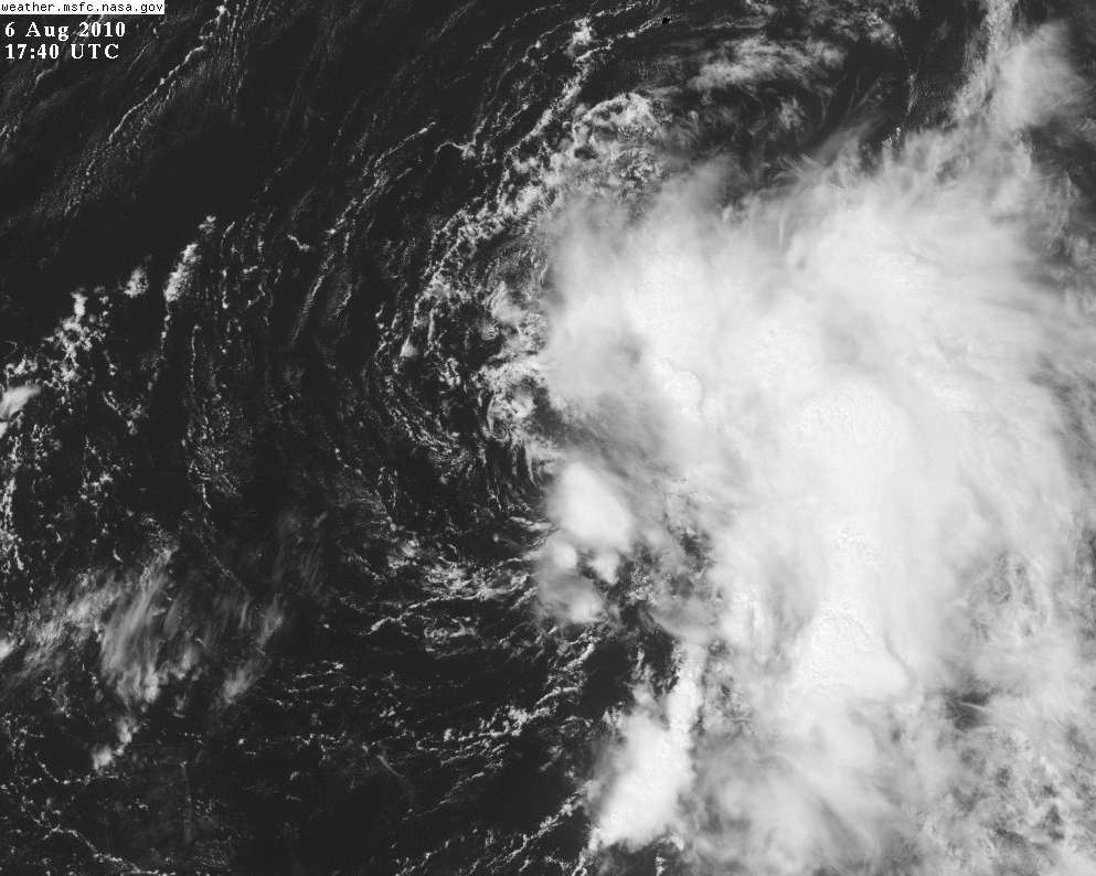
You can easily see what NHC described in the earlier forecast discussion from 9Z:
You can easily see what NHC described in the earlier forecast discussion from 9Z:
COLIN IS SITUATED TO THE SOUTHEAST OF AN
UPPER-LEVEL SHEAR AXIS ANCHORED BY ONE LOW CENTER NEAR 27N 75W AND
ANOTHER NEAR BERMUDA.
0 likes
-
tolakram
- Admin

- Posts: 19165
- Age: 60
- Joined: Sun Aug 27, 2006 8:23 pm
- Location: Florence, KY (name is Mark)
Re: ATL : Tropical Storm Colin - DISCUSSION
Centers and eddies.
0 likes
M a r k
- - - - -
Join us in chat: Storm2K Chatroom Invite. Android and IOS apps also available.
The posts in this forum are NOT official forecasts and should not be used as such. Posts are NOT endorsed by any professional institution or STORM2K.org. For official information and forecasts, please refer to NHC and NWS products.
Re: ATL : Tropical Storm Colin - DISCUSSION
this stinkin storm.....i need it to hold together so it can send a nice swell up the coast for monday
anyone have any idea about the fetch of winds aimed toward SNE from this system.....say the winds in the eastern quad blowing S or SE
with the absense of quikscat anyone have an idea
anyone have any idea about the fetch of winds aimed toward SNE from this system.....say the winds in the eastern quad blowing S or SE
with the absense of quikscat anyone have an idea
0 likes
-
hurricaneCW
- Category 5

- Posts: 1773
- Joined: Wed Mar 03, 2010 6:20 am
- Location: Toms River, NJ
Re: ATL : Tropical Storm Colin - DISCUSSION
Well so much for any decrease in shear. Looks like a total mess. Good for Bermuda though, just a few heavy squalls and gusty winds, but nothing major. It'll probably become stronger once baroclinic forces kick in.
0 likes
-
Category 5

- Category 5
- Posts: 10074
- Age: 34
- Joined: Sun Feb 11, 2007 10:00 pm
- Location: New Brunswick, NJ
- Contact:
Re: ATL : Tropical Storm Colin - DISCUSSION
Looked like it had two circulations for a while or am I blind?
0 likes

"GAME SET MATCH GIANTS WILL WIN THE NFC EAST and have a FIRST ROUND BYE with a win next week!!!" - StormingB81, the Giants lost, and did not win the NFC east.
-
brunota2003

- S2K Supporter

- Posts: 9476
- Age: 33
- Joined: Sat Jul 30, 2005 9:56 pm
- Location: Stanton, KY...formerly Havelock, NC
- Contact:
-
cycloneye

- Admin
- Posts: 139027
- Age: 67
- Joined: Thu Oct 10, 2002 10:54 am
- Location: San Juan, Puerto Rico
Re: ATL : Tropical Storm Colin - DISCUSSION
Category 5 wrote:Looked like it had two circulations for a while or am I blind?
No, your are not blind as there are two. One smaller to the north of the main and bigger circulation.

0 likes
Visit the Caribbean-Central America Weather Thread where you can find at first post web cams,radars
and observations from Caribbean basin members Click Here
and observations from Caribbean basin members Click Here


-
Category 5
- Category 5
- Posts: 10074
- Age: 34
- Joined: Sun Feb 11, 2007 10:00 pm
- Location: New Brunswick, NJ
- Contact:
Re: ATL : Tropical Storm Colin - DISCUSSION
cycloneye wrote:Category 5 wrote:Looked like it had two circulations for a while or am I blind?
No, your are not blind as there are two. One smaller to the north of the main and bigger circulation.
That might temporarily put the brakes on it significantly strengthening, still thinking Hurricane strength near its ETT is a good bet at this point though.
0 likes
"GAME SET MATCH GIANTS WILL WIN THE NFC EAST and have a FIRST ROUND BYE with a win next week!!!" - StormingB81, the Giants lost, and did not win the NFC east.

Oh yeah it sure does look like it has a multiple vortex feature...
Also note the NHC now take this pretty kuch over Bermuda, could get a direct hit from this system given the bend to the NNE.
Also note the NHC now take this pretty kuch over Bermuda, could get a direct hit from this system given the bend to the NNE.
0 likes
Personal Forecast Disclaimer:
The posts in this forum are NOT official forecast and should not be used as such. They are just the opinion of the poster and may or may not be backed by sound meteorological data. They are NOT endorsed by any professional institution or storm2k.org. For official information, please refer to the NHC and NWS products
The posts in this forum are NOT official forecast and should not be used as such. They are just the opinion of the poster and may or may not be backed by sound meteorological data. They are NOT endorsed by any professional institution or storm2k.org. For official information, please refer to the NHC and NWS products
-
hurricaneCW
- Category 5
- Posts: 1773
- Joined: Wed Mar 03, 2010 6:20 am
- Location: Toms River, NJ
Re: ATL : Tropical Storm Colin - DISCUSSION
Poor thing looks sheared to bits. Thank god for that immediate burst or it could have been done for.
0 likes
Oh it is a complete mess, but its a classic example of how you can get something going even in a very sheared set-up, just don't expect it to be explosivly strong!
0 likes
Personal Forecast Disclaimer:
The posts in this forum are NOT official forecast and should not be used as such. They are just the opinion of the poster and may or may not be backed by sound meteorological data. They are NOT endorsed by any professional institution or storm2k.org. For official information, please refer to the NHC and NWS products
The posts in this forum are NOT official forecast and should not be used as such. They are just the opinion of the poster and may or may not be backed by sound meteorological data. They are NOT endorsed by any professional institution or storm2k.org. For official information, please refer to the NHC and NWS products
-
hurricaneCW
- Category 5
- Posts: 1773
- Joined: Wed Mar 03, 2010 6:20 am
- Location: Toms River, NJ
Re:
KWT wrote:Oh it is a complete mess, but its a classic example of how you can get something going even in a very sheared set-up, just don't expect it to be explosivly strong!
It's called 2009, or TS Chris
0 likes
The fact it developed two circulations probably shows just how weak the actual main circulation has become, really wouldn't take much for the whole thing to open up and become a multiple vortex mess with little secondary depression like features rotating around.
0 likes
Personal Forecast Disclaimer:
The posts in this forum are NOT official forecast and should not be used as such. They are just the opinion of the poster and may or may not be backed by sound meteorological data. They are NOT endorsed by any professional institution or storm2k.org. For official information, please refer to the NHC and NWS products
The posts in this forum are NOT official forecast and should not be used as such. They are just the opinion of the poster and may or may not be backed by sound meteorological data. They are NOT endorsed by any professional institution or storm2k.org. For official information, please refer to the NHC and NWS products
-
Epsilon_Fan

- Category 1

- Posts: 353
- Joined: Fri Jan 13, 2006 1:03 pm
- Location: Charleston, SC
Re: ATL : Tropical Storm Colin - DISCUSSION
Any chance that the circulation relocates under the main burst of convection? There seems to be a vortex heading east and one going north
0 likes
You can't rule it out given the state of the system, its not exactly well organised so just keep an eye on it just in case!
0 likes
Personal Forecast Disclaimer:
The posts in this forum are NOT official forecast and should not be used as such. They are just the opinion of the poster and may or may not be backed by sound meteorological data. They are NOT endorsed by any professional institution or storm2k.org. For official information, please refer to the NHC and NWS products
The posts in this forum are NOT official forecast and should not be used as such. They are just the opinion of the poster and may or may not be backed by sound meteorological data. They are NOT endorsed by any professional institution or storm2k.org. For official information, please refer to the NHC and NWS products
-
Gustywind

- Category 5
- Posts: 12334
- Joined: Mon Sep 03, 2007 7:29 am
- Location: Baie-Mahault, GUADELOUPE
Colin eyes Bermuda
Tom Moore, Lead Meteorologist, The Weather Channel
Aug. 6, 2010 5:50 pm ET
Colin regained its tropical storm designation after investigation on Thursday, and as of 4 p.m. ET Friday, was centered about 300 miles south of Bermuda.
The storm is moving to the north at 9 mph, and sporting maximum sustained winds of 45 mph. Little change in strength is expected in the short term, however a slowing of its forward motion may give the storm some chance to intensify a bit into the weekend.
The forecast track takes Colin close of Bermuda by late Saturday. Tropical storm warnings remain in effect for Bermuda, meaning tropical storm-force winds are expected on the island within 36 hours. Colin will remain well east of the U.S. coast, with no impacts. rainfall totals of 3 to 5 inches could fall with the storm. Bermuda would welcome this much rainfall, however.
0 likes

Who is online
Users browsing this forum: No registered users and 36 guests