ATL: Ex INVEST 92L - Discussion
Moderator: S2k Moderators

-
lrak

- S2K Supporter

- Posts: 1770
- Age: 57
- Joined: Thu Jun 21, 2007 2:48 pm
- Location: Corpus Christi, TX
Re: ATL : INVEST 92L - DISCUSSION
Well put Sir HURAKAN “We are masters of the unsaid words, but slaves of those we let slip out.”
0 likes
AKA karl
Also
Personal Forecast Disclaimer:
My posts on this forum are NOT official forecast and should not be used as such. My posts are my basic observations and are definitely not backed by any "well some" meteorological knowledge. For official information, please refer to the NHC and NWS products.
Also
Personal Forecast Disclaimer:
My posts on this forum are NOT official forecast and should not be used as such. My posts are my basic observations and are definitely not backed by any "well some" meteorological knowledge. For official information, please refer to the NHC and NWS products.
-
HURAKAN

- Professional-Met

- Posts: 46086
- Age: 37
- Joined: Thu May 20, 2004 4:34 pm
- Location: Key West, FL
- Contact:
924
ABNT20 KNHC 070551
TWOAT
TROPICAL WEATHER OUTLOOK
NWS TPC/NATIONAL HURRICANE CENTER MIAMI FL
200 AM EDT SAT AUG 7 2010
FOR THE NORTH ATLANTIC...CARIBBEAN SEA AND THE GULF OF MEXICO...
THE NATIONAL HURRICANE CENTER IS ISSUING ADVISORIES ON TROPICAL
STORM COLIN...LOCATED ABOUT 245 MILES SOUTH-SOUTHWEST OF BERMUDA.
A LARGE AREA OF DISTURBED WEATHER OVER THE CENTRAL ATLANTIC IS
ASSOCIATED WITH AN AREA OF LOW PRESSURE LOCATED ABOUT 800 MILES WEST
OF THE CAPE VERDE ISLANDS. ENVIRONMENTAL CONDITIONS ARE FAVORABLE
FOR SLOW DEVELOPMENT OF THIS SYSTEM DURING THE NEXT COUPLE OF DAYS
AS IT MOVES TOWARD THE WEST-NORTHWEST AT AROUND 15 MPH. THERE IS A
MEDIUM CHANCE...40 PERCENT...OF THIS SYSTEM BECOMING A TROPICAL
CYCLONE DURING THE NEXT 48 HOURS.
SHOWER ACTIVITY ASSOCIATED WITH A TROPICAL WAVE OVER THE
NORTHWESTERN CARIBBEAN SEA HAS DECREASED OVER THE PAST FEW HOURS.
THERE ARE NO SIGNS OF A SURFACE CIRCULATION...AND SIGNIFICANT
DEVELOPMENT OF THIS SYSTEM IS NOT EXPECTED BEFORE IT MOVES INLAND
OVER THE YUCATAN PENINSULA AND BELIZE LATER TODAY. THERE IS A LOW
CHANCE...10 PERCENT...OF THIS SYSTEM BECOMING A TROPICAL CYCLONE
DURING THE NEXT 48 HOURS.
ELSEWHERE...TROPICAL CYCLONE FORMATION IS NOT EXPECTED DURING THE
NEXT 48 HOURS.
$$
FORECASTER BRENNAN
0 likes
-
chzzdekr81

- S2K Supporter
- Posts: 189
- Joined: Sun Aug 30, 2009 7:54 pm
- Location: Orange, Texas (SETX)
- Contact:

Looks like the main problem for this one remains to be the lack of surface support so the convection just develops then dies off again no matter how impressive it looks.
0 likes
Personal Forecast Disclaimer:
The posts in this forum are NOT official forecast and should not be used as such. They are just the opinion of the poster and may or may not be backed by sound meteorological data. They are NOT endorsed by any professional institution or storm2k.org. For official information, please refer to the NHC and NWS products
The posts in this forum are NOT official forecast and should not be used as such. They are just the opinion of the poster and may or may not be backed by sound meteorological data. They are NOT endorsed by any professional institution or storm2k.org. For official information, please refer to the NHC and NWS products
-
cycloneye

- Admin

- Posts: 139312
- Age: 67
- Joined: Thu Oct 10, 2002 10:54 am
- Location: San Juan, Puerto Rico
Re: ATL : INVEST 92L - DISCUSSION
TROPICAL WEATHER OUTLOOK
NWS TPC/NATIONAL HURRICANE CENTER MIAMI FL
800 AM EDT SAT AUG 7 2010
FOR THE NORTH ATLANTIC...CARIBBEAN SEA AND THE GULF OF MEXICO...
THE NATIONAL HURRICANE CENTER IS ISSUING ADVISORIES ON TROPICAL
STORM COLIN...LOCATED ABOUT 230 MILES SOUTH-SOUTHWEST OF BERMUDA.
THERE HAS BEEN LITTLE CHANGE WITH A LOW PRESSURE SYSTEM LOCATED
OVER THE CENTRAL ATLANTIC ABOUT 850 MILES WEST OF THE CAPE VERDE
ISLANDS. ENVIRONMENTAL CONDITIONS ARE GENERALLY FAVORABLE FOR SLOW
DEVELOPMENT OF THIS SYSTEM DURING THE NEXT COUPLE OF DAYS AS IT
MOVES TOWARD THE WEST-NORTHWEST AT AROUND 15 MPH. THERE IS A
MEDIUM CHANCE...40 PERCENT...OF THIS SYSTEM BECOMING A TROPICAL
CYCLONE DURING THE NEXT 48 HOURS.
A TROPICAL WAVE OVER THE NORTHWESTERN CARIBBEAN SEA HAS CHANGED
LITTLE IN ORGANIZATION THIS MORNING. SIGNIFICANT DEVELOPMENT OF
THIS SYSTEM IS NOT EXPECTED BEFORE IT MOVES INLAND OVER THE YUCATAN
PENINSULA AND BELIZE LATER TODAY. THERE IS A LOW CHANCE...10
PERCENT...OF THIS SYSTEM BECOMING A TROPICAL CYCLONE DURING THE
NEXT 48 HOURS.
ELSEWHERE...TROPICAL CYCLONE FORMATION IS NOT EXPECTED DURING THE
NEXT 48 HOURS.
$$
FORECASTER BLAKE
0 likes
Visit the Caribbean-Central America Weather Thread where you can find at first post web cams,radars
and observations from Caribbean basin members Click Here
and observations from Caribbean basin members Click Here

Re: ATL : INVEST 92L - DISCUSSION
Well it looks like the weak center is now moving inland very near Belize city. If doesn't gain latitude, it might not even make it onto the BOC but it probably will just so I'll have to watch it.
Now if the Mid level develops again today that might be a little different story.
Zoom in
http://rammb.cira.colostate.edu/ramsdis ... _floater_2
Belize radar
http://www.hydromet.gov.bz/Radar%20Loop%20250km.htm
Now if the Mid level develops again today that might be a little different story.
Zoom in
http://rammb.cira.colostate.edu/ramsdis ... _floater_2
Belize radar
http://www.hydromet.gov.bz/Radar%20Loop%20250km.htm
0 likes
The following post is NOT an official forecast and should not be used as such. It is just the opinion of the poster and may or may not be backed by sound meteorological data. It is NOT endorsed by any professional institution including storm2k.org For Official Information please refer to the NHC and NWS products.
-
cycloneye
- Admin
- Posts: 139312
- Age: 67
- Joined: Thu Oct 10, 2002 10:54 am
- Location: San Juan, Puerto Rico
Re: ATL : INVEST 92L - DISCUSSION
12z Best Track
AL, 92, 2010080712, , BEST, 0, 173N, 883W, 25, 1009, DB
AL, 92, 2010080712, , BEST, 0, 173N, 883W, 25, 1009, DB
0 likes
Visit the Caribbean-Central America Weather Thread where you can find at first post web cams,radars
and observations from Caribbean basin members Click Here
and observations from Caribbean basin members Click Here
Re: ATL : INVEST 92L - DISCUSSION
cycloneye wrote:12z Best Track
AL, 92, 2010080712, , BEST, 0, 173N, 883W, 25, 1009, DB
That puts it on the coast near Belize city. BUT most of the vorticity is father east.
850mb

700mb
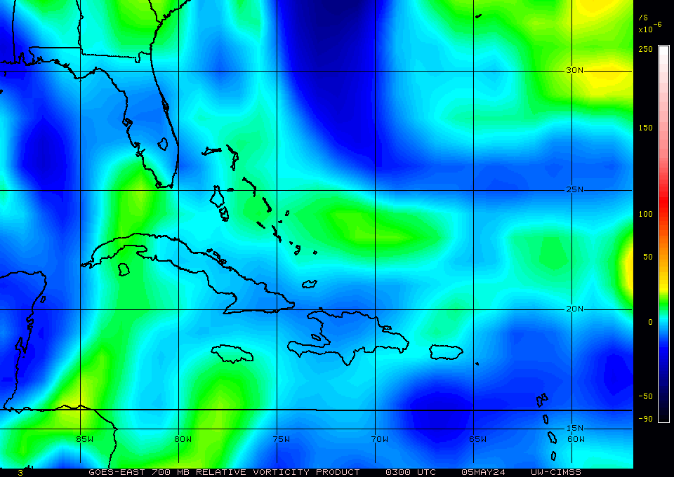
500mb
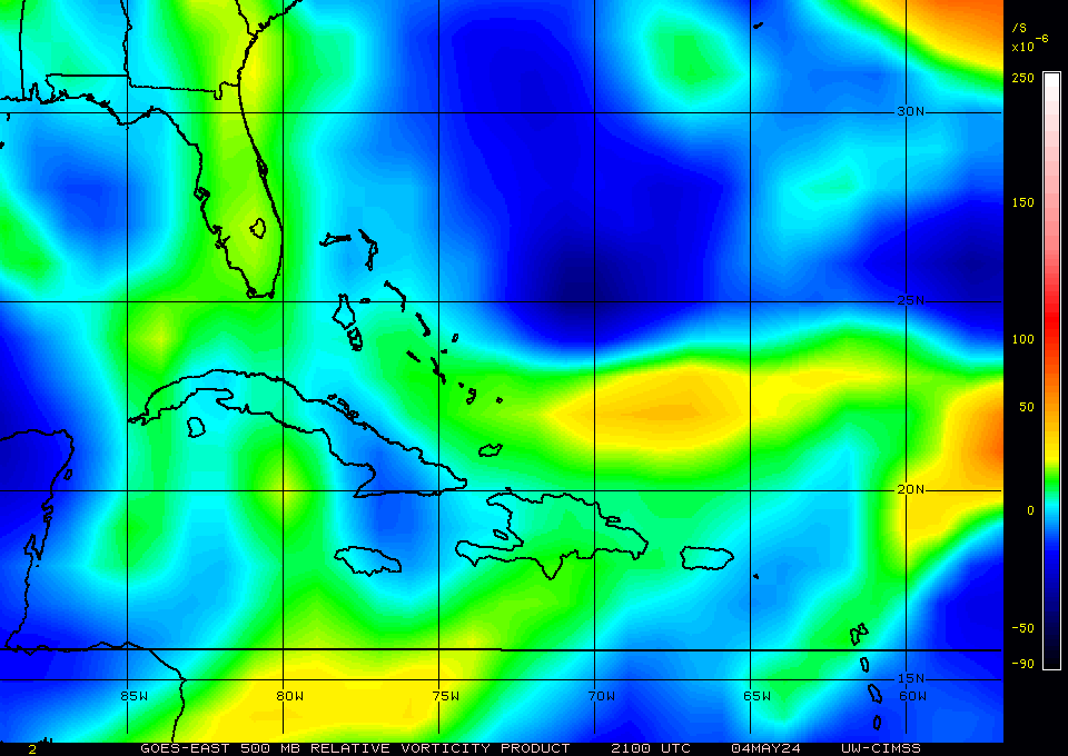
steering

Doesn't want to competely die off does it.
0 likes
The following post is NOT an official forecast and should not be used as such. It is just the opinion of the poster and may or may not be backed by sound meteorological data. It is NOT endorsed by any professional institution including storm2k.org For Official Information please refer to the NHC and NWS products.

The key is whether it makes it into the BoC, probably won't need much room in the BoC to have a shot but not sure it'll get that space.
0 likes
Personal Forecast Disclaimer:
The posts in this forum are NOT official forecast and should not be used as such. They are just the opinion of the poster and may or may not be backed by sound meteorological data. They are NOT endorsed by any professional institution or storm2k.org. For official information, please refer to the NHC and NWS products
The posts in this forum are NOT official forecast and should not be used as such. They are just the opinion of the poster and may or may not be backed by sound meteorological data. They are NOT endorsed by any professional institution or storm2k.org. For official information, please refer to the NHC and NWS products
-
CrazyC83
- Professional-Met
- Posts: 33393
- Joined: Tue Mar 07, 2006 11:57 pm
- Location: Deep South, for the first time!
Re:
HURAKAN wrote:At some point, something gotta give ... excellent upper level conditions, Yucatan may force the low levels to tighten and we could see development in the BOC
Sounds like Bret, José, Lorenzo - type scenario
That is my thinking too. This may end up Earl in the end there (assuming 93L becomes Danielle).
0 likes

-
cycloneye
- Admin
- Posts: 139312
- Age: 67
- Joined: Thu Oct 10, 2002 10:54 am
- Location: San Juan, Puerto Rico
Re: ATL : INVEST 92L - DISCUSSION
Now let's see what it does when it emerges in the BOC. I guess it depends in what latitude the MLC emerges.
0 likes
Visit the Caribbean-Central America Weather Thread where you can find at first post web cams,radars
and observations from Caribbean basin members Click Here
and observations from Caribbean basin members Click Here
Re:
HURAKAN wrote:At some point, something gotta give ... excellent upper level conditions, Yucatan may force the low levels to tighten and we could see development in the BOC
Sounds like Bret, José, Lorenzo - type scenario
I agree but it all depends on whether it makes it to the BoC...if it does make it then the storms you outline certainly could be a decent outline for what may happen, the Yucatan sure does help to tighten everything up at the lower levels usually.
0 likes
Personal Forecast Disclaimer:
The posts in this forum are NOT official forecast and should not be used as such. They are just the opinion of the poster and may or may not be backed by sound meteorological data. They are NOT endorsed by any professional institution or storm2k.org. For official information, please refer to the NHC and NWS products
The posts in this forum are NOT official forecast and should not be used as such. They are just the opinion of the poster and may or may not be backed by sound meteorological data. They are NOT endorsed by any professional institution or storm2k.org. For official information, please refer to the NHC and NWS products

Who is online
Users browsing this forum: No registered users and 24 guests