ATL: Ex Tropical Storm EARL - Discussion

Moderator: S2k Moderators

Message
Author
CrazyC83
Professional-Met
Professional-Met
Posts: 33393
Joined: Tue Mar 07, 2006 11:57 pm
Location: Deep South, for the first time!

Re: ATL: Tropical Storm EARL - Discussion

#4541 Postby CrazyC83 » Sat Sep 04, 2010 7:35 pm

Image

Convection over the center and not frontal - is that really at 50N latitude? I'd keep advisories going at 11 personally...Center looks to be near 50.2N 59.6W. Final landfall looks to be about 30 to 45 minutes away, probably near Tete-a-la-Baleine, Quebec.

It should emerge in the Labrador Sea around 3 am EDT, but the water there is NOT friendly for tropical cyclones at all - SST's there are in the 40s. It would have about 550 miles to reach Greenland.
0 likes   

User avatar
Chacor
Category 5
Category 5
Posts: 10229
Joined: Mon Oct 02, 2006 10:43 pm
Location: Singapore

#4542 Postby Chacor » Sat Sep 04, 2010 9:46 pm

I have an issue with how the NHC has chosen to word its final advisory.

If Earl is a "post-tropical" storm, then they surely cannot say that "tropical storm conditions" are occurring; they should instead use "gale conditions" or "storm conditions" per the Beaufort scale.

Furthermore, this must be the first time I have seen NHC stop advisories when there's still a tropical storm warning in effect!
0 likes   

CrazyC83
Professional-Met
Professional-Met
Posts: 33393
Joined: Tue Mar 07, 2006 11:57 pm
Location: Deep South, for the first time!

#4543 Postby CrazyC83 » Sat Sep 04, 2010 9:46 pm

Indeed last advisory. See you in 2016, Earl!

(I am guessing 0000Z will be a TS and 0600Z will be extratropical in BT, so the official end point will be then).
0 likes   

CrazyC83
Professional-Met
Professional-Met
Posts: 33393
Joined: Tue Mar 07, 2006 11:57 pm
Location: Deep South, for the first time!

Re:

#4544 Postby CrazyC83 » Sat Sep 04, 2010 9:48 pm

Chacor wrote:I have an issue with how the NHC has chosen to word its final advisory.

If Earl is a "post-tropical" storm, then they surely cannot say that "tropical storm conditions" are occurring; they should instead use "gale conditions" or "storm conditions" per the Beaufort scale.

Furthermore, this must be the first time I have seen NHC stop advisories when there's still a tropical storm warning in effect!


I don't agree with the call either, I think they just wanted to give up seeing where it is! Otherwise they would have to issue an intermediate advisory at 2 am and a final advisory at 5 am. Environment Canada will probably drop the warning soon seeing how that is the last advisory though.
0 likes   

User avatar
cycloneye
Admin
Admin
Posts: 139086
Age: 67
Joined: Thu Oct 10, 2002 10:54 am
Location: San Juan, Puerto Rico

Re: ATL: Ex Tropical Storm EARL - Discussion

#4545 Postby cycloneye » Sat Sep 04, 2010 9:50 pm

Here is the very long Best Track file from start to finish.

ftp://ftp.tpc.ncep.noaa.gov/atcf/tcweb/ ... 010.invest
0 likes   
Visit the Caribbean-Central America Weather Thread where you can find at first post web cams,radars
and observations from Caribbean basin members Click Here

CrazyC83
Professional-Met
Professional-Met
Posts: 33393
Joined: Tue Mar 07, 2006 11:57 pm
Location: Deep South, for the first time!

#4546 Postby CrazyC83 » Sat Sep 04, 2010 9:51 pm

Looking at that satellite, what is that blob at 36N 61W? Remnants of Fiona?
0 likes   

User avatar
Chacor
Category 5
Category 5
Posts: 10229
Joined: Mon Oct 02, 2006 10:43 pm
Location: Singapore

#4547 Postby Chacor » Sat Sep 04, 2010 9:54 pm

That 0215 UTC IR clearly shows, as you said earlier, convection still near the centre of Earl, and to be honest it isn't really that frontal yet. If this was in the WPAC I have no doubt the JMA would still be warning on this... and they'd be right.

This is, in my non-professional opinion not affiliated with s2k/NHC/NWS/Environment Canada, not yet a post-tropical storm and still most definitely a TC.
0 likes   

CrazyC83
Professional-Met
Professional-Met
Posts: 33393
Joined: Tue Mar 07, 2006 11:57 pm
Location: Deep South, for the first time!

Re:

#4548 Postby CrazyC83 » Sat Sep 04, 2010 9:57 pm

Chacor wrote:That 0215 UTC IR clearly shows, as you said earlier, convection still near the centre of Earl, and to be honest it isn't really that frontal yet. If this was in the WPAC I have no doubt the JMA would still be warning on this... and they'd be right.

This is, in my non-professional opinion not affiliated with s2k/NHC/NWS/Environment Canada, not yet a post-tropical storm and still most definitely a TC.


Personal Forecast Disclaimer:
The posts in this forum are NOT official forecast and should not be used as such. They are just the opinion of the poster and may or may not be backed by sound meteorological data. They are NOT endorsed by any professional institution or storm2k.org. For official information, please refer to the NHC and NWS products.


I am in agreement. I would have kept it going. It doesn't look frontal to me either. Maybe the BT will show such.

NHC might have also thought that EC would be good enough handling it, since there is nowhere else left - unless it revived itself over 45-50 degree water.

The center looks to be around 50.9N 58.4W at 0215Z, and it was clearly a tropical storm then with likely an intensity of around 50 kt.
0 likes   

User avatar
Category 5
Category 5
Category 5
Posts: 10074
Age: 34
Joined: Sun Feb 11, 2007 10:00 pm
Location: New Brunswick, NJ
Contact:

Re: ATL: Ex Tropical Storm EARL - Discussion

#4549 Postby Category 5 » Sat Sep 04, 2010 10:01 pm

The posts in this forum are NOT official forecast and should not be used as such. They are just the opinion of the poster and may or may not be backed by sound meteorological data. They are NOT endorsed by any professional institution or storm2k.org. For official information, please refer to the NHC and NWS products.

Based on satellite, I do not believe this is post or extratropical I still see convection around the center, I completely agree with Chacor and Crazy on this one. Strongly disagree with the NHC on this one.
0 likes   
Image
"GAME SET MATCH GIANTS WILL WIN THE NFC EAST and have a FIRST ROUND BYE with a win next week!!!" - StormingB81, the Giants lost, and did not win the NFC east.

User avatar
vbhoutex
Storm2k Executive
Storm2k Executive
Posts: 28974
Age: 72
Joined: Wed Oct 09, 2002 11:31 pm
Location: Spring Branch area, Houston, TX
Contact:

Re: ATL: Ex Tropical Storm EARL - Discussion

#4550 Postby vbhoutex » Sat Sep 04, 2010 10:02 pm

I'd like to make a suggestion about this. I think that you guys have some legitimate questions concerning Earl. Email the NHC and tell them what you think and why and ask them why they ended the advisories. I would be interested in their response. They are always open to questions and generally will respond.
0 likes   
Skywarn, C.E.R.T.
Please click below to donate to STORM2K to help with the expenses of keeping the site going:
Image

User avatar
Chacor
Category 5
Category 5
Posts: 10229
Joined: Mon Oct 02, 2006 10:43 pm
Location: Singapore

#4551 Postby Chacor » Sat Sep 04, 2010 10:05 pm

I have my own theory about it, not too dissimilar from what Crazy said earlier. Perhaps it's an issue of resources and Earl no longer being of interest to them.

Take for example the WPac. JTWC stops warning on TCs, even when still at TS strength, as soon as they make landfall and are no longer expected to threaten DOD interests or make it back over water.

I suspect it might not be too different here. The NHC probably wants to refocus its resources now after spending so much of it on Earl. Just my thoughts, might not be accurate of course but hey, we'll not know unless, as you say, someone emails the NHC.
0 likes   

supercane
S2K Supporter
S2K Supporter
Posts: 2856
Joined: Wed Sep 16, 2009 8:27 pm

#4552 Postby supercane » Sat Sep 04, 2010 10:13 pm

Well, I'll start by looking at the NHC's reasoning from the 11PM discussion:
OVER THE PAST FEW HOURS THE WIND FIELD OF EARL HAS BECOME
INCREASINGLY ELONGATED AND THE STRONGEST WINDS ARE NOW WELL REMOVED
FROM THE CENTER. DRY AIR ASSOCIATED WITH THE LARGE UPPER TROUGH
INTERACTING WITH EARL HAS BEEN ENTRAINED THROUGH THE SOUTHERN
SEMICIRCLE OF THE CYCLONE. ALSO...THE EASTERN PORTION OF EARL/S
CIRCULATION IS NOW INVOLVED WITH A FRONTAL ZONE. BASED ON ALL
OF THIS...EARL IS NOW DECLARED POST-TROPICAL

The asymmetric wind field is easy enough verified.
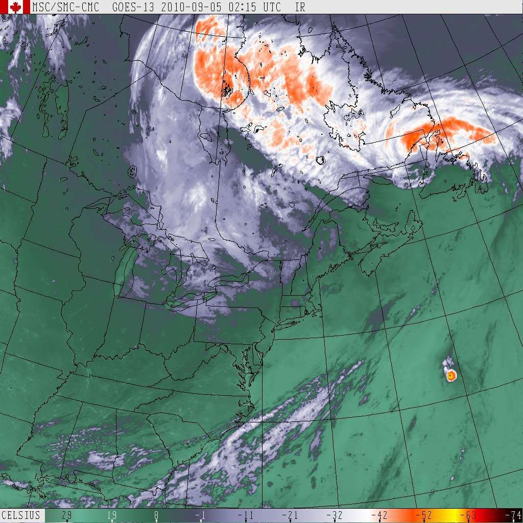
 Analysis from CIRA:
Image
The new 00Z surface analysis is not yet available, but the [url=http://www.opc.ncep.noaa.gov/UA/USA_East.gif]18Z analysis[/quote] would be consistent with NHC's assertion that there is association with the warm front:
Image
Then at the definition of post-tropical:
POST-TROPICAL CYCLONE...A FORMER TROPICAL CYCLONE. THIS GENERIC
TERM DESCRIBES A CYCLONE THAT NO LONGER POSSESSES SUFFICIENT
TROPICAL CHARACTERISTICS TO BE CONSIDERED A TROPICAL CYCLONE.
POST-TROPICAL CYCLONES CAN CONTINUE CARRYING HEAVY RAINS AND
HIGH WINDS. FORMER TROPICAL CYCLONES THAT HAVE BECOME FULLY
EXTRATROPICAL...AS WELL AS REMNANT LOWS...ARE TWO SPECIFIC
CLASSES OF POST-TROPICAL CYCLONES.

AS SUGGESTED BY THE ABOVE DEFINITION...THE NWS WILL CONTINUE TO
USE THE MORE SPECIFIC TERMS OF /REMNANT LOW/ AND /EXTRATROPICAL/
... WHEN APPLICABLE... TO PROVIDE ADDITIONAL INFORMATION ON THE
TYPE OF SYSTEM THE TROPICAL CYCLONE HAS OR IS EXPECTED TO
BECOME. UPDATED DEFINITIONS OF REMNANT LOW AND EXTRATROPICAL
CYCLONE FOLLOW.

REMNANT LOW...A POST-TROPICAL CYCLONE THAT NO LONGER POSSESSES
THE CONVECTIVE ORGANIZATION REQUIRED OF A TROPICAL CYCLONE...AND
HAS MAXIMUM SUSTAINED WINDS OF LESS THAN 34 KNOTS. THE TERM IS
MOST COMMONLY APPLIED TO THE NEARLY DEEP-CONVECTION-FREE SWIRLS
OF STRATOCUMULUS IN THE EASTERN NORTH PACIFIC.

EXTRATROPICAL CYCLONE...A CYCLONE OF ANY INTENSITY FOR WHICH THE
PRIMARY ENERGY SOURCE IS BAROCLINIC /THAT IS...RESULTS FROM THE
TEMPERATURE CONTRAST BETWEEN WARM AND COLD AIR MASSES/.

THE FOLLOWING EXAMPLE SHOWS HOW THE NEW TERMINOLOGY WOULD BE
USED IN THE TABLE SECTION OF A TROPICAL CYCLONE DISCUSSION
PRODUCT FOR THE LAST ADVISORY ON A DECAYING TROPICAL STORM.

IN THIS EXAMPLE...THE SYSTEM HAS LOST THE DEEP CONVECTION
REQUIRED OF A TROPICAL CYCLONE BUT IT DOES NOT YET HAVE ANY
FRONTAL CHARACTERISTICS. IN ADDITION THE SYSTEM CANNOT BE
DESIGNATED A REMNANT LOW BECAUSE ITS MAXIMUM WINDS EXCEED
34 KNOTS. THEREFORE THE SYSTEM IS MERELY DESCRIBED AS
POST-TROPICAL AT THE INITIAL TIME. IN 24 HOURS...HOWEVER...THE
SYSTEM IS FORECAST TO CHANGE STRUCTURE AND BECOME A FRONTAL LOW.
THE /EXTRATROPICAL/ DESIGNATION IS THEREFORE APPENDED IN THE
TABLE TO INDICATE THIS FORECAST CHANGE IN STRUCTURE.

FORECAST POSITIONS AND MAX WINDS

INITIAL 01/1500Z 46.5N 46.5W 40 KT...POST-TROPICAL
12HR VT 02/0000Z 48.9N 45.6W 40 KT...POST-TROPICAL
24HR VT 02/1200Z 52.2N 43.5W 40 KT...POST-TROP/EXTRATROP
36HR VT 03/0000Z 55.0N 39.8W 40 KT...POST-TROP/EXTRATROP
48HR VT 03/1200Z 56.0N 33.0W 40 KT...POST-TROP/EXTRATROP
72HR VT 04/1200Z 56.5N 20.0W 40 KT...POST-TROP/EXTRATROP
96HR VT 05/1200Z...ABSORBED

To me, given the above definition combined with the characteristics noted by the NHC above, Earl would qualify as "post-tropical" but not yet "extratropical." I agree with the incongruity of continued warnings in effect with NHC's last advisory, but it is always the national meteorological center and not NHC who is responsible for warnings. NHC may continue advisories after speaking to Environment Canada as a courtesy, but as the regional RMSC if the system does not meet criteria for advisories it cannot be compelled to do so just because there is a difference of opinions. Perhaps as a nod to Canada NHC is stating tropical storm conditions although as mentioned above gale conditions is more appropriate given NHC's designation.
0 likes   

supercane
S2K Supporter
S2K Supporter
Posts: 2856
Joined: Wed Sep 16, 2009 8:27 pm

#4553 Postby supercane » Sat Sep 04, 2010 10:22 pm

BTW, Environment Canada is also calling Earl post-tropical. Their latest advisory:
WOCN31 CWHX 050300
Post-tropical storm Earl intermediate information statement
Issued by the Canadian Hurricane Centre of Environment Canada
At 12.30 AM NDT Saturday 05 September 2010.

The next statement will be issued by 3.30 AM NDT

At midnight ADT... Post-tropical storm Earl was located near
Latitude 51.4 N and longitude 57.6 W... About 55 nautical miles
Or 100 km west of st anthony.

Earl is moving towards the north northeast at 24 knots... 45
Km/h. Maximum sustained winds are estimated at 55 knots... 102
Km/h and central pressure at 974 MB.

In addition to the strong winds which were observed in Nova Scotia,
here were the recorded peak wave heights from a few of our reporting
bouys:

East Scotian Slope 18.3 m
Halifax harbour 23.3 m
Lahave Bank 25.1 m

Public and marine interests are advised to monitor forecasts
And warnings issued for their region by Environment Canada.

End March/borgel
0 likes   

User avatar
Chacor
Category 5
Category 5
Posts: 10229
Joined: Mon Oct 02, 2006 10:43 pm
Location: Singapore

#4554 Postby Chacor » Sat Sep 04, 2010 10:23 pm

I wouldn't be surprised if that was to be consistent with NHC.
0 likes   

CrazyC83
Professional-Met
Professional-Met
Posts: 33393
Joined: Tue Mar 07, 2006 11:57 pm
Location: Deep South, for the first time!

#4555 Postby CrazyC83 » Sat Sep 04, 2010 10:25 pm

A good indication would be to wait until 06Z and see what it looks like then, as that is the next point on the Best Track and what would have been the intermediate advisory.
0 likes   

supercane
S2K Supporter
S2K Supporter
Posts: 2856
Joined: Wed Sep 16, 2009 8:27 pm

#4556 Postby supercane » Sat Sep 04, 2010 10:27 pm

Chacor wrote:I wouldn't be surprised if that was to be consistent with NHC.

Nor would I, but if Environment Canada had no qualms about calling Earl a hurricane earlier today even though it had been designated a tropical storm by NHC for 12 hrs, surely they wouldn't hesitate to call Earl tropical if they truly believed it. As outlined above, I cannot disagree with NHC's given reasons for declaring Earl post-tropical, as that does not require the system to be extratropical, and as far as one can tell, apparently neither can Environment Canada.
0 likes   

User avatar
Hybridstorm_November2001
S2K Supporter
S2K Supporter
Posts: 2802
Joined: Sat Aug 21, 2004 2:50 pm
Location: SW New Brunswick, Canada
Contact:

Re: ATL: Ex Tropical Storm EARL - Discussion

#4557 Postby Hybridstorm_November2001 » Sat Sep 04, 2010 11:03 pm

0 likes   

WeatherGuesser
Category 5
Category 5
Posts: 2672
Joined: Tue Jun 29, 2010 6:46 am

#4558 Postby WeatherGuesser » Sat Sep 04, 2010 11:26 pm

CBC story says they clocked winds at 135Km/H

http://www.cbc.ca/canada/nova-scotia/st ... -hits.html
0 likes   

User avatar
Chacor
Category 5
Category 5
Posts: 10229
Joined: Mon Oct 02, 2006 10:43 pm
Location: Singapore

#4559 Postby Chacor » Sat Sep 04, 2010 11:55 pm

I'd guess that would be gusts, not sustained. That's in hurricane strength territory.
0 likes   

User avatar
Category 5
Category 5
Category 5
Posts: 10074
Age: 34
Joined: Sun Feb 11, 2007 10:00 pm
Location: New Brunswick, NJ
Contact:

Re: ATL: Ex Tropical Storm EARL - Discussion

#4560 Postby Category 5 » Sun Sep 05, 2010 12:35 pm

vbhoutex wrote:I'd like to make a suggestion about this. I think that you guys have some legitimate questions concerning Earl. Email the NHC and tell them what you think and why and ask them why they ended the advisories. I would be interested in their response. They are always open to questions and generally will respond.


Done
0 likes   
Image
"GAME SET MATCH GIANTS WILL WIN THE NFC EAST and have a FIRST ROUND BYE with a win next week!!!" - StormingB81, the Giants lost, and did not win the NFC east.


Return to “2010”

Who is online

Users browsing this forum: No registered users and 121 guests